ATL: ZETA - Post-Tropical - Discussion

Moderator: S2k Moderators

Message
Author
User avatar
SFLcane
S2K Supporter
S2K Supporter
Posts: 10163
Age: 47
Joined: Sat Jun 05, 2010 1:44 pm
Location: Lake Worth Florida

Re: ATL: INVEST 95L - Discussion

#201 Postby SFLcane » Fri Oct 23, 2020 6:35 pm

underthwx wrote:From NWS Miami Forecast Discussion..."The long term period will start off very active as we watch to see
what Invest 95L does in the western Caribbean this weekend and
into early next week. Globals are all over the map with the
evolution, however, confidence is high for additional heavy
rain/hydro concerns (see hydro section below). Globals want to
pull the system northward and eventually west across the Gulf of
Mexico through the middle part of the week. At this juncture,
regardless of development into a weak system, the message is
clear...heavy rain through the start of the next workweek. Some
improvement is then expected on the back half of the long term
period as a Bermuda high noses into the region. That will not
completely erase POPs for the second half of the week, but may
help suppress the chances just a bit"....This is a part of NWS Miami Forecast Discussion. Sounds like alot of uncertainty at work here regarding 95L...I am inclined to believe it won't travel westward across the GOM, not with a front due next week...


This!
0 likes   

TheStormExpert

Re: ATL: INVEST 95L - Discussion

#202 Postby TheStormExpert » Fri Oct 23, 2020 6:38 pm

I’m surprised they didn’t up development chances with the way it’s looking now. :eek:

Image
2 likes   

User avatar
wxman57
Moderator-Pro Met
Moderator-Pro Met
Posts: 22978
Age: 67
Joined: Sat Jun 21, 2003 8:06 pm
Location: Houston, TX (southwest)

Re: ATL: INVEST 95L - Discussion

#203 Postby wxman57 » Fri Oct 23, 2020 6:40 pm

Very good video by Levi (Tropical Tidbits) explaining the situation. The quicker it develops, the farther east, maybe east of Florida then back west to the FL Peninsula. If it heads for the central Gulf then it's toast - too much dry air and shear. Could make it to the FL Panhandle as a TS, perhaps. Not a strong one, though. Best environment may well be south of Cuba this weekend.
3 likes   

Sanibel
Category 5
Category 5
Posts: 10375
Joined: Mon Aug 30, 2004 11:06 pm
Location: Offshore SW Florida

ATL: INVEST 95L - Discussion

#204 Postby Sanibel » Fri Oct 23, 2020 7:04 pm

Has curvature signs of snapping together...IMO...

Sooner rather than later I would say...
2 likes   

User avatar
SFLcane
S2K Supporter
S2K Supporter
Posts: 10163
Age: 47
Joined: Sat Jun 05, 2010 1:44 pm
Location: Lake Worth Florida

Re: ATL: INVEST 95L - Discussion

#205 Postby SFLcane » Fri Oct 23, 2020 7:10 pm

Sanibel wrote:Has curvature signs of snapping together...IMO...

Sooner rather than later I would say...


Actually I was about to say it seems organization seems to have leveled atleast based along on satellite appearance. 18z guidance trended weaker with the Hwrf into the gulf were it will get it’s head chopped off. We will see what tomorrow brings
3 likes   

Frank2
Category 5
Category 5
Posts: 4061
Joined: Mon Jul 25, 2005 12:47 pm

Re: ATL: INVEST 95L - Discussion

#206 Postby Frank2 » Fri Oct 23, 2020 7:12 pm

The models are not bullish on intensity... but we at S2K know better. This thing is literally sitting on top of the highest ocean heat content in the basin (perhaps the highest on the planet). A decade of almost undisturbed ocean water that is heated to great depths. It feels like we're watching a lit fuse burn its way toward a pile of explosives.


That's pretty good fiction writing - the SST down there is about average for October...

https://www.ospo.noaa.gov/Products/ocea ... index.html
Last edited by Frank2 on Fri Oct 23, 2020 7:15 pm, edited 1 time in total.
0 likes   

User avatar
ElectricStorm
Category 5
Category 5
Posts: 5044
Age: 24
Joined: Tue Aug 13, 2019 11:23 pm
Location: Skiatook, OK / Norman, OK

Re: ATL: INVEST 95L - Discussion

#207 Postby ElectricStorm » Fri Oct 23, 2020 7:15 pm

Frank2 wrote:
The models are not bullish on intensity... but we at S2K know better. This thing is literally sitting on top of the highest ocean heat content in the basin (perhaps the highest on the planet). A decade of almost undisturbed ocean water that is heated to great depths. It feels like we're watching a lit fuse burn its way toward a pile of explosives.


That's pretty good fiction writing even for this site - the SST down there is about average for October...

https://www.ospo.noaa.gov/Products/ocea ... index.html

That's why he said OHC and not SSTs. The OHC down there is pretty extreme. The 2 storms this month that formed in the Caribbean RI'd because of that. Depending on how much time this one has, it could make a run for hurricane status. And storms don't need record SST's to blow up *looks at Epsilon*
2 likes   
B.S Meteorology, University of Oklahoma '25

Please refer to the NHC, NWS, or SPC for official information.

User avatar
aspen
Category 5
Category 5
Posts: 8818
Joined: Sat Oct 12, 2019 7:10 pm
Location: Connecticut, USA

Re: ATL: INVEST 95L - Discussion

#208 Postby aspen » Fri Oct 23, 2020 7:16 pm

In my unprofessional opinion, it seems like 95L might try to concentrate S or SE of the Cayman Islands, not right on top or N of them.
3 likes   
Irene '11 Sandy '12 Hermine '16 5/15/2018 Derecho Fay '20 Isaias '20 Elsa '21 Henri '21 Ida '21

I am only a meteorology enthusiast who knows a decent amount about tropical cyclones. Look to the professional mets, the NHC, or your local weather office for the best information.

ClarCari
Category 2
Category 2
Posts: 579
Joined: Thu Aug 13, 2020 11:02 am

Re: ATL: INVEST 95L - Discussion

#209 Postby ClarCari » Fri Oct 23, 2020 7:19 pm

aspen wrote:In my unprofessional opinion, it seems like 95L might try to concentrate S or SE of the Cayman Islands, not right on top or N of them.

I was also thinking something like that as some of the ascats from a couple hours ago showed that original center becoming weaker, which lead me to think a relocation might be happening.
Essentially this would put it even further under that anticyclone and give it more time over water before hitting Cuba. If it become a TS by anytime tomorrow I would be shocked if it didn’t become a hurricane.
1 likes   

User avatar
gatorcane
S2K Supporter
S2K Supporter
Posts: 23691
Age: 47
Joined: Sun Mar 13, 2005 3:54 pm
Location: Boca Raton, FL

Re: ATL: INVEST 95L - Discussion

#210 Postby gatorcane » Fri Oct 23, 2020 7:39 pm

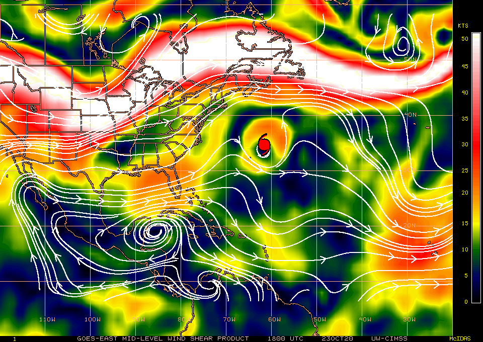
The upper anticyclone is over top (not shown below) but the mid-level shear from the north looks to be an issue, perhaps why some convection is waning:

Image
0 likes   

jhpigott
Category 2
Category 2
Posts: 570
Joined: Wed Jan 02, 2008 8:09 pm
Location: North Palm Beach, Florida

Re: ATL: INVEST 95L - Discussion

#211 Postby jhpigott » Fri Oct 23, 2020 7:40 pm

wxman57 wrote:Very good video by Levi (Tropical Tidbits) explaining the situation. The quicker it develops, the farther east, maybe east of Florida then back west to the FL Peninsula. If it heads for the central Gulf then it's toast - too much dry air and shear. Could make it to the FL Panhandle as a TS, perhaps. Not a strong one, though. Best environment may well be south of Cuba this weekend.


Do you think Irene 99' redux is on the table here?
1 likes   

Sanibel
Category 5
Category 5
Posts: 10375
Joined: Mon Aug 30, 2004 11:06 pm
Location: Offshore SW Florida

ATL: INVEST 95L - Discussion

#212 Postby Sanibel » Fri Oct 23, 2020 7:45 pm

SFLcane wrote:
Sanibel wrote:Has curvature signs of snapping together...IMO...

Sooner rather than later I would say...


Actually I was about to say it seems organization seems to have leveled atleast based along on satellite appearance. 18z guidance trended weaker with the Hwrf into the gulf were it will get it’s head chopped off. We will see what tomorrow brings


Grasshopper: Watch for the right blob by Jamaica to diminish and the center to burst...
0 likes   

User avatar
Blown Away
S2K Supporter
S2K Supporter
Posts: 10145
Joined: Wed May 26, 2004 6:17 am

Re: ATL: INVEST 95L - Discussion

#213 Postby Blown Away » Fri Oct 23, 2020 7:49 pm

Based on current modeling and climatology, IF 95L becomes a strong TS or Hurricane it will likely move NE over Cuba, near/over SFL, then through Bahamas... If 95L stays weak it will go NW and get absorbed as the cold front sweeps down...
0 likes   
Hurricane Eye Experience: David 79, Irene 99, Frances 04, Jeanne 04, Wilma 05... EYE COMING MY WAY IN 2024…
Hurricane Brush Experience: Andrew 92, Erin 95, Floyd 99, Matthew 16, Irma 17, Ian 22, Nicole 22…

User avatar
northjaxpro
S2K Supporter
S2K Supporter
Posts: 8900
Joined: Mon Sep 27, 2010 11:21 am
Location: Jacksonville, FL

..

#214 Postby northjaxpro » Fri Oct 23, 2020 7:55 pm

...Great discussion and presentation by Levi on TT on 95L!!
2 likes   
NEVER, EVER SAY NEVER in the tropics and weather in general, and most importantly, with life itself!!

________________________________________________________________________________________

Fay 2008 Beryl 2012 Debby 2012 Colin 2016 Hermine 2016 Julia 2016 Matthew 2016 Irma 2017 Dorian 2019

cp79

Re: ATL: INVEST 95L - Discussion

#215 Postby cp79 » Fri Oct 23, 2020 9:13 pm

Wherever this goes, the right side of this system is nasty. So a ride up the Eastern GOM would prolly be worst case scenario for most of Fla in that it would deliver heavy rainfall for most of the peninsula and hit the panhandle area. A center that skirts SE Fla isn’t the worst thing as most of the bad weather would miss the US.
1 likes   

User avatar
SFLcane
S2K Supporter
S2K Supporter
Posts: 10163
Age: 47
Joined: Sat Jun 05, 2010 1:44 pm
Location: Lake Worth Florida

Re: ATL: INVEST 95L - Discussion

#216 Postby SFLcane » Fri Oct 23, 2020 9:17 pm

00z guidance much weaker perhaps a flash in the pan with this one? If it goes west into the GOM its toast. Not overly concerned based on what I am seeing tonight other then more rainy weather for the Florida peninsula. :sleeping:
1 likes   

underthwx
Category 5
Category 5
Posts: 2360
Joined: Sat Jul 30, 2011 2:14 pm
Location: Brazoria County Texas

Re: ATL: INVEST 95L - Discussion

#217 Postby underthwx » Fri Oct 23, 2020 10:16 pm

95L not looking as impressive as earlier, maybe loss of daytime heating?....I anticipate it will again be looking much healthier tomorrow?...95L is proving itself to be a slow starter from the git-go...
0 likes   

ClarCari
Category 2
Category 2
Posts: 579
Joined: Thu Aug 13, 2020 11:02 am

Re: ATL: INVEST 95L - Discussion

#218 Postby ClarCari » Fri Oct 23, 2020 10:21 pm

underthwx wrote:95L not looking as impressive as earlier, maybe loss of daytime heating?....I anticipate it will again be looking much healthier tomorrow?...95L is proving itself to be a slow starter from the git-go...

Just typical DMIN waning, nothing really unusual and not a sign of it losing steam, if anything it’s popcorning cold clouds again and it’s right now doing it around almost in a “circle” hmmmm...so i’d say it’s still well on it’s way and DMAX could give it a big push.
4 likes   

underthwx
Category 5
Category 5
Posts: 2360
Joined: Sat Jul 30, 2011 2:14 pm
Location: Brazoria County Texas

Re: ATL: INVEST 95L - Discussion

#219 Postby underthwx » Fri Oct 23, 2020 10:31 pm

ClarCari wrote:
underthwx wrote:95L not looking as impressive as earlier, maybe loss of daytime heating?....I anticipate it will again be looking much healthier tomorrow?...95L is proving itself to be a slow starter from the git-go...

Just typical DMIN waning, nothing really unusual and not a sign of it losing steam, if anything it’s popcorning cold clouds again and it’s right now doing it around almost in a “circle” hmmmm...so i’d say it’s still well on it’s way and DMAX could give it a big push.


Well said...agreed
0 likes   

cp79

Re: ATL: INVEST 95L - Discussion

#220 Postby cp79 » Fri Oct 23, 2020 10:35 pm

Yeah not looking good for 95L. Could be heading for a slow death here soon.
0 likes   


Return to “2020”

Who is online

Users browsing this forum: No registered users and 9 guests