Trough of low pressure in Western Caribbean (Is Invest 95L)
Moderator: S2k Moderators
Forum rules

The posts in this forum are NOT official forecasts and should not be used as such. They are just the opinion of the poster and may or may not be backed by sound meteorological data. They are NOT endorsed by any professional institution or STORM2K. For official information, please refer to products from the National Hurricane Center and National Weather Service.
-
StPeteMike

- Category 2

- Posts: 657
- Joined: Thu Jun 07, 2018 11:26 pm
Re: Possible SW Caribbean Development
I doubt it will get dropped.
0 likes
The above post is not official and should not be used as such. It is the opinion of the poster and may or may not be backed by sound meteorological data. It is not endorsed by any professional institution or storm2k.org. For official information, please refer to the NHC and NWS products.
-
ElectricStorm

- Category 5

- Posts: 5157
- Age: 25
- Joined: Tue Aug 13, 2019 11:23 pm
- Location: Norman, OK
Re: Possible SW Caribbean Development
As Hurricaneman pointed out earlier, the GFS keeps trying to spin it up on the far NE of the gyre. I really don't see that happening, and I think we will get something going down there before it reaches Cuba.
0 likes
B.S Meteorology, University of Oklahoma '25
Please refer to the NHC, NWS, or SPC for official information.
Please refer to the NHC, NWS, or SPC for official information.

Re: Possible SW Caribbean Development
Meanwhile CMC no longer kicks out and gets left behind in the Bahamas. The NE movement on the models is out. Anything that develops will get trapped waiting for next front to pick it out. More typical evolution. I expect the Euro to give a little and show a little more development on this next run.
0 likes
The following post is NOT an official forecast and should not be used as such. It is just the opinion of the poster and may or may not be backed by sound meteorological data. It is NOT endorsed by any professional institution including storm2k.org For Official Information please refer to the NHC and NWS products.
-
TheStormExpert
Re: Possible SW Caribbean Development
blp wrote:No development. Absorbed by the front. I think it has the right idea intially through 180hrs starting slow but I think it will develop once in the NW Carribean just south of Cuba.
So basically we went initially from development beginning tomorrow the 19th to development not happening until next Sunday the 25th?
Smells like a ghost storm to me! Might as well be as it’s Halloween.
1 likes
-
ElectricStorm
- Category 5
- Posts: 5157
- Age: 25
- Joined: Tue Aug 13, 2019 11:23 pm
- Location: Norman, OK
Re: Possible SW Caribbean Development
TheStormExpert wrote:blp wrote:No development. Absorbed by the front. I think it has the right idea intially through 180hrs starting slow but I think it will develop once in the NW Carribean just south of Cuba.
So basically we went initially from development beginning tomorrow the 19th to development not happening until next Sunday the 25th?
Smells like a ghost storm to me! Might as well be as it’s Halloween.
No. The initial gyre is supposed to form in the next few days with actual development shortly after that I believe. Again, it's just one run so we will have to see what future runs have in store.
0 likes
B.S Meteorology, University of Oklahoma '25
Please refer to the NHC, NWS, or SPC for official information.
Please refer to the NHC, NWS, or SPC for official information.
-
ElectricStorm
- Category 5
- Posts: 5157
- Age: 25
- Joined: Tue Aug 13, 2019 11:23 pm
- Location: Norman, OK
Re: Possible SW Caribbean Development
I know the ICON isn't one of the more reliable models, but I think it's run is more likely than this GFS run.
0 likes
B.S Meteorology, University of Oklahoma '25
Please refer to the NHC, NWS, or SPC for official information.
Please refer to the NHC, NWS, or SPC for official information.
-
TheStormExpert
Re: Possible SW Caribbean Development
Weather Dude wrote:TheStormExpert wrote:blp wrote:No development. Absorbed by the front. I think it has the right idea intially through 180hrs starting slow but I think it will develop once in the NW Carribean just south of Cuba.
So basically we went initially from development beginning tomorrow the 19th to development not happening until next Sunday the 25th?
Smells like a ghost storm to me! Might as well be as it’s Halloween.
No. The initial gyre is supposed to form in the next few days with actual development shortly after that I believe. Again, it's just one run so we will have to see what future runs have in store.
Looking back at last Sunday’s 00z run on Tropical Tidbits development was supposed to start tomorrow.
Valid for 06z Monday October 19th.

0 likes
-
ElectricStorm
- Category 5
- Posts: 5157
- Age: 25
- Joined: Tue Aug 13, 2019 11:23 pm
- Location: Norman, OK
Re: Possible SW Caribbean Development
Unchanged on TWO
2. A broad area of low pressure is expected to form in a few days
over the southwestern Caribbean Sea. Some gradual development of
this system will be possible through the middle of next week while
it moves slowly northward or north-northwestward over the western
Caribbean Sea.
* Formation chance through 48 hours...low...near 0 percent.
* Formation chance through 5 days...low...30 percent.
0 likes
B.S Meteorology, University of Oklahoma '25
Please refer to the NHC, NWS, or SPC for official information.
Please refer to the NHC, NWS, or SPC for official information.
-
TheStormExpert
Re: Possible SW Caribbean Development
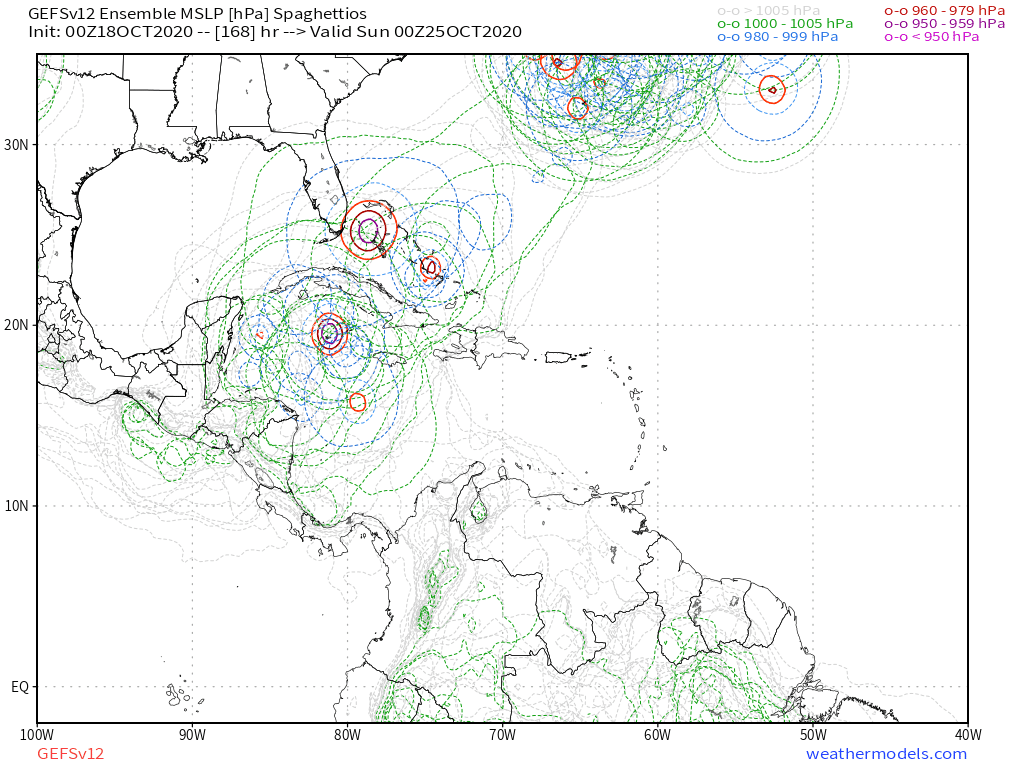
Most 00z GEFS Ensembles kill it over Cuba in just over a week.

0 likes
-
AutoPenalti
- Category 5
- Posts: 4091
- Age: 29
- Joined: Mon Aug 17, 2015 4:16 pm
- Location: Ft. Lauderdale, Florida
Re: Possible SW Caribbean Development
Sounds like NHC will keep those numbers at 30%, they are probably also considering the alternative and that is that there is a chance that this may not develop at all.
0 likes
The posts in this forum are NOT official forecasts and should not be used as such. They are just the opinion of the poster and may or may not be backed by sound meteorological data. They are NOT endorsed by any professional institution or STORM2K. For official information, please refer to products from the NHC and NWS.
Model Runs Cheat Sheet:
GFS (5:30 AM/PM, 11:30 AM/PM)
HWRF, GFDL, UKMET, NAVGEM (6:30-8:00 AM/PM, 12:30-2:00 AM/PM)
ECMWF (1:45 AM/PM)
TCVN is a weighted averaged
-
SFLcane

- S2K Supporter

- Posts: 10281
- Age: 48
- Joined: Sat Jun 05, 2010 1:44 pm
- Location: Lake Worth Florida
Re: Possible SW Caribbean Development
TheStormExpert wrote:Most 00z GEFS Ensembles kill it over Cuba in just over a week.
Though the gfs operational continues to trend weaker what ensembles are you looking at?
0 likes
-
TheStormExpert
Re: Possible SW Caribbean Development
SFLcane wrote:TheStormExpert wrote:Most 00z GEFS Ensembles kill it over Cuba in just over a week.
Though the gfs operational continues to trend weaker what ensembles are you looking at?
https://i.postimg.cc/FRqZstbd/C272-F20-E-F410-44-FD-9707-8-A553-CB556-C2.png

0 likes
-
cycloneye

- Admin

- Posts: 149762
- Age: 69
- Joined: Thu Oct 10, 2002 10:54 am
- Location: San Juan, Puerto Rico
Re: Possible SW Caribbean Development
06z GFS barely develops and this after all the hype of wiper model solutions from this model in the past 8 days.
0 likes
Visit the Caribbean-Central America Weather Thread where you can find at first post web cams,radars
and observations from Caribbean basin members Click Here
and observations from Caribbean basin members Click Here
-
cycloneye
- Admin
- Posts: 149762
- Age: 69
- Joined: Thu Oct 10, 2002 10:54 am
- Location: San Juan, Puerto Rico
Re: Possible SW Caribbean Development
8 AM with no change in the text but in the graphic,the yellow area extends to the NW.

A broad area of low pressure is expected to form in a couple of
days over the southwestern Caribbean Sea. Some gradual development
of this system will be possible through the middle of the week as
it moves slowly northward or north-northwestward over the western
Caribbean Sea.
* Formation chance through 48 hours...low...near 0 percent.
* Formation chance through 5 days...low...30 percent.
0 likes
Visit the Caribbean-Central America Weather Thread where you can find at first post web cams,radars
and observations from Caribbean basin members Click Here
and observations from Caribbean basin members Click Here

Re: Possible SW Caribbean Development
It looks like we have been chasing a phantom storm for over a week now incredible.
0 likes
-
SFLcane
- S2K Supporter
- Posts: 10281
- Age: 48
- Joined: Sat Jun 05, 2010 1:44 pm
- Location: Lake Worth Florida
Re: Possible SW Caribbean Development
cycloneye wrote:06z GFS barely develops and this after all the hype of wiper model solutions from this model in the past 8 days.
On the contrary the GEFS remains active.
0 likes

Re: Possible SW Caribbean Development
What is keeping this from developing on the models? The disturbance have a trackable vorticity, and it’s over water for anywhere from 4 to 7 days. Odds are that something develops from this.
I checked the GFS’ relatively humidity and 200mb wind graphics, and I don’t see anything problematic. Conditions seem fairly good for development — 29-30C SSTs, high OHC, a nice big moisture field, low shear aloft, and perhaps even an anticyclone over the system.
I checked the GFS’ relatively humidity and 200mb wind graphics, and I don’t see anything problematic. Conditions seem fairly good for development — 29-30C SSTs, high OHC, a nice big moisture field, low shear aloft, and perhaps even an anticyclone over the system.
2 likes
Irene '11 Sandy '12 Hermine '16 5/15/2018 Derecho Fay '20 Isaias '20 Elsa '21 Henri '21 Ida '21
I am only a meteorology enthusiast who knows a decent amount about tropical cyclones. Look to the professional mets, the NHC, or your local weather office for the best information.
I am only a meteorology enthusiast who knows a decent amount about tropical cyclones. Look to the professional mets, the NHC, or your local weather office for the best information.
-
cycloneye
- Admin
- Posts: 149762
- Age: 69
- Joined: Thu Oct 10, 2002 10:54 am
- Location: San Juan, Puerto Rico
Re: Possible SW Caribbean Development
0 likes
Visit the Caribbean-Central America Weather Thread where you can find at first post web cams,radars
and observations from Caribbean basin members Click Here
and observations from Caribbean basin members Click Here
-
toad strangler

- S2K Supporter
- Posts: 4546
- Joined: Sun Jul 28, 2013 3:09 pm
- Location: Earth
- Contact:
Re: Possible SW Caribbean Development
cycloneye wrote:https://twitter.com/AndyHazelton/status/1317804043671113729
The GFS did have a W Caribbean ghost earlier in the season as well.
0 likes
My Weather Station
https://www.wunderground.com/dashboard/pws/KFLPORTS603
https://www.wunderground.com/dashboard/pws/KFLPORTS603
Re: Possible SW Caribbean Development
toad strangler wrote:cycloneye wrote:https://twitter.com/AndyHazelton/status/1317804043671113729
The GFS did have a W Caribbean ghost earlier in the season as well.
If this is a ghost, it’s by far the most consistent and believable ghost ever. There’s still a trackable disturbance to watch for genesis that’ll emerge in the Caribbean at the same time frame the GFS was predicting over a week ago.
If you look at my post above, conditions seem pretty solid for development, so I have no idea what the models are seeing that prohibits genesis.
5 likes
Irene '11 Sandy '12 Hermine '16 5/15/2018 Derecho Fay '20 Isaias '20 Elsa '21 Henri '21 Ida '21
I am only a meteorology enthusiast who knows a decent amount about tropical cyclones. Look to the professional mets, the NHC, or your local weather office for the best information.
I am only a meteorology enthusiast who knows a decent amount about tropical cyclones. Look to the professional mets, the NHC, or your local weather office for the best information.
Who is online
Users browsing this forum: tolakram and 142 guests