https://twitter.com/andyhazelton/status/1317498849057976324
Trough of low pressure in Western Caribbean (Is Invest 95L)
Moderator: S2k Moderators
Forum rules

The posts in this forum are NOT official forecasts and should not be used as such. They are just the opinion of the poster and may or may not be backed by sound meteorological data. They are NOT endorsed by any professional institution or STORM2K. For official information, please refer to products from the National Hurricane Center and National Weather Service.
-
SFLcane

- S2K Supporter

- Posts: 10281
- Age: 48
- Joined: Sat Jun 05, 2010 1:44 pm
- Location: Lake Worth Florida
Re: Possible SW Caribbean Development
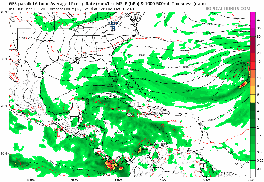
Strong signal coming for the 12z gfs ensembles at 156hrs..
2 likes
-
cycloneye

- Admin

- Posts: 149753
- Age: 69
- Joined: Thu Oct 10, 2002 10:54 am
- Location: San Juan, Puerto Rico
Re: Possible SW Caribbean Development
2 PM:
A broad area of low pressure is expected to form in a few days
over the southwestern Caribbean Sea. Some gradual development of
this system will be possible through the middle of next week while
it moves slowly northward or north-northwestward over the western
Caribbean Sea.
* Formation chance through 48 hours...low...near 0 percent.
* Formation chance through 5 days...low...30 percent.
0 likes
Visit the Caribbean-Central America Weather Thread where you can find at first post web cams,radars
and observations from Caribbean basin members Click Here
and observations from Caribbean basin members Click Here
-
gatorcane

- S2K Supporter
- Posts: 23708
- Age: 48
- Joined: Sun Mar 13, 2005 3:54 pm
- Location: Boca Raton, FL
Re: Possible SW Caribbean Development
SFLcane wrote:Strong signal coming for the 12z gfs ensembles at 156hrs..
Saved loop, they did shift west some and very close to Florida with some landfalls:
2 likes
-
TheStormExpert
Re: Possible SW Caribbean Development
Does the UKMET show anything? I never see anyone talk about it anymore.
0 likes
-
SFLcane
- S2K Supporter
- Posts: 10281
- Age: 48
- Joined: Sat Jun 05, 2010 1:44 pm
- Location: Lake Worth Florida
Re: Possible SW Caribbean Development
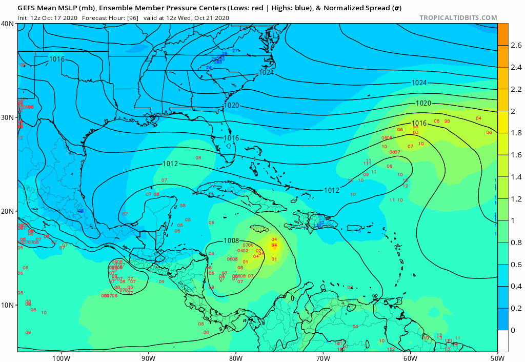
Look at how some ensembles head west in the Bahamas 


Last edited by SFLcane on Sat Oct 17, 2020 12:37 pm, edited 1 time in total.
3 likes
-
gatorcane
- S2K Supporter
- Posts: 23708
- Age: 48
- Joined: Sun Mar 13, 2005 3:54 pm
- Location: Boca Raton, FL
Re: Possible SW Caribbean Development
TheStormExpert wrote:Does the UKMET show anything? I never see anyone talk about it anymore.
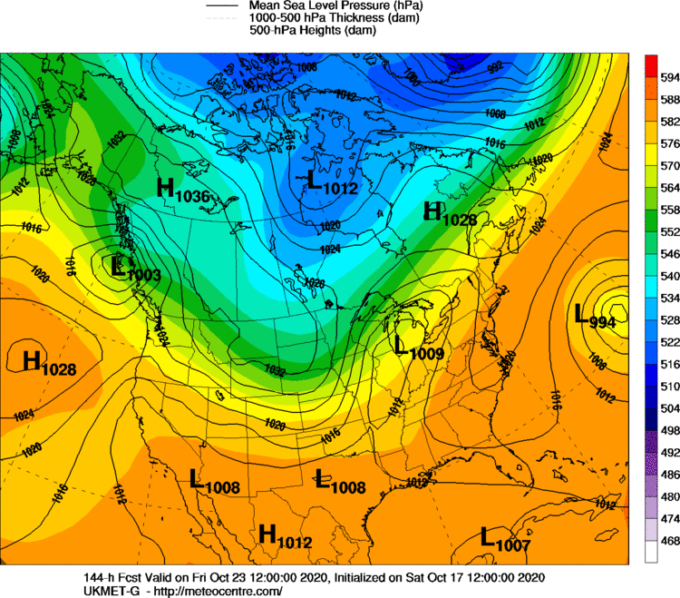
It is showing a weak low actually and further west than the GFS and CMC:
0 likes
-
gatorcane
- S2K Supporter
- Posts: 23708
- Age: 48
- Joined: Sun Mar 13, 2005 3:54 pm
- Location: Boca Raton, FL
Re: Possible SW Caribbean Development
TheStormExpert wrote:https://twitter.com/andyhazelton/status/1317498849057976324
Yes it seems the GFS is pushing back significant development until after crossing Cuba. I notice the CMC and NAVGEM are doing the same. Euro is up now, let’s see if there are any drastic changes. It has yet to show any development of this potential low.
0 likes
-
cp79
Re: Possible SW Caribbean Development
So I see the GFs is celebrating Happy Hour a little early today. That’s some insane run. As someone who lives in Tampa, all I have to say is thank god it’s a drunk run. No way that happens to us.
0 likes
-
TheStormExpert
Re: Possible SW Caribbean Development
After a week is when most GEFS ensembles diverge. But for now this potential system is expected to cross Central Cuba next weekend.
0 likes

Re: Possible SW Caribbean Development
Here's the key folks. Anyone notice what date that the GFS and GFS-Para were forecasting a 1000mb low a week or several days ago? On Oct 11th, the GFS had a 1000mb in the Caribbean appearing on Oct 21. Between the 12th - 14th, the GFS delayed a 1000mb developing until Oct. 23. Now we're seeing the GFS delaying genesis of a 1000 mb low until the 25th. The genesis of this "event" is slowly being pushed back in time. Will 94L strengthen and move generally southwestward over the next few days and cause ridging over the far W. Atlantic to weaken? Yes, for a few days perhaps. But any delusion of a hurricane in the Caribbean sliding Northeast toward Central Cuba and out to sea during the next 4 or 5 days just ain't happening..... not IF there isn't a hurricane there in the first place LOL. All you peeps with the "it's gone", dodged a bullet, or even "S. Florida is in trouble" are either trying to be funny or are perhaps on meth  And look, suddenly the 12Z GFS delay's this Caribbean system development and presents a slower weaker solution where by the time it does develop into a tropical storm the result is a (tropical or sub-tropical hurricane) 94L racing north by next weekend and high pressure appearing to build back over the Bahamas once again. Suddenly we have both the 12Z ICON and GFS suggesting a solution that once again could pose a threat to Florida, yet this too may be some model pipe-dream just as well. The only bullet that anyone is dodging is the vivid bullet from one's REM sleep cycle dreams. We'll all have a pretty good idea where a developing tropical storm may track as soon as we are truly nearing the cusp of genesis. When I last looked at the W. Caribbean this morning, I hadn't noticed a developing tropical depression there. Timing really DOES matter - a lot.
Edit: Just saw the couple twitter posts essentially suggesting the same change in timing and potential evolution
Edit: Just saw the couple twitter posts essentially suggesting the same change in timing and potential evolution
Last edited by chaser1 on Sat Oct 17, 2020 1:10 pm, edited 1 time in total.
6 likes
Andy D
(For official information, please refer to the NHC and NWS products.)
(For official information, please refer to the NHC and NWS products.)
-
gatorcane
- S2K Supporter
- Posts: 23708
- Age: 48
- Joined: Sun Mar 13, 2005 3:54 pm
- Location: Boca Raton, FL
Re: Possible SW Caribbean Development
12Z NAVGEM has a weak low crossing Cuba and South Florida next weekend. Actually looks close to the 00Z Euro just more west. You have to look real close for it on this map but it is there 
0 likes


Re: Possible SW Caribbean Development
TheStormExpert wrote:Does the UKMET show anything? I never see anyone talk about it anymore.
Ukmet out to 23rd is very slowly showing lowering pressure. Much further West over the Yucatan. It does show orgin in the same place as GFS. So in general all the models show this feature but with major difference degrees of intensity.

0 likes
The following post is NOT an official forecast and should not be used as such. It is just the opinion of the poster and may or may not be backed by sound meteorological data. It is NOT endorsed by any professional institution including storm2k.org For Official Information please refer to the NHC and NWS products.
Re: Possible SW Caribbean Development
In spite of the early and consistent development signals by both the GFS and Para, the bottom line is that both have simply pumped out model solutions based on a storm that at minimum they have jumped the gun on. Perhaps the ICON & UK might suggest a bit of increased model consensus? As bad as the EURO has been this year, any suggestion of significant development from it would lend some greater confidence of a west Caribbean storm likely to form. The fact that NHC has increased their longer range prediction up to 30% suggest an increased likelihood of eventual development but that doesn't mean that the end result will necessarily be anything anything stronger then a weak T.S. My low-confidence guess at this point would err toward a moderate to strong T.S. somewhere between the Yucatan channel & Isle of Pines around Oct. 25-28th
3 likes
Andy D
(For official information, please refer to the NHC and NWS products.)
(For official information, please refer to the NHC and NWS products.)
-
gatorcane
- S2K Supporter
- Posts: 23708
- Age: 48
- Joined: Sun Mar 13, 2005 3:54 pm
- Location: Boca Raton, FL
Re: Possible SW Caribbean Development
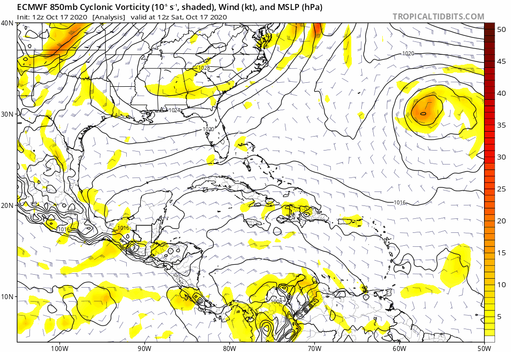
Euro is like what TC? Continues to show nothing but a weak area of vorticity through 144 hours
0 likes
-
StPeteMike

- Category 2

- Posts: 657
- Joined: Thu Jun 07, 2018 11:26 pm
Re: Possible SW Caribbean Development
chaser1 wrote:In spite of the early and consistent development signals by both the GFS and Para, the bottom line is that both have simply pumped out model solutions based on a storm that at minimum they have jumped the gun on. Perhaps the ICON & UK might suggest a bit of increased model consensus? As bad as the EURO has been this year, any suggestion of significant development from it would lend some greater confidence of a west Caribbean storm likely to form. The fact that NHC has increased their longer range prediction up to 30% suggest an increased likelihood of eventual development but that doesn't mean that the end result will necessarily be anything anything stronger then a weak T.S. My low-confidence guess at this point would err toward a moderate to strong T.S. somewhere between the Yucatan channel & Isle of Pines around Oct. 25-28th
The models were totally off on Delta’s strength before Yucatán, even with a weaker storm before landfall. I don’t see anything that would prohibit the same kind of intensification that Delta experienced.
Where it decides to do so is the issue. Stays weak and moves further west before doing so means a high chance of Florida impacts.
2 likes
The above post is not official and should not be used as such. It is the opinion of the poster and may or may not be backed by sound meteorological data. It is not endorsed by any professional institution or storm2k.org. For official information, please refer to the NHC and NWS products.
-
Blown Away

- S2K Supporter
- Posts: 10253
- Joined: Wed May 26, 2004 6:17 am
Re: Possible SW Caribbean Development
gatorcane wrote:Euro is like what TC? Continues to show nothing but a weak area of vorticity through 144 hours
https://i.postimg.cc/2Sc4tVJT/ecmwf-uv850-vort-watl-fh0-144.gif
In fairness, the GFS is just starting to pull vorticity together @150 hrs... Euro has not shown much with this area so far...
0 likes
Hurricane Eye Experience: David 79, Irene 99, Frances 04, Jeanne 04, Wilma 05… Hurricane Brush Experience: Andrew 92, Erin 95, Floyd 99, Matthew 16, Irma 17, Ian 22, Nicole 22…
Re: Possible SW Caribbean Development
cp79 wrote:So I see the GFs is celebrating Happy Hour a little early today. That’s some insane run. As someone who lives in Tampa, all I have to say is thank god it’s a drunk run. No way that happens to us.
Tampa is model storm alley. Real storms....no so much. 1 year + 1 week = a full century absent a major (cat 3) impact. giddyup
0 likes
-
TheStormExpert
Re: Possible SW Caribbean Development
The only models that develop this now as of their 12z runs are the GFS, GFS-P, and the CMC. Significant development is now delayed until it leaves the north coast of Cuba and both the 12z GFS-P and CMC eject in NE so I’m disregarding the 12z GFS until I see some more consistency.
0 likes
Who is online
Users browsing this forum: AnnularCane, NotSparta, pepecool20 and 155 guests