
Trough of low pressure in Western Caribbean (Is Invest 95L)
Moderator: S2k Moderators
Forum rules

The posts in this forum are NOT official forecasts and should not be used as such. They are just the opinion of the poster and may or may not be backed by sound meteorological data. They are NOT endorsed by any professional institution or STORM2K. For official information, please refer to products from the National Hurricane Center and National Weather Service.
-
SouthFLTropics

- Category 5

- Posts: 4258
- Age: 50
- Joined: Thu Aug 14, 2003 8:04 am
- Location: Port St. Lucie, Florida
Re: Possible SW Caribbean Development
Between the crazy runs that the Para has shown over the last 24 hours and then the 18z GFS, I think a split between those solutions and the eject to the NE solutions may be the best long term prediction. I would not be surprised at all to see a track like Matthew, albeit coming out of the Caribbean further west than Matthew did.
0 likes
Fourth Generation Florida Native
Personal Storm History: David 79, Andrew 92, Erin 95, Floyd 99, Irene 99, Frances 04, Jeanne 04, Wilma 05, Matthew 16, Irma 17, Ian 22, Nicole 22, Milton 24
Personal Storm History: David 79, Andrew 92, Erin 95, Floyd 99, Irene 99, Frances 04, Jeanne 04, Wilma 05, Matthew 16, Irma 17, Ian 22, Nicole 22, Milton 24
-
gatorcane

- S2K Supporter

- Posts: 23708
- Age: 48
- Joined: Sun Mar 13, 2005 3:54 pm
- Location: Boca Raton, FL
Re: Possible SW Caribbean Development
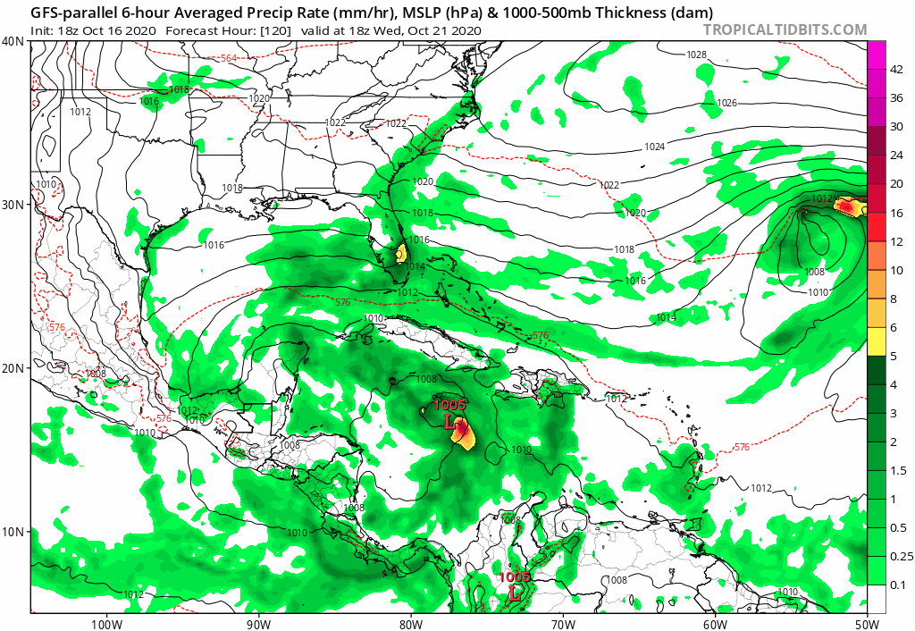
18Z GFS P headed north towards Florida. Note also that is just one week away:
0 likes
-
SouthFLTropics
- Category 5
- Posts: 4258
- Age: 50
- Joined: Thu Aug 14, 2003 8:04 am
- Location: Port St. Lucie, Florida
Re: Possible SW Caribbean Development
So the Para ends up ejecting it NE but not before jogging straight North through the Bahamas. This tells me that there is a potential for ridging to be there. Something to watch for on future runs.

0 likes
Fourth Generation Florida Native
Personal Storm History: David 79, Andrew 92, Erin 95, Floyd 99, Irene 99, Frances 04, Jeanne 04, Wilma 05, Matthew 16, Irma 17, Ian 22, Nicole 22, Milton 24
Personal Storm History: David 79, Andrew 92, Erin 95, Floyd 99, Irene 99, Frances 04, Jeanne 04, Wilma 05, Matthew 16, Irma 17, Ian 22, Nicole 22, Milton 24
-
StPeteMike

- Category 2

- Posts: 657
- Joined: Thu Jun 07, 2018 11:26 pm
Re: Possible SW Caribbean Development
The models that were forecasting a NE movement of a system a few days ago, be weak or strong, seem to be less confident about such a movement now. Agree with SouthFLTropics, think models are catching on to a stronger ridge.
0 likes
The above post is not official and should not be used as such. It is the opinion of the poster and may or may not be backed by sound meteorological data. It is not endorsed by any professional institution or storm2k.org. For official information, please refer to the NHC and NWS products.
-
SouthFLTropics
- Category 5
- Posts: 4258
- Age: 50
- Joined: Thu Aug 14, 2003 8:04 am
- Location: Port St. Lucie, Florida
Re: Possible SW Caribbean Development
Hurricane 5 of 1895 and Hurricane Fox of 1952 may also be good analogs for this system...


0 likes
Fourth Generation Florida Native
Personal Storm History: David 79, Andrew 92, Erin 95, Floyd 99, Irene 99, Frances 04, Jeanne 04, Wilma 05, Matthew 16, Irma 17, Ian 22, Nicole 22, Milton 24
Personal Storm History: David 79, Andrew 92, Erin 95, Floyd 99, Irene 99, Frances 04, Jeanne 04, Wilma 05, Matthew 16, Irma 17, Ian 22, Nicole 22, Milton 24
-
cp79
Re: Possible SW Caribbean Development
SouthFLTropics wrote:So the Para ends up ejecting it NE but not before jogging straight North through the Bahamas. This tells me that there is a potential for ridging to be there. Something to watch for on future runs.
https://i.imgur.com/Vn1USeG.gif
This is the scenario I’m most worried about for Tampa. If it stays with that north motion another 12 hours or so before the NE turn it rides that west coast up.
0 likes
-
otowntiger
- Category 5
- Posts: 1932
- Joined: Tue Aug 31, 2004 7:06 pm
Re: Possible SW Caribbean Development
gatorcane wrote:18Z GFS P headed north towards Florida. Note also that is just one week away:
https://i.postimg.cc/vmf8M6qb/gfsp-mslp-pcpn-watl-fh120-168.gif
And now the Para is the sensible one. Regardless I’m very skeptical as the two GFS models are on an island with this. Not only am I not convinced of their tracks and especially intensity, I’m not even convinced anything substantial comes of this at all. But of course we’ll see- I’ve clearly been wrong before. (Sticking with the bears, as per my usual).
0 likes
-
cp79
Re: Possible SW Caribbean Development
For those who do live in Tampa like me, just a reminder this is our time of year. The last major to hit the area directly was in 1921 which formed on October 20 in the very same area this is forecast to form.
https://en.m.wikipedia.org/wiki/1921_Ta ... _hurricane
https://en.m.wikipedia.org/wiki/1921_Ta ... _hurricane
2 likes
Re: Possible SW Caribbean Development
OuterBanker wrote:LOL, it we ever create a thread for bizarre models the 18z Oct 16 GFS would be number 1.
While 94L will become a harmless fish. This could be a threat. It has seemed to windshield wiper from fish to coast hugger.
But, we here have been very lucky and we should escape anything this year except we have had a bad omen.
Our elderly neighbor put her hurricane shutters early and left them up.
Today she had them taken down.
I am now concerned

Be strong...
2 likes

Re: Possible SW Caribbean Development
Yikes, that Para run is super close to a Cat 3 riding up the SEUS coast. It yet again has MH landfalls in Cuba and the Bahamas.
Regardless if Zeta impacts the US or not, it looks like it will be a very powerful and destructive storm to regions that have been battered by Category 5 landfalls within the last few years.
Regardless if Zeta impacts the US or not, it looks like it will be a very powerful and destructive storm to regions that have been battered by Category 5 landfalls within the last few years.
0 likes
Irene '11 Sandy '12 Hermine '16 5/15/2018 Derecho Fay '20 Isaias '20 Elsa '21 Henri '21 Ida '21
I am only a meteorology enthusiast who knows a decent amount about tropical cyclones. Look to the professional mets, the NHC, or your local weather office for the best information.
I am only a meteorology enthusiast who knows a decent amount about tropical cyclones. Look to the professional mets, the NHC, or your local weather office for the best information.
-
TheStormExpert
Re: Possible SW Caribbean Development
SouthFLTropics wrote:So the Para ends up ejecting it NE but not before jogging straight North through the Bahamas. This tells me that there is a potential for ridging to be there. Something to watch for on future runs.
https://i.imgur.com/Vn1USeG.gif
I can’t help but laugh at how many runs in the past day or two the GFS-P has shown this system swerving and avoiding Florida. Is as if the Florida Hurricane Shield really exists.
1 likes
-
skyline385

- Category 5
- Posts: 2728
- Age: 35
- Joined: Wed Aug 26, 2020 11:15 pm
- Location: Houston TX

Re: Possible SW Caribbean Development
skyline385 wrote:lots of dispersion in 18Z GEFS
https://cdn.discordapp.com/attachments/485131981043269632/766845008174907402/gefs_cyclones_carib_360.png
That gives me double vision just lookin at it...
0 likes
-
SFLcane

- S2K Supporter
- Posts: 10281
- Age: 48
- Joined: Sat Jun 05, 2010 1:44 pm
- Location: Lake Worth Florida
Re: Possible SW Caribbean Development
[Youtube][/Youtube]
Again for what it’s worth the GEFS has been nothing short of excellent this season with its long range forecast. When you see a signal such as what it’s been showing for days and days look out. Nhc did note at 8pm a broad low is now expected to form down there so look for things to get going sometime this weekend. Is this one we should watch? I have had this feeling all year that Florida will not escape this prolific landfalling season. Let’s hope i am wrong.
gatorcane wrote:Any chance the GFS hurricane is a phantom? I just really wonder since really the GFS and the GFS-P are the only two models showing a significant hurricane. I know it is the NAVGEM but barely anything still and usually the model gives false positives where we see the model bombing out something only for it not to happen. Only the CMC has something of moderate significance but really only once out of the Caribbean.
https://i.postimg.cc/6qwyFhtk/2-E602-F7-A-EC9-C-47-A1-A261-EF5923-FF232-D.gif
Again for what it’s worth the GEFS has been nothing short of excellent this season with its long range forecast. When you see a signal such as what it’s been showing for days and days look out. Nhc did note at 8pm a broad low is now expected to form down there so look for things to get going sometime this weekend. Is this one we should watch? I have had this feeling all year that Florida will not escape this prolific landfalling season. Let’s hope i am wrong.
1 likes
Re: Possible SW Caribbean Development
Something to note is that the GFS-Para’s “launching point” for Zeta is on the South American coast and not within the SW Caribbean, putting it outside of the NHC’s development bubble. A further west development would give Zeta a lot more time over 29.5-30.5C SSTs and high OHC, meaning the ceiling will be insanely high assuming dry air and shear won’t be problems.
1 likes
Irene '11 Sandy '12 Hermine '16 5/15/2018 Derecho Fay '20 Isaias '20 Elsa '21 Henri '21 Ida '21
I am only a meteorology enthusiast who knows a decent amount about tropical cyclones. Look to the professional mets, the NHC, or your local weather office for the best information.
I am only a meteorology enthusiast who knows a decent amount about tropical cyclones. Look to the professional mets, the NHC, or your local weather office for the best information.
-
SFLcane
- S2K Supporter
- Posts: 10281
- Age: 48
- Joined: Sat Jun 05, 2010 1:44 pm
- Location: Lake Worth Florida
Re: Possible SW Caribbean Development
18z gfs reminded me of hurricane King which slammed into SFL on October 18, 1950

0 likes
-
otowntiger
- Category 5
- Posts: 1932
- Joined: Tue Aug 31, 2004 7:06 pm
Re: Possible SW Caribbean Development
skyline385 wrote:lots of dispersion in 18Z GEFS
https://cdn.discordapp.com/attachments/485131981043269632/766845008174907402/gefs_cyclones_carib_360.png
Vast majority of those miss Florida. Pretty amazing.
0 likes


-
Hurricaneman

- Category 5
- Posts: 7404
- Age: 45
- Joined: Tue Aug 31, 2004 3:24 pm
- Location: central florida
Re: Possible SW Caribbean Development
Looks as though there may be a broad low forming in the western Caribbean but has little to no convection at the moment but could start sustaining convection in the next few days
0 likes
Who is online
Users browsing this forum: hurricanes1234 and 102 guests