Trough of low pressure in Western Caribbean (Is Invest 95L)
Moderator: S2k Moderators
Forum rules

The posts in this forum are NOT official forecasts and should not be used as such. They are just the opinion of the poster and may or may not be backed by sound meteorological data. They are NOT endorsed by any professional institution or STORM2K. For official information, please refer to products from the National Hurricane Center and National Weather Service.

Re: Possible SW Caribbean Development
Model results for Zeta are likely to become way more variable now that most models have picked up on the likelihood of Epsilon developing. We’ll need to wait for Epsilon to develop this weekend to have a better idea on how it would weaken the ridge and/or influence Zeta.
2 likes
Irene '11 Sandy '12 Hermine '16 5/15/2018 Derecho Fay '20 Isaias '20 Elsa '21 Henri '21 Ida '21
I am only a meteorology enthusiast who knows a decent amount about tropical cyclones. Look to the professional mets, the NHC, or your local weather office for the best information.
I am only a meteorology enthusiast who knows a decent amount about tropical cyclones. Look to the professional mets, the NHC, or your local weather office for the best information.
-
SFLcane

- S2K Supporter

- Posts: 10281
- Age: 48
- Joined: Sat Jun 05, 2010 1:44 pm
- Location: Lake Worth Florida
Re: Possible SW Caribbean Development
12z Canadian... 

Last edited by SFLcane on Thu Oct 15, 2020 11:49 am, edited 1 time in total.
0 likes
Re: Possible SW Caribbean Development
Someone please explain how the 12z ICON develops Zeta in the SE Gulf.
0 likes
Irene '11 Sandy '12 Hermine '16 5/15/2018 Derecho Fay '20 Isaias '20 Elsa '21 Henri '21 Ida '21
I am only a meteorology enthusiast who knows a decent amount about tropical cyclones. Look to the professional mets, the NHC, or your local weather office for the best information.
I am only a meteorology enthusiast who knows a decent amount about tropical cyclones. Look to the professional mets, the NHC, or your local weather office for the best information.
-
AutoPenalti
- Category 5

- Posts: 4091
- Age: 29
- Joined: Mon Aug 17, 2015 4:16 pm
- Location: Ft. Lauderdale, Florida
Re: Possible SW Caribbean Development
This thread about to drop dead in a couple of minutes...
0 likes
The posts in this forum are NOT official forecasts and should not be used as such. They are just the opinion of the poster and may or may not be backed by sound meteorological data. They are NOT endorsed by any professional institution or STORM2K. For official information, please refer to products from the NHC and NWS.
Model Runs Cheat Sheet:
GFS (5:30 AM/PM, 11:30 AM/PM)
HWRF, GFDL, UKMET, NAVGEM (6:30-8:00 AM/PM, 12:30-2:00 AM/PM)
ECMWF (1:45 AM/PM)
TCVN is a weighted averaged
-
CourierPR

- Category 5
- Posts: 1336
- Age: 72
- Joined: Tue Aug 31, 2004 7:53 pm
- Location: Pompano Beach, Florida
Re: Possible SW Caribbean Development
gatorcane wrote:This is the farthest east run yet, encouraging run for us in Florida
If it were to verify, and that is highly questionable at this point.
2 likes
-
TheStormExpert
Re: Possible SW Caribbean Development
aspen wrote:Someone please explain how the 12z ICON develops Zeta in the SE Gulf.
The ICON is a lost cause!

0 likes
-
TheStormExpert
Re: Possible SW Caribbean Development
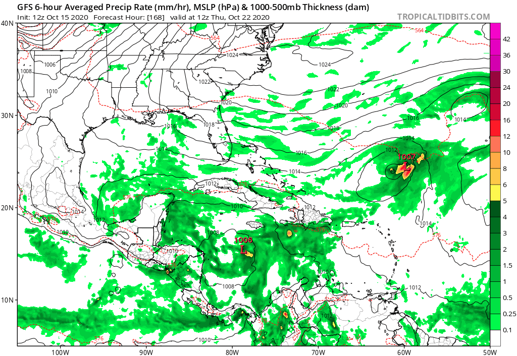
gatorcane wrote:This is the farthest east run yet, encouraging run for us in Florida:
https://i.postimg.cc/Qdpw3skv/gfs-mslp-pcpn-watl-fh168-264.gif
Most runs have been this far east, but the GFS has been MOSTLY consistent on a storm or hurricane ejecting NE across East or Central Cuba. Last nights 18z run was an outlier. Having a -NAO lends this more credence in my opinion.
0 likes
Re: Possible SW Caribbean Development
I feel that this system is definitely something to watch in the coming days, if I lived in Florida. Wouldn't a system that forms down there, track towards Florida, perhaps influenced by a front?
0 likes
-
TheStormExpert
Re: Possible SW Caribbean Development
underthwx wrote:I feel that this system is definitely something to watch in the coming days, if I lived in Florida. Wouldn't a system that forms down there, track towards Florida, perhaps influenced by a front?
Unless it can get into the the far NW Caribbean before ejecting NE and threat to Florida seems limited. Besides the North Atlantic Oscillation is negative as I’ve been saying so an escape route through Cuba and The Bahamas seems more plausible. We’re also more likely today than a few days ago to have a weakness form thanks to the Subtropical area that could grab the name Epsilon.
0 likes
Re: Possible SW Caribbean Development
A late season storm missing florida to the east and south is very common (think Michelle 2001). From the start I have suspected that any risk to the state is more likely to be weighted south and east...but the higher risk is likely to reside east and south of the state. We shall see but that is definitely an option. Post Delta... it's become easy to not worry so much about cane season unless and until there is compelling evidence to the contrary. So far that philosophy is working nicely but we will keep checking in.
1 likes
-
Loveweather12
- Tropical Storm

- Posts: 136
- Joined: Thu Aug 20, 2020 2:37 pm
Re: Possible SW Caribbean Development
You know I’m going to laugh if this storm moves closer or threatens FL & I live in FL. The way most on here are discounting a storm & telling people to come back in June when a Low hasn’t even formed yet frankly surprises me seeing the seniority on This page. Shouldn’t we know by now that storms & models change drastically. Wow.. we can’t let our guard down. Keep saying the so called shields are up & watch a hurricane make landfall in places some are saying won’t happen forever. Wow I’m shocked but maybe it’s just me.
6 likes
-
HurricaneEnzo

- Category 2

- Posts: 744
- Joined: Wed Mar 14, 2018 12:18 pm
- Location: Newport, NC (Hurricane Alley)
Re: Possible SW Caribbean Development
aspen wrote:Someone please explain how the 12z ICON develops Zeta in the SE Gulf.
The answer is in the question
0 likes
Bertha 96' - Fran 96' - Bonnie 98' - Dennis 99' - Floyd 99' - Isabel 03' - Alex 04' - Ophelia 05' - Irene 11' - Arthur 14' - Matthew 16' - Florence 18' - Dorian 19' - Isaias 20' (countless other tropical storms and Hurricane swipes)
I am not a Professional Met just an enthusiast. Get your weather forecasts from the Pros!
I am not a Professional Met just an enthusiast. Get your weather forecasts from the Pros!

Re: Possible SW Caribbean Development
I think the CMC is the most reasonable. I think GFS is ramping it up too quickly.
12z GEFS trending weaker and more west.

12z GEFS trending weaker and more west.
Last edited by blp on Thu Oct 15, 2020 12:28 pm, edited 1 time in total.
2 likes
The following post is NOT an official forecast and should not be used as such. It is just the opinion of the poster and may or may not be backed by sound meteorological data. It is NOT endorsed by any professional institution including storm2k.org For Official Information please refer to the NHC and NWS products.
-
CourierPR
- Category 5
- Posts: 1336
- Age: 72
- Joined: Tue Aug 31, 2004 7:53 pm
- Location: Pompano Beach, Florida
Re: Possible SW Caribbean Development
Loveweather12 wrote:You know I’m going to laugh if this storm moves closer or threatens FL & I live in FL. The way most on here are discounting a storm & telling people to come back in June when a Low hasn’t even formed yet frankly surprises me seeing the seniority on This page. Shouldn’t we know by now that storms & models change drastically. Wow.. we can’t let our guard down. Keep saying the so called shields are up & watch a hurricane make landfall in places some are saying won’t happen forever. Wow I’m shocked but maybe it’s just me.
I agree with you. Here we are on the 15th with some predicting a clear miss for Florida from a storm that hasn't formed yet but may form around the 19th or 20th. This and the overuse of the word "bury" boggles my mind.
2 likes


-
Craters
- Category 1

- Posts: 428
- Joined: Sat Aug 24, 2013 2:34 pm
- Location: Alvin, TX (south of Houston)
Re: Possible SW Caribbean Development
That track reminds me of the flying saucer pushing the Washington Monument around in "Mars Attacks!"
0 likes
Nothing that I post here should ever be treated as a forecast or anything resembling one. Please check with your local NWS office or the NHC for forecasts, watches, and warnings.
-
plasticup
Re: Possible SW Caribbean Development
AutoPenalti wrote:This thread about to drop dead in a couple of minutes...
What do you mean?
0 likes
-
cycloneye

- Admin

- Posts: 149735
- Age: 69
- Joined: Thu Oct 10, 2002 10:54 am
- Location: San Juan, Puerto Rico
Re: Possible SW Caribbean Development
2 PM TWO:
A broad area of low pressure could form by early next week over
the southwestern Caribbean Sea. Some gradual development of the
system will be possible thereafter while it moves slowly
northwestward.
* Formation chance through 48 hours...low...near 0 percent.
* Formation chance through 5 days...low...20 percent.
the southwestern Caribbean Sea. Some gradual development of the
system will be possible thereafter while it moves slowly
northwestward.
* Formation chance through 48 hours...low...near 0 percent.
* Formation chance through 5 days...low...20 percent.
0 likes
Visit the Caribbean-Central America Weather Thread where you can find at first post web cams,radars
and observations from Caribbean basin members Click Here
and observations from Caribbean basin members Click Here

Re: Possible SW Caribbean Development
HurricaneEnzo wrote:aspen wrote:Someone please explain how the 12z ICON develops Zeta in the SE Gulf.
The answer is in the question
Its develops it from 93L.
0 likes
-
AutoPenalti
- Category 5
- Posts: 4091
- Age: 29
- Joined: Mon Aug 17, 2015 4:16 pm
- Location: Ft. Lauderdale, Florida
Re: Possible SW Caribbean Development
plasticup wrote:AutoPenalti wrote:This thread about to drop dead in a couple of minutes...
What do you mean?
Check the posts above you. The same people seem to reiterate the same thing. Can't verify something that isn't there yet, hell, even the upper level environment isn't set in stone.. We are just gambling at this point but normally when the threat to Florida is "off", or when people are "breathing a sigh of relief" we get that drop in attention.
1 likes
The posts in this forum are NOT official forecasts and should not be used as such. They are just the opinion of the poster and may or may not be backed by sound meteorological data. They are NOT endorsed by any professional institution or STORM2K. For official information, please refer to products from the NHC and NWS.
Model Runs Cheat Sheet:
GFS (5:30 AM/PM, 11:30 AM/PM)
HWRF, GFDL, UKMET, NAVGEM (6:30-8:00 AM/PM, 12:30-2:00 AM/PM)
ECMWF (1:45 AM/PM)
TCVN is a weighted averaged
Who is online
Users browsing this forum: Blown Away and 427 guests