ATL: DELTA - Post-Tropical - Discussion
Moderator: S2k Moderators
-
Blown Away

- S2K Supporter

- Posts: 10253
- Joined: Wed May 26, 2004 6:17 am
Re: ATL: Potential Tropical Cyclone 26 - Discussion
Looking at Gamma & 26L’s 120-144 position for the TVCN on the early 00z guidance, they both arrive at the LA coast about the same time... Thinking that’s unlikely so something will give...
2 likes
Hurricane Eye Experience: David 79, Irene 99, Frances 04, Jeanne 04, Wilma 05… Hurricane Brush Experience: Andrew 92, Erin 95, Floyd 99, Matthew 16, Irma 17, Ian 22, Nicole 22…

Re: ATL: Potential Tropical Cyclone 26 - Discussion
Blown Away wrote:Looking at Gamma & 26L’s 120-144 position for the TVCN on the early 00z guidance, they both arrive at the LA coast about the same time... Thinking that’s unlikely so something will give...
It looks like the Gamma TVCN is picking up on 26's low as it weakens since they are so close.
1 likes
Kendall -> SLO -> PBC
Memorable Storms: Katrina (for its Florida landfall...) Wilma Matthew Irma
Memorable Storms: Katrina (for its Florida landfall...) Wilma Matthew Irma

-
Blown Away
- S2K Supporter
- Posts: 10253
- Joined: Wed May 26, 2004 6:17 am
Re: ATL: Potential Tropical Cyclone 26 - Discussion
Ubuntwo wrote:Blown Away wrote:Looking at Gamma & 26L’s 120-144 position for the TVCN on the early 00z guidance, they both arrive at the LA coast about the same time... Thinking that’s unlikely so something will give...
It looks like the Gamma TVCN is picking up on 26's low as it weakens since they are so close.
The 00z early intensity guidance keeps Gamma a moderate TS through that period, so at least it’s not showing remnant low.
0 likes
Hurricane Eye Experience: David 79, Irene 99, Frances 04, Jeanne 04, Wilma 05… Hurricane Brush Experience: Andrew 92, Erin 95, Floyd 99, Matthew 16, Irma 17, Ian 22, Nicole 22…
Re: ATL: Potential Tropical Cyclone 26 - Discussion
NHC increased the peak forecast to 90 kts
4 likes

Re: ATL: Potential Tropical Cyclone 26 - Discussion
26 TD’s is insane. I guess this will make 25th named storm (21 + 4).
6 likes
-
SconnieCane
- Category 5

- Posts: 1013
- Joined: Thu Aug 02, 2018 5:29 pm
- Location: Madison, WI
Re: ATL: TWENTY-SIX - Tropical Depression - Discussion
Here we go boys...a bit ahead of schedule I think. 
0 likes
Re: ATL: TWENTY-SIX - Tropical Depression - Discussion
SconnieCane wrote:Here we go boys...a bit ahead of schedule I think.
Not a good thing...the sooner this develops an organized inner core, the more time it has to explode into something big.
0 likes
-
ElectricStorm

- Category 5
- Posts: 5140
- Age: 25
- Joined: Tue Aug 13, 2019 11:23 pm
- Location: Norman, OK
Re: ATL: TWENTY-SIX - Tropical Depression - Discussion
NHC has it strengthening to 105mph in the gulf now, not weakening. If 26 gets intense before entering the gulf there may not be a whole lot putting the intensity in check until it reaches the cooler coastal waters. But I wouldn't think that would do a whole lot to it considering it's not going to be anything like Sally stalling on the coast. Seems like every update on this system has me even more concerned...
0 likes
B.S Meteorology, University of Oklahoma '25
Please refer to the NHC, NWS, or SPC for official information.
Please refer to the NHC, NWS, or SPC for official information.
Re: ATL: TWENTY-SIX - Tropical Depression - Discussion
The dreaded classic la nina October pattern for a powerful cyclone in the Western Carribean. The theme this year has been storms coming in twos. A weak storm followed by a powerful one. That's an interesting thing to research. Why do storms come in twos?
3 likes
Re: ATL: TWENTY-SIX - Tropical Depression - Discussion
The thing I'd be worried about most is a slowdown or stall around the yucatan channel, because that would allow a stronger storm hitting Florida and maybe a nor'easter hybrid storm up the east coast.
0 likes
Re: ATL: TWENTY-SIX - Tropical Depression - Discussion
shah83 wrote:The thing I'd be worried about most is a slowdown or stall around the yucatan channel, because that would allow a stronger storm hitting Florida and maybe a nor'easter hybrid storm up the east coast.
I'm getting worried about a Wilma type set up.
1 likes
-
EquusStorm
- Category 5
- Posts: 1649
- Age: 35
- Joined: Thu Nov 07, 2013 1:04 pm
- Location: Jasper, AL
- Contact:
Re: ATL: TWENTY-SIX - Tropical Depression - Discussion
Boy this thing looks ominous tonight. No guarantee that structure holds at all, but if it doesn't hiccup until it hits the Gulf someone is in for a rough time.
2 likes
Colors of lost purpose on the canvas of irrelevance
Not a meteorologist, in fact more of an idiot than anything. You should probably check with the NHC or a local NWS office for official information.
Not a meteorologist, in fact more of an idiot than anything. You should probably check with the NHC or a local NWS office for official information.

Re: ATL: INVEST 92L - Discussion
underthwx wrote:chaser1 wrote:underthwx wrote:Looks like the only certainty with 92L....is uncertainty for the time being...to me it seems that whatever evolves from this system, would occur in the Eastern Gulf?....are there not cold fronts pushing any systems in that general direction?...
Naw, not really. Seems like there's a shortwave impulse dipping south of the Great Lakes around the 50-60 hr.s time range but the flow is very progressive and this doesn't really do much to break down the mid level ridging over Florida and Eastern GOM. 'Course if this were the same set up in the middle of the MDR, i'd bet we'd see 92L shoot northward into the decaying ridge faster then 100 chain-saw's pushing through a beaver dam LOL. Now, interestingly the GFS long range (around Oct. 14-18) does depict a strong and very deep short wave trough that extends south to the NW GOM and appears to progress east over time. This looks like that set up that would need to keep Cuba and Florida on it's toes for any potential W. Caribbean systems that would likely track primarily northward in response to deep layer steering. Long way off though and it'll remain to be seen if this trough and related cold front will verify (let along whether any developing TC is in place to our south.
I could not ask for a better informational response than than that chaser.....thank you for that...
You're most certainly welcome
1 likes
Andy D
(For official information, please refer to the NHC and NWS products.)
(For official information, please refer to the NHC and NWS products.)
-
ElectricStorm
- Category 5
- Posts: 5140
- Age: 25
- Joined: Tue Aug 13, 2019 11:23 pm
- Location: Norman, OK
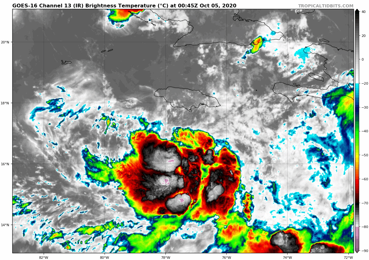
Re: ATL: TWENTY-SIX - Tropical Depression - Discussion
Already some <-80 C cloud tops in there... if those wrap around the center and an eye clears out...

0 likes
B.S Meteorology, University of Oklahoma '25
Please refer to the NHC, NWS, or SPC for official information.
Please refer to the NHC, NWS, or SPC for official information.

Re: ATL: TWENTY-SIX - Tropical Depression - Discussion
Fancy1001 wrote:shah83 wrote:The thing I'd be worried about most is a slowdown or stall around the yucatan channel, because that would allow a stronger storm hitting Florida and maybe a nor'easter hybrid storm up the east coast.
I'm getting worried about a Wilma type set up.
I would not be surprised.
0 likes
-
AutoPenalti
- Category 5
- Posts: 4091
- Age: 29
- Joined: Mon Aug 17, 2015 4:16 pm
- Location: Ft. Lauderdale, Florida
Re: ATL: TWENTY-SIX - Tropical Depression - Discussion
Fancy1001 wrote:shah83 wrote:The thing I'd be worried about most is a slowdown or stall around the yucatan channel, because that would allow a stronger storm hitting Florida and maybe a nor'easter hybrid storm up the east coast.
I'm getting worried about a Wilma type set up.
A Wilma setup would require a stronger trough and we aren’t seeing that at the moment.
2 likes
The posts in this forum are NOT official forecasts and should not be used as such. They are just the opinion of the poster and may or may not be backed by sound meteorological data. They are NOT endorsed by any professional institution or STORM2K. For official information, please refer to products from the NHC and NWS.
Model Runs Cheat Sheet:
GFS (5:30 AM/PM, 11:30 AM/PM)
HWRF, GFDL, UKMET, NAVGEM (6:30-8:00 AM/PM, 12:30-2:00 AM/PM)
ECMWF (1:45 AM/PM)
TCVN is a weighted averaged

Re: ATL: TWENTY-SIX - Tropical Depression - Discussion
Some of the shelf waters are already at 24 degrees, wouldn't this cause Delta to rapidly weaken as it approached landfall?
1 likes
-
ElectricStorm
- Category 5
- Posts: 5140
- Age: 25
- Joined: Tue Aug 13, 2019 11:23 pm
- Location: Norman, OK
Re: ATL: TWENTY-SIX - Tropical Depression - Discussion
tiger_deF wrote:Some of the shelf waters are already at 24 degrees, wouldn't this cause Delta to rapidly weaken as it approached landfall?
Hopefully. I think it's supposed to move pretty quickly as it comes in so it may not hurt it too much.
1 likes
B.S Meteorology, University of Oklahoma '25
Please refer to the NHC, NWS, or SPC for official information.
Please refer to the NHC, NWS, or SPC for official information.
Who is online
Users browsing this forum: No registered users and 67 guests