SFLcane wrote:12z CMC with an intensifying cyclone in the northwestern Caribbean Sea moving into the GOM.
https://i.imgur.com/xydDjEf.gif
First sub-1000mb run I’ve seen of the cmc in a while
Moderator: S2k Moderators


SFLcane wrote:12z CMC with an intensifying cyclone in the northwestern Caribbean Sea moving into the GOM.
https://i.imgur.com/xydDjEf.gif


StPeteMike wrote:I’ll go and bet $20 models will swing back to a stronger system in the NW Caribbean for the remainder of the time.


chaser1 wrote:StPeteMike wrote:I’ll go and bet $20 models will swing back to a stronger system in the NW Caribbean for the remainder of the time.
I tend to agree with your thinking for now but with a caveat that beginning this Friday, the windshield wipers all shift back toward weaker and little more than a minimal to moderate T.S. (or maybe little more then a wave of low pressure) sliding northeast over S. Fla.)

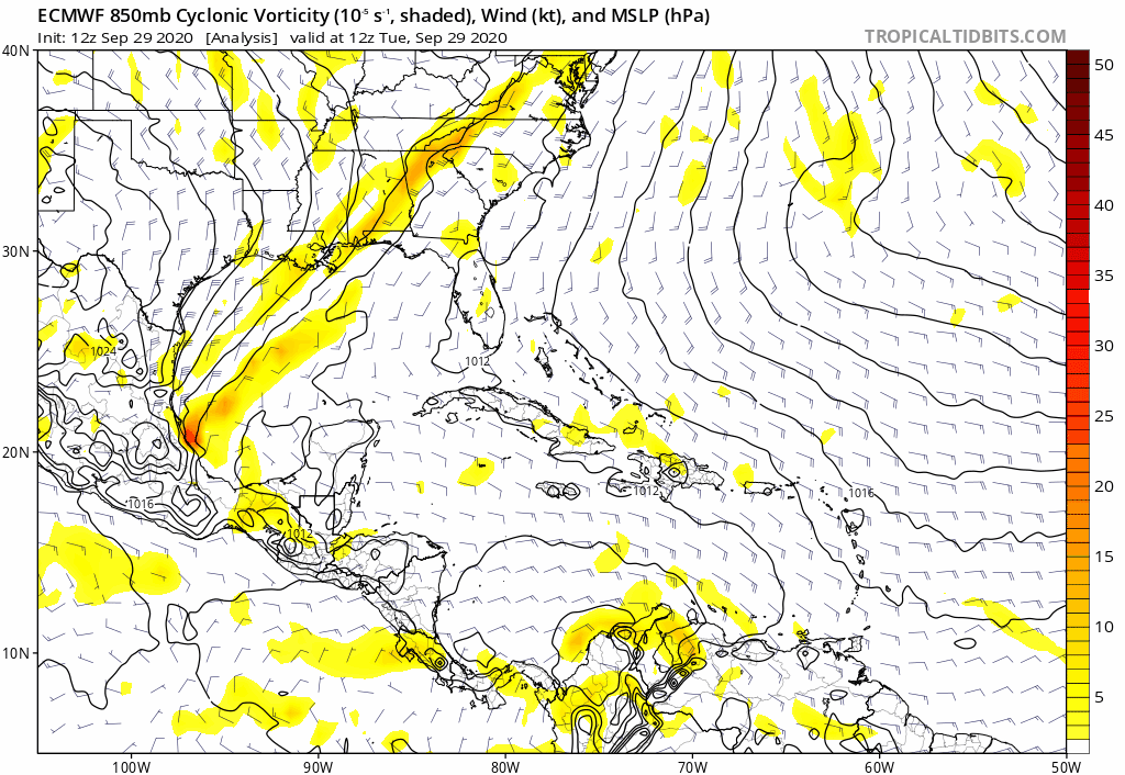
gatorcane wrote:12 Euro animation. Consensus of the two big models is buried into the Yucatan / Central America:
https://i.postimg.cc/yxY0114C/ecmwf-uv850-vort-watl-fh0-168.gif
gatorcane wrote:12 Euro animation. Consensus of the two big models is buried into the Yucatan / Central America:
https://i.postimg.cc/yxY0114C/ecmwf-uv850-vort-watl-fh0-168.gif

AutoPenalti wrote:gatorcane wrote:12 Euro animation. Consensus of the two big models is buried into the Yucatan / Central America:
https://i.postimg.cc/yxY0114C/ecmwf-uv850-vort-watl-fh0-168.gif
No consensus here, lol ... just have to keep watching.

StPeteMike wrote:chaser1 wrote:StPeteMike wrote:I’ll go and bet $20 models will swing back to a stronger system in the NW Caribbean for the remainder of the time.
I tend to agree with your thinking for now but with a caveat that beginning this Friday, the windshield wipers all shift back toward weaker and little more than a minimal to moderate T.S. (or maybe little more then a wave of low pressure) sliding northeast over S. Fla.)
Totally understandable and that’s $20 I’ll lose.... I guess dropping it on the ground.... if I am wrong.


Blown Away wrote:https://i.imgur.com/WiZKPJO.gif
12z GFS-P... This run our hurricane turns SW in the GOM and goes into the BOC... Another strong TS moves up from the Central Caribbean on a Matthew type track...


Blown Away wrote:https://i.imgur.com/WiZKPJO.gif
12z GFS-P... This run our hurricane turns SW in the GOM and goes into the BOC... Another strong TS moves up from the Central Caribbean on a Matthew type track...
Emmett_Brown wrote:Consensus is in the eye of the beholder. At 120 hours, the GFS, GFS Para, Euro, CMC, NAV, Icon... all have a close low of varying degrees of intensity in the vicinity of the Yucatan or the Yucatan channel. Also support from ensembles. After 120 hours things diverge. This is a pretty strong signal considering that we don't have anything close to a defined system yet.
boca wrote:Our luck continues and going against climatology I’ll stay here and watch all the storms miss the peninsula in the safe zone.The panhandle is not under the deflector shield.
Users browsing this forum: bird and 273 guests


