SFLcane wrote:Evening view of tropical wave moving through the eastern Caribbean.
https://i.imgur.com/ivOm7Ex.gif
Looks very anemic, but not moving much either.
Moderator: S2k Moderators


SFLcane wrote:Evening view of tropical wave moving through the eastern Caribbean.
https://i.imgur.com/ivOm7Ex.gif


boca wrote:Looks like the tropical wave is moving north not west.
boca wrote:Looks like the tropical wave is moving north not west.

AutoPenalti wrote:boca wrote:Looks like the tropical wave is moving north not west.
Dying convection makes it seem that way.

SFLcane wrote:Para still going at it...
https://i.postimg.cc/LX6GWKmB/13-EAF5-B5-248-D-4070-AAAF-561-CAAA461-B0.jpg
SFLcane wrote:Para still going at it...
https://i.postimg.cc/LX6GWKmB/13-EAF5-B5-248-D-4070-AAAF-561-CAAA461-B0.jpg
SFLcane wrote:Para still going at it...
https://i.postimg.cc/LX6GWKmB/13-EAF5-B5-248-D-4070-AAAF-561-CAAA461-B0.jpg

otowntiger wrote:SFLcane wrote:Para still going at it...
https://i.postimg.cc/LX6GWKmB/13-EAF5-B5-248-D-4070-AAAF-561-CAAA461-B0.jpg
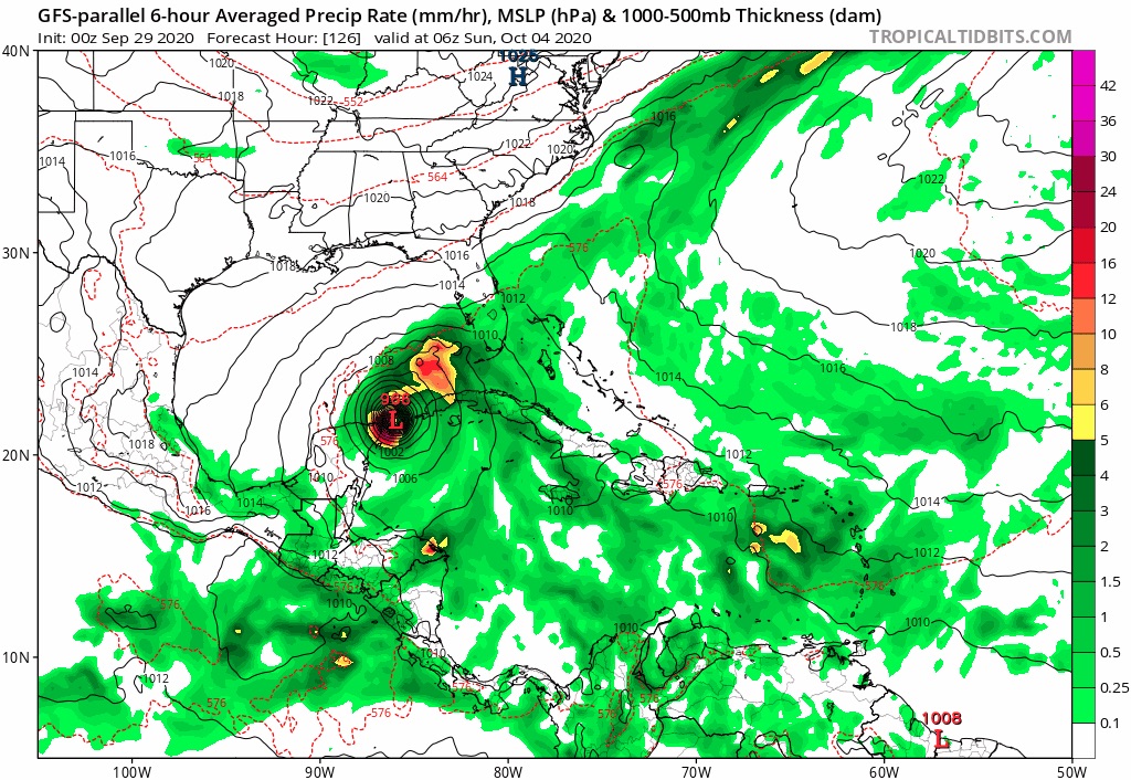
Well at least it’s consistent albeit a lone wolf at this time. That solution is possible, but less than likely due to what all the other ‘reliable’ models are presenting at this time and the fact that climatologically/historically most systems in that locale with the pending synoptic pattern would be a sheared weak t.s. At best. But obviously we’ve been fooled before, especially this season. So we must watch....


SFLcane wrote:GEFS still active this morning.
That’s under 5 days now
https://i.imgur.com/x0kZliH.png
https://i.imgur.com/9qMPBz1.png
AutoPenalti wrote:SFLcane wrote:GEFS still active this morning.
That’s under 5 days now
https://i.imgur.com/x0kZliH.png
https://i.imgur.com/9qMPBz1.png
...and further West.
Users browsing this forum: No registered users and 158 guests


