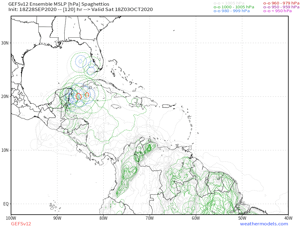
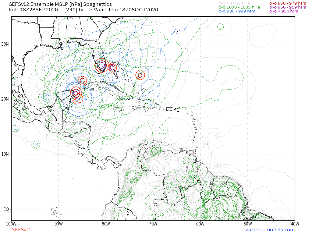
Tropical Wave in the West-Central Caribbean (Is Invest 91L)

This is the general tropical discussion area. Anyone can take their shot at predicting a storms path.

Moderator: S2k Moderators

Forum rules

The posts in this forum are NOT official forecasts and should not be used as such. They are just the opinion of the poster and may or may not be backed by sound meteorological data. They are NOT endorsed by any professional institution or STORM2K. For official information, please refer to products from the National Hurricane Center and National Weather Service.

Help Support Storm2K
Message
Author
User avatar
cycloneye
Admin
Admin
Posts: 145307
Age: 68
Joined: Thu Oct 10, 2002 10:54 am
Location: San Juan, Puerto Rico

Re: Possible development in Western Caribbean

#221 Postby cycloneye » Mon Sep 28, 2020 6:22 pm

Up to 50%.

Tropical Weather Outlook
NWS National Hurricane Center Miami FL
800 PM EDT Mon Sep 28 2020

For the North Atlantic...Caribbean Sea and the Gulf of Mexico:

A broad area of low pressure is expected to form over the western
Caribbean Sea in a few days. Environmental conditions are forecast
to be conducive for some development thereafter, and a tropical
depression could form late this week or this weekend while the
system moves slowly west-northwestward over the northwestern
Caribbean Sea.
* Formation chance through 48 hours...low...near 0 percent.
* Formation chance through 5 days...medium...50 percent.

$$
Forecaster Blake
8 likes   
Visit the Caribbean-Central America Weather Thread where you can find at first post web cams,radars
and observations from Caribbean basin members Click Here

WxEp
Tropical Depression
Tropical Depression
Posts: 71
Joined: Sat Sep 14, 2019 2:34 pm

Re: Possible development in Western Caribbean

#222 Postby WxEp » Mon Sep 28, 2020 6:27 pm

toad strangler wrote:Anyway, I think it was TheProfessor this morning who mentioned keeping a close eye on the thunderstorm complex SOUTH of Puerto Rico and if they collapse and the energy sticks close to the S coast down there then the GFS and crew may be on to something. If the storms persist and energy stays further N this could easily effect those solutions. Convection hasn't collapsed so we will have to watch this for sure to see if storms persist into the night. Could be the spark happening earlier than modeled. We'll see.


Looking at it on satellite, the energy seems to have migrated north throughout the day today. Recent trend seems to be for more energy S of PR and less energy near South America.
1 likes   
The posts in this forum are NOT official forecast and should not be used as such. They are just the opinion of the poster and may or may not be backed by sound meteorological data. They are NOT endorsed by any professional institution or STORM2K. For official information, refer to products from the National Hurricane Center and National Weather Service.

User avatar
toad strangler
S2K Supporter
S2K Supporter
Posts: 4543
Joined: Sun Jul 28, 2013 3:09 pm
Location: Earth
Contact:

Re: Possible development in Western Caribbean

#223 Postby toad strangler » Mon Sep 28, 2020 6:28 pm

gatorcane wrote:Quiet in this thread even after the GFS ran. Took a look and see why. Looks like it is actually a bit like the Euro driving this SW:

https://i.postimg.cc/446tpKhL/gfs-z850-vort-watl-fh0-168.gif


I'm not a big fan of the sit and spin for multiple days in a general area solutions. We'll see! I think the prudent thing to do here with this murky setup is be more skeptical than usual of solutions 96 hours plus out.
0 likes   

User avatar
SFLcane
S2K Supporter
S2K Supporter
Posts: 10163
Age: 47
Joined: Sat Jun 05, 2010 1:44 pm
Location: Lake Worth Florida

Re: Possible development in Western Caribbean: 8 PM TWO: Up to 50%

#224 Postby SFLcane » Mon Sep 28, 2020 6:32 pm

Image

Image
1 likes   

User avatar
toad strangler
S2K Supporter
S2K Supporter
Posts: 4543
Joined: Sun Jul 28, 2013 3:09 pm
Location: Earth
Contact:

Re: Possible development in Western Caribbean

#225 Postby toad strangler » Mon Sep 28, 2020 6:32 pm

WxEp wrote:
toad strangler wrote:Anyway, I think it was TheProfessor this morning who mentioned keeping a close eye on the thunderstorm complex SOUTH of Puerto Rico and if they collapse and the energy sticks close to the S coast down there then the GFS and crew may be on to something. If the storms persist and energy stays further N this could easily effect those solutions. Convection hasn't collapsed so we will have to watch this for sure to see if storms persist into the night. Could be the spark happening earlier than modeled. We'll see.


Looking at it on satellite, the energy seems to have migrated north throughout the day today. Recent trend seems to be for more energy S of PR and less energy near South America.


Yes, the far N section of this wave axis has all the punch for now. Soooo, we track ....

Image
6 likes   

User avatar
SFLcane
S2K Supporter
S2K Supporter
Posts: 10163
Age: 47
Joined: Sat Jun 05, 2010 1:44 pm
Location: Lake Worth Florida

Re: Possible development in Western Caribbean: 8 PM TWO: Up to 50%

#226 Postby SFLcane » Mon Sep 28, 2020 6:36 pm

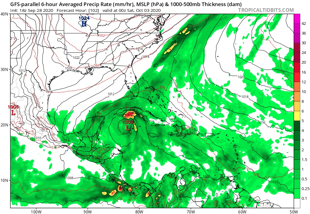
18z Para rolling... interested to see if it sticks to developing the northern axis of the tropical wave.

Edit: continues to do develop northern part although weaker starting off.

Image
Last edited by SFLcane on Mon Sep 28, 2020 7:26 pm, edited 2 times in total.
0 likes   

User avatar
ronjon
Category 5
Category 5
Posts: 4822
Joined: Fri Aug 19, 2005 5:17 pm
Location: Hernando Beach, FL

Re: Possible development in Western Caribbean

#227 Postby ronjon » Mon Sep 28, 2020 7:17 pm

Loveweather12 wrote:Nothing is set in stone. I don’t see how it goes SW when all I hear is troughs.

gatorcane wrote:Quiet in this thread even after the GFS ran. Took a look and looks like it is actually a bit like the Euro driving this SW:

https://i.postimg.cc/151BQhDT/gfs-z850-vort-watl-fh114-168.gif


Actually a piece of energy shunts off to the NE over central Florida on Sunday from the cyclone near the Yuc. This tells me that the stall may not be set in stone with GFS and perhaps parallel has the right idea. We'll see.
0 likes   

User avatar
aspen
Category 5
Category 5
Posts: 8818
Joined: Sat Oct 12, 2019 7:10 pm
Location: Connecticut, USA

Re: Possible development in Western Caribbean

#228 Postby aspen » Mon Sep 28, 2020 7:25 pm

18z parallel still has a further north track, although it’s weaker and less defined.
0 likes   
Irene '11 Sandy '12 Hermine '16 5/15/2018 Derecho Fay '20 Isaias '20 Elsa '21 Henri '21 Ida '21

I am only a meteorology enthusiast who knows a decent amount about tropical cyclones. Look to the professional mets, the NHC, or your local weather office for the best information.

User avatar
SFLcane
S2K Supporter
S2K Supporter
Posts: 10163
Age: 47
Joined: Sat Jun 05, 2010 1:44 pm
Location: Lake Worth Florida

Re: Possible development in Western Caribbean

#229 Postby SFLcane » Mon Sep 28, 2020 7:30 pm

aspen wrote:18z parallel still has a further north track, although it’s weaker and less defined.


Yeah it's gone Cat3-Cat2-Cat1-TS...

By tomorrow night might be a cumulus cloud.
4 likes   

User avatar
toad strangler
S2K Supporter
S2K Supporter
Posts: 4543
Joined: Sun Jul 28, 2013 3:09 pm
Location: Earth
Contact:

Re: Possible development in Western Caribbean

#230 Postby toad strangler » Mon Sep 28, 2020 7:33 pm

SFLcane wrote:
aspen wrote:18z parallel still has a further north track, although it’s weaker and less defined.


Yeah it's gone Cat3-Cat2-Cat1-TS...

By tomorrow night might be a cumulus cloud.


Intensity is the last thing to look at with these models this far out. #remember Hanna & Laura
4 likes   

User avatar
aspen
Category 5
Category 5
Posts: 8818
Joined: Sat Oct 12, 2019 7:10 pm
Location: Connecticut, USA

Re: Possible development in Western Caribbean

#231 Postby aspen » Mon Sep 28, 2020 7:40 pm

toad strangler wrote:
SFLcane wrote:
aspen wrote:18z parallel still has a further north track, although it’s weaker and less defined.


Yeah it's gone Cat3-Cat2-Cat1-TS...

By tomorrow night might be a cumulus cloud.


Intensity is the last thing to look at with these models.

I think the lowering intensity is due to the model being confused about the size of the wave, and which part will have the primary vorticity. It does have the northern part develop as before, but at 72 hours, the wave axis is ridiculously long — all the way from Panama to Jamaica — and prevents the system from quickly spinning up.
3 likes   
Irene '11 Sandy '12 Hermine '16 5/15/2018 Derecho Fay '20 Isaias '20 Elsa '21 Henri '21 Ida '21

I am only a meteorology enthusiast who knows a decent amount about tropical cyclones. Look to the professional mets, the NHC, or your local weather office for the best information.

User avatar
Blown Away
S2K Supporter
S2K Supporter
Posts: 10145
Joined: Wed May 26, 2004 6:17 am

Re: Possible development in Western Caribbean

#232 Postby Blown Away » Mon Sep 28, 2020 7:43 pm

aspen wrote:18z parallel still has a further north track, although it’s weaker and less defined.


It’s about the same as past few runs, not sure you can draw much conclusions when there is @5-10 mb swings at @150 hours... Continues to show a decent TS/Cat 1 into SW Fl...
1 likes   
Hurricane Eye Experience: David 79, Irene 99, Frances 04, Jeanne 04, Wilma 05... EYE COMING MY WAY IN 2024…
Hurricane Brush Experience: Andrew 92, Erin 95, Floyd 99, Matthew 16, Irma 17, Ian 22, Nicole 22…

psyclone
S2K Supporter
S2K Supporter
Posts: 4762
Joined: Wed Aug 24, 2005 9:04 pm
Location: palm harbor fl

Re: Possible development in Western Caribbean

#233 Postby psyclone » Mon Sep 28, 2020 7:47 pm

I'm leaning on the NHC for development odds rather than the manic model behavior. They're relentlessly increasing the odds. Now up to a coin toss. that's decent and trending up. Doesn't mean it will be significant. But considering the calendar and location...I'm definitely tuned in as anything can happen. we've had plenty of slow developing systems this year and systems that vastly exceeded initial expectations. this has been a year of close in sucker punches.
13 likes   

User avatar
GeneratorPower
S2K Supporter
S2K Supporter
Posts: 1648
Age: 45
Joined: Sun Dec 18, 2005 11:48 pm
Location: Huntsville, AL

Re: Possible development in Western Caribbean

#234 Postby GeneratorPower » Mon Sep 28, 2020 7:55 pm

psyclone wrote:I'm leaning on the NHC for development odds rather than the manic model behavior. They're relentlessly increasing the odds. Now up to a coin toss. that's decent and trending up. Doesn't mean it will be significant. But considering the calendar and location...I'm definitely tuned in as anything can happen. we've had plenty of slow developing systems this year and systems that vastly exceeded initial expectations. this has been a year of close in sucker punches.

The odds are increasing because there’s a 5 day fuse on the forecast. Time is getting closer so odds have to match. You’ll see the 48 hour odds increase soon, too.
2 likes   

User avatar
chaser1
S2K Supporter
S2K Supporter
Posts: 5464
Age: 64
Joined: Sat Oct 15, 2005 5:59 pm
Location: Longwood, Fl

Re: Possible development in Western Caribbean

#235 Postby chaser1 » Mon Sep 28, 2020 8:05 pm

This is purely conjecture but I'm assuming that the reason that the GFS-Para has backed off on intensity, is simply because it and other models are far better anticipating the near term post-front conditions that will be in place over Florida and the Gulf region. Suffice it to say, a quicker development and track toward Florida would suggest a weaker storm or minimal hurricane. On the other hand, the longer this system takes, the more time for cool dry conditions over Florida to be modified.
0 likes   
Andy D

(For official information, please refer to the NHC and NWS products.)

User avatar
Ubuntwo
Category 5
Category 5
Posts: 1406
Age: 31
Joined: Thu Oct 05, 2017 10:41 pm

Re: Possible development in Western Caribbean

#236 Postby Ubuntwo » Mon Sep 28, 2020 8:07 pm

1 likes   
Kendall -> SLO -> PBC

Memorable Storms: Katrina (for its Florida landfall...) Wilma Matthew Irma

TheStormExpert

Re: Possible development in Western Caribbean

#237 Postby TheStormExpert » Mon Sep 28, 2020 8:22 pm

aspen wrote:
toad strangler wrote:
SFLcane wrote:
Yeah it's gone Cat3-Cat2-Cat1-TS...

By tomorrow night might be a cumulus cloud.


Intensity is the last thing to look at with these models.

I think the lowering intensity is due to the model being confused about the size of the wave, and which part will have the primary vorticity. It does have the northern part develop as before, but at 72 hours, the wave axis is ridiculously long — all the way from Panama to Jamaica — and prevents the system from quickly spinning up.

We have three distinct different areas coming into the general Western Caribbean area. All competing for which will be dominant. Wouldn't surprise me when all is said and done if nothing much comes from this than a large monsoon-like gyre sloppy mess! :lol:
4 likes   

User avatar
Hurricaneman
Category 5
Category 5
Posts: 7351
Age: 45
Joined: Tue Aug 31, 2004 3:24 pm
Location: central florida

Re: Possible development in Western Caribbean

#238 Postby Hurricaneman » Mon Sep 28, 2020 8:42 pm

Looks like some low to mid level low near 69W 15N
0 likes   

User avatar
SFLcane
S2K Supporter
S2K Supporter
Posts: 10163
Age: 47
Joined: Sat Jun 05, 2010 1:44 pm
Location: Lake Worth Florida

Re: Possible development in Western Caribbean

#239 Postby SFLcane » Mon Sep 28, 2020 8:57 pm

Evening view of tropical wave moving through the eastern Caribbean.

Image
0 likes   

Loveweather12
Tropical Storm
Tropical Storm
Posts: 136
Joined: Thu Aug 20, 2020 2:37 pm

Re: Possible development in Western Caribbean

#240 Postby Loveweather12 » Mon Sep 28, 2020 8:58 pm

How might that affect the track etc?

SFLcane wrote:Evening view of tropical wave moving through the eastern Caribbean. Not much going on to it’s south.

https://i.imgur.com/ivOm7Ex.gif
0 likes   


Return to “Talkin' Tropics”

Who is online

Users browsing this forum: CyclonicFury, Google Adsense [Bot], NotSparta, sasha_B, StormWeather, StPeteMike, Ulf and 50 guests