Tropical Wave in the West-Central Caribbean (Is Invest 91L)

This is the general tropical discussion area. Anyone can take their shot at predicting a storms path.

Moderator: S2k Moderators

Forum rules

The posts in this forum are NOT official forecasts and should not be used as such. They are just the opinion of the poster and may or may not be backed by sound meteorological data. They are NOT endorsed by any professional institution or STORM2K. For official information, please refer to products from the National Hurricane Center and National Weather Service.

Help Support Storm2K
Message
Author
Nuno
Category 2
Category 2
Posts: 597
Joined: Fri Aug 30, 2019 8:35 am
Location: Coral Gables, FL

Re: Possible development in Western Caribbean

#201 Postby Nuno » Mon Sep 28, 2020 4:13 pm

TheStormExpert wrote:Maybe they’ll start decreasing development chances at 8pm if the GFS and GEFS even become less enthusiastic.

That or the models are screwing with our minds YET again. :x


Precisely why you shouldn't live or die by models. A tool, not the rule, etc
4 likes   
Andrew (1992), Irene (1999), Frances (2004), Katrina (2005), Wilma (2005), Fay (2008), Irma (2017), Eta (2020), Ian (2022)

Steve H.
Category 5
Category 5
Posts: 2146
Joined: Sat Oct 19, 2002 9:06 am
Location: Palm Bay, Florida

Re: Possible development in Western Caribbean

#202 Postby Steve H. » Mon Sep 28, 2020 4:25 pm

Yes, the EC does show it, albeit weak. Tis the season for the western Caribbean.
1 likes   

User avatar
ronjon
Category 5
Category 5
Posts: 4822
Joined: Fri Aug 19, 2005 5:17 pm
Location: Hernando Beach, FL

Re: Possible development in Western Caribbean

#203 Postby ronjon » Mon Sep 28, 2020 4:46 pm

Models really struggling now with cyclogeneis in the western Caribbean. Might take a few more model.cyc!es to nail things down..I think something will develop over the next 5 days...anyone's guess right now on systems strength and track. There seems to be indications of a large central american gyre developing and that always gives the models fits with storm development and movement.
7 likes   

Craters
Category 1
Category 1
Posts: 421
Joined: Sat Aug 24, 2013 2:34 pm
Location: Alvin, TX (south of Houston)

Re: Possible development in Western Caribbean

#204 Postby Craters » Mon Sep 28, 2020 4:53 pm

SFLcane wrote:Sure producing some convection today.

https://i.imgur.com/9HrBrFp.gif

...And take a peek at the blob in the Panama/Colombia corner, where GCANE was looking earlier...
0 likes   
Nothing that I post here should ever be treated as a forecast or anything resembling one. Please check with your local NWS office or the NHC for forecasts, watches, and warnings.

User avatar
toad strangler
S2K Supporter
S2K Supporter
Posts: 4543
Joined: Sun Jul 28, 2013 3:09 pm
Location: Earth
Contact:

Re: Possible development in Western Caribbean

#205 Postby toad strangler » Mon Sep 28, 2020 4:53 pm

ronjon wrote:Models really struggling now with cyclogeneis in the western Caribbean. Might take a few more model.cyc!es to nail things down..I think something will develop over the next 5 days...anyone's guess right now on systems strength and track. There seems to be indications of a large central american gyre developing and that always gives the models fits with storm development and movement.


It's a very complex region of the basin for the models to sort out. We might not know for relatively sure what will transpire until very close in to genesis or failed genesis time in the Yucatan general area. I'm watching that wave in real time to see how it behaves. It's been a overproducer all day as compared to what the models show.
1 likes   

User avatar
cheezyWXguy
Category 5
Category 5
Posts: 6108
Joined: Mon Feb 13, 2006 12:29 am
Location: Dallas, TX

Re: Possible development in Western Caribbean

#206 Postby cheezyWXguy » Mon Sep 28, 2020 4:54 pm

I feel like this is a scenario that is just too complex for models of course resolution to accurate analyze. The level of disagreement between models, as well as within the models run-to-run, seems unusually high for less than 5 days out, and even 7 days out seems like fantasyland at this point. You know it’s bad when the icon is the only one that can show the same solution 2 runs in a row.
0 likes   

User avatar
EquusStorm
Category 5
Category 5
Posts: 1649
Age: 34
Joined: Thu Nov 07, 2013 1:04 pm
Location: Jasper, AL
Contact:

Re: Possible development in Western Caribbean

#207 Postby EquusStorm » Mon Sep 28, 2020 4:54 pm

Ten named storms in September and 23 named storms into the season by the second half of said month, with NINE US landfalls including four hurricanes, entering a La Nina October with a favorable MJO headed this way and exceptionally high heat content in the WCarib and people STILL downcasting development? A'ight then I give up lol
16 likes   
Colors of lost purpose on the canvas of irrelevance

Not a meteorologist, in fact more of an idiot than anything. You should probably check with the NHC or a local NWS office for official information.

User avatar
aspen
Category 5
Category 5
Posts: 8818
Joined: Sat Oct 12, 2019 7:10 pm
Location: Connecticut, USA

Re: Possible development in Western Caribbean

#208 Postby aspen » Mon Sep 28, 2020 5:04 pm

Today’s “happy hour” GFS isn’t very happy. It’s another weak, late-developing system going into the Yucatán, without any of the crazy RI like seen in yesterday’s 18z run. I’m having more and more difficulty believing this slow development when the precursor wave has been doing so well.
1 likes   
Irene '11 Sandy '12 Hermine '16 5/15/2018 Derecho Fay '20 Isaias '20 Elsa '21 Henri '21 Ida '21

I am only a meteorology enthusiast who knows a decent amount about tropical cyclones. Look to the professional mets, the NHC, or your local weather office for the best information.

User avatar
cheezyWXguy
Category 5
Category 5
Posts: 6108
Joined: Mon Feb 13, 2006 12:29 am
Location: Dallas, TX

Re: Possible development in Western Caribbean

#209 Postby cheezyWXguy » Mon Sep 28, 2020 5:11 pm

aspen wrote:Today’s “happy hour” GFS isn’t very happy. It’s another weak, late-developing system going into the Yucatán, without any of the crazy RI like seen in yesterday’s 18z run. I’m having more and more difficulty believing this slow development when the precursor wave has been doing so well.

Agreed. The gfs insists on running it over the tip of Honduras in its formative stages, which precludes any rapid tightening of the circulation. If the wave tightens up north of South America, this scenario can largely be thrown out.
0 likes   

User avatar
SouthFLTropics
Category 5
Category 5
Posts: 4236
Age: 50
Joined: Thu Aug 14, 2003 8:04 am
Location: Port St. Lucie, Florida

Re: Possible development in Western Caribbean

#210 Postby SouthFLTropics » Mon Sep 28, 2020 5:14 pm

18z GFS is further North on the Yucatan and emerges into the GOM. This may spin up instead of getting buried like before.
0 likes   
Fourth Generation Florida Native

Personal Storm History: David 79, Andrew 92, Erin 95, Floyd 99, Irene 99, Frances 04, Jeanne 04, Wilma 05, Matthew 16, Irma 17, Ian 22, Nicole 22, Milton 24

User avatar
toad strangler
S2K Supporter
S2K Supporter
Posts: 4543
Joined: Sun Jul 28, 2013 3:09 pm
Location: Earth
Contact:

Re: Possible development in Western Caribbean

#211 Postby toad strangler » Mon Sep 28, 2020 5:20 pm

SouthFLTropics wrote:18z GFS is further North on the Yucatan and emerges into the GOM. This may spin up instead of getting buried like before.


Backing into the Yucatan once again.
0 likes   

User avatar
SouthFLTropics
Category 5
Category 5
Posts: 4236
Age: 50
Joined: Thu Aug 14, 2003 8:04 am
Location: Port St. Lucie, Florida

Re: Possible development in Western Caribbean

#212 Postby SouthFLTropics » Mon Sep 28, 2020 5:20 pm

toad strangler wrote:
SouthFLTropics wrote:18z GFS is further North on the Yucatan and emerges into the GOM. This may spin up instead of getting buried like before.


Backing into the Yucatan once again.


Yep, failure to launch again.
2 likes   
Fourth Generation Florida Native

Personal Storm History: David 79, Andrew 92, Erin 95, Floyd 99, Irene 99, Frances 04, Jeanne 04, Wilma 05, Matthew 16, Irma 17, Ian 22, Nicole 22, Milton 24

User avatar
toad strangler
S2K Supporter
S2K Supporter
Posts: 4543
Joined: Sun Jul 28, 2013 3:09 pm
Location: Earth
Contact:

Re: Possible development in Western Caribbean

#213 Postby toad strangler » Mon Sep 28, 2020 5:23 pm

So we are over a week out again on the 18z GFS with Low Pressure basically sitting on top of the Yucatan. ALL KINDS of changes can and probably will happen with this set up. It's a very murky forecast for sure.
0 likes   

User avatar
aspen
Category 5
Category 5
Posts: 8818
Joined: Sat Oct 12, 2019 7:10 pm
Location: Connecticut, USA

Re: Possible development in Western Caribbean

#214 Postby aspen » Mon Sep 28, 2020 5:39 pm

Shear is currently being analyzed at 15-20 kt by CIMSS, and it’s down to 5 kt further west. The wave will be moving into that lower shear over the next day, so if thunderstorms persist and aren’t entirely shear-driven, we might see it try to spin up tomorrow. Might.
3 likes   
Irene '11 Sandy '12 Hermine '16 5/15/2018 Derecho Fay '20 Isaias '20 Elsa '21 Henri '21 Ida '21

I am only a meteorology enthusiast who knows a decent amount about tropical cyclones. Look to the professional mets, the NHC, or your local weather office for the best information.

Loveweather12
Tropical Storm
Tropical Storm
Posts: 136
Joined: Thu Aug 20, 2020 2:37 pm

Re: Possible development in Western Caribbean

#215 Postby Loveweather12 » Mon Sep 28, 2020 5:51 pm

How might that affect a future track?
aspen wrote:Shear is currently being analyzed at 15-20 kt by CIMSS, and it’s down to 5 kt further west. The wave will be moving into that lower shear over the next day, so if thunderstorms persist and aren’t entirely shear-driven, we might see it try to spin up tomorrow. Might.
0 likes   

User avatar
Ubuntwo
Category 5
Category 5
Posts: 1406
Age: 31
Joined: Thu Oct 05, 2017 10:41 pm

Re: Possible development in Western Caribbean

#216 Postby Ubuntwo » Mon Sep 28, 2020 5:53 pm

Loveweather12 wrote:How might that affect a future track?
aspen wrote:Shear is currently being analyzed at 15-20 kt by CIMSS, and it’s down to 5 kt further west. The wave will be moving into that lower shear over the next day, so if thunderstorms persist and aren’t entirely shear-driven, we might see it try to spin up tomorrow. Might.

A storm that forms earlier would also strengthen earlier, and likely move poleward quicker. Could avoid significant interaction with the Yucatan as a result.
4 likes   
Kendall -> SLO -> PBC

Memorable Storms: Katrina (for its Florida landfall...) Wilma Matthew Irma

User avatar
gatorcane
S2K Supporter
S2K Supporter
Posts: 23691
Age: 47
Joined: Sun Mar 13, 2005 3:54 pm
Location: Boca Raton, FL

Re: Possible development in Western Caribbean

#217 Postby gatorcane » Mon Sep 28, 2020 6:10 pm

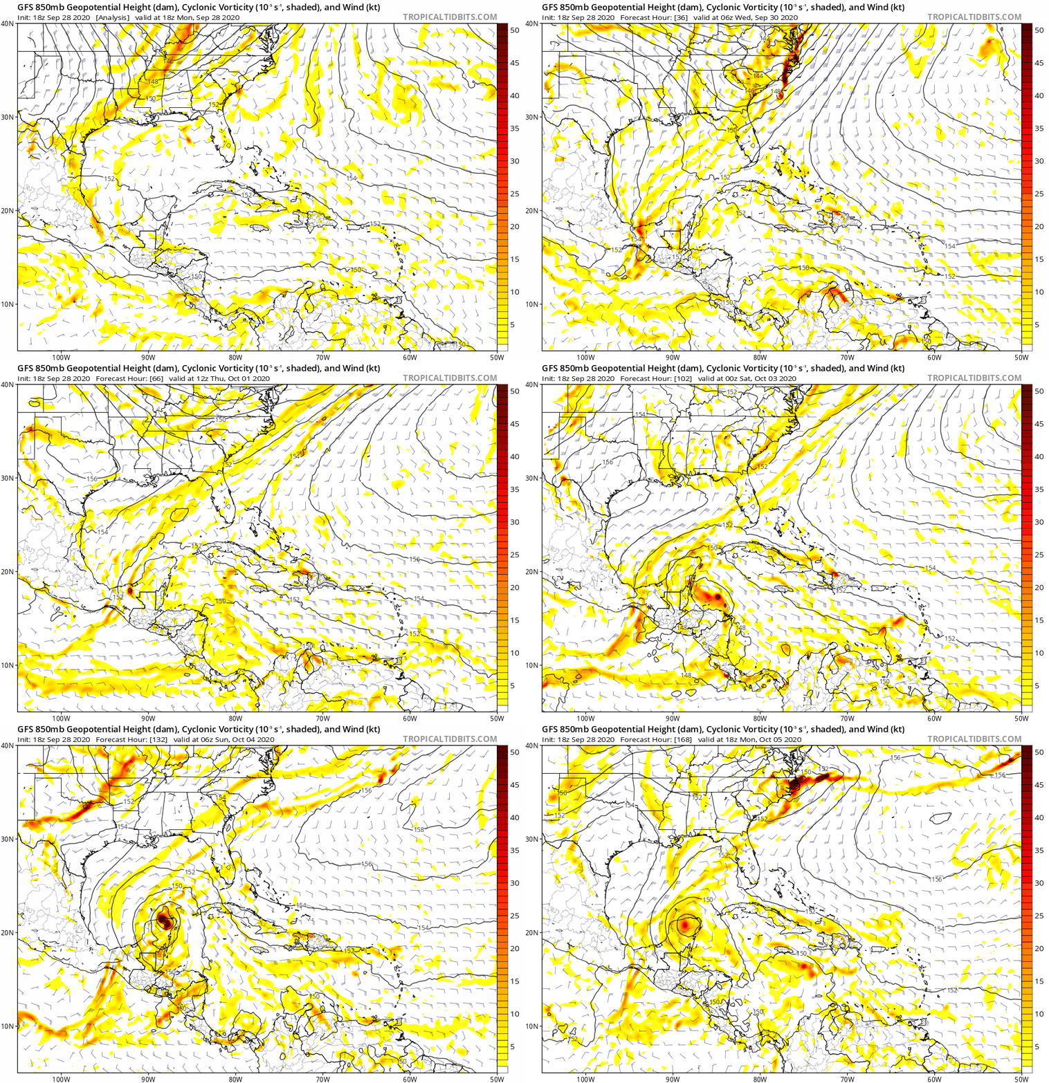
Quiet in this thread even after the GFS ran. Took a look and see why. Looks like it is actually a bit like the Euro driving this SW:

Image
Last edited by gatorcane on Mon Sep 28, 2020 6:12 pm, edited 1 time in total.
0 likes   

Loveweather12
Tropical Storm
Tropical Storm
Posts: 136
Joined: Thu Aug 20, 2020 2:37 pm

Re: Possible development in Western Caribbean

#218 Postby Loveweather12 » Mon Sep 28, 2020 6:12 pm

Nothing is set in stone. I don’t see how it goes SW when all I hear is troughs.

gatorcane wrote:Quiet in this thread even after the GFS ran. Took a look and looks like it is actually a bit like the Euro driving this SW:

https://i.postimg.cc/151BQhDT/gfs-z850-vort-watl-fh114-168.gif
3 likes   

User avatar
gatorcane
S2K Supporter
S2K Supporter
Posts: 23691
Age: 47
Joined: Sun Mar 13, 2005 3:54 pm
Location: Boca Raton, FL

Re: Possible development in Western Caribbean

#219 Postby gatorcane » Mon Sep 28, 2020 6:16 pm

Loveweather12 wrote:Nothing is set in stone. I don’t see how it goes SW when all I hear is troughs.

gatorcane wrote:Quiet in this thread even after the GFS ran. Took a look and looks like it is actually a bit like the Euro driving this SW:

https://i.postimg.cc/151BQhDT/gfs-z850-vort-watl-fh114-168.gif


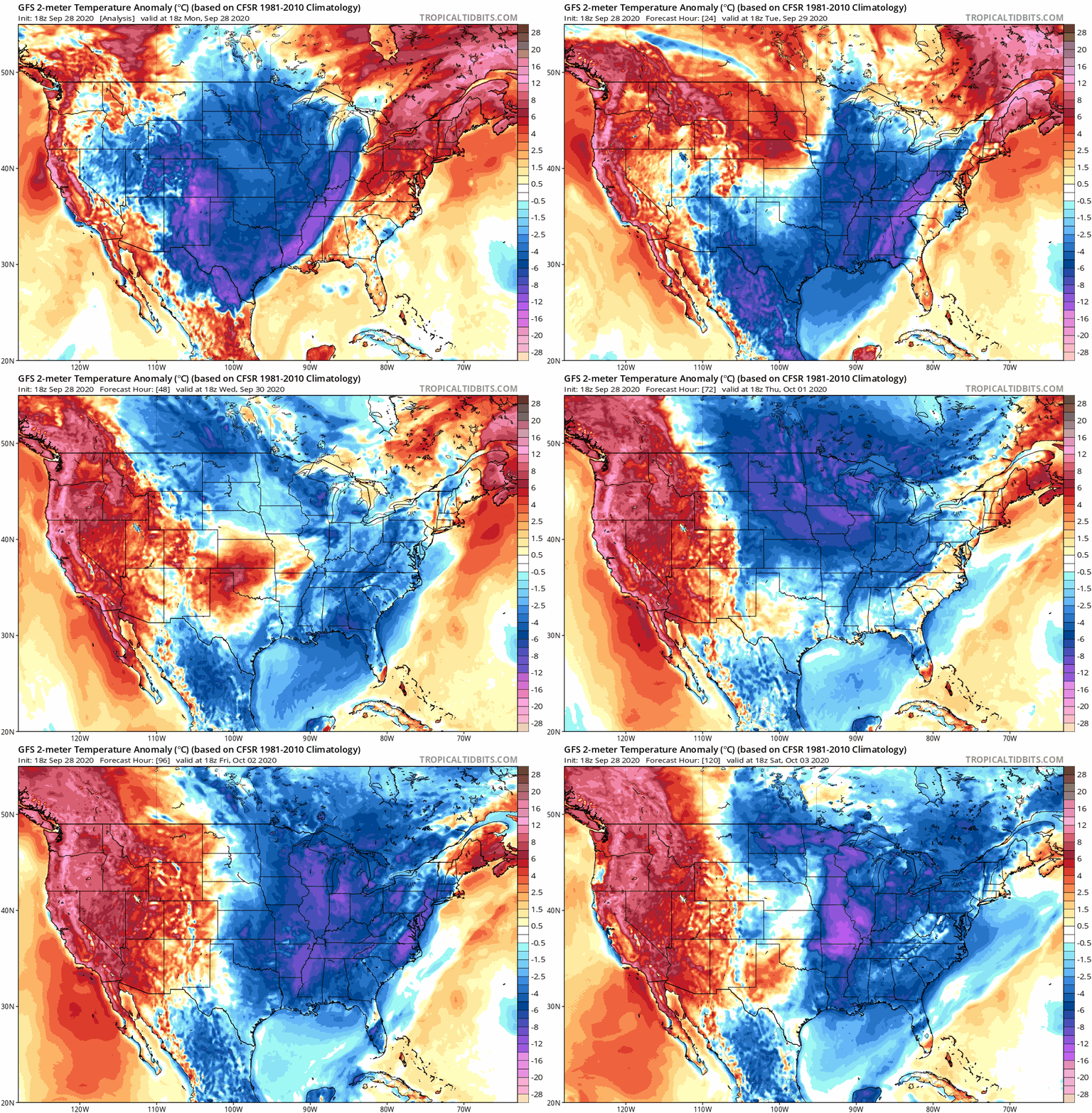
Models bring a really strong front down into the Gulf and into Florida this week reminiscent of fronts you see here in late October:

Image
0 likes   

User avatar
SFLcane
S2K Supporter
S2K Supporter
Posts: 10163
Age: 47
Joined: Sat Jun 05, 2010 1:44 pm
Location: Lake Worth Florida

Re: Possible development in Western Caribbean

#220 Postby SFLcane » Mon Sep 28, 2020 6:19 pm

Heck of a signal still coming from the gefs...if not from the first wave the second.
1 likes   


Return to “Talkin' Tropics”

Who is online

Users browsing this forum: gib, Kingarabian, lilbump3000, riapal, RomP, scotto, StormWeather, USTropics and 28 guests