Tropical Wave in the West-Central Caribbean (Is Invest 91L)

This is the general tropical discussion area. Anyone can take their shot at predicting a storms path.

Moderator: S2k Moderators
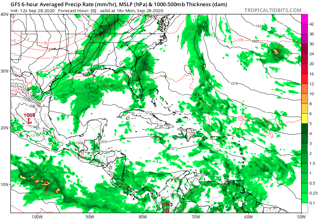
Forum rules

The posts in this forum are NOT official forecasts and should not be used as such. They are just the opinion of the poster and may or may not be backed by sound meteorological data. They are NOT endorsed by any professional institution or STORM2K. For official information, please refer to products from the National Hurricane Center and National Weather Service.

Help Support Storm2K
Message
Author
AutoPenalti
Category 5
Category 5
Posts: 4030
Age: 29
Joined: Mon Aug 17, 2015 4:16 pm
Location: Ft. Lauderdale, Florida

Re: Possible development in Western Caribbean

#161 Postby AutoPenalti » Mon Sep 28, 2020 12:31 pm

This is 12z at 6hr (18z) vs IR at 17z (CT)

Image
Image

There's a difference for sure. It's ahead of schedule.
1 likes   
The posts in this forum are NOT official forecasts and should not be used as such. They are just the opinion of the poster and may or may not be backed by sound meteorological data. They are NOT endorsed by any professional institution or STORM2K. For official information, please refer to products from the NHC and NWS.


Model Runs Cheat Sheet:
GFS (5:30 AM/PM, 11:30 AM/PM)
HWRF, GFDL, UKMET, NAVGEM (6:30-8:00 AM/PM, 12:30-2:00 AM/PM)
ECMWF (1:45 AM/PM)

TCVN
is a weighted averaged

User avatar
gatorcane
S2K Supporter
S2K Supporter
Posts: 23691
Age: 47
Joined: Sun Mar 13, 2005 3:54 pm
Location: Boca Raton, FL

Re: Possible development in Western Caribbean

#162 Postby gatorcane » Mon Sep 28, 2020 12:34 pm

Here comes the strong cold front, lows in the low 60s down into West-Central Florida. Should help cool some of those shelf waters.

Image
3 likes   

User avatar
cycloneye
Admin
Admin
Posts: 145308
Age: 68
Joined: Thu Oct 10, 2002 10:54 am
Location: San Juan, Puerto Rico

Re: Possible development in Western Caribbean: 2 PM TWO: Up to 40% in 5 days

#163 Postby cycloneye » Mon Sep 28, 2020 12:37 pm

Up to 40% in five days.

Tropical Weather Outlook
NWS National Hurricane Center Miami FL
200 PM EDT Mon Sep 28 2020

For the North Atlantic...Caribbean Sea and the Gulf of Mexico:

A broad area of low pressure is expected to form over the western
Caribbean Sea in a few days. Environmental conditions are expected
to be conducive for some gradual development thereafter, and a
tropical depression could form late this week or this weekend while
the system moves slowly west-northwestward over the northwestern
Caribbean Sea.
* Formation chance through 48 hours...low...near 0 percent.
* Formation chance through 5 days...medium...40 percent.

$$
Forecaster Reinhart/Zelinsky


Image
4 likes   
Visit the Caribbean-Central America Weather Thread where you can find at first post web cams,radars
and observations from Caribbean basin members Click Here

User avatar
SFLcane
S2K Supporter
S2K Supporter
Posts: 10163
Age: 47
Joined: Sat Jun 05, 2010 1:44 pm
Location: Lake Worth Florida

Re: Possible development in Western Caribbean

#164 Postby SFLcane » Mon Sep 28, 2020 12:42 pm

But I thought there was suppose to be shear in the Caribbean? :roll: :lol:
3 likes   

User avatar
ElectricStorm
Category 5
Category 5
Posts: 5044
Age: 24
Joined: Tue Aug 13, 2019 11:23 pm
Location: Skiatook, OK / Norman, OK

Re: Possible development in Western Caribbean

#165 Postby ElectricStorm » Mon Sep 28, 2020 12:43 pm

cycloneye wrote:Up to 40% in five days.

Tropical Weather Outlook
NWS National Hurricane Center Miami FL
200 PM EDT Mon Sep 28 2020

For the North Atlantic...Caribbean Sea and the Gulf of Mexico:

A broad area of low pressure is expected to form over the western
Caribbean Sea in a few days. Environmental conditions are expected
to be conducive for some gradual development thereafter, and a
tropical depression could form late this week or this weekend while
the system moves slowly west-northwestward over the northwestern
Caribbean Sea.
* Formation chance through 48 hours...low...near 0 percent.
* Formation chance through 5 days...medium...40 percent.

$$
Forecaster Reinhart/Zelinsky

Low expected to form in a few days... Isn't it already there south of PR?
0 likes   
B.S Meteorology, University of Oklahoma '25

Please refer to the NHC, NWS, or SPC for official information.

psyclone
S2K Supporter
S2K Supporter
Posts: 4762
Joined: Wed Aug 24, 2005 9:04 pm
Location: palm harbor fl

Re: Possible development in Western Caribbean

#166 Postby psyclone » Mon Sep 28, 2020 12:49 pm

gatorcane wrote:Here comes the strong cold front, lows in the low 60s down into West-Central Florida. Should help cool some of those shelf waters.


It's not just the cool air...more than that it is the dry air. it is tough to moderate such a dry polar airmass once it barges onto the scene. It has me bearish on the maintenance of a storm of consequence once it leaves the northwest caribbean. Obviously stuff can still happen...but this is a huge of amount of sand in the gears of tropical machinery and definitely worthy of discussion as this reels in. My gut instincts are bearish at this point and they have been all along. then again...my track record is a tad iffy..
1 likes   

xironman
S2K Supporter
S2K Supporter
Posts: 2522
Joined: Sun Jun 10, 2007 4:53 pm
Location: NoVA

Re: Possible development in Western Caribbean: 2 PM TWO: Up to 40% in 5 days

#167 Postby xironman » Mon Sep 28, 2020 1:02 pm

Tampa looks very close to climo, DPT is low Wed through Sat, but back to 70 by Sunday.

KTPA GFSX MOS GUIDANCE 9/28/2020 1200 UTC
FHR 24 36| 48 60| 72 84| 96 108|120 132|144 156|168 180|192
TUE 29| WED 30| THU 01| FRI 02| SAT 03| SUN 04| MON 05|TUE CLIMO
N/X 76 86| 67 83| 66 84| 67 84| 67 83| 70 82| 73 88| 74 70 86
TMP 77 77| 68 76| 68 78| 69 76| 68 77| 70 76| 74 80| 74
DPT 74 71| 62 57| 59 59| 60 60| 61 64| 66 70| 72 71| 71
CLD OV OV| OV CL| CL CL| PC CL| PC OV| OV OV| OV OV| OV
WND 4 14| 12 10| 6 8| 6 9| 8 10| 8 7| 7 7| 7
P12 37 78| 39 9| 4 6| 13 9| 10 21| 34 58| 31 36| 25 13 21
P24 83| 39| 6| 13| 26| 62| 45| 27
Q12 1 4| 2 0| 0 0| 0 0| 0 0| 1 5| |
Q24 4| 0| 0| 0| 0| 5| |
T12 18 56| 23 0| 0 0| 1 4| 2 11| 8 27| 11 23| 8
T24 | 56 | 0 | 2 | 4 | 15 | 29 | 27
PZP 0 0| 1 0| 0 0| 2 1| 1 1| 1 1| 2 0| 1
PSN 0 0| 0 0| 0 0| 0 0| 0 0| 0 0| 0 1| 0
PRS 0 0| 0 0| 1 1| 0 0| 0 1| 0 0| 1 1| 0
TYP R R| R R| R R| R R| R R| R R| R R| R


Eastern gulf does not appear to have a dry air problem.

Image
0 likes   

User avatar
cycloneye
Admin
Admin
Posts: 145308
Age: 68
Joined: Thu Oct 10, 2002 10:54 am
Location: San Juan, Puerto Rico

Re: Possible development in Western Caribbean

#168 Postby cycloneye » Mon Sep 28, 2020 1:16 pm

Good to see the the squadron folks are are already watching it and waiting for the call to go to work.

 https://twitter.com/53rdWRS/status/1310642944009998336


6 likes   
Visit the Caribbean-Central America Weather Thread where you can find at first post web cams,radars
and observations from Caribbean basin members Click Here

User avatar
SFLcane
S2K Supporter
S2K Supporter
Posts: 10163
Age: 47
Joined: Sat Jun 05, 2010 1:44 pm
Location: Lake Worth Florida

Re: Possible development in Western Caribbean

#169 Postby SFLcane » Mon Sep 28, 2020 1:22 pm

0 likes   

WeatherEmperor
S2K Supporter
S2K Supporter
Posts: 4806
Age: 41
Joined: Thu Sep 04, 2003 2:54 pm
Location: South Florida

Re: Possible development in Western Caribbean

#170 Postby WeatherEmperor » Mon Sep 28, 2020 1:23 pm

Euro showing stronger system

Image


Sent from my iPhone using Tapatalk
0 likes   

User avatar
toad strangler
S2K Supporter
S2K Supporter
Posts: 4543
Joined: Sun Jul 28, 2013 3:09 pm
Location: Earth
Contact:

Re: Possible development in Western Caribbean

#171 Postby toad strangler » Mon Sep 28, 2020 1:35 pm

12z Euro doing the SW shuffle too
0 likes   

User avatar
SFLcane
S2K Supporter
S2K Supporter
Posts: 10163
Age: 47
Joined: Sat Jun 05, 2010 1:44 pm
Location: Lake Worth Florida

Re: Possible development in Western Caribbean

#172 Postby SFLcane » Mon Sep 28, 2020 1:36 pm

Lol euro... Vorticity goes west moisture goes north.
0 likes   

User avatar
SFLcane
S2K Supporter
S2K Supporter
Posts: 10163
Age: 47
Joined: Sat Jun 05, 2010 1:44 pm
Location: Lake Worth Florida

Re: Possible development in Western Caribbean

#173 Postby SFLcane » Mon Sep 28, 2020 1:38 pm

GFS-P is alone and likely wrong here apparently. We shall see.
0 likes   

AutoPenalti
Category 5
Category 5
Posts: 4030
Age: 29
Joined: Mon Aug 17, 2015 4:16 pm
Location: Ft. Lauderdale, Florida

Re: Possible development in Western Caribbean

#174 Postby AutoPenalti » Mon Sep 28, 2020 1:40 pm

This may have been said already, but why is the 12z GFS-P all over the place on TT?
0 likes   
The posts in this forum are NOT official forecasts and should not be used as such. They are just the opinion of the poster and may or may not be backed by sound meteorological data. They are NOT endorsed by any professional institution or STORM2K. For official information, please refer to products from the NHC and NWS.


Model Runs Cheat Sheet:
GFS (5:30 AM/PM, 11:30 AM/PM)
HWRF, GFDL, UKMET, NAVGEM (6:30-8:00 AM/PM, 12:30-2:00 AM/PM)
ECMWF (1:45 AM/PM)

TCVN
is a weighted averaged

WeatherHoon
Tropical Storm
Tropical Storm
Posts: 131
Joined: Sat Oct 01, 2016 6:12 am

Re: Possible development in Western Caribbean

#175 Postby WeatherHoon » Mon Sep 28, 2020 1:43 pm

SFLcane wrote:GFS-P is alone and likely wrong here apparently. We shall see.


Majority of ensembles are still far east.
0 likes   

Loveweather12
Tropical Storm
Tropical Storm
Posts: 136
Joined: Thu Aug 20, 2020 2:37 pm

Re: Possible development in Western Caribbean

#176 Postby Loveweather12 » Mon Sep 28, 2020 1:57 pm

It could be right. You don’t know & I don’t know. I know the experts are giving this 40%. I’m just watching this & not being Naive & telling everyone a storm isn’t going to form considering the model performance this year.

SFLcane wrote:Lol euro... Vorticity goes west moisture goes north.
3 likes   

User avatar
SFLcane
S2K Supporter
S2K Supporter
Posts: 10163
Age: 47
Joined: Sat Jun 05, 2010 1:44 pm
Location: Lake Worth Florida

Re: Possible development in Western Caribbean

#177 Postby SFLcane » Mon Sep 28, 2020 2:05 pm

Gfs -p won’t budge...

Image
1 likes   

User avatar
SFLcane
S2K Supporter
S2K Supporter
Posts: 10163
Age: 47
Joined: Sat Jun 05, 2010 1:44 pm
Location: Lake Worth Florida

Re: Possible development in Western Caribbean

#178 Postby SFLcane » Mon Sep 28, 2020 2:07 pm

Big outlier for now.
0 likes   

User avatar
SFLcane
S2K Supporter
S2K Supporter
Posts: 10163
Age: 47
Joined: Sat Jun 05, 2010 1:44 pm
Location: Lake Worth Florida

Re: Possible development in Western Caribbean

#179 Postby SFLcane » Mon Sep 28, 2020 2:09 pm

0 likes   

User avatar
aspen
Category 5
Category 5
Posts: 8818
Joined: Sat Oct 12, 2019 7:10 pm
Location: Connecticut, USA

Re: Possible development in Western Caribbean

#180 Postby aspen » Mon Sep 28, 2020 2:16 pm

When is shear expected to become favorable for development? That wave is really vigorous, and given how everything wants to spin up this year, there’s a chance it could develop earlier than even when the GFS-Para is showing.
0 likes   
Irene '11 Sandy '12 Hermine '16 5/15/2018 Derecho Fay '20 Isaias '20 Elsa '21 Henri '21 Ida '21

I am only a meteorology enthusiast who knows a decent amount about tropical cyclones. Look to the professional mets, the NHC, or your local weather office for the best information.


Return to “Talkin' Tropics”

Who is online

Users browsing this forum: Google Adsense [Bot], ouragans, USTropics, wwizard, wxman57, Yellow Evan and 46 guests