Tropical Wave in the West-Central Caribbean (Is Invest 91L)
Moderator: S2k Moderators
Forum rules

The posts in this forum are NOT official forecasts and should not be used as such. They are just the opinion of the poster and may or may not be backed by sound meteorological data. They are NOT endorsed by any professional institution or STORM2K. For official information, please refer to products from the National Hurricane Center and National Weather Service.
-
cheezyWXguy

- Category 5

- Posts: 6282
- Joined: Mon Feb 13, 2006 12:29 am
- Location: Dallas, TX
Re: Possible development in Western Caribbean
Lol up to Brownsville and then darts east by hour 348. We may not even get a landfall in the 16 day period. Think it’s safe to throw this one out
2 likes
-
Hurricaneman

- Category 5
- Posts: 7404
- Age: 45
- Joined: Tue Aug 31, 2004 3:24 pm
- Location: central florida
Re: Possible development in Western Caribbean
cheezyWXguy wrote:Lol up to Brownsville and then darts east by hour 348. We may not even get a landfall in the 16 day period. Think it’s safe to throw this one out
If Mitch didnt happen in 1998 I'd agree with you but there is a small chance this pulls such a track but have to think its causing too much interaction with the wave behind it
0 likes
-
Hurricaneman
- Category 5
- Posts: 7404
- Age: 45
- Joined: Tue Aug 31, 2004 3:24 pm
- Location: central florida
Re: Possible development in Western Caribbean
The Euro Ensembles and Operational seems to be more in line with what is going on with this rather than the GFS and its weird track
0 likes
-
cheezyWXguy
- Category 5
- Posts: 6282
- Joined: Mon Feb 13, 2006 12:29 am
- Location: Dallas, TX
Re: Possible development in Western Caribbean
Hurricaneman wrote:cheezyWXguy wrote:Lol up to Brownsville and then darts east by hour 348. We may not even get a landfall in the 16 day period. Think it’s safe to throw this one out
If Mitch didnt happen in 1998 I'd agree with you but there is a small chance this pulls such a track but have to think its causing too much interaction with the wave behind it
The reason I think it’s bunk is because of the steering mechanism. Mitch was pushed south by a developing ridge, while this storm’s erratic movement is caused by a fujiwara interaction with the system behind it, which moves unreasonably fast through the Caribbean, in my opinion.
0 likes
-
Hurricaneman
- Category 5
- Posts: 7404
- Age: 45
- Joined: Tue Aug 31, 2004 3:24 pm
- Location: central florida
Re: Possible development in Western Caribbean
The GFS ensembles are centering on the NW Caribbean at hr 216, I'm not sure if its this system or the one behind
0 likes
-
AJC3

- Admin

- Posts: 4156
- Age: 62
- Joined: Tue Aug 31, 2004 7:04 pm
- Location: Ballston Spa, New York
- Contact:
Re: Possible development in Western Caribbean
Hurricaneman wrote:The GFS ensembles are centering on the NW Caribbean at hr 216, I'm not sure if its this system or the one behind
If you follow the H85 streamline/vort fields over the next week, you can see that the cyclogenesis is a combination of large scale mass convergence associated with two features:
1) NW-N flow pushing southward into the western Caribbean behind a strong cold front that stalls out over the area.
2) The eastern Caribbean tropical wave approaching from the east
As you mentioned, there may even be a third wave coming into the western Caribbean from the east around day 8-9, provided the system is still hanging around in the area by then. And as is usually the case, given the pattern and time frame, op-model runs are pretty 'meh' to look at compared to the ensembles.
4 likes

Re: Possible development in Western Caribbean
Looks like tomorrow a deep wave will start to interact with the persistent surface lows that normal sit offshore of Panama and Columbia
GFS spins a warm core up a couple days later.


GFS spins a warm core up a couple days later.
0 likes
Re: Possible development in Western Caribbean
Tons of LL TPW convergence from the typical land interaction with Nic / Hon and then with the very-strong front.

0 likes
Re: Possible development in Western Caribbean
The Rossby Wave associated with the strong front pulls back and falls apart once this gets in the GoM setting up a very broad Anticyclone Rossby Wave Break in the GoM for this to develop.

2 likes
Re: Possible development in Western Caribbean
ICON is right on the money with GFS for genesis, time and location.

0 likes
Re: Possible development in Western Caribbean
Appears ICON wants to take this thru the Yucatan Channel

2 likes
Re: Possible development in Western Caribbean
Navgem spins it up later and more north where ICON and GFS would have it then.
Very aggressive development into the east GoM.

Very aggressive development into the east GoM.
0 likes
Re: Possible development in Western Caribbean
GFS-Para same as Navgem.
Takes it to Tampa Bay.

Takes it to Tampa Bay.
3 likes

Re: Possible development in Western Caribbean
That's some serious trofage being modeled, depending on how potential future gamma interacts with it it could either weaken from cold, dry air and lower sst interaction, or spin it up significantly through baroclinic interactions
0 likes
-
chris_fit

- Category 5
- Posts: 3261
- Age: 43
- Joined: Wed Sep 10, 2003 11:58 pm
- Location: Tampa Bay Area, FL
Re: Possible development in Western Caribbean
06 GFS Is Really Odd. ENS though show the same story as previous runs.

ENS

ENS
0 likes
-
SFLcane

- S2K Supporter

- Posts: 10281
- Age: 48
- Joined: Sat Jun 05, 2010 1:44 pm
- Location: Lake Worth Florida
Re: Possible development in Western Caribbean
chris_fit wrote:06 GFS Is Really Odd. ENS though show the same story as previous runs.
https://i.imgur.com/N0d7lKn.gif
ENS
https://i.imgur.com/VjY5cdE.png
One would argue trof should recurve this NE eventually.
0 likes
Re: Possible development in Western Caribbean
SFLcane wrote:Can I post the Nogaps? It sure is bullish
https://i.postimg.cc/zv18Y8n6/2-DEA3951-E9-F9-444-A-A781-E1-B59890-AA33.jpg
Whats the strength?
0 likes
-
SFLcane
- S2K Supporter
- Posts: 10281
- Age: 48
- Joined: Sat Jun 05, 2010 1:44 pm
- Location: Lake Worth Florida
Re: Possible development in Western Caribbean
Fancy1001 wrote:SFLcane wrote:Can I post the Nogaps? It sure is bullish
https://i.postimg.cc/zv18Y8n6/2-DEA3951-E9-F9-444-A-A781-E1-B59890-AA33.jpg
Whats the strength?
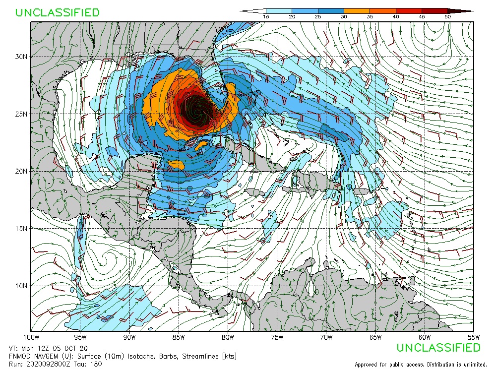
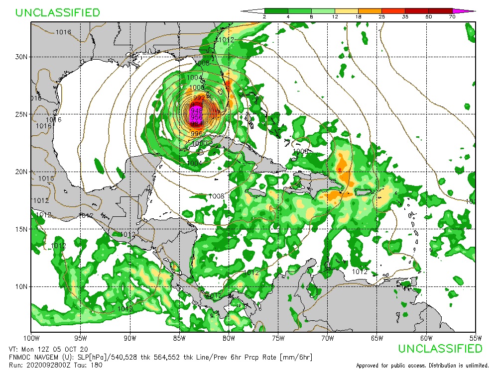
A major hurricane.
0 likes
Re: Possible development in Western Caribbean
SFLcane wrote:Fancy1001 wrote:SFLcane wrote:Can I post the Nogaps? It sure is bullish
https://i.postimg.cc/zv18Y8n6/2-DEA3951-E9-F9-444-A-A781-E1-B59890-AA33.jpg
Whats the strength?
A major hurricane.
https://i.postimg.cc/Hstc3s5r/45878426-4-A29-4128-B199-7520-FFDE95-FB.jpg
Looks like I might get to fill out another space on my 2020 bingo card within the next few weeks at this rate. CAT 4 or 5 hurricane into either tampa or miami.
0 likes
Who is online
Users browsing this forum: Google Adsense [Bot] and 242 guests