2020 Global Model Runs Discussion (Out thru day 16)

This is the general tropical discussion area. Anyone can take their shot at predicting a storms path.

Moderator: S2k Moderators

Forum rules

The posts in this forum are NOT official forecasts and should not be used as such. They are just the opinion of the poster and may or may not be backed by sound meteorological data. They are NOT endorsed by any professional institution or STORM2K. For official information, please refer to products from the National Hurricane Center and National Weather Service.

Help Support Storm2K
Message
Author
User avatar
galaxy401
Category 5
Category 5
Posts: 2419
Age: 30
Joined: Sat Aug 25, 2012 9:04 pm
Location: Casa Grande, Arizona

Re: 2020 Global Model Runs Discussion (Out thru day 16)

#2481 Postby galaxy401 » Tue Sep 22, 2020 1:39 pm

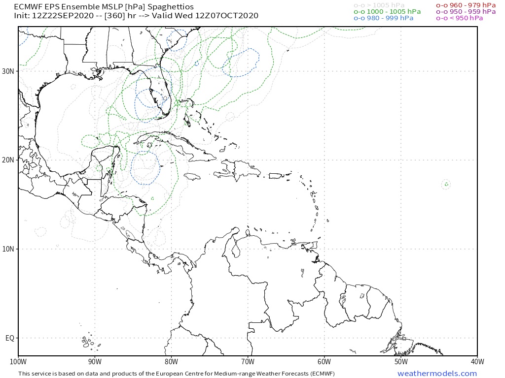
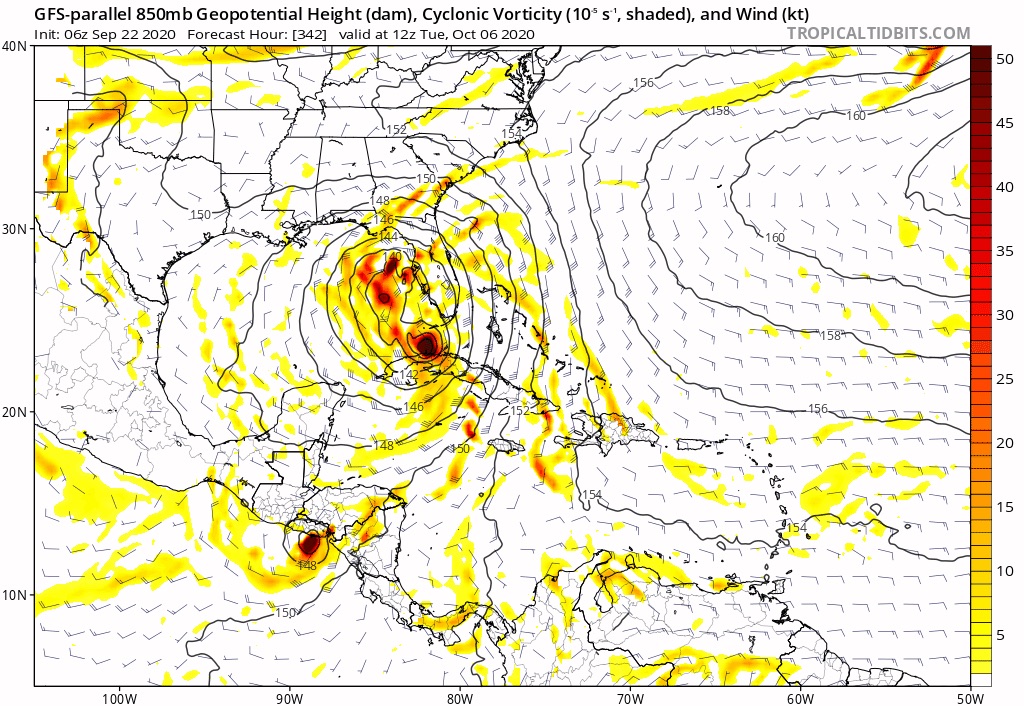
StPeteMike wrote:Besides Laura and Nana, the northern Caribbean has gone relatively untouched. No major cruisers and it’s hard to say that the area has had any brewed storms, considering Nana took her time to develop and finally did so while in the area. Anything that goes through there will bomb out pretty quick, I won’t be surprised. I could see RE similar to Wilma with a potential system there.


The Western Caribbean in general has been untouched for almost a decade now. Some storms like Michael formed in that region but mainly strengthened in the Gulf. Other storms were too weak to take advantage of the hot waters in the area and were making landfall when they did start to organize. I think Rina in 2011 was the last time we had a strong hurricane in that region.
0 likes   
Got my eyes on moving right into Hurricane Alley: Florida.

User avatar
TheProfessor
Professional-Met
Professional-Met
Posts: 3506
Age: 28
Joined: Tue Dec 03, 2013 10:56 am
Location: Wichita, Kansas

Re: 2020 Global Model Runs Discussion (Out thru day 16)

#2482 Postby TheProfessor » Tue Sep 22, 2020 1:39 pm

SFLcane wrote:
TheProfessor wrote:
SFLcane wrote:
GEFS has the same convective bias as the GFS in these situations. We can't really use the rest of the hurricane season as a comparison unfortunately. I would like to see this on the EPS


The EPS has been bad and has missed storms this year, waiting for that might mean waiting until the systems forms in the Caribbean. If the GEFS-para and GEFS were on their own, that would be one thing, but they also have the GEPS on board(which is likely a bit too aggressive right now.).


Burned to many times but this ridiculous model bias on the gfs. Meh... :roll:

https://twitter.com/mjventrice/status/1308457623897993217?


Look at my reply to his tweet. :wink:
4 likes   
An alumnus of The Ohio State University.

Your local National Weather Service office is your best source for weather information.

User avatar
SFLcane
S2K Supporter
S2K Supporter
Posts: 10163
Age: 47
Joined: Sat Jun 05, 2010 1:44 pm
Location: Lake Worth Florida

Re: 2020 Global Model Runs Discussion (Out thru day 16)

#2483 Postby SFLcane » Tue Sep 22, 2020 1:44 pm

TheProfessor wrote:
SFLcane wrote:
TheProfessor wrote:
The EPS has been bad and has missed storms this year, waiting for that might mean waiting until the systems forms in the Caribbean. If the GEFS-para and GEFS were on their own, that would be one thing, but they also have the GEPS on board(which is likely a bit too aggressive right now.).


Burned to many times but this ridiculous model bias on the gfs. Meh... :roll:

https://twitter.com/mjventrice/status/1308457623897993217?


Look at my reply to his tweet. :wink:


I see... well we shall see.
0 likes   

User avatar
TheProfessor
Professional-Met
Professional-Met
Posts: 3506
Age: 28
Joined: Tue Dec 03, 2013 10:56 am
Location: Wichita, Kansas

Re: 2020 Global Model Runs Discussion (Out thru day 16)

#2484 Postby TheProfessor » Tue Sep 22, 2020 1:48 pm

SFLcane wrote:
TheProfessor wrote:
SFLcane wrote:
Burned to many times but this ridiculous model bias on the gfs. Meh... :roll:

https://twitter.com/mjventrice/status/1308457623897993217?


Look at my reply to his tweet. :wink:


I see... well we shall see.


It will likely be obvious in the next 5-7 days instead of 10-14 days. Since the source of this storm is from a tropical wave and not a random phantom, if that wave doesn't survive the MDR then we should see the ensembles show less and less support.
2 likes   
An alumnus of The Ohio State University.

Your local National Weather Service office is your best source for weather information.

User avatar
SFLcane
S2K Supporter
S2K Supporter
Posts: 10163
Age: 47
Joined: Sat Jun 05, 2010 1:44 pm
Location: Lake Worth Florida

Re: 2020 Global Model Runs Discussion (Out thru day 16)

#2485 Postby SFLcane » Tue Sep 22, 2020 2:12 pm

12z GFS-p ensembles...

Image
0 likes   

User avatar
SouthFLTropics
Category 5
Category 5
Posts: 4236
Age: 50
Joined: Thu Aug 14, 2003 8:04 am
Location: Port St. Lucie, Florida

Re: 2020 Global Model Runs Discussion (Out thru day 16)

#2486 Postby SouthFLTropics » Tue Sep 22, 2020 2:52 pm

If you watch this loop of the 12z Euro Ensembles, late in the period when you get into the 200+ hour range you will notice that it starts to light up in the South Central Caribbean. Early indicators of what's to come on future runs??? Maybe it is, Maybe it isn't. Stay tuned...

Image
0 likes   
Fourth Generation Florida Native

Personal Storm History: David 79, Andrew 92, Erin 95, Floyd 99, Irene 99, Frances 04, Jeanne 04, Wilma 05, Matthew 16, Irma 17, Ian 22, Nicole 22, Milton 24

User avatar
SouthFLTropics
Category 5
Category 5
Posts: 4236
Age: 50
Joined: Thu Aug 14, 2003 8:04 am
Location: Port St. Lucie, Florida

Re: 2020 Global Model Runs Discussion (Out thru day 16)

#2487 Postby SouthFLTropics » Tue Sep 22, 2020 2:55 pm

Meanwhile, while we post the 12z runs, I'm over here tapping my fingers waiting for the 06z run of the GFS-Para to complete on TT... I want to see if shows the same hijinks that the 00z run did last night.
2 likes   
Fourth Generation Florida Native

Personal Storm History: David 79, Andrew 92, Erin 95, Floyd 99, Irene 99, Frances 04, Jeanne 04, Wilma 05, Matthew 16, Irma 17, Ian 22, Nicole 22, Milton 24

User avatar
cheezyWXguy
Category 5
Category 5
Posts: 6108
Joined: Mon Feb 13, 2006 12:29 am
Location: Dallas, TX

Re: 2020 Global Model Runs Discussion (Out thru day 16)

#2488 Postby cheezyWXguy » Tue Sep 22, 2020 3:28 pm

TheProfessor wrote:
SFLcane wrote:
TheProfessor wrote:
Look at my reply to his tweet. :wink:


I see... well we shall see.


It will likely be obvious in the next 5-7 days instead of 10-14 days. Since the source of this storm is from a tropical wave and not a random phantom, if that wave doesn't survive the MDR then we should see the ensembles show less and less support.

I’m not even sure where ventrice is getting this. The storm is clearly still there on the gfs and forms at the same time. The only reason it doesn’t get very strong is because of land interaction. I don’t see a decrease in signal on the gfs, gefs, para, or para ensembles, even though the tracks are all over the place
2 likes   

WxEp
Tropical Depression
Tropical Depression
Posts: 71
Joined: Sat Sep 14, 2019 2:34 pm

Re: 2020 Global Model Runs Discussion (Out thru day 16)

#2489 Postby WxEp » Tue Sep 22, 2020 3:30 pm

12z EPS starting to come onboard. This system does not appear to be a phantom to me, especially because it is coming from an existing wave and not a GFS phantom CAG like we sometimes see.

Image
2 likes   
The posts in this forum are NOT official forecast and should not be used as such. They are just the opinion of the poster and may or may not be backed by sound meteorological data. They are NOT endorsed by any professional institution or STORM2K. For official information, refer to products from the National Hurricane Center and National Weather Service.

User avatar
SFLcane
S2K Supporter
S2K Supporter
Posts: 10163
Age: 47
Joined: Sat Jun 05, 2010 1:44 pm
Location: Lake Worth Florida

Re: 2020 Global Model Runs Discussion (Out thru day 16)

#2490 Postby SFLcane » Tue Sep 22, 2020 3:41 pm

WxEp wrote:12z EPS starting to come onboard. This system does not appear to be a phantom to me, especially because it is coming from an existing wave and not a GFS phantom CAG like we sometimes see.

https://i.imgur.com/EUTe9QP.png


Ok now this is something.
0 likes   

AutoPenalti
Category 5
Category 5
Posts: 4030
Age: 29
Joined: Mon Aug 17, 2015 4:16 pm
Location: Ft. Lauderdale, Florida

Re: 2020 Global Model Runs Discussion (Out thru day 16)

#2491 Postby AutoPenalti » Tue Sep 22, 2020 3:44 pm

SFLcane wrote:
WxEp wrote:12z EPS starting to come onboard. This system does not appear to be a phantom to me, especially because it is coming from an existing wave and not a GFS phantom CAG like we sometimes see.

https://i.imgur.com/EUTe9QP.png


Ok now this is something.

Time to @ Mikey on his Twitch chat.
0 likes   
The posts in this forum are NOT official forecasts and should not be used as such. They are just the opinion of the poster and may or may not be backed by sound meteorological data. They are NOT endorsed by any professional institution or STORM2K. For official information, please refer to products from the NHC and NWS.


Model Runs Cheat Sheet:
GFS (5:30 AM/PM, 11:30 AM/PM)
HWRF, GFDL, UKMET, NAVGEM (6:30-8:00 AM/PM, 12:30-2:00 AM/PM)
ECMWF (1:45 AM/PM)

TCVN
is a weighted averaged

User avatar
aspen
Category 5
Category 5
Posts: 8819
Joined: Sat Oct 12, 2019 7:10 pm
Location: Connecticut, USA

Re: 2020 Global Model Runs Discussion (Out thru day 16)

#2492 Postby aspen » Tue Sep 22, 2020 3:48 pm

WxEp wrote:12z EPS starting to come onboard. This system does not appear to be a phantom to me, especially because it is coming from an existing wave and not a GFS phantom CAG like we sometimes see.

https://i.imgur.com/EUTe9QP.png

What’s even more interesting is the strong signal for a strong TS or a hurricane in the MDR. Maybe Hurricanes Gamma and Delta are coming for early October?
0 likes   
Irene '11 Sandy '12 Hermine '16 5/15/2018 Derecho Fay '20 Isaias '20 Elsa '21 Henri '21 Ida '21

I am only a meteorology enthusiast who knows a decent amount about tropical cyclones. Look to the professional mets, the NHC, or your local weather office for the best information.

User avatar
SFLcane
S2K Supporter
S2K Supporter
Posts: 10163
Age: 47
Joined: Sat Jun 05, 2010 1:44 pm
Location: Lake Worth Florida

Re: 2020 Global Model Runs Discussion (Out thru day 16)

#2493 Postby SFLcane » Tue Sep 22, 2020 3:49 pm

Image
0 likes   

User avatar
SFLcane
S2K Supporter
S2K Supporter
Posts: 10163
Age: 47
Joined: Sat Jun 05, 2010 1:44 pm
Location: Lake Worth Florida

Re: 2020 Global Model Runs Discussion (Out thru day 16)

#2494 Postby SFLcane » Tue Sep 22, 2020 4:12 pm

SouthFLTropics wrote:Meanwhile, while we post the 12z runs, I'm over here tapping my fingers waiting for the 06z run of the GFS-Para to complete on TT... I want to see if shows the same hijinks that the 00z run did last night.


Image
0 likes   

User avatar
SFLcane
S2K Supporter
S2K Supporter
Posts: 10163
Age: 47
Joined: Sat Jun 05, 2010 1:44 pm
Location: Lake Worth Florida

Re: 2020 Global Model Runs Discussion (Out thru day 16)

#2495 Postby SFLcane » Tue Sep 22, 2020 4:14 pm

Caribbean is now highlighted for potential TC development.

Image
0 likes   

User avatar
SFLcane
S2K Supporter
S2K Supporter
Posts: 10163
Age: 47
Joined: Sat Jun 05, 2010 1:44 pm
Location: Lake Worth Florida

Re: 2020 Global Model Runs Discussion (Out thru day 16)

#2496 Postby SFLcane » Tue Sep 22, 2020 4:17 pm

Interesting...

Image
0 likes   

User avatar
toad strangler
S2K Supporter
S2K Supporter
Posts: 4543
Joined: Sun Jul 28, 2013 3:09 pm
Location: Earth
Contact:

Re: 2020 Global Model Runs Discussion (Out thru day 16)

#2497 Postby toad strangler » Tue Sep 22, 2020 4:18 pm

SFLcane wrote:Caribbean is now highlighted for potential TC development.

https://i.postimg.cc/KcDrbtxW/6-A425183-3367-450-E-84-E5-1038-EA911181.jpg


OK that is intriguing.
0 likes   

User avatar
cheezyWXguy
Category 5
Category 5
Posts: 6108
Joined: Mon Feb 13, 2006 12:29 am
Location: Dallas, TX

Re: 2020 Global Model Runs Discussion (Out thru day 16)

#2498 Postby cheezyWXguy » Tue Sep 22, 2020 4:21 pm

SFLcane wrote:
SouthFLTropics wrote:Meanwhile, while we post the 12z runs, I'm over here tapping my fingers waiting for the 06z run of the GFS-Para to complete on TT... I want to see if shows the same hijinks that the 00z run did last night.


https://i.postimg.cc/W4YCXxfM/A45-C8-AD4-9-B4-B-4-EBF-BC36-EDACF955-A410.jpg

Ha that’s a pretty bizarre looking evolution of that system. Like a TS and cat1 joined at the hip
0 likes   

User avatar
SouthFLTropics
Category 5
Category 5
Posts: 4236
Age: 50
Joined: Thu Aug 14, 2003 8:04 am
Location: Port St. Lucie, Florida

Re: 2020 Global Model Runs Discussion (Out thru day 16)

#2499 Postby SouthFLTropics » Tue Sep 22, 2020 4:48 pm

cheezyWXguy wrote:
SFLcane wrote:
SouthFLTropics wrote:Meanwhile, while we post the 12z runs, I'm over here tapping my fingers waiting for the 06z run of the GFS-Para to complete on TT... I want to see if shows the same hijinks that the 00z run did last night.


https://i.postimg.cc/W4YCXxfM/A45-C8-AD4-9-B4-B-4-EBF-BC36-EDACF955-A410.jpg

Ha that’s a pretty bizarre looking evolution of that system. Like a TS and cat1 joined at the hip


Probably a sloppy and sheared TS or low end Cat 1 getting pulled quickly out of the Caribbean and riding the front North Northeast. Large coverage area but quick moving. You can see it gets snatched out of the Caribbean and is up to near Georgia within 36 hours. Irene from 1999 may be a good analog.
2 likes   
Fourth Generation Florida Native

Personal Storm History: David 79, Andrew 92, Erin 95, Floyd 99, Irene 99, Frances 04, Jeanne 04, Wilma 05, Matthew 16, Irma 17, Ian 22, Nicole 22, Milton 24

User avatar
MetroMike
Category 4
Category 4
Posts: 952
Joined: Sun Aug 29, 2004 8:13 pm
Location: Tampa Bay
Contact:

Re: 2020 Global Model Runs Discussion (Out thru day 16)

#2500 Postby MetroMike » Tue Sep 22, 2020 5:03 pm

cheezyWXguy wrote:
TheProfessor wrote:
SFLcane wrote:
I see... well we shall see.


It will likely be obvious in the next 5-7 days instead of 10-14 days. Since the source of this storm is from a tropical wave and not a random phantom, if that wave doesn't survive the MDR then we should see the ensembles show less and less support.

I’m not even sure where ventrice is getting this. The storm is clearly still there on the gfs and forms at the same time. The only reason it doesn’t get very strong is because of land interaction. I don’t see a decrease in signal on the gfs, gefs, para, or para ensembles, even though the tracks are all over the place


May be a case of Ventrice wanting to see something develop but if it does not at least he was right.
2 likes   


Return to “Talkin' Tropics”

Who is online

Users browsing this forum: Cpv17, DustStorm92, ElectricStorm, Google Adsense [Bot], StPeteMike and 69 guests