Disturbance over The Bahamas (Is Invest 96L)

This is the general tropical discussion area. Anyone can take their shot at predicting a storms path.

Moderator: S2k Moderators

Forum rules

The posts in this forum are NOT official forecasts and should not be used as such. They are just the opinion of the poster and may or may not be backed by sound meteorological data. They are NOT endorsed by any professional institution or STORM2K. For official information, please refer to products from the National Hurricane Center and National Weather Service.

Help Support Storm2K
Message
Author
User avatar
NDG
S2K Supporter
S2K Supporter
Posts: 15446
Joined: Sun Jul 09, 2006 10:14 pm
Location: Orlando, FL

Re: Disturbance east of Bahamas

#61 Postby NDG » Thu Sep 10, 2020 9:20 am

us89 wrote:
aspen wrote:I don't like how models are showing this stick around for a while in the Gulf. Definitely raises a few eyebrows, since SSTs have just about completely recovered since Laura and we've seen RI twice in the Gulf this year, one of which (Hanna) that was horribly predicted by the globals.


Even if SSTs have fully recovered, the sub-surface waters largely have not. Note especially the large cool wake north of the Yucatan Channel:

https://i.imgur.com/GLgFBNs.gif

If this were to intensify in the GOM, it would upwell substantially cooler water relatively quickly.


Deep warm waters are only good for MHs that stall over the same area. Shallow warm SSTs like in the middle of the EPAC are more than enough to support a moving MH or for a MH to develop on top them.

Image
Image
1 likes   

User avatar
boca
Category 5
Category 5
Posts: 6367
Age: 60
Joined: Mon Dec 15, 2003 8:49 am
Location: Boca Raton,FL

Re: Disturbance east of Bahamas

#62 Postby boca » Thu Sep 10, 2020 9:37 am

This could develop in the Bahamas before reaching the coast of Florida it has the look.
1 likes   

TheStormExpert

Re: Disturbance east of Bahamas

#63 Postby TheStormExpert » Thu Sep 10, 2020 9:54 am

aspen wrote:
TheStormExpert wrote:You do have to wonder if this could snag the name Sally before the wave that just emerged Africa?

That would mean major hurricane Teddy would be on its way. Imagine a monstrous long tracking Cat 4/5 hurricane named Teddy. You can’t get much more of a juxtaposition than that.

That’s fine with me! I like the name Teddy better than Sally anyways. :cheesy:
0 likes   

User avatar
northjaxpro
S2K Supporter
S2K Supporter
Posts: 8900
Joined: Mon Sep 27, 2010 11:21 am
Location: Jacksonville, FL

Re: Disturbance east of Bahamas

#64 Postby northjaxpro » Thu Sep 10, 2020 10:02 am

I am wondering when NHC will tag this area an invest. I have to believe with how this disturbance is coming together, this will be tagged fairly soon.
0 likes   
NEVER, EVER SAY NEVER in the tropics and weather in general, and most importantly, with life itself!!

________________________________________________________________________________________

Fay 2008 Beryl 2012 Debby 2012 Colin 2016 Hermine 2016 Julia 2016 Matthew 2016 Irma 2017 Dorian 2019

sma10
Category 5
Category 5
Posts: 1710
Joined: Tue Aug 02, 2005 1:13 pm

Re: Disturbance east of Bahamas

#65 Postby sma10 » Thu Sep 10, 2020 10:26 am

northjaxpro wrote:I am wondering when NHC will tag this area an invest. I have to believe with how this disturbance is coming together, this will be tagged fairly soon.


Especially considering they tend to pull the trigger on these kind of things quicker when they are closer to land
0 likes   

LarryWx
S2K Supporter
S2K Supporter
Posts: 6305
Joined: Sun Sep 07, 2003 2:04 pm
Location: GA

Re: Disturbance east of Bahamas

#66 Postby LarryWx » Thu Sep 10, 2020 10:37 am

Is there a closed surface circ with this? If there is, I don’t see it on the visible sat loop. At least for 94L, there was a persistent low level swirl for a good number of days that Aric first pointed out.
If there is a definitive LLC, would someone please say exactly where it is? Thank you.
1 likes   
Personal Forecast Disclaimer:
The posts in this forum are NOT official forecasts and should not be used as such. They are just the opinion of the poster and may or may not be backed by sound meteorological data. They are NOT endorsed by any professional institution or storm2k.org. For official information, please refer to the NHC and NWS products.

User avatar
gfsperpendicular
Category 1
Category 1
Posts: 383
Age: 21
Joined: Mon Jun 19, 2017 3:04 pm
Location: Northern Virginia

Re: Disturbance east of Bahamas

#67 Postby gfsperpendicular » Thu Sep 10, 2020 10:46 am

LarryWx wrote:Is there a closed surface circ with this? If there is, I don’t see it on the visible sat loop. At least for 94L, there was a persistent low level swirl for a good number of days that Aric first pointed out.
If there is a definitive LLC, would someone please say exactly where it is? Thank you.

The vorticity remains very broad with this system. This image is 6 hours old, but it does show how loose the system is.
Image
0 likes   
I'm not sleeping, I'm waiting for the 0900 UTC advisory!

#1 CMC stan

jlauderdal
S2K Supporter
S2K Supporter
Posts: 7182
Joined: Wed May 19, 2004 5:46 am
Location: NE Fort Lauderdale
Contact:

Re: RE: Re: Mid Level Disturbance to the S of 94L

#68 Postby jlauderdal » Thu Sep 10, 2020 10:55 am

boca wrote:
northjaxpro wrote:
boca wrote:Good move jlauderdale but I don’t think this system will develop until after it crosses Florida but it’s good to be cautious since it has that circular look.


There is always a possibility that this system , given decent conditions, which this has right now, could spin up quickly as it drifts toward the Gulf Stream by Friday. There are very warm ssts over the Florida Straits and off the Southeast Florida Coast.

I too think it will be better positioned once in the Eastern Gulf, but hey, this is 2020. Anything goes this season seemingly.


I agree on a side note Denver it snowed today and was 101 two days ago that’s bipolar weather.


I was in colorado last week, left denver sunday it was 97 and smoke in the air...snowed two days later
0 likes   

User avatar
HurricaneEnzo
Category 2
Category 2
Posts: 739
Joined: Wed Mar 14, 2018 12:18 pm
Location: Newport, NC (Hurricane Alley)

Re: Disturbance east of Bahamas

#69 Postby HurricaneEnzo » Thu Sep 10, 2020 11:08 am

Just me personally not really seeing a whole lot here. A lot of unorganized convection that hasn't really shown any signs of getting any better organized the last couple of days. Minimal vorticity in the area. Just don't really see a lot happening with this in the short term. Maybe once it gets in the Gulf will have to see how it plays out, but I don't have much confidence in this area doing much of anything other than bringing some rain to FL.
1 likes   
Bertha 96' - Fran 96' - Bonnie 98' - Dennis 99' - Floyd 99' - Isabel 03' - Alex 04' - Ophelia 05' - Irene 11' - Arthur 14' - Matthew 16' - Florence 18' - Dorian 19' - Isaias 20' (countless other tropical storms and Hurricane swipes)

I am not a Professional Met just an enthusiast. Get your weather forecasts from the Pros!

User avatar
SFLcane
S2K Supporter
S2K Supporter
Posts: 10163
Age: 47
Joined: Sat Jun 05, 2010 1:44 pm
Location: Lake Worth Florida

Re: Disturbance east of Bahamas

#70 Postby SFLcane » Thu Sep 10, 2020 12:03 pm

Convection increasing a bit.

Image
1 likes   

User avatar
NDG
S2K Supporter
S2K Supporter
Posts: 15446
Joined: Sun Jul 09, 2006 10:14 pm
Location: Orlando, FL

Re: Disturbance east of Bahamas

#71 Postby NDG » Thu Sep 10, 2020 12:12 pm

LarryWx wrote:Is there a closed surface circ with this? If there is, I don’t see it on the visible sat loop. At least for 94L, there was a persistent low level swirl for a good number of days that Aric first pointed out.
If there is a definitive LLC, would someone please say exactly where it is? Thank you.


As you may know, Invests are declared on a disturbance/TW without having a surface circulation all the time. They look for at least tight vorticity to start an approximate fix on the Invest. In this case the vorticity is still greater in the mid levels so I am sure they are waiting for a more pronounced vorticity closer to the surface to declare it an Invest, latest GFS shows it getting one by late tomorrow, but if models continue to trend towards development the mid level vorticity might be good enough.
2 likes   

blacktopninja
Tropical Low
Tropical Low
Posts: 11
Joined: Thu Sep 10, 2020 9:22 am

Re: Disturbance east of Bahamas

#72 Postby blacktopninja » Thu Sep 10, 2020 12:18 pm

This could organize into a Tropical Storm over the next 2-3 days before trekking past Florida. It's pretty juiced up, and we might be in store for a light show if this thing tries to develop during the overnight hours as it crosses the East Coast of S. FL.
0 likes   

Aric Dunn
Category 5
Category 5
Posts: 21238
Age: 42
Joined: Sun Sep 19, 2004 9:58 pm
Location: Ready for the Chase.
Contact:

Re: Disturbance east of Bahamas

#73 Postby Aric Dunn » Thu Sep 10, 2020 12:20 pm

The last several hours there is definitely some borad curvature to the low level clouds and surface obs in the bahamas have swithed to the NE... a sign the surface trough is sharpening.

if it can develop a decent low level broad circ before the gulf.. then development chances go way up.

https://weather.cod.edu/satrad/?parms=s ... =undefined
6 likes   
Note: If I make a post that is brief. Please refer back to previous posts for the analysis or reasoning. I do not re-write/qoute what my initial post said each time.
If there is nothing before... then just ask :)

Space & Atmospheric Physicist, Embry-Riddle Aeronautical University,
I believe the sky is falling...

User avatar
northjaxpro
S2K Supporter
S2K Supporter
Posts: 8900
Joined: Mon Sep 27, 2010 11:21 am
Location: Jacksonville, FL

Re: Disturbance east of Bahamas

#74 Postby northjaxpro » Thu Sep 10, 2020 12:25 pm

NDG wrote:
LarryWx wrote:Is there a closed surface circ with this? If there is, I don’t see it on the visible sat loop. At least for 94L, there was a persistent low level swirl for a good number of days that Aric first pointed out.
If there is a definitive LLC, would someone please say exactly where it is? Thank you.


As you may know, Invests are declared on a disturbance/TW without having a surface circulation all the time. They look for at least tight vorticity to start an approximate fix on the Invest. In this case the vorticity is still greater in the mid levels so I am sure they are waiting for a more pronounced vorticity closer to the surface to declare it an Invest, latest GFS shows it getting one by late tomorrow, but if models continue to trend towards development the mid level vorticity might be good enough.


Yes, good analysis NDG. The overall vorticity is broad, but convection is gradually building. The mid-level vort is now moving into the Central Bahamas. The 12Z GFS does close off a surface relection (1010 mb) by Saturday mornng.
I think they will tag this area either lste tonight or into tomorrow morning.
Last edited by northjaxpro on Thu Sep 10, 2020 12:25 pm, edited 1 time in total.
0 likes   
NEVER, EVER SAY NEVER in the tropics and weather in general, and most importantly, with life itself!!

________________________________________________________________________________________

Fay 2008 Beryl 2012 Debby 2012 Colin 2016 Hermine 2016 Julia 2016 Matthew 2016 Irma 2017 Dorian 2019

User avatar
NDG
S2K Supporter
S2K Supporter
Posts: 15446
Joined: Sun Jul 09, 2006 10:14 pm
Location: Orlando, FL

Re: Disturbance east of Bahamas

#75 Postby NDG » Thu Sep 10, 2020 12:25 pm

Aric Dunn wrote:The last several hours there is definitely some borad curvature to the low level clouds and surface obs in the bahamas have swithed to the NE... a sign the surface trough is sharpening.

if it can develop a decent low level broad circ before the gulf.. then development chances go way up.

https://weather.cod.edu/satrad/?parms=s ... =undefined


Is definitely starting to get that look of an organizing tropical disturbance little by little.
0 likes   

User avatar
gatorcane
S2K Supporter
S2K Supporter
Posts: 23691
Age: 47
Joined: Sun Mar 13, 2005 3:54 pm
Location: Boca Raton, FL

Re: Disturbance east of Bahamas

#76 Postby gatorcane » Thu Sep 10, 2020 12:28 pm

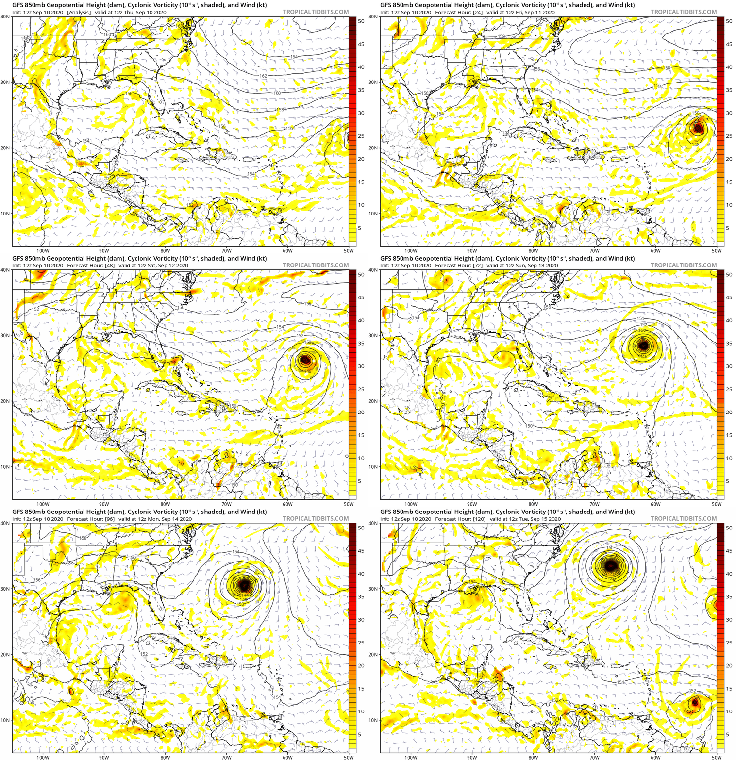
Saved GFS loop showing surface low developing and tracking over Florida and into the Gulf:

Image
2 likes   

User avatar
cycloneye
Admin
Admin
Posts: 145303
Age: 68
Joined: Thu Oct 10, 2002 10:54 am
Location: San Juan, Puerto Rico

Re: Disturbance east of Bahamas

#77 Postby cycloneye » Thu Sep 10, 2020 12:47 pm

A large area of disorganized showers and thunderstorms centered a
couple of hundred miles east of the Central Bahamas is associated
with a surface trough of low pressure. This system is forecast to
move westward, crossing the Bahamas and Florida on Friday and moving
into the eastern Gulf of Mexico over the weekend. Upper-level
winds are expected to become conducive for development, and a
tropical depression could form while this system moves slowly
west-northwestward over the eastern Gulf of Mexico early next week.
* Formation chance through 48 hours...low...10 percent.
* Formation chance through 5 days...medium...40 percent.
1 likes   
Visit the Caribbean-Central America Weather Thread where you can find at first post web cams,radars
and observations from Caribbean basin members Click Here

User avatar
ElectricStorm
Category 5
Category 5
Posts: 5044
Age: 24
Joined: Tue Aug 13, 2019 11:23 pm
Location: Skiatook, OK / Norman, OK

Re: Disturbance east of Bahamas

#78 Postby ElectricStorm » Thu Sep 10, 2020 12:51 pm

cycloneye wrote:
A large area of disorganized showers and thunderstorms centered a
couple of hundred miles east of the Central Bahamas is associated
with a surface trough of low pressure. This system is forecast to
move westward, crossing the Bahamas and Florida on Friday and moving
into the eastern Gulf of Mexico over the weekend. Upper-level
winds are expected to become conducive for development, and a
tropical depression could form while this system moves slowly
west-northwestward over the eastern Gulf of Mexico early next week.
* Formation chance through 48 hours...low...10 percent.
* Formation chance through 5 days...medium...40 percent.

Up to medium... Moving slow into the gulf. Not good
1 likes   
B.S Meteorology, University of Oklahoma '25

Please refer to the NHC, NWS, or SPC for official information.

User avatar
Nimbus
Category 5
Category 5
Posts: 5300
Joined: Mon Jul 19, 2004 10:54 am

Re: Disturbance east of Bahamas

#79 Postby Nimbus » Thu Sep 10, 2020 1:02 pm

I'm late to the party on this one, wanted to see some buoy reports to see how strong this wave is.
Probably will have a circulation by the time it crosses Florida from the looks of the upper level structure.
1 likes   

User avatar
Blinhart
Category 5
Category 5
Posts: 2079
Age: 48
Joined: Thu Sep 08, 2011 3:13 pm
Location: Crowley, La.

Re: Disturbance east of Bahamas

#80 Postby Blinhart » Thu Sep 10, 2020 1:07 pm

From I understand though they don't expect this to actually form until it gets into the GoM, what do other models show?
0 likes   
Personal Forecast Disclaimer:
The posts in this forum are NOT official forecast and should not be used as such. They are just the opinion of the poster and may or may not be backed by sound meteorological data. They are NOT endorsed by any professional institution or storm2k.org. For official information, please refer to the NHC and NWS products.


Return to “Talkin' Tropics”

Who is online

Users browsing this forum: Kingarabian, USTropics and 44 guests