
While an OTS solution is still most likely due to the latitude it will gain by the time it reaches 60W, we'll have to keep an eye on the 500 mb pattern in the SW Atlantic. If the storm is weaker and follows a slightly more southern track near the VI or PR AND mid level ridging builds in about a week per latest Euro, then this storm could threaten Bahamas or east US coast.
https://www.tropicaltidbits.com/analysis/models/?model=ecmwf®ion=watl&pkg=z500aNorm&runtime=2020090700&fh=168
ATL: PAULETTE - Models
Moderator: S2k Moderators
Re: ATL: SEVENTEEN - Models
1 likes
-
plasticup
Re: ATL: SEVENTEEN - Models
ronjon wrote:While an OTS solution is still most likely due to the latitude it will gain by the time it reaches 60W, we'll have to keep an eye on the 500 mb pattern in the SW Atlantic. If the storm is weaker and follows a slightly more southern track near the VI or PR AND mid level ridging builds in about a week per latest Euro, then this storm could threaten Bahamas or east US coast.
https://www.tropicaltidbits.com/analysis/models/?model=ecmwf®ion=watl&pkg=z500aNorm&runtime=2020090700&fh=168
Just to be clear, this "OTS solution" literally shows a landfall on Bermuda.
7 likes

Re: ATL: PAULETTE - Models
Both the 12z GFS and 12z CMC have Paulette remain on the weaker side until 6-7 days out as it nears Bermuda and finds more favorable conditions to intensify. The GFS has a Category 3 hurricane in 9-10 days, which is too far out to take literally, but it suggests Paulette could have a better opportunity to strengthen down the road.
2 likes
Irene '11 Sandy '12 Hermine '16 5/15/2018 Derecho Fay '20 Isaias '20 Elsa '21 Henri '21 Ida '21
I am only a meteorology enthusiast who knows a decent amount about tropical cyclones. Look to the professional mets, the NHC, or your local weather office for the best information.
I am only a meteorology enthusiast who knows a decent amount about tropical cyclones. Look to the professional mets, the NHC, or your local weather office for the best information.
-
gatorcane

- S2K Supporter

- Posts: 23708
- Age: 48
- Joined: Sun Mar 13, 2005 3:54 pm
- Location: Boca Raton, FL
Re: ATL: PAULETTE - Models
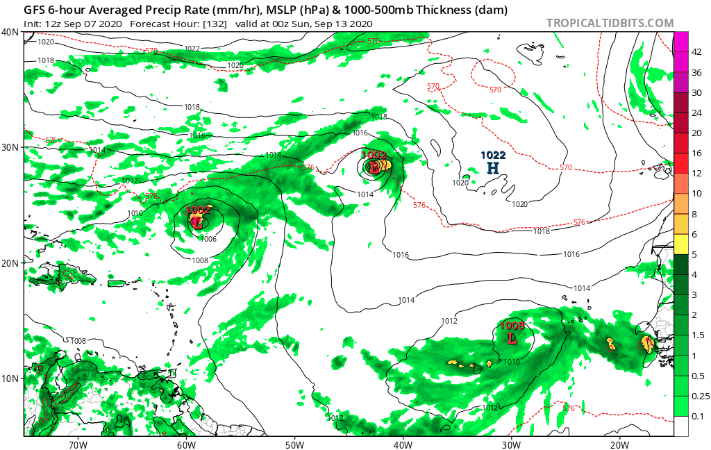
Gets close to Bermuda this run of the 12Z GFS. Animation starts at hour 132, the storms is well NE of the Lesser Antilles.
0 likes

-
Hypercane_Kyle

- Category 5

- Posts: 3465
- Joined: Sat Mar 07, 2015 7:58 pm
- Location: Cape Canaveral, FL
Re: ATL: PAULETTE - Models
12z HWRF makes Paulette nearly into a major hurricane.
1 likes
My posts are my own personal opinion, defer to the National Hurricane Center (NHC) and other NOAA products for decision making during hurricane season.
Re: ATL: PAULETTE - Models
SFLcane wrote:EPS sure is ominous for this TS. A huge westward shift.
Indeed! Here on this 216 hour map of the 12Z EPS, those just offshore the SE US, the TD over FL, and the H in the E GOM are from Paulette:

1 likes
Personal Forecast Disclaimer:
The posts in this forum are NOT official forecasts and should not be used as such. They are just the opinion of the poster and may or may not be backed by sound meteorological data. They are NOT endorsed by any professional institution or storm2k.org. For official information, please refer to the NHC and NWS products.
The posts in this forum are NOT official forecasts and should not be used as such. They are just the opinion of the poster and may or may not be backed by sound meteorological data. They are NOT endorsed by any professional institution or storm2k.org. For official information, please refer to the NHC and NWS products.
-
CrazyC83
- Professional-Met

- Posts: 34316
- Joined: Tue Mar 07, 2006 11:57 pm
- Location: Deep South, for the first time!
Re: ATL: PAULETTE - Models
I suspect these models now seen it too weak initially to influence Rene, escape then intensify north of the islands? Basically a Fran or Floyd scenario?
4 likes
-
Hurricane Mike
- Category 2

- Posts: 675
- Joined: Tue Apr 10, 2018 7:44 am
Re: ATL: PAULETTE - Models
GFS shows Paulette with a donut eye as a likely major hurricane near Bermuda in 7 days or so.
0 likes


-
AutoPenalti
- Category 5
- Posts: 4091
- Age: 29
- Joined: Mon Aug 17, 2015 4:16 pm
- Location: Ft. Lauderdale, Florida
Re: ATL: PAULETTE - Models
Yikes. It’s still within the 10 day range, lots of model
shifts to come.
2 likes
The posts in this forum are NOT official forecasts and should not be used as such. They are just the opinion of the poster and may or may not be backed by sound meteorological data. They are NOT endorsed by any professional institution or STORM2K. For official information, please refer to products from the NHC and NWS.
Model Runs Cheat Sheet:
GFS (5:30 AM/PM, 11:30 AM/PM)
HWRF, GFDL, UKMET, NAVGEM (6:30-8:00 AM/PM, 12:30-2:00 AM/PM)
ECMWF (1:45 AM/PM)
TCVN is a weighted averaged
-
ColdMiser123

- Professional-Met
- Posts: 905
- Age: 29
- Joined: Mon Sep 26, 2016 3:26 pm
- Location: Northeast US
Re: ATL: PAULETTE - Models
There really isn't too much room for error on the 18z GFS evolution for Paulette. A lobe rotating along the main trough axis is the primary reason it goes offshore this run. Can't assume that will happen 7-8 days out being in a very data sparse region.
4 likes
B.S., M.S., Meteorology & Atmospheric Science
Re: ATL: PAULETTE - Models
CrazyC83 wrote:I suspect these models now seen it too weak initially to influence Rene, escape then intensify north of the islands? Basically a Fran or Floyd scenario?
I could see that as a possibility. I think we'll get further west shifts before recurvature as the models get a better grip on the interaction between Paulette and Rene, which was obviously overdone. I'm curious what next set of ensembles will show, they've been creeping westwards already.
1 likes
Andrew (1992), Irene (1999), Frances (2004), Katrina (2005), Wilma (2005), Fay (2008), Irma (2017), Eta (2020), Ian (2022)
Re: ATL: PAULETTE - Models
Yeah...that’s a wee bit too close for comfort on the 18z rum.
0 likes
Irene '11 Sandy '12 Hermine '16 5/15/2018 Derecho Fay '20 Isaias '20 Elsa '21 Henri '21 Ida '21
I am only a meteorology enthusiast who knows a decent amount about tropical cyclones. Look to the professional mets, the NHC, or your local weather office for the best information.
I am only a meteorology enthusiast who knows a decent amount about tropical cyclones. Look to the professional mets, the NHC, or your local weather office for the best information.
Re: ATL: PAULETTE - Models
more fuel to the fire 
GEFS 12Z 18z ENS.....comp
Can I say, slower and farther south????
https://www.tropicaltidbits.com/analysi ... 90718&fh=6
GEFS 12Z 18z ENS.....comp
Can I say, slower and farther south????
https://www.tropicaltidbits.com/analysi ... 90718&fh=6
0 likes


Re: ATL: PAULETTE - Models
Last edited by TJRE on Mon Sep 07, 2020 9:00 pm, edited 1 time in total.
3 likes
-
Hypercane_Kyle
- Category 5
- Posts: 3465
- Joined: Sat Mar 07, 2015 7:58 pm
- Location: Cape Canaveral, FL
Re: ATL: PAULETTE - Models
I have my doubts. We saw with Laura the EPS can incorrectly display the ridge as being too strong.
This one screams OTS to me. Bermuda threat at most.
0 likes
My posts are my own personal opinion, defer to the National Hurricane Center (NHC) and other NOAA products for decision making during hurricane season.
-
AutoPenalti
- Category 5
- Posts: 4091
- Age: 29
- Joined: Mon Aug 17, 2015 4:16 pm
- Location: Ft. Lauderdale, Florida
Re: ATL: PAULETTE - Models
ColdMiser123 wrote:There really isn't too much room for error on the 18z GFS evolution for Paulette. A lobe rotating along the main trough axis is the primary reason it goes offshore this run. Can't assume that will happen 7-8 days out being in a very data sparse region.
Pretty much, but it does show the evolution of a stronger ridge compared to its prior runs. Which isn’t really good news to be quite honest.
1 likes
The posts in this forum are NOT official forecasts and should not be used as such. They are just the opinion of the poster and may or may not be backed by sound meteorological data. They are NOT endorsed by any professional institution or STORM2K. For official information, please refer to products from the NHC and NWS.
Model Runs Cheat Sheet:
GFS (5:30 AM/PM, 11:30 AM/PM)
HWRF, GFDL, UKMET, NAVGEM (6:30-8:00 AM/PM, 12:30-2:00 AM/PM)
ECMWF (1:45 AM/PM)
TCVN is a weighted averaged
Who is online
Users browsing this forum: No registered users and 35 guests