The 0zGFS wants to split this wave in 2 with 2 separate systems, can’t discount that with the pattern but I would think either the northern or southern one would win out and not both. It’s a really odd setup
The Northern system wins out
Central Atlantic Tropical Wave (Is Invest 91L)
Moderator: S2k Moderators
Forum rules

The posts in this forum are NOT official forecasts and should not be used as such. They are just the opinion of the poster and may or may not be backed by sound meteorological data. They are NOT endorsed by any professional institution or STORM2K. For official information, please refer to products from the National Hurricane Center and National Weather Service.
-
Hurricaneman

- Category 5

- Posts: 7404
- Age: 45
- Joined: Tue Aug 31, 2004 3:24 pm
- Location: central florida
-
AJC3

- Admin

- Posts: 4156
- Age: 62
- Joined: Tue Aug 31, 2004 7:04 pm
- Location: Ballston Spa, New York
- Contact:
Re: Tropical Wave SW of the Cabo Verde Islands
Tropical Weather Discussion
NWS National Hurricane Center Miami FL
756 PM EDT Sun Aug 30 2020
...TROPICAL WAVES...
A tropical wave extends from 06N-17N with axis along 31W, moving
W at 10 kt. There is no deep convection associated with the wave
as this time.
NWS National Hurricane Center Miami FL
756 PM EDT Sun Aug 30 2020
...TROPICAL WAVES...
A tropical wave extends from 06N-17N with axis along 31W, moving
W at 10 kt. There is no deep convection associated with the wave
as this time.
0 likes
-
AJC3
- Admin
- Posts: 4156
- Age: 62
- Joined: Tue Aug 31, 2004 7:04 pm
- Location: Ballston Spa, New York
- Contact:
Re: Tropical Wave SW of the Cabo Verde Islands
Tropical Weather Discussion
NWS National Hurricane Center Miami FL
516 UTC Mon Aug 31 2020
...TROPICAL WAVES...
A tropical wave extends from 06N-17N with axis along 32W, moving
W at 10 kt. Isolated moderate convection is within 120 nm of the
wave axis.
NWS National Hurricane Center Miami FL
516 UTC Mon Aug 31 2020
...TROPICAL WAVES...
A tropical wave extends from 06N-17N with axis along 32W, moving
W at 10 kt. Isolated moderate convection is within 120 nm of the
wave axis.
0 likes


Re: Tropical Wave SW of the Cabo Verde Islands
Down to 10%
Gone for good? Or will it respawn when it passes the Lesser Antilles? Granted it keeps its vorticity...
Gone for good? Or will it respawn when it passes the Lesser Antilles? Granted it keeps its vorticity...
4. Another tropical wave is located over the eastern Atlantic Ocean,
several hundred miles southwest of the Cabo Verde Islands. This
system is producing little shower activity, and further development
of this system is not expected.
* Formation chance through 48 hours...low...near 0 percent.
* Formation chance through 5 days...low...10 percent.
several hundred miles southwest of the Cabo Verde Islands. This
system is producing little shower activity, and further development
of this system is not expected.
* Formation chance through 48 hours...low...near 0 percent.
* Formation chance through 5 days...low...10 percent.
0 likes
-
Hurricaneman
- Category 5
- Posts: 7404
- Age: 45
- Joined: Tue Aug 31, 2004 3:24 pm
- Location: central florida
Re: Tropical Wave SW of the Cabo Verde Islands
Ryxn wrote:Down to 10%
Gone for good? Or will it respawn when it passes the Lesser Antilles? Granted it keeps its vorticity...4. Another tropical wave is located over the eastern Atlantic Ocean,
several hundred miles southwest of the Cabo Verde Islands. This
system is producing little shower activity, and further development
of this system is not expected.
* Formation chance through 48 hours...low...near 0 percent.
* Formation chance through 5 days...low...10 percent.
The models are showing this combining with the wave in west Africa, a rare wave merger
2 likes
-
gatorcane

- S2K Supporter

- Posts: 23708
- Age: 48
- Joined: Sun Mar 13, 2005 3:54 pm
- Location: Boca Raton, FL
Re: Tropical Wave SW of the Cabo Verde Islands
SoupBone wrote:gatorcane wrote:12Z CMC animation. The model looks quite bullish, weak steering flow as well:
https://i.postimg.cc/63TvC8ZJ/gem-z850-vort-atl-fh72-240.gif
How do you get these really large model run images?
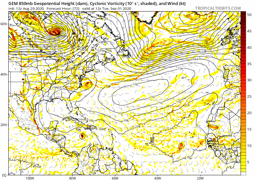
Tropical Tidbits has a “forecast GIF” blue button for each model run where you can specify the start and end hours. The button is on the bottom-right of model image. You can download the file and then upload to an image hosting site like postimage.org before posting here.
0 likes
-
AJC3
- Admin
- Posts: 4156
- Age: 62
- Joined: Tue Aug 31, 2004 7:04 pm
- Location: Ballston Spa, New York
- Contact:
Re: Central Atlantic Tropical Wave (approaching 40W)
Tropical Weather Discussion
NWS National Hurricane Center Miami FL
630 PM EDT Mon Aug 31 2020
...TROPICAL WAVES...
A central Atlantic tropical wave has an axis along 37W from 17N
southward, moving W at 10-15 kt. Scattered moderate convection is
noted from 08N to 10N between 37W and 40W.
NWS National Hurricane Center Miami FL
630 PM EDT Mon Aug 31 2020
...TROPICAL WAVES...
A central Atlantic tropical wave has an axis along 37W from 17N
southward, moving W at 10-15 kt. Scattered moderate convection is
noted from 08N to 10N between 37W and 40W.
0 likes
-
Extratropical94

- Professional-Met

- Posts: 3545
- Age: 31
- Joined: Wed Oct 20, 2010 6:36 am
- Location: Hamburg, Germany
- Contact:
Re: Central Atlantic Tropical Wave
A small area of low pressure has formed about midway between the
Windward Islands and west Africa. Upper-level winds are marginally
conducive for some slow development this week as the system
meanders in the central tropical Atlantic Ocean.
* Formation chance through 48 hours...low...10 percent.
* Formation chance through 5 days...low...20 percent.
Windward Islands and west Africa. Upper-level winds are marginally
conducive for some slow development this week as the system
meanders in the central tropical Atlantic Ocean.
* Formation chance through 48 hours...low...10 percent.
* Formation chance through 5 days...low...20 percent.
0 likes
54° 11' 59'' N, 9° 9' 20'' E
Boomer Sooner!
Go Broncos! Go Cards!
Clinching counties, one at a time: https://mob-rule.com/user-gifs/USA/xtrp94.gif
- Daniel
Boomer Sooner!
Go Broncos! Go Cards!
Clinching counties, one at a time: https://mob-rule.com/user-gifs/USA/xtrp94.gif
- Daniel
-
floridasun78
- Category 5
- Posts: 3755
- Joined: Sun May 17, 2009 10:16 pm
- Location: miami fl
Re: Central Atlantic Tropical Wave
Tropical Weather Outlook NWS National Hurricane Center Miami FL 800 PM EDT Tue Sep 1 20201. Showers and thunderstorms associated with a small area of low pressure about midway between the Windward Islands and west Africa appear to be slowly becoming better organized. Some additional development of this system is possible this week as the system meanders in the central tropical * Formation chance through 48 hours...low...20 percent. Tropical Weather Outlook Atlantic Ocean. * Formation chance through 5 days...low...30 percent.
0 likes
-
floridasun78
- Category 5
- Posts: 3755
- Joined: Sun May 17, 2009 10:16 pm
- Location: miami fl
Re: Central Atlantic Tropical Wave
rea that nhc watching is area by 40w blob:https://www.tropicaltidbits.com/99ad91f8-0f78-48c0-86d6-879d9bbfe123
0 likes
-
cycloneye

- Admin
- Posts: 149734
- Age: 69
- Joined: Thu Oct 10, 2002 10:54 am
- Location: San Juan, Puerto Rico
Re: Central Atlantic Tropical Wave (Is Invest 91L)
1 likes
Visit the Caribbean-Central America Weather Thread where you can find at first post web cams,radars
and observations from Caribbean basin members Click Here
and observations from Caribbean basin members Click Here
Who is online
Users browsing this forum: cycloneye and 135 guests