
2020 WPAC Season
Moderator: S2k Moderators
Forum rules

The posts in this forum are NOT official forecasts and should not be used as such. They are just the opinion of the poster and may or may not be backed by sound meteorological data. They are NOT endorsed by any professional institution or STORM2K. For official information, please refer to products from the National Hurricane Center and National Weather Service.

Re: 2020 WPAC Season
EPS for the rest w/o Maysak

0 likes
ヤンデレ女が寝取られるているのを見たい!!!
ECMWF ensemble NWPAC plots: https://ecmwfensnwpac.imgbb.com/
Multimodel NWPAC plots: https://multimodelnwpac.imgbb.com/
GFS Ensemble NWPAC plots (16 & 35 day forecast): https://gefsnwpac.imgbb.com/
Plots updated automatically
ECMWF ensemble NWPAC plots: https://ecmwfensnwpac.imgbb.com/
Multimodel NWPAC plots: https://multimodelnwpac.imgbb.com/
GFS Ensemble NWPAC plots (16 & 35 day forecast): https://gefsnwpac.imgbb.com/
Plots updated automatically
-
1900hurricane

- Category 5

- Posts: 6063
- Age: 34
- Joined: Fri Feb 06, 2015 12:04 pm
- Location: Houston, TX
- Contact:
Re: 2020 WPAC Season
Even in the most quiet of seasons, this is when things begin to pick up.

1 likes
Contract Meteorologist. TAMU & MSST. Fiercely authentic, one of a kind. We are all given free will, so choose a life meant to be lived. We are the Masters of our own Stories.
Opinions expressed are mine alone.
Follow me on Twitter at @1900hurricane : Read blogs at https://1900hurricane.wordpress.com/
Opinions expressed are mine alone.
Follow me on Twitter at @1900hurricane : Read blogs at https://1900hurricane.wordpress.com/
-
gatorcane

- S2K Supporter

- Posts: 23708
- Age: 48
- Joined: Sun Mar 13, 2005 3:54 pm
- Location: Boca Raton, FL
Re: 2020 WPAC Season
CMC animation of the next possible Typhoon:
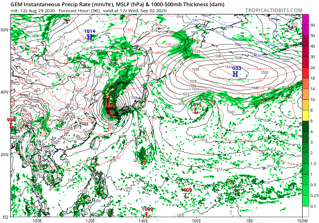
Last edited by gatorcane on Sat Aug 29, 2020 12:40 pm, edited 1 time in total.
0 likes
Re: 2020 WPAC Season
gatorcane wrote:GFS animation of the next possible Typhoon:
https://i.postimg.cc/y8N0XpcS/gem-mslp-pcpn-wpac-fh96-192.gif
Umm but that model animation is from the CMC
0 likes
ヤンデレ女が寝取られるているのを見たい!!!
ECMWF ensemble NWPAC plots: https://ecmwfensnwpac.imgbb.com/
Multimodel NWPAC plots: https://multimodelnwpac.imgbb.com/
GFS Ensemble NWPAC plots (16 & 35 day forecast): https://gefsnwpac.imgbb.com/
Plots updated automatically
ECMWF ensemble NWPAC plots: https://ecmwfensnwpac.imgbb.com/
Multimodel NWPAC plots: https://multimodelnwpac.imgbb.com/
GFS Ensemble NWPAC plots (16 & 35 day forecast): https://gefsnwpac.imgbb.com/
Plots updated automatically
-
gatorcane
- S2K Supporter
- Posts: 23708
- Age: 48
- Joined: Sun Mar 13, 2005 3:54 pm
- Location: Boca Raton, FL
Re: 2020 WPAC Season
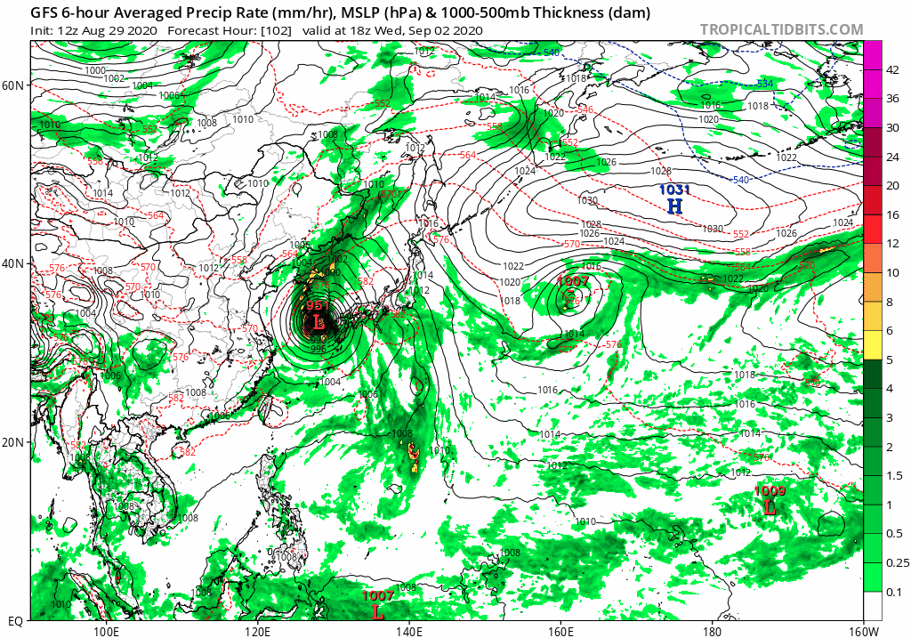
Hayabusa wrote:gatorcane wrote:GFS animation of the next possible Typhoon:
https://i.postimg.cc/y8N0XpcS/gem-mslp-pcpn-wpac-fh96-192.gif
Umm but that model animation is from the CMC
Indeed, nice catch. Here is the GFS:
0 likes
-
mrbagyo

- Category 5
- Posts: 3998
- Age: 33
- Joined: Thu Apr 12, 2012 9:18 am
- Location: 14.13N 120.98E
- Contact:
Re: 2020 WPAC Season
ensemble model is starting to pick up some signal from the lower lats - south of Guam


0 likes
The posts in this forum are NOT official forecast and should not be used as such. They are just the opinion of the poster and may or may not be backed by sound meteorological data. They are NOT endorsed by any professional institution or storm2k.org. For official information, please refer to RSMC, NHC and NWS products.
-
euro6208

-
euro6208
Re: 2020 WPAC Season

Before August, WPAC was at 3/1/1.
Now it's at 10/5/3, unofficially at 10/6/3.
All 6 typhoons made landfall.
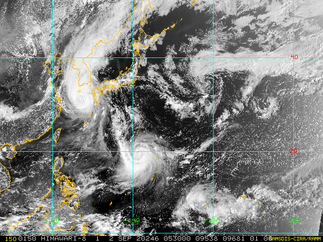
Looking at our 5th straight typhoon and 3rd straight major with future Haishen.
0 likes
-
1900hurricane
- Category 5
- Posts: 6063
- Age: 34
- Joined: Fri Feb 06, 2015 12:04 pm
- Location: Houston, TX
- Contact:
Re: 2020 WPAC Season
ACE at the end of August is 4th lowest to date. Only (in order from most to least) 1977, 1998, and 2010 had lower ACE at the conclusion of August.
0 likes
Contract Meteorologist. TAMU & MSST. Fiercely authentic, one of a kind. We are all given free will, so choose a life meant to be lived. We are the Masters of our own Stories.
Opinions expressed are mine alone.
Follow me on Twitter at @1900hurricane : Read blogs at https://1900hurricane.wordpress.com/
Opinions expressed are mine alone.
Follow me on Twitter at @1900hurricane : Read blogs at https://1900hurricane.wordpress.com/
-
mrbagyo
- Category 5
- Posts: 3998
- Age: 33
- Joined: Thu Apr 12, 2012 9:18 am
- Location: 14.13N 120.98E
- Contact:
Re: 2020 WPAC Season
" [Press release] (R2.9.1) The sea surface temperature is much higher than normal, mainly in the south of Japan, and there are some sea areas where the monthly mean sea surface temperature in August was the highest since 1982, when there is an analysis value. "
https://twitter.com/JMA_kishou/status/1300662779003547648
https://twitter.com/JMA_kishou/status/1300662779003547648
2 likes
The posts in this forum are NOT official forecast and should not be used as such. They are just the opinion of the poster and may or may not be backed by sound meteorological data. They are NOT endorsed by any professional institution or storm2k.org. For official information, please refer to RSMC, NHC and NWS products.


-
doomhaMwx

- Category 5
- Posts: 2495
- Age: 27
- Joined: Tue Apr 18, 2017 4:01 am
- Location: Baguio/Benguet, Philippines
- Contact:
Re: 2020 WPAC Season
mrbagyo wrote:" [Press release] (R2.9.1) The sea surface temperature is much higher than normal, mainly in the south of Japan, and there are some sea areas where the monthly mean sea surface temperature in August was the highest since 1982, when there is an analysis value. "
https://twitter.com/JMA_kishou/status/1300662779003547648?s=20
Now this is a timely press release with models very aggressive for Haishen in that area.
0 likes
Re: 2020 WPAC Season
mrbagyo wrote:" [Press release] (R2.9.1) The sea surface temperature is much higher than normal, mainly in the south of Japan, and there are some sea areas where the monthly mean sea surface temperature in August was the highest since 1982, when there is an analysis value. "
https://twitter.com/JMA_kishou/status/1300662779003547648?s=20
Hmmm


1 likes
ヤンデレ女が寝取られるているのを見たい!!!
ECMWF ensemble NWPAC plots: https://ecmwfensnwpac.imgbb.com/
Multimodel NWPAC plots: https://multimodelnwpac.imgbb.com/
GFS Ensemble NWPAC plots (16 & 35 day forecast): https://gefsnwpac.imgbb.com/
Plots updated automatically
ECMWF ensemble NWPAC plots: https://ecmwfensnwpac.imgbb.com/
Multimodel NWPAC plots: https://multimodelnwpac.imgbb.com/
GFS Ensemble NWPAC plots (16 & 35 day forecast): https://gefsnwpac.imgbb.com/
Plots updated automatically
-
euro6208
Re: 2020 WPAC Season

For week-2, Lastly, TC tools are beginning to indicate elevated probabilities for TC formation to the east of Hainan in the western Pacific in week-2. However, due to a lack of support from ensemble and deterministic guidance at this time, no TC area is included but this area will continue to be monitored in upcoming outlooks.
0 likes
Re: 2020 WPAC Season
Haha another high latitude one? 

0 likes
ヤンデレ女が寝取られるているのを見たい!!!
ECMWF ensemble NWPAC plots: https://ecmwfensnwpac.imgbb.com/
Multimodel NWPAC plots: https://multimodelnwpac.imgbb.com/
GFS Ensemble NWPAC plots (16 & 35 day forecast): https://gefsnwpac.imgbb.com/
Plots updated automatically
ECMWF ensemble NWPAC plots: https://ecmwfensnwpac.imgbb.com/
Multimodel NWPAC plots: https://multimodelnwpac.imgbb.com/
GFS Ensemble NWPAC plots (16 & 35 day forecast): https://gefsnwpac.imgbb.com/
Plots updated automatically
Who is online
Users browsing this forum: No registered users and 124 guests