Central Atlantic Tropical Wave (Is Invest 91L)
Moderator: S2k Moderators
Forum rules
The posts in this forum are NOT official forecasts and should not be used as such. They are just the opinion of the poster and may or may not be backed by sound meteorological data. They are NOT endorsed by any professional institution or STORM2K. For official information, please refer to products from the National Hurricane Center and National Weather Service.
Re: Tropical Wave off the African Coast
Of course it also wouldn't be the first time the models show a TS at 30W heading out to sea and then six days later a solid wave is approaching the islands.
9 likes
-
plasticup
Re: Tropical Wave off the African Coast
Looks like 06z GFS blew this up, but 12z and 18z don't make much of it. I don't see much support from the other models either - am I wrong?
0 likes
- AtlanticWind
- S2K Supporter

- Posts: 1898
- Age: 67
- Joined: Sun Aug 08, 2004 9:57 pm
- Location: Plantation,Fla
Re: Tropical Wave off the African Coast
What is that convection between 35 and 40 degrees, I dont see a wave on the TWD.
0 likes
-
storminabox
- Category 1

- Posts: 263
- Joined: Sun Jul 09, 2017 10:50 pm
-
catskillfire51
- S2K Supporter

- Posts: 480
- Age: 39
- Joined: Sun Aug 26, 2012 5:40 pm
- Location: Lake Jackson, TX
Re: Tropical Wave off the African Coast
The GFS Para on September 12th... hopefully that doesn't come fruition!
0 likes
Re: Tropical Wave off the African Coast
catskillfire51 wrote:The GFS Para on September 12th... hopefully that doesn't come fruition!
Hopefully not! But it takes the oddest track I've ever seen in the Gulf. Approaches New Orleans, stalls just offshore for a day, then tracks due West to Southwest, perfectly tracing the shape of the coastline
0 likes
-
catskillfire51
- S2K Supporter

- Posts: 480
- Age: 39
- Joined: Sun Aug 26, 2012 5:40 pm
- Location: Lake Jackson, TX
Re: Tropical Wave off the African Coast
sma10 wrote:catskillfire51 wrote:The GFS Para on September 12th... hopefully that doesn't come fruition!
Hopefully not! But it takes the oddest track I've ever seen in the Gulf. Approaches New Orleans, stalls just offshore for a day, then tracks due West to Southwest, perfectly tracing the shape of the coastline
Watching the afternoon news today, they were explaining that the cold front was coming through this week and then was going to be pushed out by a strong high pressure ridge coming in from the west and going from south Texas to Tennessee with a positive tilt. Seeing that and this it could make sense.
0 likes
- Hurricaneman
- Category 5

- Posts: 7404
- Age: 45
- Joined: Tue Aug 31, 2004 3:24 pm
- Location: central florida
Re: Tropical Wave SW of the Cabo Verde Islands
I figured out what the GFS is developing in the Bahamas and sending into Long Island, it’s this wave, while the euro does almost nothing with it.
What we thought the last few days developing strong is actually the wave currently over West Africa right behind it
What we thought the last few days developing strong is actually the wave currently over West Africa right behind it
1 likes
- gatorcane
- S2K Supporter

- Posts: 23708
- Age: 48
- Joined: Sun Mar 13, 2005 3:54 pm
- Location: Boca Raton, FL
Re: Tropical Wave SW of the Cabo Verde Islands
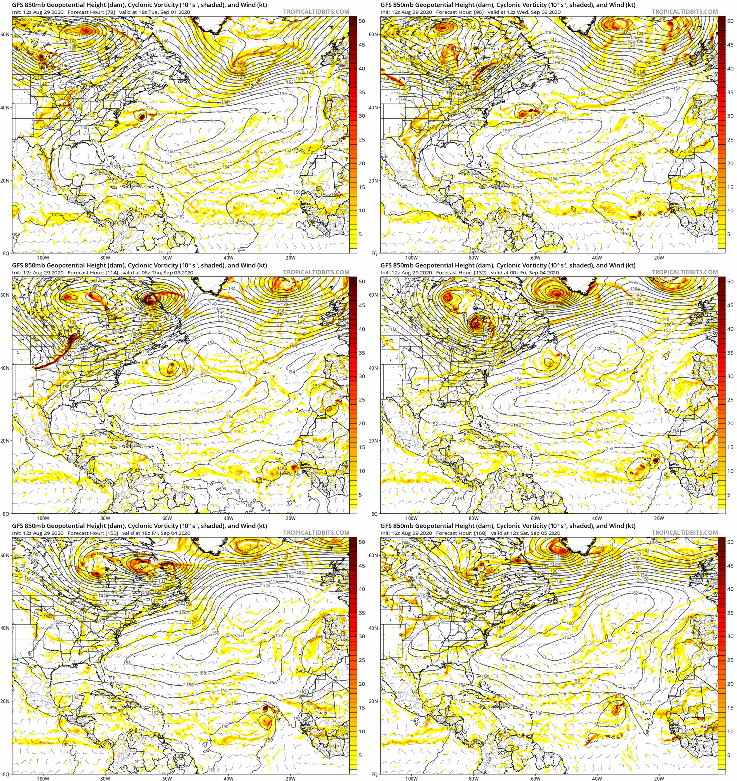
12Z GFS animation from 78 to 168 hours. Looks like the setup for genesis is a little complicated:


0 likes
- gatorcane
- S2K Supporter

- Posts: 23708
- Age: 48
- Joined: Sun Mar 13, 2005 3:54 pm
- Location: Boca Raton, FL
Re: Tropical Wave SW of the Cabo Verde Islands
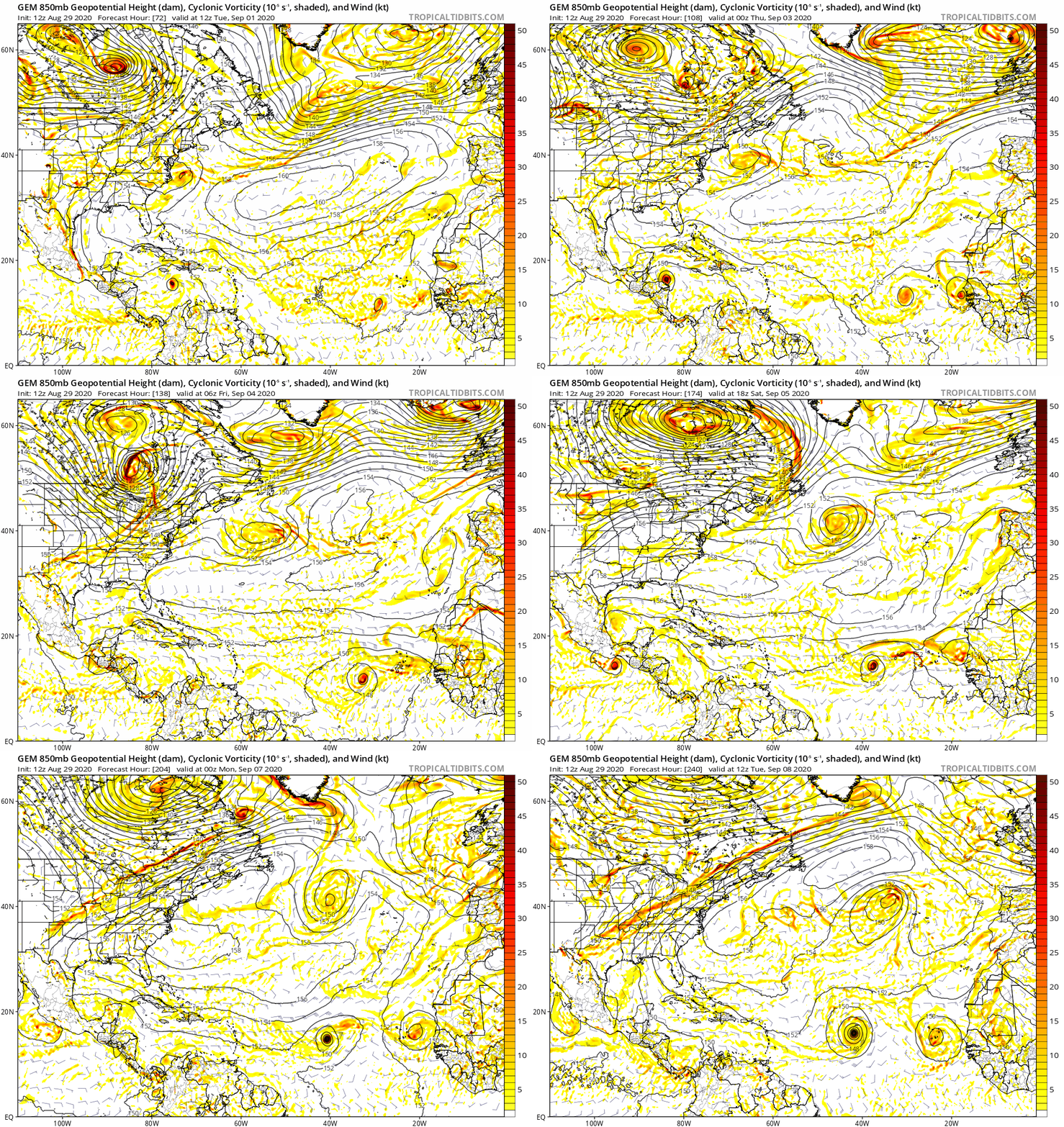
12Z CMC animation. The model looks quite bullish, weak steering flow as well:


0 likes
Re: Tropical Wave SW of the Cabo Verde Islands
gatorcane wrote:12Z CMC animation. The model looks quite bullish, weak steering flow as well:
https://i.postimg.cc/63TvC8ZJ/gem-z850-vort-atl-fh72-240.gif
How do you get these really large model run images?
0 likes
Personal Forecast Disclaimer:
The posts in this forum are NOT official forecast and should not be used as such. They are just the opinion of the poster and may or may not be backed by sound meteorological data. They are NOT endorsed by any professional institution or storm2k.org. For official information, please refer to the NHC and NWS products.
The posts in this forum are NOT official forecast and should not be used as such. They are just the opinion of the poster and may or may not be backed by sound meteorological data. They are NOT endorsed by any professional institution or storm2k.org. For official information, please refer to the NHC and NWS products.
- eastcoastFL
- Category 5

- Posts: 3996
- Age: 44
- Joined: Thu Apr 12, 2007 12:29 pm
- Location: Palm City, FL
Re: Tropical Wave off the African Coast
ConvergenceZone wrote:That’s a weird discussion above. The top part of the wave will be moving rapidly, and the bottom half will be stationary? lol
I think the bottom half is glued to the ITCZ you can see it some model runs. It just can’t move
0 likes
Personal Forecast Disclaimer:
The posts in this forum are NOT official forecast and should not be used as such. They are just the opinion of the poster and may or may not be backed by sound meteorological data. They are NOT endorsed by any professional institution or storm2k.org. For official information, please refer to the NHC and NWS products.
The posts in this forum are NOT official forecast and should not be used as such. They are just the opinion of the poster and may or may not be backed by sound meteorological data. They are NOT endorsed by any professional institution or storm2k.org. For official information, please refer to the NHC and NWS products.
- AnnularCane
- S2K Supporter

- Posts: 2964
- Joined: Thu Jun 08, 2006 9:18 am
- Location: Wytheville, VA
Re: Tropical Wave off the African Coast
eastcoastFL wrote:ConvergenceZone wrote:That’s a weird discussion above. The top part of the wave will be moving rapidly, and the bottom half will be stationary? lol
I think the bottom half is glued to the ITCZ you can see it some model runs. It just can’t move
Yes, I remember the TWOs mentioning that earlier. So how is this going to get unstuck?
1 likes
- eastcoastFL
- Category 5

- Posts: 3996
- Age: 44
- Joined: Thu Apr 12, 2007 12:29 pm
- Location: Palm City, FL
Re: Tropical Wave off the African Coast
AnnularCane wrote:eastcoastFL wrote:ConvergenceZone wrote:That’s a weird discussion above. The top part of the wave will be moving rapidly, and the bottom half will be stationary? lol
I think the bottom half is glued to the ITCZ you can see it some model runs. It just can’t move
Yes, I remember the TWOs mentioning that earlier. So how is this going to get unstuck?
I guess the northern half of the wave axis will beak away.


0 likes
Personal Forecast Disclaimer:
The posts in this forum are NOT official forecast and should not be used as such. They are just the opinion of the poster and may or may not be backed by sound meteorological data. They are NOT endorsed by any professional institution or storm2k.org. For official information, please refer to the NHC and NWS products.
The posts in this forum are NOT official forecast and should not be used as such. They are just the opinion of the poster and may or may not be backed by sound meteorological data. They are NOT endorsed by any professional institution or storm2k.org. For official information, please refer to the NHC and NWS products.
-
curtadams
- S2K Supporter

- Posts: 1122
- Joined: Sun Aug 28, 2005 7:57 pm
- Location: Orange, California
- Contact:
Re: Tropical Wave off the African Coast
gatorcane wrote:120 to 240 hours ECMWF and GFS animations:
ECMWF:
https://i.postimg.cc/jSKJBKdw/ecmwf-uv850-vort-atl-fh120-240.gif
Speaking of the globals being out to sea, as it were, the ECMWF having a tropical storm move off the coast of Mauritania like that is crazy. I don't think anything like that has happened so far north.
0 likes
- AnnularCane
- S2K Supporter

- Posts: 2964
- Joined: Thu Jun 08, 2006 9:18 am
- Location: Wytheville, VA
Re: Tropical Wave SW of the Cabo Verde Islands
0 likes
Re: Tropical Wave SW of the Cabo Verde Islands
SoupBone wrote:gatorcane wrote:12Z CMC animation. The model looks quite bullish, weak steering flow as well:
https://i.postimg.cc/63TvC8ZJ/gem-z850-vort-atl-fh72-240.gif
How do you get these really large model run images?
Regions -> North Atlantic
0 likes
- Hurrilurker
- Category 2

- Posts: 738
- Joined: Mon Jun 09, 2003 3:32 pm
- Location: San Francisco, CA
Re: Tropical Wave SW of the Cabo Verde Islands
Maybe this is just a Gulf storm year...waves just need to traverse the Atlantic and survive weakly, stay south, then blow up south of Cuba.
0 likes
- AnnularCane
- S2K Supporter

- Posts: 2964
- Joined: Thu Jun 08, 2006 9:18 am
- Location: Wytheville, VA
Re: Tropical Wave SW of the Cabo Verde Islands
Hurrilurker wrote:Maybe this is just a Gulf storm year...waves just need to traverse the Atlantic and survive weakly, stay south, then blow up south of Cuba.
These two waves certainly do seem to be in a holding pattern right now. The TWOs almost seem to be copied and pasted.
1 likes
- eastcoastFL
- Category 5

- Posts: 3996
- Age: 44
- Joined: Thu Apr 12, 2007 12:29 pm
- Location: Palm City, FL
Re: Tropical Wave SW of the Cabo Verde Islands
AnnularCane wrote:Hurrilurker wrote:Maybe this is just a Gulf storm year...waves just need to traverse the Atlantic and survive weakly, stay south, then blow up south of Cuba.
These two waves certainly do seem to be in a holding pattern right now. The TWOs almost seem to be copied and pasted.
Looks like it breaks free around 9/5 or 9/6 on gfs. It’s crazy because it just swirls in a loop for a few days before breaking loose. But the tail end of it stays semi attached to the ITCZ for like a week plus until it gets to the islands.
Here’s where it starts it’s escape

Still not 100% free

0 likes
Personal Forecast Disclaimer:
The posts in this forum are NOT official forecast and should not be used as such. They are just the opinion of the poster and may or may not be backed by sound meteorological data. They are NOT endorsed by any professional institution or storm2k.org. For official information, please refer to the NHC and NWS products.
The posts in this forum are NOT official forecast and should not be used as such. They are just the opinion of the poster and may or may not be backed by sound meteorological data. They are NOT endorsed by any professional institution or storm2k.org. For official information, please refer to the NHC and NWS products.
Who is online
Users browsing this forum: Google [Bot] and 316 guests


