Snowcover and other updates!!!!

Winter Weather Discussion

Moderator: S2k Moderators

Forum rules

The posts in this forum are NOT official forecast and should not be used as such. They are just the opinion of the poster and may or may not be backed by sound meteorological data. They are NOT endorsed by any professional institution or STORM2K.

Help Support Storm2K
Message
Author
Guest

Snowcover and other updates!!!!

#1 Postby Guest » Thu Oct 30, 2003 4:58 pm

Below will be the graphics for the Snowcover, NAO, PNA, AO,ENSO...............All of which will be changing in the next couple of weeks as shown by the graphs...................What does it all mean????? More or less imo the SE ridge will hang around for atleast another week and then begin to get beaten down as more and more fronts make thier way down out of Canada (Hence the NAO Possibly headed back negative,PNA leveling out to Positive possible,)...................Big fly in the ointment so to say is the Pac Jet after next week???????? Over all expect the western areas (Plains/Westward) of the USA to stay in the trough (Storminess) for the next week or possibly two which is very much needed with the fire situation out that way.................Eastern areas as i said above should be for the most part under the Ridge with possible exception being the NE????? All in all its around the 15th to the 21st of November when i expect the pattern again will start making another switch with the ridge building back into the West and the trough back in the east......................Somewhere in this time frame (Nov 10th-21st it wouldnt at all suprise me to see a possible severe weather outbreak (OH/TN Valley, And the eastcoast especially from the Mid-Atlantic on south..) as a storm forms along a front what will probably help with the pattern change??????

ENSM NAO Forecast!
Image

ENSM PNA Forecast!
Image

ENSM AO Forecast!
Image

Snowcover Map!
Image

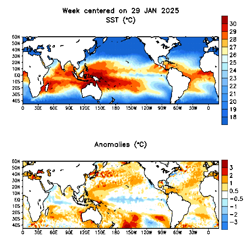
Sea Temps (ENSO Update)
Image


Share your thoughts on all of this and what you think it all means!!!!!
More or less agree or disagree (State why please) that the pattern will change again around the 21st or so???????? IMO i think the pattern change will happen no later then perhaps the week of Thanksgiving at the latest!!!!
0 likes   

GAStorm
Category 1
Category 1
Posts: 364
Joined: Mon Dec 16, 2002 5:26 pm
Location: Marietta, GA

#2 Postby GAStorm » Thu Oct 30, 2003 5:43 pm

Hey KOW,

I have a question about snowcover. Do you think Asia is seeing an above average amount for any particular reason? I think it might be more than last year at this time as well. Hopefully, Canada is next!
0 likes   

User avatar
JCT777
Category 5
Category 5
Posts: 6251
Joined: Mon Oct 14, 2002 9:21 am
Location: Spring Mount, PA
Contact:

#3 Postby JCT777 » Fri Oct 31, 2003 10:15 am

Harry - I agree that the SE ridge will hold for at least the next 10 to 14 days. Afterwards, thing will start to change IMO. I certainly believe that by November 21, most of the east will have temps at or below normal.
0 likes   

Guest

#4 Postby Guest » Wed Nov 12, 2003 10:04 pm

Well as seen today pretty much what i expected back around the first of the month has happend:) I figured there may be a few who would be intrested in this:)
0 likes   

User avatar
Stormsfury
Category 5
Category 5
Posts: 10549
Age: 53
Joined: Wed Feb 05, 2003 6:27 pm
Location: Summerville, SC

#5 Postby Stormsfury » Wed Nov 12, 2003 10:06 pm

Well, I definitely am ...

Also look at the evolution NOW with the EL Niño West Region really beginning to warm up and expand in the last few weeks ...
0 likes   

Guest

#6 Postby Guest » Thu Nov 13, 2003 10:10 am

Oh yes SF! Right now everything is falling right into place as i expected it to a few months back when i did my winter outlook! As of right now as seen by our latest system the storm track is right up thru the lakes as has been a few and even a apps storm and i expect as we get closer to winter and into (Offical) winter the storm track will migrate farther south and east which should bode well for alot of us wanting the snow! Yea there will be those storms in the heart of winter i do expect that will take the trip up the apps and those that take the southern (Supressed) route thru the SE/Southern Mid-Atlantic.............I do think though that yes even the NE/N-Mid Atlantic will get in on one or two of the bigger systems but not like last winter (See my snowfall for cities thread) either way most all should be happy with the way i think this winter will end up!!!!!! I will add as well with the EL'Nino effects and such (Yesterday/Todays system) i think we will see alot stronger systems with more wind/Precip then was had last winter giving a few perhaps a shot or two at a good blizzard this winter!!!!!!!Gonna be one hell of a ride this winter which i for one am really looking forward to!!!!!!!!
0 likes   

User avatar
Stephanie
S2K Supporter
S2K Supporter
Posts: 23843
Age: 62
Joined: Thu Feb 06, 2003 9:53 am
Location: Glassboro, NJ

#7 Postby Stephanie » Thu Nov 13, 2003 10:49 am

Somewhere in this time frame (Nov 10th-21st it wouldnt at all suprise me to see a possible severe weather outbreak (OH/TN Valley, And the eastcoast especially from the Mid-Atlantic on south..) as a storm forms along a front what will probably help with the pattern change??????


Looks like you hit the nail on the head! :)
0 likes   


Return to “Winter Weather”

Who is online

Users browsing this forum: No registered users and 10 guests