ATL: LAURA - Models

Moderator: S2k Moderators

Message
Author
User avatar
Steve
S2K Supporter
S2K Supporter
Posts: 9621
Joined: Sat Apr 05, 2003 11:41 pm
Location: Not a state-caster

Re: ATL: LAURA - Models

#2641 Postby Steve » Sun Aug 23, 2020 1:18 pm

NevadaFan18 wrote:Looks like the main reason the 12z euro is different is because it stalls Marco before landfall. I guess this makes the surrounding environment less favorable. I believe this is the only model that doesn't have Marco making landfall, so this kinda throws a wrench in things


Many of the 12z models don't landfall Marco anymore or they bring him up to the coast and move it slow off to the west to weaken. If you haven't checked him lately, he's become a hurricane again and appears to be outperfoming what a lot of people might have thought - at least for now. Every model I've looked at has a big weakening trend starting tomorrow afternoon. Who knows? This is a first.
1 likes   

User avatar
HouTXmetro
Category 5
Category 5
Posts: 3949
Joined: Sun Jun 13, 2004 6:00 pm
Location: District of Columbia, USA

Re: ATL: LAURA - Models

#2642 Postby HouTXmetro » Sun Aug 23, 2020 1:19 pm

I give up, can we get some consistency here with these models. I can only imagine the headaches it's giving the NHC. Marco was headed to TX then LA/MS now they are talking about stalls and back to TX for Marco... This is beyond frustrating trying to plan accordingly.
6 likes   
[Disclaimer: My Amateur Opinion, please defer to your local authorities or the NHC for Guidance.]

User avatar
chaser1
S2K Supporter
S2K Supporter
Posts: 5475
Age: 64
Joined: Sat Oct 15, 2005 5:59 pm
Location: Longwood, Fl

Re: ATL: LAURA - Models

#2643 Postby chaser1 » Sun Aug 23, 2020 1:19 pm

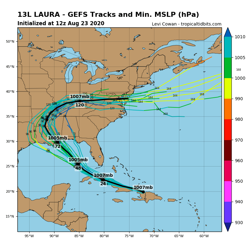
gatorcane wrote:12Z GFS ensembles. Wonder why they are really not making Laura strong? CMC landfalls at 996MB and NAVGEM 989MB. Seems low considering the ideal environment in the Gulf.

https://i.postimg.cc/2S1T0vhV/gfs-ememb-lowlocs-watl-12.png


It's a legit point. I don't think near term land interaction has as much to do with it though. Latest 12 72hr EURO also suggests weaker at landfall too. All models seem pretty much unified on a pretty quick forward speed. Re-alignment issues? If already having a pretty well established vertical core in 48 hr.'s then I'd assume increased strengthening. Only impediment I could possibly make would be the same deep level ridge that's forecast to further extend into the E. GOM. Seems like increasing upper level easterlies might press close to the storm but honestly this seems like it would only act to more strongly vent southerly outflow then impinge outflow.
1 likes   
Andy D

(For official information, please refer to the NHC and NWS products.)

User avatar
gqhebert
Tropical Depression
Tropical Depression
Posts: 51
Age: 50
Joined: Fri Aug 03, 2012 9:38 pm

Re: ATL: LAURA - Models

#2644 Postby gqhebert » Sun Aug 23, 2020 1:20 pm

Euro initializes with Marco as a weak depression- I think that had an impact on this run and scewed the outcome
4 likes   

User avatar
Hypercane_Kyle
Category 5
Category 5
Posts: 3354
Joined: Sat Mar 07, 2015 7:58 pm
Location: Cape Canaveral, FL

Re: ATL: LAURA - Models

#2645 Postby Hypercane_Kyle » Sun Aug 23, 2020 1:21 pm

12z ECMWF also was poorly initialized, perhaps even worse than the 12z GFS. Starts the LLC off northern coast of Haiti. This results in significantly more land interaction
1 likes   
My posts are my own personal opinion, defer to the National Hurricane Center (NHC) and other NOAA products for decision making during hurricane season.

User avatar
Rgv20
S2K Supporter
S2K Supporter
Posts: 2466
Age: 39
Joined: Wed Jan 05, 2011 5:42 pm
Location: Edinburg/McAllen Tx

Re: ATL: LAURA - Models

#2646 Postby Rgv20 » Sun Aug 23, 2020 1:25 pm

Will be interesting to see the 12zECMWF Ensembles later today.
1 likes   
The following post is NOT an official forecast and should not be used as such. It is just the opinion of the poster and may or may not be backed by sound meteorological data. It is NOT endorsed by any professional institution including storm2k.org For Official Information please refer to the NHC and NWS products.

User avatar
Rgv20
S2K Supporter
S2K Supporter
Posts: 2466
Age: 39
Joined: Wed Jan 05, 2011 5:42 pm
Location: Edinburg/McAllen Tx

Re: ATL: LAURA - Models

#2647 Postby Rgv20 » Sun Aug 23, 2020 1:36 pm

12zGFS Para Ensemble are concentrating a landfall area between Corpus and Houston.

Image
6 likes   
The following post is NOT an official forecast and should not be used as such. It is just the opinion of the poster and may or may not be backed by sound meteorological data. It is NOT endorsed by any professional institution including storm2k.org For Official Information please refer to the NHC and NWS products.

User avatar
gatorcane
S2K Supporter
S2K Supporter
Posts: 23691
Age: 47
Joined: Sun Mar 13, 2005 3:54 pm
Location: Boca Raton, FL

Re: ATL: LAURA - Models

#2648 Postby gatorcane » Sun Aug 23, 2020 1:40 pm

12Z GFS ensembles. Consensus (black line):

Image
Last edited by gatorcane on Sun Aug 23, 2020 1:45 pm, edited 3 times in total.
1 likes   

User avatar
Highteeld
Category 5
Category 5
Posts: 2139
Age: 41
Joined: Tue Jan 30, 2018 9:10 pm
Location: Chicago

Re: ATL: LAURA - Models

#2649 Postby Highteeld » Sun Aug 23, 2020 1:42 pm

Rgv20 wrote:12zGFS Para Ensemble are concentrating a landfall area between Corpus and Houston.

https://i.imgur.com/2YaU2LU.png

That seems more reasonable to me
1 likes   
Very useful information on the Dvorak Technique --

https://severe.worldweather.wmo.int/TCF ... kBeven.pdf

stormlover2013

Re: ATL: LAURA - Models

#2650 Postby stormlover2013 » Sun Aug 23, 2020 1:43 pm

gatorcane wrote:12Z GFS ensembles:

https://i.postimg.cc/pr594DYL/13-L-gefs-12z.png


That intialized really bad lol
3 likes   

bohai
Tropical Depression
Tropical Depression
Posts: 76
Age: 65
Joined: Tue Jun 02, 2020 12:57 pm
Location: Comfort, TX

Re: ATL: LAURA - Models

#2651 Postby bohai » Sun Aug 23, 2020 1:43 pm

snoop9928 wrote:We live right on the NW side of the inner loop in Houston. If this keeps looking bad, we may head to Austin to stay with sister in law. We were both in school in Austin back when Ike hit so aren't in tune with when to haul ass out of here. If we left Tuesday would we would screwed with traffic or do you think that's early enough to get out?

We left two days before Rita was supposed to induce 150 mph winds in Katy area. Took 8 hrs to get from Copperfield area to Bellville, about 30 miles away. If expected to bring such heavy winds to a more central H Town area, I would leave Monday morning (assuming a Wednesday hit) or else you will be in traffic. If it does hit H Town hard, I would recommend buying groceries in Austin before heading back.
1 likes   

User avatar
Blinhart
Category 5
Category 5
Posts: 2081
Age: 48
Joined: Thu Sep 08, 2011 3:13 pm
Location: Crowley, La.

Re: ATL: LAURA - Models

#2652 Postby Blinhart » Sun Aug 23, 2020 1:43 pm

gatorcane wrote:12Z GFS ensembles:

https://i.postimg.cc/pr594DYL/13-L-gefs-12z.png


That can't be correct, the center is way SW of that initiation point.
0 likes   
Personal Forecast Disclaimer:
The posts in this forum are NOT official forecast and should not be used as such. They are just the opinion of the poster and may or may not be backed by sound meteorological data. They are NOT endorsed by any professional institution or storm2k.org. For official information, please refer to the NHC and NWS products.

User avatar
HouTXmetro
Category 5
Category 5
Posts: 3949
Joined: Sun Jun 13, 2004 6:00 pm
Location: District of Columbia, USA

Re: ATL: LAURA - Models

#2653 Postby HouTXmetro » Sun Aug 23, 2020 1:43 pm

Ok.... what's the difference between the GEFS ensembles and the GFS Para ensembles? Which is more reliable.
0 likes   
[Disclaimer: My Amateur Opinion, please defer to your local authorities or the NHC for Guidance.]

Nederlander
S2K Supporter
S2K Supporter
Posts: 1250
Joined: Sat Jul 19, 2008 4:28 pm
Location: Conroe, TX

Re: ATL: LAURA - Models

#2654 Postby Nederlander » Sun Aug 23, 2020 1:43 pm

3 likes   

User avatar
SoupBone
Category 5
Category 5
Posts: 3111
Joined: Tue Sep 20, 2005 5:24 pm

Re: ATL: LAURA - Models

#2655 Postby SoupBone » Sun Aug 23, 2020 1:46 pm


Why would they be initiliazing the models repeatedly off of the official center position?
0 likes   
Personal Forecast Disclaimer:
The posts in this forum are NOT official forecast and should not be used as such. They are just the opinion of the poster and may or may not be backed by sound meteorological data. They are NOT endorsed by any professional institution or storm2k.org. For official information, please refer to the NHC and NWS products.

hohnywx
Category 2
Category 2
Posts: 508
Age: 34
Joined: Sun Jul 19, 2009 8:34 pm
Location: Hastings-on-Hudson, NY

Re: ATL: LAURA - Models

#2656 Postby hohnywx » Sun Aug 23, 2020 1:49 pm

gatorcane wrote:12Z GFS ensembles. Consensus (black line):

https://i.postimg.cc/pr594DYL/13-L-gefs-12z.png


I would hazard that this is worthless considering it initialized the storm on the complete opposite side of Hispanola.
1 likes   

User avatar
chaser1
S2K Supporter
S2K Supporter
Posts: 5475
Age: 64
Joined: Sat Oct 15, 2005 5:59 pm
Location: Longwood, Fl

Re: ATL: LAURA - Models

#2657 Postby chaser1 » Sun Aug 23, 2020 1:51 pm

Steve wrote:
NevadaFan18 wrote:Looks like the main reason the 12z euro is different is because it stalls Marco before landfall. I guess this makes the surrounding environment less favorable. I believe this is the only model that doesn't have Marco making landfall, so this kinda throws a wrench in things


Many of the 12z models don't landfall Marco anymore or they bring him up to the coast and move it slow off to the west to weaken. If you haven't checked him lately, he's become a hurricane again and appears to be outperfoming what a lot of people might have thought - at least for now. Every model I've looked at has a big weakening trend starting tomorrow afternoon. Who knows? This is a first.


I'm looking at both the 200mb and broad level shear maps and wonder if they could be overplaying Marco's outflow channel and in fact over projecting an increase in projected vertical shear as a result. The W. GOM trough appears to retrograde with time and upper air conditions actually seem to improve and become more relaxed on final approach to the coast. I concede that a quicker forward track might subject a small delicate core to be more quickly introduced to strong overtaking upper level shear. On a different note, It Marco were to slow down some or track east of forecast, then upper level conditions would be more favorable then forecast. This would be problematic in multiple ways. A stronger Marco might help erode the western extension of the ridge enough to allow Laura to landfall a bit more east then forecast. Assuming that Marco does get shredded by southerly shear, then there'd be hardly much remaining of a surface reflection strong enough to compete against Laura for low level inflow. Ultimately, I think that a weakened Marco would have little to no impact on Laura's track or intensity.
2 likes   
Andy D

(For official information, please refer to the NHC and NWS products.)

User avatar
cheezyWXguy
Category 5
Category 5
Posts: 6108
Joined: Mon Feb 13, 2006 12:29 am
Location: Dallas, TX

Re: ATL: LAURA - Models

#2658 Postby cheezyWXguy » Sun Aug 23, 2020 1:52 pm

hohnywx wrote:
gatorcane wrote:12Z GFS ensembles. Consensus (black line):

https://i.postimg.cc/pr594DYL/13-L-gefs-12z.png


I would hazard that this is worthless considering it initialized the storm on the complete opposite side of Hispanola.

I agree. Normally this difference wouldn’t matter much but it has a huge impact on intensity. Laura may skirt the southern coast of Cuba or even come off of it, and none of the ensembles even entertain the possibility
5 likes   

User avatar
Hypercane_Kyle
Category 5
Category 5
Posts: 3354
Joined: Sat Mar 07, 2015 7:58 pm
Location: Cape Canaveral, FL

Re: ATL: LAURA - Models

#2659 Postby Hypercane_Kyle » Sun Aug 23, 2020 2:12 pm

Last edited by tolakram on Sun Aug 23, 2020 2:13 pm, edited 1 time in total.
Reason: added tweet tags
3 likes   
My posts are my own personal opinion, defer to the National Hurricane Center (NHC) and other NOAA products for decision making during hurricane season.

User avatar
cheezyWXguy
Category 5
Category 5
Posts: 6108
Joined: Mon Feb 13, 2006 12:29 am
Location: Dallas, TX

Re: ATL: LAURA - Models

#2660 Postby cheezyWXguy » Sun Aug 23, 2020 2:15 pm


Some of those on the left end are crazy. Maintaining <980mb all the way to Dallas?
0 likes   


Return to “2020”

Who is online

Users browsing this forum: No registered users and 2 guests