ATL: LAURA - Post-Tropical - Discussion
Moderator: S2k Moderators
- SouthernBreeze
- Category 1

- Posts: 284
- Age: 69
- Joined: Tue Aug 31, 2004 4:54 pm
- Location: SC/NC line- on the SC Coast
Re: ATL: LAURA - Models
I can't wait to see what latitude & what condition she's in after crossing/passing Hispaniola
0 likes
My posts are NOT official forecast and should not be used as such. It's just my opinion and not backed by sound meteorological data, and NOT endorsed by any professional institution or storm2k.org. For official information, please refer to the NHC and NWS products.
grazed by many - most wind damage: Hugo (pre-cellphone days!) & most water: Floyd
grazed by many - most wind damage: Hugo (pre-cellphone days!) & most water: Floyd
- SouthernBreeze
- Category 1

- Posts: 284
- Age: 69
- Joined: Tue Aug 31, 2004 4:54 pm
- Location: SC/NC line- on the SC Coast
Re: ATL: LAURA - Models
If she continues W, looks like she would miss most the island to the S
0 likes
My posts are NOT official forecast and should not be used as such. It's just my opinion and not backed by sound meteorological data, and NOT endorsed by any professional institution or storm2k.org. For official information, please refer to the NHC and NWS products.
grazed by many - most wind damage: Hugo (pre-cellphone days!) & most water: Floyd
grazed by many - most wind damage: Hugo (pre-cellphone days!) & most water: Floyd
- alienstorm
- Category 1

- Posts: 496
- Joined: Tue Jul 31, 2007 1:29 pm
- Location: Miami Fla western suburb
Re: ATL: LAURA - Tropical Storm - Discussion
You can now see clearly banding features on the northside of the storm.
0 likes
Personal Forecast Disclaimer:The posts in this forum are NOT official forecast and should not be used as such. They are just the opinion of the poster and may or may not be backed by sound meteorological data. They are NOT endorsed by any professional institution or storm2k.org. For official information, please refer to the NHC and NWS products.
- eastcoastFL
- Category 5

- Posts: 3996
- Age: 44
- Joined: Thu Apr 12, 2007 12:29 pm
- Location: Palm City, FL
Re: ATL: LAURA - Tropical Storm - Discussion
That mlc is about to pop off shore. I’m not sure if it’s related but convection is getting deeper all over now. I think the HWRF has this blow up and then later it looks like a mess as it moves along the northern coast of Hispaniola and doesn’t really look as good as it does now again until it gets north of Cuba.
2 likes
Personal Forecast Disclaimer:
The posts in this forum are NOT official forecast and should not be used as such. They are just the opinion of the poster and may or may not be backed by sound meteorological data. They are NOT endorsed by any professional institution or storm2k.org. For official information, please refer to the NHC and NWS products.
The posts in this forum are NOT official forecast and should not be used as such. They are just the opinion of the poster and may or may not be backed by sound meteorological data. They are NOT endorsed by any professional institution or storm2k.org. For official information, please refer to the NHC and NWS products.
- ConvergenceZone
- Category 5

- Posts: 5241
- Joined: Fri Jul 29, 2005 1:40 am
- Location: Northern California
Re: ATL: LAURA - Tropical Storm - Discussion
bella_may wrote:https://twitter.com/hurrtrackerapp/status/1297246269073760257?s=21
That tweet is interesting stating to expect some big shifts in Marco's current track. If so, I would think that Laura's track may also shift east.
2 likes
- eastcoastFL
- Category 5

- Posts: 3996
- Age: 44
- Joined: Thu Apr 12, 2007 12:29 pm
- Location: Palm City, FL
Re: ATL: LAURA - Tropical Storm - Discussion
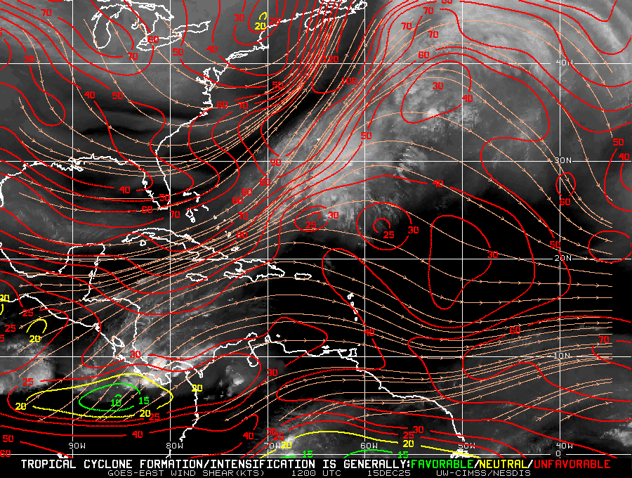
Well here are those favorable conditions we’ve been hearing about from the nhc

3 likes
Personal Forecast Disclaimer:
The posts in this forum are NOT official forecast and should not be used as such. They are just the opinion of the poster and may or may not be backed by sound meteorological data. They are NOT endorsed by any professional institution or storm2k.org. For official information, please refer to the NHC and NWS products.
The posts in this forum are NOT official forecast and should not be used as such. They are just the opinion of the poster and may or may not be backed by sound meteorological data. They are NOT endorsed by any professional institution or storm2k.org. For official information, please refer to the NHC and NWS products.
- ConvergenceZone
- Category 5

- Posts: 5241
- Joined: Fri Jul 29, 2005 1:40 am
- Location: Northern California
Re: ATL: LAURA - Tropical Storm - Discussion
Because of Marco's big east shift expected within the next 20 minutes or so, I would think that would be good news for Laura right? I would think the close proximity now of Laura to Marco would allow the outflow of Marco to disrupt Laura much much more than previously thought due to the close proximity of the systems.
1 likes
- cheezyWXguy
- Category 5

- Posts: 6242
- Joined: Mon Feb 13, 2006 12:29 am
- Location: Dallas, TX
Re: ATL: LAURA - Tropical Storm - Discussion
eastcoastFL wrote:Well here are those favorable conditions we’ve been hearing about from the nhc
http://tropic.ssec.wisc.edu/real-time/atlantic/winds/wg8shr.GIF
Interesting trends on radar. Whatever is left of that circulation that crossed PR is now at the northern coast and velocities are starting to increase again. However, another center appears to be forming of the SW corner of PR. That would make sense, as its pretty close to the center of that anticyclone depicted on the map you posted.
0 likes
Re: ATL: LAURA - Tropical Storm - Discussion
Laura finally is start to look like a tropical storm...and now she's about to get shredded by Hispaniola. I do not see the center reforming further north as the HWRF was showing.
Not out of the woods yet in the Keys, but is starting to look better by the hour. I don't see how Laura is going to miss the shredder now.
Not out of the woods yet in the Keys, but is starting to look better by the hour. I don't see how Laura is going to miss the shredder now.
0 likes
- SouthernBreeze
- Category 1

- Posts: 284
- Age: 69
- Joined: Tue Aug 31, 2004 4:54 pm
- Location: SC/NC line- on the SC Coast
Re: ATL: LAURA - Tropical Storm - Discussion
Since early this AM, cloud flow was showing no west any time soon for Marco.
0 likes
My posts are NOT official forecast and should not be used as such. It's just my opinion and not backed by sound meteorological data, and NOT endorsed by any professional institution or storm2k.org. For official information, please refer to the NHC and NWS products.
grazed by many - most wind damage: Hugo (pre-cellphone days!) & most water: Floyd
grazed by many - most wind damage: Hugo (pre-cellphone days!) & most water: Floyd
- ConvergenceZone
- Category 5

- Posts: 5241
- Joined: Fri Jul 29, 2005 1:40 am
- Location: Northern California
Re: ATL: LAURA - Tropical Storm - Discussion
Jr0d wrote:Laura finally is start to look like a tropical storm...and now she's about to get shredded by Hispaniola. I do not see the center reforming further north as the HWRF was showing.
Not out of the woods yet in the Keys, but is starting to look better by the hour. I don't see how Laura is going to miss the shredder now.
I agree, my attention is on Marco now
0 likes
- eastcoastFL
- Category 5

- Posts: 3996
- Age: 44
- Joined: Thu Apr 12, 2007 12:29 pm
- Location: Palm City, FL
Re: ATL: LAURA - Tropical Storm - Discussion
With the marine map it looks like they just made one giant cone for both storms


6 likes
Personal Forecast Disclaimer:
The posts in this forum are NOT official forecast and should not be used as such. They are just the opinion of the poster and may or may not be backed by sound meteorological data. They are NOT endorsed by any professional institution or storm2k.org. For official information, please refer to the NHC and NWS products.
The posts in this forum are NOT official forecast and should not be used as such. They are just the opinion of the poster and may or may not be backed by sound meteorological data. They are NOT endorsed by any professional institution or storm2k.org. For official information, please refer to the NHC and NWS products.
Re: ATL: LAURA - Tropical Storm - Discussion
Jr0d wrote:Laura finally is start to look like a tropical storm...and now she's about to get shredded by Hispaniola. I do not see the center reforming further north as the HWRF was showing.
Not out of the woods yet in the Keys, but is starting to look better by the hour. I don't see how Laura is going to miss the shredder now.
I think she's in too good of shape to get poofed. After she gets through, she'll have a good opportunity to regain some energy. Where she comes out is going to be the deciding factor IMO. Also, it's hard to predict how Marco's wake effects Laura. There's a ton of unknowns...
0 likes
- FLpanhandle91
- Category 5

- Posts: 1039
- Age: 34
- Joined: Mon Sep 13, 2010 3:50 pm
- Location: Fort Walton Beach, FL
Re: ATL: LAURA - Tropical Storm - Discussion
5:00 PM AST Sat Aug 22
Location: 18.0°N 68.1°W
Moving: W at 18 mph
Min pressure: 1004 mb
Max sustained: 50 mph
Location: 18.0°N 68.1°W
Moving: W at 18 mph
Min pressure: 1004 mb
Max sustained: 50 mph
0 likes
- SouthernBreeze
- Category 1

- Posts: 284
- Age: 69
- Joined: Tue Aug 31, 2004 4:54 pm
- Location: SC/NC line- on the SC Coast
Re: ATL: LAURA - Tropical Storm - Discussion
Im still thinking may skim to south & miss worst of the island - but then still Cuba to encounter
0 likes
My posts are NOT official forecast and should not be used as such. It's just my opinion and not backed by sound meteorological data, and NOT endorsed by any professional institution or storm2k.org. For official information, please refer to the NHC and NWS products.
grazed by many - most wind damage: Hugo (pre-cellphone days!) & most water: Floyd
grazed by many - most wind damage: Hugo (pre-cellphone days!) & most water: Floyd
- alienstorm
- Category 1

- Posts: 496
- Joined: Tue Jul 31, 2007 1:29 pm
- Location: Miami Fla western suburb
Re: ATL: LAURA - Tropical Storm - Discussion
So NHC sticks to the center to the SW and track it over Hispaniola.No center reformation.
1 likes
Personal Forecast Disclaimer:The posts in this forum are NOT official forecast and should not be used as such. They are just the opinion of the poster and may or may not be backed by sound meteorological data. They are NOT endorsed by any professional institution or storm2k.org. For official information, please refer to the NHC and NWS products.
-
supercane4867
- Category 5

- Posts: 4966
- Joined: Wed Nov 14, 2012 10:43 am
Re: ATL: LAURA - Tropical Storm - Discussion
NHC is quite bullish on future intensity in the Gulf.
0 likes
Re: ATL: LAURA - Tropical Storm - Discussion
They send this in just west of Marco about midday Wednesday. 48 hours after Marco roughly...
1 likes
-
TheStormExpert
Re: ATL: LAURA - Tropical Storm - Discussion
It’s weird seeing Hurricane Watches up for the Northern Gulf Coast on the Marco graphic but not Laura.
1 likes
- eastcoastFL
- Category 5

- Posts: 3996
- Age: 44
- Joined: Thu Apr 12, 2007 12:29 pm
- Location: Palm City, FL
Re: ATL: LAURA - Tropical Storm - Discussion
supercane4867 wrote:NHC is quite bullish on future intensity in the Gulf.
They dont show it weakening at all over Hispaniola
INIT 22/2100Z 18.0N 68.1W 45 KT 50 MPH
12H 23/0600Z 18.9N 70.6W 45 KT 50 MPH...INLAND
24H 23/1800Z 20.1N 74.3W 45 KT 50 MPH...INLAND
36H 24/0600Z 21.6N 78.1W 45 KT 50 MPH...INLAND
48H 24/1800Z 23.0N 81.6W 45 KT 50 MPH...INLAND
60H 25/0600Z 24.3N 84.5W 55 KT 65 MPH...OVER WATER
72H 25/1800Z 25.7N 87.3W 65 KT 75 MPH
96H 26/1800Z 29.0N 90.7W 75 KT 85 MPH
120H 27/1800Z 33.0N 91.0W 30 KT 35 MPH...INLAND
0 likes
Personal Forecast Disclaimer:
The posts in this forum are NOT official forecast and should not be used as such. They are just the opinion of the poster and may or may not be backed by sound meteorological data. They are NOT endorsed by any professional institution or storm2k.org. For official information, please refer to the NHC and NWS products.
The posts in this forum are NOT official forecast and should not be used as such. They are just the opinion of the poster and may or may not be backed by sound meteorological data. They are NOT endorsed by any professional institution or storm2k.org. For official information, please refer to the NHC and NWS products.
Who is online
Users browsing this forum: No registered users and 31 guests


