Tropical Wave in Cabo Verde Islands
Moderator: S2k Moderators
Forum rules

The posts in this forum are NOT official forecasts and should not be used as such. They are just the opinion of the poster and may or may not be backed by sound meteorological data. They are NOT endorsed by any professional institution or STORM2K. For official information, please refer to products from the National Hurricane Center and National Weather Service.
-
supercane4867
- Category 5

- Posts: 4966
- Joined: Wed Nov 14, 2012 10:43 am
Re: Strong Tropical Wave over Western Africa
3 systems simultaneously active in late August would be something.
4 likes

Re: Strong Tropical Wave over Western Africa
While we’re all distracted by TD13 and TD14, soon to be 99L is looking pretty good, and for what it’s worth, the GFS develops this in as little as 30 hours. It ends up killing future Nana in the middle of the MDR, however.
0 likes
Irene '11 Sandy '12 Hermine '16 5/15/2018 Derecho Fay '20 Isaias '20 Elsa '21 Henri '21 Ida '21
I am only a meteorology enthusiast who knows a decent amount about tropical cyclones. Look to the professional mets, the NHC, or your local weather office for the best information.
I am only a meteorology enthusiast who knows a decent amount about tropical cyclones. Look to the professional mets, the NHC, or your local weather office for the best information.
-
cycloneye

- Admin

- Posts: 149735
- Age: 69
- Joined: Thu Oct 10, 2002 10:54 am
- Location: San Juan, Puerto Rico
Re: Strong Tropical Wave over Western Africa
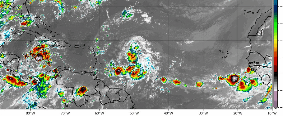
A tropical wave nearing the western Africa coast is producing
disorganized showers and thunderstorms within a few hundred miles of
the coastline. This wave is expected to move over the far eastern
tropical Atlantic on Friday, and some slow development is possible
through the weekend while it moves west-northwestward at 15 to 20
mph across the eastern tropical Atlantic.
* Formation chance through 48 hours...low...20 percent.
* Formation chance through 5 days...medium...40 percent.
0 likes
Visit the Caribbean-Central America Weather Thread where you can find at first post web cams,radars
and observations from Caribbean basin members Click Here
and observations from Caribbean basin members Click Here
Re: Strong Tropical Wave over Western Africa
From that view it looks like it already has a CoC, so could this be classified as TD 15 soon.
2 likes
Personal Forecast Disclaimer:
The posts in this forum are NOT official forecast and should not be used as such. They are just the opinion of the poster and may or may not be backed by sound meteorological data. They are NOT endorsed by any professional institution or storm2k.org. For official information, please refer to the NHC and NWS products.
The posts in this forum are NOT official forecast and should not be used as such. They are just the opinion of the poster and may or may not be backed by sound meteorological data. They are NOT endorsed by any professional institution or storm2k.org. For official information, please refer to the NHC and NWS products.
-
northjaxpro

- S2K Supporter

- Posts: 8900
- Joined: Mon Sep 27, 2010 11:21 am
- Location: Jacksonville, FL
Re: Strong Tropical Wave over Western Africa
Blinhart wrote:From that view it looks like it already has a CoC, so could this be classified as TD 15 soon.
It does. This wave imo just may be the most imptessive in terms of sheer size and organization I have seen emerge off the Africa continent so far this season.
It looks like an established tropicsl cyclone right now.
1 likes
NEVER, EVER SAY NEVER in the tropics and weather in general, and most importantly, with life itself!!
________________________________________________________________________________________
Fay 2008 Beryl 2012 Debby 2012 Colin 2016 Hermine 2016 Julia 2016 Matthew 2016 Irma 2017 Dorian 2019
________________________________________________________________________________________
Fay 2008 Beryl 2012 Debby 2012 Colin 2016 Hermine 2016 Julia 2016 Matthew 2016 Irma 2017 Dorian 2019
-
EquusStorm
- Category 5
- Posts: 1649
- Age: 35
- Joined: Thu Nov 07, 2013 1:04 pm
- Location: Jasper, AL
- Contact:
Re: Strong Tropical Wave emerging West Africa
Chances might have to go up quite a bit at 8 imo

0 likes
Colors of lost purpose on the canvas of irrelevance
Not a meteorologist, in fact more of an idiot than anything. You should probably check with the NHC or a local NWS office for official information.
Not a meteorologist, in fact more of an idiot than anything. You should probably check with the NHC or a local NWS office for official information.
-
TheStormExpert
Re: Strong Tropical Wave emerging West Africa
Looks FAR more impressive than either of the depressions we have right now. 
0 likes
-
cycloneye
- Admin
- Posts: 149735
- Age: 69
- Joined: Thu Oct 10, 2002 10:54 am
- Location: San Juan, Puerto Rico
Re: Strong Tropical Wave emerging West Africa
A tropical wave located near the west coast of Africa is producing
a large area of disorganized showers and thunderstorms. This wave
is expected to move offshore over the far eastern tropical Atlantic
on Friday, and it could become a tropical depression within the
next few days while it moves west-northwestward at 15 to 20 mph
across the eastern tropical Atlantic. Environmental conditions are
expected to become less favorable for development early next week.
Regardless of development, this system will likely bring gusty
winds and heavy rains across portions of the Cabo Verde Islands
this weekend.
* Formation chance through 48 hours...low...20 percent.
* Formation chance through 5 days...medium...50 percent.
0 likes
Visit the Caribbean-Central America Weather Thread where you can find at first post web cams,radars
and observations from Caribbean basin members Click Here
and observations from Caribbean basin members Click Here
-
IsabelaWeather
- Category 1

- Posts: 316
- Age: 36
- Joined: Tue Jul 07, 2020 7:29 am
- Location: Isabela, Puerto Rico
Re: Strong Tropical Wave emerging West Africa
northjaxpro wrote:Blinhart wrote:From that view it looks like it already has a CoC, so could this be classified as TD 15 soon.
It does. This wave imo just may be the most imptessive in terms of sheer size and organization I have seen emerge off the Africa continent so far this season.
It looks like an established tropicsl cyclone right now.
Also interesting is this was looking like a definite fish storm. But now it seems to be moving west now. (judging by the NHC hatched area.)
0 likes
-
Extratropical94

- Professional-Met

- Posts: 3545
- Age: 31
- Joined: Wed Oct 20, 2010 6:36 am
- Location: Hamburg, Germany
- Contact:
Re: Strong Tropical Wave emerging West Africa
2 am TWO is still not up
0 likes
54° 11' 59'' N, 9° 9' 20'' E
Boomer Sooner!
Go Broncos! Go Cards!
Clinching counties, one at a time: https://mob-rule.com/user-gifs/USA/xtrp94.gif
- Daniel
Boomer Sooner!
Go Broncos! Go Cards!
Clinching counties, one at a time: https://mob-rule.com/user-gifs/USA/xtrp94.gif
- Daniel
-
ouragans

- Category 2

- Posts: 501
- Age: 54
- Joined: Sun Jun 12, 2011 12:09 pm
- Location: Abymes, Guadeloupe F.W.I
- Contact:
Re: Strong Tropical Wave emerging West Africa
Let's imagine soon-to-be 99L becomes Laura
2 likes
Personal forecast disclaimer
This post is a personal point of view, not an information. Please refer to official statements for life-threatening decisions.
David '79, Frederic '79, Hugo '89, Iris, Luis & Marilyn '95, Georges '98, Lenny '99, Dean '07, Irma '17, Maria '17, Fiona '22, Philippe '23, Tammy '23
16°13'33.3,"6N -61°36'39.5"W
-
ouragans
- Category 2
- Posts: 501
- Age: 54
- Joined: Sun Jun 12, 2011 12:09 pm
- Location: Abymes, Guadeloupe F.W.I
- Contact:
Re: Strong Tropical Wave emerging West Africa
A tropical wave moving off of the west coast of Africa is producing
a large area of disorganized showers and thunderstorms. This wave
is expected to move farther offshore over the far eastern tropical
Atlantic on Friday, and it could become a tropical depression within
the next few days while it moves west-northwestward at 15 to 20 mph
across the eastern tropical Atlantic. Environmental conditions are
expected to become less favorable for development early next week.
Regardless of development, this system will likely bring gusty winds
across portions of the Cabo Verde Islands this weekend, as well as
heavy rains that could cause flooding.
* Formation chance through 48 hours...low...20 percent.
* Formation chance through 5 days...medium...50 percent.
0 likes
Personal forecast disclaimer
This post is a personal point of view, not an information. Please refer to official statements for life-threatening decisions.
David '79, Frederic '79, Hugo '89, Iris, Luis & Marilyn '95, Georges '98, Lenny '99, Dean '07, Irma '17, Maria '17, Fiona '22, Philippe '23, Tammy '23
16°13'33.3,"6N -61°36'39.5"W
This post is a personal point of view, not an information. Please refer to official statements for life-threatening decisions.
David '79, Frederic '79, Hugo '89, Iris, Luis & Marilyn '95, Georges '98, Lenny '99, Dean '07, Irma '17, Maria '17, Fiona '22, Philippe '23, Tammy '23
16°13'33.3,"6N -61°36'39.5"W
-
Extratropical94
- Professional-Met
- Posts: 3545
- Age: 31
- Joined: Wed Oct 20, 2010 6:36 am
- Location: Hamburg, Germany
- Contact:
Re: Strong Tropical Wave emerging West Africa
Down to 20/40
A tropical wave located just off of the west coast of Africa is
producing a large area of disorganized showers and a few
thunderstorms. This wave is expected to move farther offshore
over the far eastern tropical Atlantic today. Conditions are
expected to be conducive for some development over the next few
days, and the system could become a tropical depression before
environmental conditions become less favorable for development
early next week. This system is forecast to move west-northwestward
at 15 to 20 mph across the eastern tropical Atlantic, and
regardless of development it will likely bring gusty winds across
portions of the Cabo Verde Islands this weekend, as well as heavy
rains that could cause flooding.
* Formation chance through 48 hours...low...20 percent.
* Formation chance through 5 days...medium...40 percent.
3 likes
54° 11' 59'' N, 9° 9' 20'' E
Boomer Sooner!
Go Broncos! Go Cards!
Clinching counties, one at a time: https://mob-rule.com/user-gifs/USA/xtrp94.gif
- Daniel
Boomer Sooner!
Go Broncos! Go Cards!
Clinching counties, one at a time: https://mob-rule.com/user-gifs/USA/xtrp94.gif
- Daniel
-
EquusStorm
- Category 5
- Posts: 1649
- Age: 35
- Joined: Thu Nov 07, 2013 1:04 pm
- Location: Jasper, AL
- Contact:
Re: Strong Tropical Wave between Cabo Verde and West Africa
Convection went poof; really questioned the NHC lowering odds but looks like they were right on the money. Will probably be worth monitoring closer to home though.
1 likes
Colors of lost purpose on the canvas of irrelevance
Not a meteorologist, in fact more of an idiot than anything. You should probably check with the NHC or a local NWS office for official information.
Not a meteorologist, in fact more of an idiot than anything. You should probably check with the NHC or a local NWS office for official information.
-
toad strangler

- S2K Supporter
- Posts: 4546
- Joined: Sun Jul 28, 2013 3:09 pm
- Location: Earth
- Contact:
Re: Strong Tropical Wave between Cabo Verde and West Africa
EquusStorm wrote:Convection went poof; really questioned the NHC lowering odds but looks like they were right on the money. Will probably be worth monitoring closer to home though.
Sleeper Cell
0 likes
My Weather Station
https://www.wunderground.com/dashboard/pws/KFLPORTS603
https://www.wunderground.com/dashboard/pws/KFLPORTS603

Re: Strong Tropical Wave between Cabo Verde and West Africa
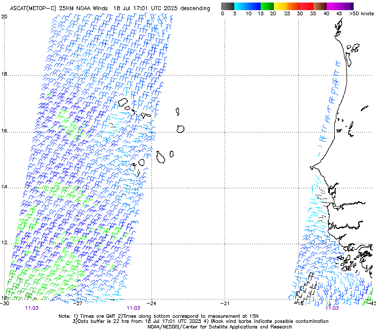
Looking at TPW, it is grabbing a ton of moisture from the ITCZ.
High amplitude too.
Seems like the African Easterly Jet is now back in its normal position but fans out at about 40W.
Normally it diverges at 50W.
So, this will likely stay a wave until it starts to organize around 40W.
Looks like it'll be carrying a large amount of energy with it in terms of high TPW air.
Initial indications appear to be a possible hurricane landfall somewhere TBD.
0 likes
-
cycloneye
- Admin
- Posts: 149735
- Age: 69
- Joined: Thu Oct 10, 2002 10:54 am
- Location: San Juan, Puerto Rico
Re: Tropical Wave in Cabo Verde Islands
Showers and thunderstorms have decreased this morning in associaiton
with a tropical wave near the the Cabo Verde Islands. Additional
development is unlikely to occur as environmental conditions are
expected to become unfavorable as the system moves westward over the
tropical Atlantic.
* Formation chance through 48 hours...low...10 percent.
* Formation chance through 5 days...low...10 percent.
2 likes
Visit the Caribbean-Central America Weather Thread where you can find at first post web cams,radars
and observations from Caribbean basin members Click Here
and observations from Caribbean basin members Click Here
-
TheStormExpert
Re: Tropical Wave in Cabo Verde Islands
NEXT!!!
Tropical Weather Outlook
NWS National Hurricane Center Miami FL
200 PM EDT Sat Aug 22 2020
For the North Atlantic...Caribbean Sea and the Gulf of Mexico:
The National Hurricane Center is issuing advisories on Tropical
Storm Laura, located just south of Puerto Rico, and on
Tropical Storm Marco, located near the Yucatan Channel.
Showers and thunderstorms have diminished this morning in
association with a tropical wave near the the Cabo Verde Islands.
Development is no longer expected to occur as environmental
conditions are forecast to be unfavorable as the system moves
westward over the tropical Atlantic.
* Formation chance through 48 hours...low...near 0 percent.
* Formation chance through 5 days...low...near 0 percent.
0 likes
Who is online
Users browsing this forum: No registered users and 79 guests