ATL: ISAIAS - Models
Moderator: S2k Moderators

-
toad strangler

- S2K Supporter

- Posts: 4546
- Joined: Sun Jul 28, 2013 3:09 pm
- Location: Earth
- Contact:
Re: ATL: INVEST 92L - Models
Looks like GFS is going to miss the meat of the GA's this run. To the N
0 likes
My Weather Station
https://www.wunderground.com/dashboard/pws/KFLPORTS603
https://www.wunderground.com/dashboard/pws/KFLPORTS603
-
HurricaneFrances04
- Category 2

- Posts: 597
- Joined: Mon Jun 25, 2012 8:09 am
- Location: Fort Lauderdale, Florida

-
toad strangler
- S2K Supporter
- Posts: 4546
- Joined: Sun Jul 28, 2013 3:09 pm
- Location: Earth
- Contact:
Re: ATL: INVEST 92L - Models
Probably a fish (to the US) this run
0 likes
My Weather Station
https://www.wunderground.com/dashboard/pws/KFLPORTS603
https://www.wunderground.com/dashboard/pws/KFLPORTS603
-
DorkyMcDorkface

- Category 4

- Posts: 963
- Age: 28
- Joined: Mon Sep 30, 2019 1:32 pm
- Location: Mid-Atlantic
Re: ATL: INVEST 92L - Models
Once again... 
NEW TROPICAL CYCLONE FORECAST TO DEVELOP AFTER 48 HOURS
FORECAST POSITION AT T+ 48 : 13.5N 42.7W
LEAD CENTRAL MAXIMUM WIND
VERIFYING TIME TIME POSITION PRESSURE (MB) SPEED (KNOTS)
-------------- ---- -------- ------------- -------------
1200UTC 27.07.2020 48 13.5N 42.7W 1009 29
0000UTC 28.07.2020 60 14.1N 46.9W 1008 32
1200UTC 28.07.2020 72 14.4N 50.9W 1006 37
0000UTC 29.07.2020 84 15.1N 54.9W 1004 38
1200UTC 29.07.2020 96 17.0N 58.4W 1001 44
0000UTC 30.07.2020 108 18.5N 61.9W 996 49
1200UTC 30.07.2020 120 19.9N 65.6W 989 59
0000UTC 31.07.2020 132 21.7N 68.5W 970 70
1200UTC 31.07.2020 144 23.6N 71.7W 961 71
2 likes
Please note the thougths expressed by this account are solely those of the user and are from a hobbyist perspective. For more comprehensive analysis, consult an actual professional meteorologist or meteorology agency.
Floyd 1999 | Isabel 2003 | Hanna 2008 | Irene 2011 | Sandy 2012 | Isaias 2020
-
stormlover2013
Re: ATL: INVEST 92L - Models
Yep could be fish, ridge vs trough like always, gfs usually over does trough when it’s July-sept
0 likes
-
HurricaneFrances04
- Category 2
- Posts: 597
- Joined: Mon Jun 25, 2012 8:09 am
- Location: Fort Lauderdale, Florida
Re: ATL: INVEST 92L - Models
Well, probably not the pattern you want to see if you live on the East Coast. Still a week out...

3 likes
-
TheHurricaneGod
- Tropical Storm

- Posts: 165
- Age: 23
- Joined: Thu Apr 16, 2020 6:19 pm
- Location: Fort Lauderdale
Re: ATL: INVEST 92L - Models
HurricaneFrances04 wrote:Well, probably not the pattern you want to see if you live on the East Coast. Still a week out...
https://i.imgur.com/IPduu5g.gif
This is the pattern I am worried about for an east coast hit. It was the same pattern that brought Fay up into NYC IIRC.
0 likes
-
toad strangler
- S2K Supporter
- Posts: 4546
- Joined: Sun Jul 28, 2013 3:09 pm
- Location: Earth
- Contact:
Re: ATL: INVEST 92L - Models
Forget a fish, GFS will landfall this run. HP building strongly to the NE
Last edited by toad strangler on Sat Jul 25, 2020 11:30 am, edited 2 times in total.
1 likes
My Weather Station
https://www.wunderground.com/dashboard/pws/KFLPORTS603
https://www.wunderground.com/dashboard/pws/KFLPORTS603
-
supercane4867
- Category 5

- Posts: 4966
- Joined: Wed Nov 14, 2012 10:43 am
-
HurricaneFrances04
- Category 2
- Posts: 597
- Joined: Mon Jun 25, 2012 8:09 am
- Location: Fort Lauderdale, Florida
Re: ATL: INVEST 92L - Models
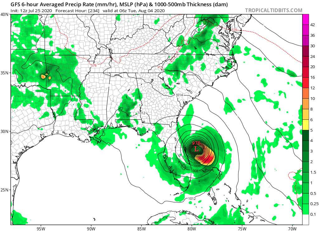
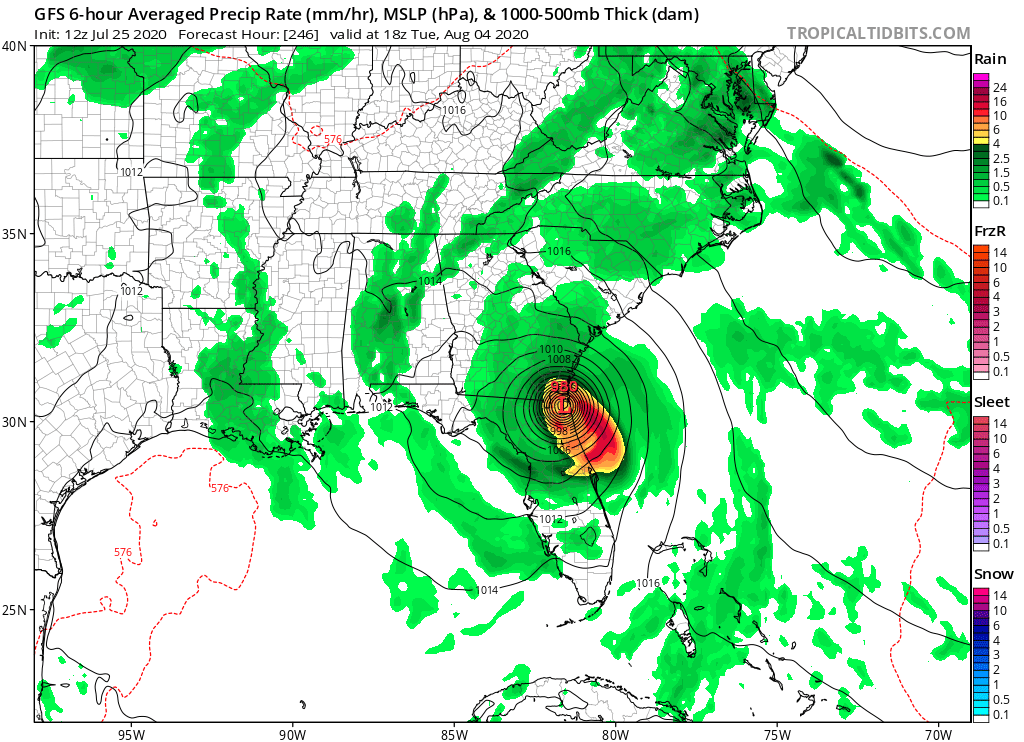
Looks like it might be a East Central Florida hit, with a cruel joke for the Bahamas....
0 likes
Re: ATL: INVEST 92L - Models
toad strangler wrote:Forget a fish, GFS will landfall this run. GA or Carolinas?
Getting those Irma vibes. Recall the GFS was showing GA/SC for landfall and then it started adjusting SW towards Florida...
Still over a week out, but it's the classic ridge vs. trough battle.
Not an official forecast.
3 likes
-
Hurricaneman

- Category 5
- Posts: 7404
- Age: 45
- Joined: Tue Aug 31, 2004 3:24 pm
- Location: central florida
Re: ATL: INVEST 92L - Models
supercane4867 wrote:Appears to be a NC hit given the pattern.
Looks like Offshore Daytona beach and up
0 likes

-
HurricaneFrances04
- Category 2
- Posts: 597
- Joined: Mon Jun 25, 2012 8:09 am
- Location: Fort Lauderdale, Florida

-
toad strangler
- S2K Supporter
- Posts: 4546
- Joined: Sun Jul 28, 2013 3:09 pm
- Location: Earth
- Contact:
Re: ATL: INVEST 92L - Models
500mb such a crapshoot past 5 days. But with a system this strong 500mb means almost everything IRT steering.
0 likes
My Weather Station
https://www.wunderground.com/dashboard/pws/KFLPORTS603
https://www.wunderground.com/dashboard/pws/KFLPORTS603

Re: ATL: INVEST 92L - Models
This one is starting to feel like Irma and Dorian had a baby lol.
1 likes
-
HurricaneFrances04
- Category 2
- Posts: 597
- Joined: Mon Jun 25, 2012 8:09 am
- Location: Fort Lauderdale, Florida
Who is online
Users browsing this forum: No registered users and 62 guests