ATL: HANNA - Remnants - Discussion
Moderator: S2k Moderators
-
DorkyMcDorkface

- Category 4

- Posts: 990
- Age: 28
- Joined: Mon Sep 30, 2019 1:32 pm
- Location: Mid-Atlantic
Re: ATL: EIGHT - Tropical Depression - Discussion
Hmmm....
9 likes
Please note the thougths expressed by this account are solely those of the user and are from a hobbyist perspective. For more comprehensive analysis, consult an actual professional meteorologist or meteorology agency.
Floyd 1999 | Isabel 2003 | Hanna 2008 | Irene 2011 | Sandy 2012 | Isaias 2020
-
Aric Dunn
- Category 5

- Posts: 21238
- Age: 43
- Joined: Sun Sep 19, 2004 9:58 pm
- Location: Ready for the Chase.
- Contact:
Re: ATL: EIGHT - Tropical Depression - Discussion
Much better pass from recon good well defined circ.
should see Hanna shortly.
should see Hanna shortly.
0 likes
Note: If I make a post that is brief. Please refer back to previous posts for the analysis or reasoning. I do not re-write/qoute what my initial post said each time.
If there is nothing before... then just ask
Space & Atmospheric Physicist, Embry-Riddle Aeronautical University,
I believe the sky is falling...
If there is nothing before... then just ask
Space & Atmospheric Physicist, Embry-Riddle Aeronautical University,
I believe the sky is falling...

Re: ATL: EIGHT - Tropical Depression - Discussion
DorkyMcDorkface wrote:Hmmm....
https://uploads.disquscdn.com/images/613fc937e1ce54f187d781056294927053df866f7fcf11ec3225eddc4f381b7c.jpg
Is that the hook Cowan was speaking of earlier?
0 likes


Re: ATL: EIGHT - Tropical Depression - Discussion
DorkyMcDorkface wrote:Hmmm....
https://uploads.disquscdn.com/images/613fc937e1ce54f187d781056294927053df866f7fcf11ec3225eddc4f381b7c.jpg
Definetely has the hook feature.
Interested to see the HWRF & associated models if they stay on that northern track.
1 likes
-
Aric Dunn
- Category 5
- Posts: 21238
- Age: 43
- Joined: Sun Sep 19, 2004 9:58 pm
- Location: Ready for the Chase.
- Contact:
Re: ATL: EIGHT - Tropical Depression - Discussion
Horn1991 wrote:DorkyMcDorkface wrote:Hmmm....
https://uploads.disquscdn.com/images/613fc937e1ce54f187d781056294927053df866f7fcf11ec3225eddc4f381b7c.jpg
Is that the hook Cowan was speaking of earlier?
it is a slightly newer one. but yes.
1 likes
Note: If I make a post that is brief. Please refer back to previous posts for the analysis or reasoning. I do not re-write/qoute what my initial post said each time.
If there is nothing before... then just ask
Space & Atmospheric Physicist, Embry-Riddle Aeronautical University,
I believe the sky is falling...
If there is nothing before... then just ask
Space & Atmospheric Physicist, Embry-Riddle Aeronautical University,
I believe the sky is falling...
-
Hypercane_Kyle

- Category 5
- Posts: 3465
- Joined: Sat Mar 07, 2015 7:58 pm
- Location: Cape Canaveral, FL
Re: ATL: EIGHT - Tropical Depression - Discussion
The Atlantic is absolutely spamming out tropical storms this year. This will beat the record set by Harvey (2005) for earliest 8th named storm by
- 11 days
0 likes
My posts are my own personal opinion, defer to the National Hurricane Center (NHC) and other NOAA products for decision making during hurricane season.
-
plasticup
Re: ATL: EIGHT - Tropical Depression - Discussion
Aric Dunn wrote:Much better pass from recon good well defined circ.
should see Hanna shortly.
That would be 11 days ahead of the 2005 record for 8th earliest storm? People keep pointing out that 2005 had stronger storms but (with the exception of Emily) the strong storms were Aug/Sept/Oct as usual. The absurd pace of cyclogenesis this year is just mind boggling. Every little wisp of cloud stands a chance!
2 likes
-
Shell Mound
- Category 5
- Posts: 2432
- Age: 33
- Joined: Thu Sep 07, 2017 3:39 pm
- Location: St. Petersburg, FL → Scandinavia
Re: ATL: EIGHT - Tropical Depression - Discussion
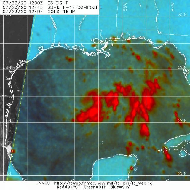
The low-level inflow on visible satellite imagery is rather impressive for a strong depression or low-end tropical storm. The “feathery” cirrus outflow in the western semicircle indicates that the upper low to the southwest is imparting impressive divergence. Additionally, the pronounced band on the northeastern side of the system is often a precursor to rapid intensification, when combined with the formation of a small inner core beneath anticyclonic flow. The overall shape of the system, unfortunately, looks rather similar to that of Harvey ‘17 prior to its rapid pre-shore intensification. I definitely think that this has a better chance to become a hurricane than many people may think or acknowledge. The only negative factor is some northerly shear, but that is abating shortly and rapidly. “Hurricane Hanna”: another year, another “H”-bomb “gone to Texas”...
https://twitter.com/iCyclone/status/1286349831678636032
https://twitter.com/iCyclone/status/1286349831678636032
Last edited by Shell Mound on Thu Jul 23, 2020 12:23 pm, edited 2 times in total.
3 likes
CVW / MiamiensisWx / Shell Mound
The posts in this forum are NOT official forecasts and should not be used as such. They are just the opinion of the poster and may or may not be backed by sound meteorological data. They are NOT endorsed by any professional institution or STORM2K. For official information, please refer to products from the NHC and NWS.

Re: ATL: EIGHT - Tropical Depression - Discussion
dantonlsu wrote:DorkyMcDorkface wrote:Hmmm....
https://uploads.disquscdn.com/images/613fc937e1ce54f187d781056294927053df866f7fcf11ec3225eddc4f381b7c.jpg
Definetely has the hook feature.
Interested to see the HWRF & associated models if they stay on that northern track.
12z HWRF looks like Rockport landfall, just a tad further south than the 06z
0 likes

Re: ATL: EIGHT - Tropical Depression - Discussion
plasticup wrote:Aric Dunn wrote:Much better pass from recon good well defined circ.
should see Hanna shortly.
That would be 11 days ahead of the 2005 record for 8th earliest storm? People keep pointing out that 2005 had stronger storms but (with the exception of Emily) the strong storms were Aug/Sept/Oct as usual. The absurd pace of cyclogenesis this year is just mind boggling. Every little wisp of cloud stands a chance!
Dennis was a major, and Cindy was a borderline 1.
1 likes
-
CyclonicFury

- Category 5
- Posts: 2032
- Age: 27
- Joined: Sun Jul 02, 2017 12:32 pm
- Location: NC
- Contact:
Re: ATL: EIGHT - Tropical Depression - Discussion
Shell Mound wrote:The low-level inflow on visible satellite imagery is rather impressive for a strong depression or low-end tropical storm. The “feathery” cirrus outflow in the western semicircle indicates that the upper low to the southwest is imparting impressive divergence. Additionally, the pronounced band on the northeastern side of the system is often a precursor to rapid intensification, when combined with the formation of a small inner core beneath anticyclonic flow. The overall shape of the system, unfortunately, looks rather similar to that of Harvey ‘17 prior to its rapid pre-shore intensification. I definitely think that this has a better chance to become a hurricane than many people may think or acknowledge. The only negative factor is some northerly shear, but that is abating shortly and rapidly. “Hurricane Hanna”: another year, another “H”-bomb “gone to Texas”...
I wouldn't rule out a minimal Category 1 before landfall but I don't think this will get any stronger than that at most. Most likely I think it will be a strong TS.
2 likes
NCSU B.S. in Meteorology Class of 2021. Tropical weather blogger at http://www.cyclonicfury.com. My forecasts and thoughts are NOT official, for official forecasts please consult the National Hurricane Center.
-
Shell Mound
- Category 5
- Posts: 2432
- Age: 33
- Joined: Thu Sep 07, 2017 3:39 pm
- Location: St. Petersburg, FL → Scandinavia
Re: ATL: EIGHT - Tropical Depression - Discussion
CyclonicFury wrote:Shell Mound wrote:The low-level inflow on visible satellite imagery is rather impressive for a strong depression or low-end tropical storm. The “feathery” cirrus outflow in the western semicircle indicates that the upper low to the southwest is imparting impressive divergence. Additionally, the pronounced band on the northeastern side of the system is often a precursor to rapid intensification, when combined with the formation of a small inner core beneath anticyclonic flow. The overall shape of the system, unfortunately, looks rather similar to that of Harvey ‘17 prior to its rapid pre-shore intensification. I definitely think that this has a better chance to become a hurricane than many people may think or acknowledge. The only negative factor is some northerly shear, but that is abating shortly and rapidly. “Hurricane Hanna”: another year, another “H”-bomb “gone to Texas”...
I wouldn't rule out a minimal Category 1 before landfall but I don't think this will get any stronger than that at most. Most likely I think it will be a strong TS.
Personally, I think a moderate to strong Cat-1 is quite doable, given current trends, if a small inner core can establish itself in time. Analog: Humberto ‘07.
0 likes
CVW / MiamiensisWx / Shell Mound
The posts in this forum are NOT official forecasts and should not be used as such. They are just the opinion of the poster and may or may not be backed by sound meteorological data. They are NOT endorsed by any professional institution or STORM2K. For official information, please refer to products from the NHC and NWS.

Re: ATL: EIGHT - Tropical Depression - Discussion
Shell Mound wrote:The low-level inflow on visible satellite imagery is rather impressive for a strong depression or low-end tropical storm. The “feathery” cirrus outflow in the western semicircle indicates that the upper low to the southwest is imparting impressive divergence. Additionally, the pronounced band on the northeastern side of the system is often a precursor to rapid intensification, when combined with the formation of a small inner core beneath anticyclonic flow. The overall shape of the system, unfortunately, looks rather similar to that of Harvey ‘17 prior to its rapid pre-shore intensification. I definitely think that this has a better chance to become a hurricane than many people may think or acknowledge. The only negative factor is some northerly shear, but that is abating shortly and rapidly. “Hurricane Hanna”: another year, another “H”-bomb “gone to Texas”...
https://twitter.com/iCyclone/status/1286349831678636032
Corpus Christi is a 9 hour drive from Bay St. Louis, unless he's flying to get there.
0 likes
Personal Forecast Disclaimer:
The posts in this forum are NOT official forecast and should not be used as such. They are just the opinion of the poster and may or may not be backed by sound meteorological data. They are NOT endorsed by any professional institution or storm2k.org. For official information, please refer to the NHC and NWS products.
The posts in this forum are NOT official forecast and should not be used as such. They are just the opinion of the poster and may or may not be backed by sound meteorological data. They are NOT endorsed by any professional institution or storm2k.org. For official information, please refer to the NHC and NWS products.
Re: ATL: EIGHT - Tropical Depression - Discussion
Shell Mound wrote:CyclonicFury wrote:Shell Mound wrote:The low-level inflow on visible satellite imagery is rather impressive for a strong depression or low-end tropical storm. The “feathery” cirrus outflow in the western semicircle indicates that the upper low to the southwest is imparting impressive divergence. Additionally, the pronounced band on the northeastern side of the system is often a precursor to rapid intensification, when combined with the formation of a small inner core beneath anticyclonic flow. The overall shape of the system, unfortunately, looks rather similar to that of Harvey ‘17 prior to its rapid pre-shore intensification. I definitely think that this has a better chance to become a hurricane than many people may think or acknowledge. The only negative factor is some northerly shear, but that is abating shortly and rapidly. “Hurricane Hanna”: another year, another “H”-bomb “gone to Texas”...
I wouldn't rule out a minimal Category 1 before landfall but I don't think this will get any stronger than that at most. Most likely I think it will be a strong TS.
Personally, I think a moderate to strong Cat-1 is quite doable, given current trends, if a small inner core can establish itself in time. Analog: Humberto ‘07.
Hurricane models agree with you. You could see if it crawls the coast or moves WSW down the coast, maybe. If it had another day, I'd say it would be more likely. I think 55-60mph is probably the ceiling the way things look now.
2 likes
-
Aric Dunn
- Category 5
- Posts: 21238
- Age: 43
- Joined: Sun Sep 19, 2004 9:58 pm
- Location: Ready for the Chase.
- Contact:
Re: ATL: EIGHT - Tropical Depression - Discussion
Anyone rulling out a Hurricane is likely going to eating their words.
3 likes
Note: If I make a post that is brief. Please refer back to previous posts for the analysis or reasoning. I do not re-write/qoute what my initial post said each time.
If there is nothing before... then just ask
Space & Atmospheric Physicist, Embry-Riddle Aeronautical University,
I believe the sky is falling...
If there is nothing before... then just ask
Space & Atmospheric Physicist, Embry-Riddle Aeronautical University,
I believe the sky is falling...
Re: ATL: EIGHT - Tropical Depression - Discussion
If they go with Hanna it will be this evening or tonight:
1:00 PM CDT Thu Jul 23
Location: 26.0°N 90.3°W
Moving: WNW at 7 mph
Min pressure: 1008 mb
Max sustained: 35 mph
Location: 26.0°N 90.3°W
Moving: WNW at 7 mph
Min pressure: 1008 mb
Max sustained: 35 mph
0 likes
Re: ATL: EIGHT - Tropical Depression - Discussion
Aric Dunn wrote:Anyone rulling out a Hurricane is likely going to eating their words.
I don't think anyone is ruling it out. I'm certainly not, but I don't think it's as likely - not yet anyway and not moderate to strong Cat 1 which is what he said. You and I were posting about it on Monday, and Thursday always seemed to be the day that the models agreed this would come together. I think it's on track for that. .
3 likes

Re: ATL: EIGHT - Tropical Depression - Discussion
Aric Dunn wrote:Anyone rulling out a Hurricane is likely going to eating their words.
Heard crow tastes good when cooked on the BGE.
In fact everything tastes good from the BGE.
https://www.youtube.com/watch?v=51tCC0118VQ
5 likes
Re: ATL: EIGHT - Tropical Depression - Discussion
Here comes the rain again, falling on my head like a memory...
https://radar.weather.gov/ridge/radar.p ... 1&loop=yes
https://radar.weather.gov/ridge/radar.p ... 1&loop=yes
3 likes
-
gatorcane

- S2K Supporter

- Posts: 23708
- Age: 48
- Joined: Sun Mar 13, 2005 3:54 pm
- Location: Boca Raton, FL
Re: ATL: EIGHT - Tropical Depression - Discussion
cycloneye wrote:https://twitter.com/TropicalTidbits/status/1286323620218888192
Agree with Levi here. The convection may be impressive, but looking at the satellite loops, doesn’t look like the low-level center is aligned with the mid-level not to mention, the low is broad. This system will probably go down as “if it only had another 24-48 hours over water what would have been.”
For now looks like a rain event with some TS winds confined to a small area.
2 likes
Who is online
Users browsing this forum: No registered users and 94 guests