Low over the NW GOMEX (Is Invest 90L)
Moderator: S2k Moderators
Forum rules
The posts in this forum are NOT official forecasts and should not be used as such. They are just the opinion of the poster and may or may not be backed by sound meteorological data. They are NOT endorsed by any professional institution or STORM2K. For official information, please refer to products from the National Hurricane Center and National Weather Service.
-
USTropics
- Professional-Met

- Posts: 2741
- Joined: Sun Aug 12, 2007 3:45 am
- Location: Florida State University
Re: Inverted trough over the eastern GOMEX
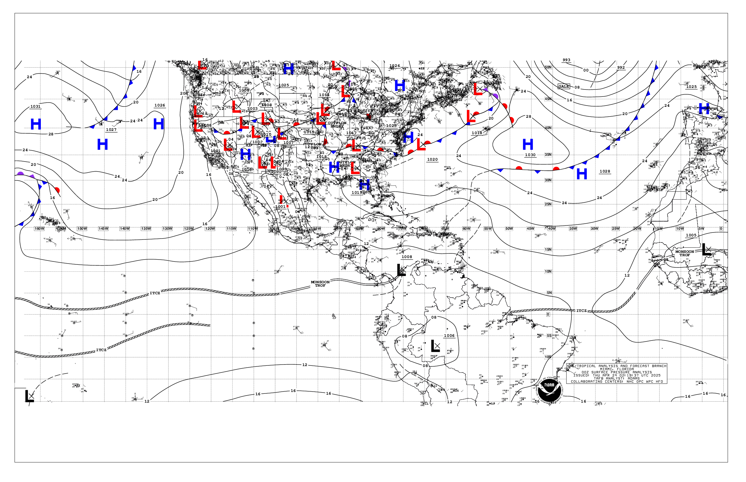
The NHC is also not attaching this to the wave axis in their surface analysis:


2 likes
-
Monsoonjr99
- Tropical Storm

- Posts: 210
- Age: 26
- Joined: Fri Sep 21, 2018 11:22 pm
- Location: Inland Empire, SoCal
Re: Inverted trough over the eastern GOMEX
AJC3 wrote:Minor quibble. This is more of a "pseudo" tropical wave, which is why, when I took the liberty of re-titling the thread, I used "inverted trough" instead of "tropical wave". In spite of offices adjacent to ours having called this feature a t-wave in their AFDs, it's really not. It's origin is a low level vort lobe that broke off an old frontal boundary over the western Atlantic a few days ago and then moved across south Florida Fri night into early Saturday morning. I realize some folks, even professional mets, like to play fast and loose with the terms "easterly wave" and "tropical wave", since In terms of sensibile weather effects, there's not a whole lot of difference (although true AEWs tend to be more robust). I reserve the term "topical wave" for true AEWs.
Didn't Erin last year form from something similar to this?
0 likes
The posts in this forum are NOT official forecasts and should not be used as such. They are just the opinion of the poster and may or may not be backed by sound meteorological data. They are NOT endorsed by any professional institution or STORM2K. For official information, please refer to products from the NHC and NWS.
Some Californian who codes things and tracks weather.
Kay '22, Hilary '23
- AJC3
- Admin

- Posts: 4156
- Age: 62
- Joined: Tue Aug 31, 2004 7:04 pm
- Location: Ballston Spa, New York
- Contact:
Re: Inverted trough over the eastern GOMEX
Monsoonjr99 wrote:AJC3 wrote:Minor quibble. This is more of a "pseudo" tropical wave, which is why, when I took the liberty of re-titling the thread, I used "inverted trough" instead of "tropical wave". In spite of offices adjacent to ours having called this feature a t-wave in their AFDs, it's really not. It's origin is a low level vort lobe that broke off an old frontal boundary over the western Atlantic a few days ago and then moved across south Florida Fri night into early Saturday morning. I realize some folks, even professional mets, like to play fast and loose with the terms "easterly wave" and "tropical wave", since In terms of sensibile weather effects, there's not a whole lot of difference (although true AEWs tend to be more robust). I reserve the term "topical wave" for true AEWs.
Didn't Erin last year form from something similar to this?
Different synoptic setup, but there was obvious baroclnic initiation/forcing given the latitude of Erin's genesis (31.7N)
1 likes
- TheProfessor
- Professional-Met

- Posts: 3506
- Age: 29
- Joined: Tue Dec 03, 2013 10:56 am
- Location: Wichita, Kansas
Re: Inverted trough over the eastern GOMEX
Steve wrote:South Texas Storms wrote:Well this thread doesn't look like it's about the tropical wave in the eastern Gulf...
This wave has lower development chances than the one behind it. This wave just looks to help enhance rainfall across southeast TX and LA early next week.
Yeah, we were just tripping on some marmalade skies. Haha. Anyway, I didn't think the second low was going to do anything either. But the next surge is aimed for the SC/SW LA Coast. I thought this might be the energy ICON was closing off near SWLA earlier in the week and then gradually shifted it a little south and west toward the TX Coast. General flow out of the SE is across the Gulf. What's weird about ICON's rainfall depictions is that it all stays almost offshore. I'm not buying into that completely. It currently closes off a weak low south of Houma on Wednesday night, moves it toward Galveston and then up toward Dallas. Looks pretty insignificant, but it could keep things cloudy and temperatures down across the central and western Gulf this week.
ICON Rainfall Depiction through next Sunday morning (180 hours)
https://www.tropicaltidbits.com/analysi ... 900&fh=180
GFS through 180
https://www.tropicaltidbits.com/analysi ... 900&fh=180
CMC through 180
https://www.tropicaltidbits.com/analysi ... 900&fh=180
Here's HRRR IR Sim through 18 hours showing a lot of popup storms on the IR tomorrow.
https://www.tropicaltidbits.com/analysi ... 1904&fh=18
This is something I've noticed that the ICON does consistently over the years. Precipitation will just cut off right up against land. I wouldn't focus on the model's QPF totals, just that it's showing something producing precipitation in the northwest Gulf. The Canadian ensembles are picking this up again as well.
3 likes
An alumnus of The Ohio State University.
Your local National Weather Service office is your best source for weather information.
Your local National Weather Service office is your best source for weather information.
-
Aric Dunn
- Category 5

- Posts: 21238
- Age: 43
- Joined: Sun Sep 19, 2004 9:58 pm
- Location: Ready for the Chase.
- Contact:
Re: Inverted trough over the central GOMEX
On a side note.. the low level vorticity this morning has increased quite a bit.
Some broad rotation noted in the low levels. Looks like it needs to be watched

Some broad rotation noted in the low levels. Looks like it needs to be watched

1 likes
Note: If I make a post that is brief. Please refer back to previous posts for the analysis or reasoning. I do not re-write/qoute what my initial post said each time.
If there is nothing before... then just ask
Space & Atmospheric Physicist, Embry-Riddle Aeronautical University,
I believe the sky is falling...
If there is nothing before... then just ask
Space & Atmospheric Physicist, Embry-Riddle Aeronautical University,
I believe the sky is falling...
- toad strangler
- S2K Supporter

- Posts: 4546
- Joined: Sun Jul 28, 2013 3:09 pm
- Location: Earth
- Contact:
Re: Inverted trough over the central GOMEX
Awesome stuff AJC3 .... do you work for NWS MLB??
1 likes
My Weather Station
https://www.wunderground.com/dashboard/pws/KFLPORTS603
https://www.wunderground.com/dashboard/pws/KFLPORTS603
Re: Inverted trough over the central GOMEX
Looks like a weak wave passing through with a little extra t-storm activity from the shear that’s not depicted on the maps. Time to go cut the grass before pop ups begin, oh yeah and harvest the tangerine and strawberries.
http://tropic.ssec.wisc.edu/real-time/atlantic/winds/wg8sht.GIF
http://tropic.ssec.wisc.edu/real-time/atlantic/winds/wg8sht.GIF
0 likes
The following post is NOT an official forecast and should not be used as such. It is just the opinion of the poster and may or may not be backed by sound meteorological data. It is NOT endorsed by any professional institution including storm2k.org For Official Information please refer to the NHC and NWS products.
Re: Inverted trough over the central GOMEX
We're about to get that leading edge in an hour or so.
https://www.weather.gov/lix/
Biggest effects per the 12Z HRRR will be cloud cover and precipitation over SWLA/SETX.
https://www.weather.gov/lix/
https://www.weather.gov/lix/
Biggest effects per the 12Z HRRR will be cloud cover and precipitation over SWLA/SETX.
https://www.weather.gov/lix/
0 likes
-
Aric Dunn
- Category 5

- Posts: 21238
- Age: 43
- Joined: Sun Sep 19, 2004 9:58 pm
- Location: Ready for the Chase.
- Contact:
Re: Inverted trough over the central GOMEX
The trough continues to sharpen. if convection keeps doing this it might try to make a run at it.
surface obs showing the "inverted" V very nicely.
visible showing some easterly moving low clouds just to the south of surface obs.
Meso scale models are 50/50 with something trying to get going.


surface obs showing the "inverted" V very nicely.
visible showing some easterly moving low clouds just to the south of surface obs.
Meso scale models are 50/50 with something trying to get going.


1 likes
Note: If I make a post that is brief. Please refer back to previous posts for the analysis or reasoning. I do not re-write/qoute what my initial post said each time.
If there is nothing before... then just ask
Space & Atmospheric Physicist, Embry-Riddle Aeronautical University,
I believe the sky is falling...
If there is nothing before... then just ask
Space & Atmospheric Physicist, Embry-Riddle Aeronautical University,
I believe the sky is falling...
-
Aric Dunn
- Category 5

- Posts: 21238
- Age: 43
- Joined: Sun Sep 19, 2004 9:58 pm
- Location: Ready for the Chase.
- Contact:
Re: Inverted trough over the central GOMEX
Here is a version of the HRRR in 24 hours. borderline TS. saw a couple of wind barbs at TS strength.


1 likes
Note: If I make a post that is brief. Please refer back to previous posts for the analysis or reasoning. I do not re-write/qoute what my initial post said each time.
If there is nothing before... then just ask
Space & Atmospheric Physicist, Embry-Riddle Aeronautical University,
I believe the sky is falling...
If there is nothing before... then just ask
Space & Atmospheric Physicist, Embry-Riddle Aeronautical University,
I believe the sky is falling...
Re: Inverted trough over the central GOMEX
Yeah, it looks like the conditions get better as it get to or inland in Texas in a couple days. I don't think it will get a classification, but it's a decent little system. It's pretty breezy here teens gusting to +/- 20.
1 likes
-
Aric Dunn
- Category 5

- Posts: 21238
- Age: 43
- Joined: Sun Sep 19, 2004 9:58 pm
- Location: Ready for the Chase.
- Contact:
Re: Inverted trough over the central GOMEX
davidiowx wrote:Looks interesting on visible..
Yeah. convection continues to expand and slowly organize.
I would not write this off.. vorticity continues to increase.
2 likes
Note: If I make a post that is brief. Please refer back to previous posts for the analysis or reasoning. I do not re-write/qoute what my initial post said each time.
If there is nothing before... then just ask
Space & Atmospheric Physicist, Embry-Riddle Aeronautical University,
I believe the sky is falling...
If there is nothing before... then just ask
Space & Atmospheric Physicist, Embry-Riddle Aeronautical University,
I believe the sky is falling...
- MississippiWx
- S2K Supporter

- Posts: 1720
- Joined: Sat Aug 14, 2010 1:44 pm
- Location: Hattiesburg, Mississippi
Re: Inverted trough over the central GOMEX
I could see this area becoming another weak TS before landfall. This area of the Gulf is notorious for quick/unadvertised spin-ups.
1 likes
This post is not an official forecast and should not be used as such. It is just the opinion of MississippiWx and may or may not be backed by sound meteorological data. It is not endorsed by any professional institution including storm2k.org. For Official Information please refer to the NHC and NWS products.
Re: Inverted trough over the central GOMEX
I would not be surprised if it is tagged with an Invest.
1 likes
-
Aric Dunn
- Category 5

- Posts: 21238
- Age: 43
- Joined: Sun Sep 19, 2004 9:58 pm
- Location: Ready for the Chase.
- Contact:
Re: Inverted trough over the central GOMEX
Ptarmigan wrote:I would not be surprised if it is tagged with an Invest.
I wouldn't be surprised if the NHC mentions it later.
it continues to show signs of organizing.
0 likes
Note: If I make a post that is brief. Please refer back to previous posts for the analysis or reasoning. I do not re-write/qoute what my initial post said each time.
If there is nothing before... then just ask
Space & Atmospheric Physicist, Embry-Riddle Aeronautical University,
I believe the sky is falling...
If there is nothing before... then just ask
Space & Atmospheric Physicist, Embry-Riddle Aeronautical University,
I believe the sky is falling...
Re: Inverted trough over the central GOMEX
This trough has definitely organized more than what I remember seeing models showing the past few days, sign that the TW over Hispaniola will probably do the same.
5 likes
-
Aric Dunn
- Category 5

- Posts: 21238
- Age: 43
- Joined: Sun Sep 19, 2004 9:58 pm
- Location: Ready for the Chase.
- Contact:
Re: Inverted trough over the central GOMEX
I wonder what the over night is going to do when surface convergence increase was the land breezes.
0 likes
Note: If I make a post that is brief. Please refer back to previous posts for the analysis or reasoning. I do not re-write/qoute what my initial post said each time.
If there is nothing before... then just ask
Space & Atmospheric Physicist, Embry-Riddle Aeronautical University,
I believe the sky is falling...
If there is nothing before... then just ask
Space & Atmospheric Physicist, Embry-Riddle Aeronautical University,
I believe the sky is falling...
-
Aric Dunn
- Category 5

- Posts: 21238
- Age: 43
- Joined: Sun Sep 19, 2004 9:58 pm
- Location: Ready for the Chase.
- Contact:
Re: Inverted trough over the central GOMEX
HRRR the last couple runs now showing this starting to come together by tomorrow morning..
upper winds looks to become more favorable tomorrow.
interesting progress with the system.
upper winds looks to become more favorable tomorrow.
interesting progress with the system.
1 likes
Note: If I make a post that is brief. Please refer back to previous posts for the analysis or reasoning. I do not re-write/qoute what my initial post said each time.
If there is nothing before... then just ask
Space & Atmospheric Physicist, Embry-Riddle Aeronautical University,
I believe the sky is falling...
If there is nothing before... then just ask
Space & Atmospheric Physicist, Embry-Riddle Aeronautical University,
I believe the sky is falling...
-
NXStumpy_Robothing
- Category 1

- Posts: 335
- Age: 25
- Joined: Fri Jun 05, 2020 11:50 pm
- Location: North Georgia
Re: Inverted trough over the central GOMEX
I think that the most important thing to watch over the next 12 hours is that most models are showing the associated convection essentially dissolving due to the system moving into an area of shear of 20-25 knots and some relatively dry air in the mid-levels. If the convection manages to persist despite the worsening conditions, then the possibility of this system establishing a closed low-level center and becoming designated as a TD can't be discounted. This system has sort of a similar path/setup that the MCS had that traversed the northwestern Gulf of Mexico a few days ago.
There's a more favorable window for the system tomorrow, in about the final 12 hours it has over water. It's worth watching, but my bet is that this system falls just a bit short.
There's a more favorable window for the system tomorrow, in about the final 12 hours it has over water. It's worth watching, but my bet is that this system falls just a bit short.
0 likes
Undergraduate Meteorology Student, Georgia Institute of Technology


