SW Caribbean Watch
Moderator: S2k Moderators
Forum rules

The posts in this forum are NOT official forecasts and should not be used as such. They are just the opinion of the poster and may or may not be backed by sound meteorological data. They are NOT endorsed by any professional institution or STORM2K. For official information, please refer to products from the National Hurricane Center and National Weather Service.
-
BYG Jacob
SW Caribbean Watch
Looks like a developing system with a closed circ. Models suggested this would be moving into the NW Caribbean, which has the warmest waters and highest OHC
1 likes

-
Aric Dunn
- Category 5

- Posts: 21238
- Age: 43
- Joined: Sun Sep 19, 2004 9:58 pm
- Location: Ready for the Chase.
- Contact:
Re: SW Caribbean Watch
I think it is pretty obvious we have something pretty quickly coming together.

0 likes
Note: If I make a post that is brief. Please refer back to previous posts for the analysis or reasoning. I do not re-write/qoute what my initial post said each time.
If there is nothing before... then just ask
Space & Atmospheric Physicist, Embry-Riddle Aeronautical University,
I believe the sky is falling...
If there is nothing before... then just ask
Space & Atmospheric Physicist, Embry-Riddle Aeronautical University,
I believe the sky is falling...
-
thundercam96

- Tropical Storm

- Posts: 129
- Joined: Thu Aug 18, 2011 3:01 pm
- Location: Boston, MA
Re: SW Caribbean Watch
Aric Dunn wrote:I think it is pretty obvious we have something pretty quickly coming together.
It’s spinning up pretty nicely... surprised to see the models aren’t even showing the slightest indication with this.
Sent from my iPhone using Tapatalk
1 likes
Fay '08 / Mathew 16'
Personal Forecast Disclaimer: I am not a certified meteorologist, therefore, what is posted on this forum under my header should not be treated as an official forecast. Please refer to the NWS/NHC products for forecast information.
Personal Forecast Disclaimer: I am not a certified meteorologist, therefore, what is posted on this forum under my header should not be treated as an official forecast. Please refer to the NWS/NHC products for forecast information.
-
Kingarabian

- S2K Supporter

- Posts: 16381
- Joined: Sat Aug 08, 2009 3:06 am
- Location: Honolulu, Hawaii
Re: SW Caribbean Watch
Aric Dunn wrote:I think it is pretty obvious we have something pretty quickly coming together.
https://i.ibb.co/c14RLpD/index.gif
Proving the models wrong so far.
1 likes
RIP Kobe Bryant
-
JetFuel_SE

- Category 1

- Posts: 288
- Age: 26
- Joined: Thu Apr 30, 2020 3:57 pm
Re: SW Caribbean Watch
Kingarabian wrote:Aric Dunn wrote:I think it is pretty obvious we have something pretty quickly coming together.
https://i.ibb.co/c14RLpD/index.gif
Proving the models wrong so far.
There were actually some GEPS members that had a cyclone forming from a disturbance here, could be the thing they were hinting at.
0 likes
-
JetFuel_SE
- Category 1
- Posts: 288
- Age: 26
- Joined: Thu Apr 30, 2020 3:57 pm
Re: SW Caribbean Watch
JetFuel_SE wrote:Kingarabian wrote:Aric Dunn wrote:I think it is pretty obvious we have something pretty quickly coming together.
https://i.ibb.co/c14RLpD/index.gif
Proving the models wrong so far.
There were actually some GEPS members that had a cyclone forming from a disturbance here, could be the thing they were hinting at.
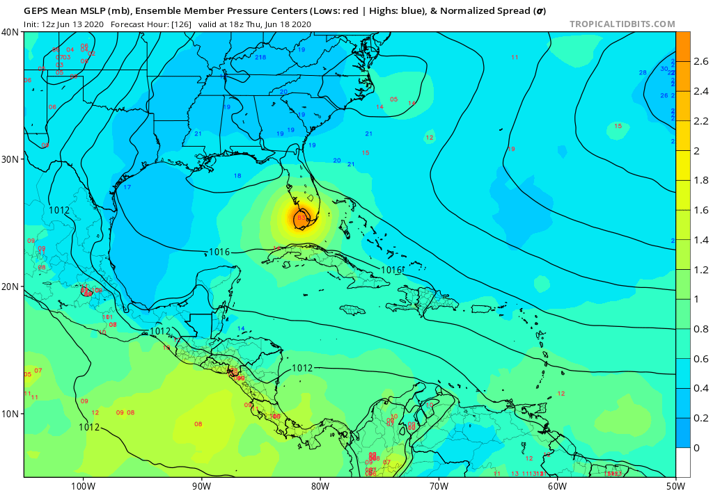
Well would you look at that, there is still one little thing hitting Florida.
2 likes
-
JetFuel_SE
- Category 1
- Posts: 288
- Age: 26
- Joined: Thu Apr 30, 2020 3:57 pm
Re: SW Caribbean Watch
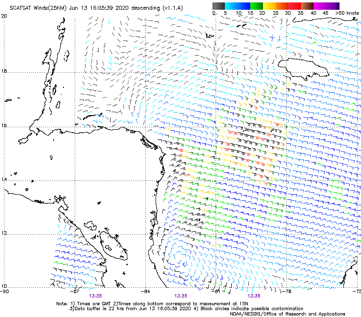
I'm unsure about the reliability of SCATSAT, but here it is, looks better than a RapidSCAT pass over Colin:
1 likes
-
Aric Dunn
- Category 5
- Posts: 21238
- Age: 43
- Joined: Sun Sep 19, 2004 9:58 pm
- Location: Ready for the Chase.
- Contact:
Re: SW Caribbean Watch
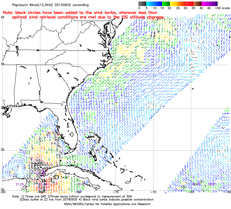
JetFuel_SE wrote:https://i.gyazo.com/8aa706fd6ec70f48fd7edd0129ff8d74.png
I'm unsure about the reliability of SCATSAT, but here it is, looks better than a RapidSCAT pass over Colin:
https://manati.star.nesdis.noaa.gov/rscat_images/arch12_low/RS2016157/zooms/WMBas19.png
I mean ASCAT is showing very similar as well as surface obs.
Deep convection continues to build around the center..
we should get a mnetion from the NHC tonight.
0 likes
Note: If I make a post that is brief. Please refer back to previous posts for the analysis or reasoning. I do not re-write/qoute what my initial post said each time.
If there is nothing before... then just ask
Space & Atmospheric Physicist, Embry-Riddle Aeronautical University,
I believe the sky is falling...
If there is nothing before... then just ask
Space & Atmospheric Physicist, Embry-Riddle Aeronautical University,
I believe the sky is falling...
-
MississippiWx

- S2K Supporter
- Posts: 1720
- Joined: Sat Aug 14, 2010 1:44 pm
- Location: Hattiesburg, Mississippi
Re: SW Caribbean Watch
This is one of those years where every disturbance tries to develop into a tropical cyclone. This probably won’t have enough water to develop on the Atlantic side, but still impressive.
3 likes
This post is not an official forecast and should not be used as such. It is just the opinion of MississippiWx and may or may not be backed by sound meteorological data. It is not endorsed by any professional institution including storm2k.org. For Official Information please refer to the NHC and NWS products.
-
Kingarabian
- S2K Supporter
- Posts: 16381
- Joined: Sat Aug 08, 2009 3:06 am
- Location: Honolulu, Hawaii
Re: SW Caribbean Watch
MississippiWx wrote:This is one of those years where every disturbance tries to develop into a tropical cyclone. This probably won’t have enough water to develop on the Atlantic side, but still impressive.
Yeah models that were keen on development tried to spin it up just NW of Panama, allowing it to track further north giving it more time over water.
0 likes
RIP Kobe Bryant

Re: SW Caribbean Watch
SSTs are high in this region, and there’s plenty of moisture in the atmosphere. The only inhibiting factor I can see is the 25-30 kt of wind shear, which, according to the 24 hr tendency map, is not changing at all.
2 likes
Irene '11 Sandy '12 Hermine '16 5/15/2018 Derecho Fay '20 Isaias '20 Elsa '21 Henri '21 Ida '21
I am only a meteorology enthusiast who knows a decent amount about tropical cyclones. Look to the professional mets, the NHC, or your local weather office for the best information.
I am only a meteorology enthusiast who knows a decent amount about tropical cyclones. Look to the professional mets, the NHC, or your local weather office for the best information.
-
Aric Dunn
- Category 5
- Posts: 21238
- Age: 43
- Joined: Sun Sep 19, 2004 9:58 pm
- Location: Ready for the Chase.
- Contact:
Re: SW Caribbean Watch
Kingarabian wrote:MississippiWx wrote:This is one of those years where every disturbance tries to develop into a tropical cyclone. This probably won’t have enough water to develop on the Atlantic side, but still impressive.
Yeah models that were keen on development tried to spin it up just NW of Panama, allowing it to track further north giving it more time over water.
majority off all the runs of GFS and ensembles showed it lifting NNW. the SW shear will keep it lopsided which would keep from going inland or crossover. possibly move across the eastern portion of Honduras.
1 likes
Note: If I make a post that is brief. Please refer back to previous posts for the analysis or reasoning. I do not re-write/qoute what my initial post said each time.
If there is nothing before... then just ask
Space & Atmospheric Physicist, Embry-Riddle Aeronautical University,
I believe the sky is falling...
If there is nothing before... then just ask
Space & Atmospheric Physicist, Embry-Riddle Aeronautical University,
I believe the sky is falling...
-
Kingarabian
- S2K Supporter
- Posts: 16381
- Joined: Sat Aug 08, 2009 3:06 am
- Location: Honolulu, Hawaii
Re: SW Caribbean Watch
Aric Dunn wrote:Kingarabian wrote:MississippiWx wrote:This is one of those years where every disturbance tries to develop into a tropical cyclone. This probably won’t have enough water to develop on the Atlantic side, but still impressive.
Yeah models that were keen on development tried to spin it up just NW of Panama, allowing it to track further north giving it more time over water.
majority off all the runs of GFS and ensembles showed it lifting NNW. the SW shear will keep it lopsided which would keep from going inland or crossover. possibly move across the eastern portion of Honduras.
Tropicaltidbts doesn't have the ICON 850mb vort graphics but the 500mb graphic shows this lifting north:

1 likes
RIP Kobe Bryant
-
SFLcane

- S2K Supporter
- Posts: 10281
- Age: 48
- Joined: Sat Jun 05, 2010 1:44 pm
- Location: Lake Worth Florida
Re: SW Caribbean Watch
Aric Dunn wrote:Kingarabian wrote:MississippiWx wrote:This is one of those years where every disturbance tries to develop into a tropical cyclone. This probably won’t have enough water to develop on the Atlantic side, but still impressive.
Yeah models that were keen on development tried to spin it up just NW of Panama, allowing it to track further north giving it more time over water.
majority off all the runs of GFS and ensembles showed it lifting NNW. the SW shear will keep it lopsided which would keep from going inland or crossover. possibly move across the eastern portion of Honduras.
Maybe a week ago... Euro brings this inland tonight.
0 likes
-
Aric Dunn
- Category 5
- Posts: 21238
- Age: 43
- Joined: Sun Sep 19, 2004 9:58 pm
- Location: Ready for the Chase.
- Contact:
Re: SW Caribbean Watch
SFLcane wrote:Aric Dunn wrote:Kingarabian wrote:Yeah models that were keen on development tried to spin it up just NW of Panama, allowing it to track further north giving it more time over water.
majority off all the runs of GFS and ensembles showed it lifting NNW. the SW shear will keep it lopsided which would keep from going inland or crossover. possibly move across the eastern portion of Honduras.
Maybe a week ago... Euro brings this inland tonight.
yeah as a shallow far weaker trough.. this would be steered mid level flow in it's present orginizartion. also as I mentioned it will be lopsided from the SW shear.
we all no how that plays out 99 percent of the time.
0 likes
Note: If I make a post that is brief. Please refer back to previous posts for the analysis or reasoning. I do not re-write/qoute what my initial post said each time.
If there is nothing before... then just ask
Space & Atmospheric Physicist, Embry-Riddle Aeronautical University,
I believe the sky is falling...
If there is nothing before... then just ask
Space & Atmospheric Physicist, Embry-Riddle Aeronautical University,
I believe the sky is falling...
-
toad strangler

- S2K Supporter
- Posts: 4546
- Joined: Sun Jul 28, 2013 3:09 pm
- Location: Earth
- Contact:
Re: SW Caribbean Watch
SFLcane wrote:Aric Dunn wrote:Kingarabian wrote:Yeah models that were keen on development tried to spin it up just NW of Panama, allowing it to track further north giving it more time over water.
majority off all the runs of GFS and ensembles showed it lifting NNW. the SW shear will keep it lopsided which would keep from going inland or crossover. possibly move across the eastern portion of Honduras.
Maybe a week ago... Euro brings this inland tonight.
yeah ... the Euro makes quick work of this. SO does the GFS
0 likes
My Weather Station
https://www.wunderground.com/dashboard/pws/KFLPORTS603
https://www.wunderground.com/dashboard/pws/KFLPORTS603
-
Kingarabian
- S2K Supporter
- Posts: 16381
- Joined: Sat Aug 08, 2009 3:06 am
- Location: Honolulu, Hawaii
Re: SW Caribbean Watch
toad strangler wrote:SFLcane wrote:Aric Dunn wrote:
majority off all the runs of GFS and ensembles showed it lifting NNW. the SW shear will keep it lopsided which would keep from going inland or crossover. possibly move across the eastern portion of Honduras.
Maybe a week ago... Euro brings this inland tonight.
yeah ... the Euro makes quick work of this. SO does the GFS
Not sure if its the same disturbance but the 18z GFS has it over water compared to previous runs.

Not much to see @ 850mb.
1 likes
RIP Kobe Bryant
-
Aric Dunn
- Category 5
- Posts: 21238
- Age: 43
- Joined: Sun Sep 19, 2004 9:58 pm
- Location: Ready for the Chase.
- Contact:
Re: SW Caribbean Watch
Kingarabian wrote:Aric Dunn wrote:Kingarabian wrote:Yeah models that were keen on development tried to spin it up just NW of Panama, allowing it to track further north giving it more time over water.
majority off all the runs of GFS and ensembles showed it lifting NNW. the SW shear will keep it lopsided which would keep from going inland or crossover. possibly move across the eastern portion of Honduras.
Tropicaltidbts doesn't have the ICON 850mb vort graphics but the 500mb graphic shows this lifting north:
https://i.imgur.com/jtBuGSF.png
yeah, it would almost certainly move north or nnw with the mid level flow
and clearly the models are not initializing the surface and low levels correctly. since we have surface and ASCAT data indicating much more going on than the models are showing.
2 likes
Note: If I make a post that is brief. Please refer back to previous posts for the analysis or reasoning. I do not re-write/qoute what my initial post said each time.
If there is nothing before... then just ask
Space & Atmospheric Physicist, Embry-Riddle Aeronautical University,
I believe the sky is falling...
If there is nothing before... then just ask
Space & Atmospheric Physicist, Embry-Riddle Aeronautical University,
I believe the sky is falling...
-
wxman57

- Moderator-Pro Met

- Posts: 23175
- Age: 68
- Joined: Sat Jun 21, 2003 8:06 pm
- Location: Houston, TX (southwest)
Re: SW Caribbean Watch
Looks like it'll move inland into CA by tomorrow. Close to zero chance of development. Very high shear there, too. Might get something in the East Pac over the next week or two, but the Atlantic looks quiet.
4 likes
Who is online
Users browsing this forum: No registered users and 153 guests