Bay of Campeche: (Invest 93L is up)

This is the general tropical discussion area. Anyone can take their shot at predicting a storms path.

Moderator: S2k Moderators

Forum rules

The posts in this forum are NOT official forecasts and should not be used as such. They are just the opinion of the poster and may or may not be backed by sound meteorological data. They are NOT endorsed by any professional institution or STORM2K. For official information, please refer to products from the National Hurricane Center and National Weather Service.

Help Support Storm2K
Message
Author
Aric Dunn
Category 5
Category 5
Posts: 21238
Age: 42
Joined: Sun Sep 19, 2004 9:58 pm
Location: Ready for the Chase.
Contact:

Re: Bay of Campeche

#21 Postby Aric Dunn » Sat May 30, 2020 2:55 pm

I think the euro and 90 percent of the ensembles have lached onto this cyclonic loop being brought on by the BOC distrubance..

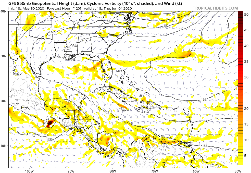
after it gets into the BOC there is a lot of uncertianity. does it stay over water, ridging etc..

Image
1 likes   
Note: If I make a post that is brief. Please refer back to previous posts for the analysis or reasoning. I do not re-write/qoute what my initial post said each time.
If there is nothing before... then just ask :)

Space & Atmospheric Physicist, Embry-Riddle Aeronautical University,
I believe the sky is falling...

stormlover2013

Re: Bay of Campeche

#22 Postby stormlover2013 » Sat May 30, 2020 3:02 pm

0 likes   

User avatar
KatDaddy
Category 5
Category 5
Posts: 2815
Joined: Mon Oct 21, 2002 6:23 pm
Location: League City, Texas

Re: Bay of Campeche

#23 Postby KatDaddy » Sat May 30, 2020 3:12 pm

Yep, I will be watching closely over here along the Upper TX Coast. Hopefully only some tropical moisture but this is crazy 2020. :eek: :lol: :roll: :( :grrr: :wink:
3 likes   
The following post is NOT an official forecast and should not be used as such. It is just the opinion of the poster and may or may not be backed by sound meteorological data. It is NOT endorsed by any professional institution including storm2k.org For Official Information please refer to the NHC and NWS products.

User avatar
aspen
Category 5
Category 5
Posts: 8818
Joined: Sat Oct 12, 2019 7:10 pm
Location: Connecticut, USA

Re: Bay of Campeche

#24 Postby aspen » Sat May 30, 2020 3:15 pm

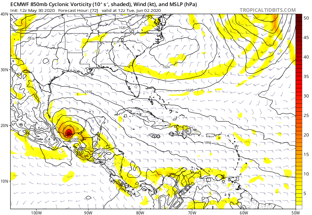
stormlover2013 wrote:https://weather.us/cyclone-tracks/euro/921-w-267-n/2020053012-240.html

Those are a lot of ensemble members showing a strong TS to a Cat 2 hurricane.
1 likes   
Irene '11 Sandy '12 Hermine '16 5/15/2018 Derecho Fay '20 Isaias '20 Elsa '21 Henri '21 Ida '21

I am only a meteorology enthusiast who knows a decent amount about tropical cyclones. Look to the professional mets, the NHC, or your local weather office for the best information.

Aric Dunn
Category 5
Category 5
Posts: 21238
Age: 42
Joined: Sun Sep 19, 2004 9:58 pm
Location: Ready for the Chase.
Contact:

Re: Bay of Campeche

#25 Postby Aric Dunn » Sat May 30, 2020 3:15 pm

and here is why the sudden consensus of the euro and ensembles showing a large cyclonic loop.

there is vorticity over the southern BOC and mexico. TD1E will be forced NNE to NE then bend back WNW as that vorticity drops SW and weakens over the mountains..

Image
1 likes   
Note: If I make a post that is brief. Please refer back to previous posts for the analysis or reasoning. I do not re-write/qoute what my initial post said each time.
If there is nothing before... then just ask :)

Space & Atmospheric Physicist, Embry-Riddle Aeronautical University,
I believe the sky is falling...

User avatar
Dylan
Professional-Met
Professional-Met
Posts: 338
Age: 30
Joined: Mon May 31, 2010 9:50 am
Location: New Orleans, LA

Re: Bay of Campeche

#26 Postby Dylan » Sat May 30, 2020 3:34 pm

1 likes   
Georges('98), Allison('01), Isidore('02), Lili('02), Frances('04) Ivan('04), Cindy('05), Katrina('05), Rita('05), Gustav('08), Isaac('12), Matthew('16), Harvey('17), Irma('17), Nate ('17), Ida ('21).

User avatar
aspen
Category 5
Category 5
Posts: 8818
Joined: Sat Oct 12, 2019 7:10 pm
Location: Connecticut, USA

Re: Bay of Campeche

#27 Postby aspen » Sat May 30, 2020 4:10 pm

Aric Dunn wrote:and here is why the sudden consensus of the euro and ensembles showing a large cyclonic loop.

there is vorticity over the southern BOC and mexico. TD1E will be forced NNE to NE then bend back WNW as that vorticity drops SW and weakens over the mountains..

https://i.ibb.co/Vqq08Tm/Capture.png

If the other low weakens quicker, would TD2/its remnants continue on its NNE/NE trajectory, or would it still be pulled WNW?
0 likes   
Irene '11 Sandy '12 Hermine '16 5/15/2018 Derecho Fay '20 Isaias '20 Elsa '21 Henri '21 Ida '21

I am only a meteorology enthusiast who knows a decent amount about tropical cyclones. Look to the professional mets, the NHC, or your local weather office for the best information.

User avatar
cycloneye
Admin
Admin
Posts: 145307
Age: 68
Joined: Thu Oct 10, 2002 10:54 am
Location: San Juan, Puerto Rico

Re: Bay of Campeche

#28 Postby cycloneye » Sat May 30, 2020 4:48 pm

1 likes   
Visit the Caribbean-Central America Weather Thread where you can find at first post web cams,radars
and observations from Caribbean basin members Click Here

Aric Dunn
Category 5
Category 5
Posts: 21238
Age: 42
Joined: Sun Sep 19, 2004 9:58 pm
Location: Ready for the Chase.
Contact:

Re: Bay of Campeche

#29 Postby Aric Dunn » Sat May 30, 2020 5:01 pm

TD2e sure is trying to deepen quickly.. any improvement to the 850mb vorticity now will help it redevelop on the flip side later.. either in the NW carrib or BOC>
1 likes   
Note: If I make a post that is brief. Please refer back to previous posts for the analysis or reasoning. I do not re-write/qoute what my initial post said each time.
If there is nothing before... then just ask :)

Space & Atmospheric Physicist, Embry-Riddle Aeronautical University,
I believe the sky is falling...

User avatar
cycloneye
Admin
Admin
Posts: 145307
Age: 68
Joined: Thu Oct 10, 2002 10:54 am
Location: San Juan, Puerto Rico

Re: Bay of Campeche

#30 Postby cycloneye » Sat May 30, 2020 7:20 pm

A broad area of disturbed weather is expected to stretch across
portions of southern Mexico and the southwestern Gulf of Mexico for
the next several days. An area of low pressure could form in this
region by the middle of next week, and some gradual development is
possible thereafter if the system remains over water. Regardless of
development, heavy rainfall is likely over portions of southern
Mexico during the next few days. The next Special Tropical Weather
Outlook will be issued by 9 AM EDT Sunday, or earlier if necessary.
* Formation chance through 48 hours...low...near 0 percent.
* Formation chance through 5 days...low...20 percent.


Image
2 likes   
Visit the Caribbean-Central America Weather Thread where you can find at first post web cams,radars
and observations from Caribbean basin members Click Here

User avatar
gatorcane
S2K Supporter
S2K Supporter
Posts: 23691
Age: 47
Joined: Sun Mar 13, 2005 3:54 pm
Location: Boca Raton, FL

Re: Bay of Campeche: 8 PM STWO=20% in 5 days

#31 Postby gatorcane » Sat May 30, 2020 7:46 pm

The GFS has nada there in 5 days, on EPAC side instead:

Image

On the other hand the Euro has something in just a few days:

Image

But wait aren’t what the the GFS and Euro showing within 5 days the EPAC system? Any broad low that forms is beyond 5 days in the models and hence would not warrant a mention by NHC at this time separate from discussion under the EPAC system.
0 likes   

User avatar
cycloneye
Admin
Admin
Posts: 145307
Age: 68
Joined: Thu Oct 10, 2002 10:54 am
Location: San Juan, Puerto Rico

Re: Bay of Campeche: 8 PM STWO=20% in 5 days

#32 Postby cycloneye » Sat May 30, 2020 7:57 pm

Great thread from Philippe Papin.

 https://twitter.com/pppapin/status/1266894618500542464


0 likes   
Visit the Caribbean-Central America Weather Thread where you can find at first post web cams,radars
and observations from Caribbean basin members Click Here

User avatar
Nancy Smar
Category 5
Category 5
Posts: 1081
Age: 24
Joined: Wed Aug 16, 2017 10:03 pm

Re: Bay of Campeche: 8 PM STWO=20% in 5 days

#33 Postby Nancy Smar » Sat May 30, 2020 8:09 pm

GENESIS004, AL, L, , , , , 74, 2020, DB, O, 2020053100, 9999999999, , 004, , , , GENESIS, , AL742020
0 likes   

User avatar
cycloneye
Admin
Admin
Posts: 145307
Age: 68
Joined: Thu Oct 10, 2002 10:54 am
Location: San Juan, Puerto Rico

Re: Bay of Campeche: 8 PM STWO=20% in 5 days

#34 Postby cycloneye » Sat May 30, 2020 8:17 pm

Nancy Smar wrote:
GENESIS004, AL, L, , , , , 74, 2020, DB, O, 2020053100, 9999999999, , 004, , , , GENESIS, , AL742020


Is that a test?
1 likes   
Visit the Caribbean-Central America Weather Thread where you can find at first post web cams,radars
and observations from Caribbean basin members Click Here

User avatar
Nancy Smar
Category 5
Category 5
Posts: 1081
Age: 24
Joined: Wed Aug 16, 2017 10:03 pm

Re: Bay of Campeche: 8 PM STWO=20% in 5 days

#35 Postby Nancy Smar » Sat May 30, 2020 8:45 pm

cycloneye wrote:
Nancy Smar wrote:
GENESIS004, AL, L, , , , , 74, 2020, DB, O, 2020053100, 9999999999, , 004, , , , GENESIS, , AL742020


Is that a test?

No. They call it a pre-invest/genesis.
In fact, pre-invests/genesises are identified by their (both NHC and JTWC) temporary number of 71-79.
4 likes   

stormlover2013

Re: Bay of Campeche

#36 Postby stormlover2013 » Sat May 30, 2020 10:51 pm

1 likes   

User avatar
StruThiO
Category 3
Category 3
Posts: 821
Age: 25
Joined: Fri Sep 15, 2017 5:51 am
Location: Currently Portland, OR. Raised in Jax, FL.

Re: Bay of Campeche

#37 Postby StruThiO » Sun May 31, 2020 1:28 am

Special Tropical Weather Outlook
NWS National Hurricane Center Miami FL
200 AM EDT Sun May 31 2020

For the North Atlantic...Caribbean Sea and the Gulf of Mexico:

Tropical Depression Two-E, located near the Pacific coasts of
Guatemala and El Salvador, is forecast to move inland and dissipate
over Guatemala or southeastern Mexico by tonight. However, the
remnants are expected to turn northwestward within a broader
developing area of disturbed weather, possibly emerging over the
Bay of Campeche on Monday. If the remnants do move back over
water, environmental conditions appear conducive to support some
redevelopment of the system while it moves little during much of
the upcoming week. Regardless of redevelopment, heavy rainfall is
likely over portions of southern Mexico during the next few days.
The next Special Tropical Weather Outlook will be issued later
this morning by 9 AM EDT.
* Formation chance through 48 hours...low...10 percent.
* Formation chance through 5 days...low...30 percent.


Image
0 likes   

User avatar
GCANE
S2K Supporter
S2K Supporter
Posts: 11496
Joined: Mon Oct 22, 2007 8:03 am

EPAC: AMANDA - Models

#38 Postby GCANE » Sun May 31, 2020 7:01 am

The setup in the GOM, IMHO, looks good.
The only thing I seeing missing, that could make this a major, is the setup for an outflow channel.
1 likes   

User avatar
NDG
S2K Supporter
S2K Supporter
Posts: 15446
Joined: Sun Jul 09, 2006 10:14 pm
Location: Orlando, FL

Re: Bay of Campeche

#39 Postby NDG » Sun May 31, 2020 7:33 am

Up to 40/50.

Image
1 likes   

User avatar
cycloneye
Admin
Admin
Posts: 145307
Age: 68
Joined: Thu Oct 10, 2002 10:54 am
Location: San Juan, Puerto Rico

Re: Bay of Campeche

#40 Postby cycloneye » Sun May 31, 2020 7:36 am

Special Tropical Weather Outlook
NWS National Hurricane Center Miami FL
805 AM EDT Sun May 31 2020

For the North Atlantic...Caribbean Sea and the Gulf of Mexico:

Special Tropical Weather Outlook issued to discuss the potential for
tropical cyclone formation over the southwestern Gulf of Mexico.

Eastern Pacific Tropical Storm Amanda, centered inland over
southeastern Guatemala, is forecast weaken into a remnant low or
dissipate over Guatemala or southeastern Mexico by tonight.
However, the remnants of Amanda are expected to move northwestward
within a broader area of disturbed weather, possibly emerging over
the southeastern Bay of Campeche on Monday. If the remnants move
back over water, environmental conditions appear conducive to
support some redevelopment of the system while it moves little
through the middle of this week. Regardless of redevelopment, heavy
rainfall is likely to continue over portions of southern Mexico
during the next few days. For additional information on the
rainfall threat, see products from your national meteorological
service. The next Special Tropical Weather Outlook will be by 3 PM
EDT today, or earlier if necessary.
* Formation chance through 48 hours...medium...40 percent.
* Formation chance through 5 days...medium...50 percent.

$$
Forecaster Brown/Brennan
0 likes   
Visit the Caribbean-Central America Weather Thread where you can find at first post web cams,radars
and observations from Caribbean basin members Click Here


Return to “Talkin' Tropics”

Who is online

Users browsing this forum: BobHarlem, KeysRedWine, NotSparta, TomballEd and 51 guests