Texas Spring 2020

U.S. & Caribbean Weather Discussions and Severe Weather Events

Moderator: S2k Moderators

Forum rules

The posts in this forum are NOT official forecast and should not be used as such. They are just the opinion of the poster and may or may not be backed by sound meteorological data. They are NOT endorsed by any professional institution or STORM2K.

Help Support Storm2K
Message
Author
User avatar
South Texas Storms
Professional-Met
Professional-Met
Posts: 4226
Joined: Thu Jun 24, 2010 12:28 am
Location: Houston, TX

Re: Texas Spring 2020

#561 Postby South Texas Storms » Wed Apr 29, 2020 6:42 am

Haris wrote:[url]https://i.ibb.co/CHpQJyb/C5-BFE6-B0-411-C-48-FC-B77-F-EE1-B67-F3-BE9-A.gif [/url]

It is a major over performer here!!

What a change of luck!! :D


Lucky! Storms going poof as they reach SA...typical :cry:
0 likes   

weatherdude1108
Category 5
Category 5
Posts: 4228
Joined: Tue Dec 13, 2011 1:04 pm
Location: Northwest Austin/Cedar Park, TX

Re: Texas Spring 2020

#562 Postby weatherdude1108 » Wed Apr 29, 2020 7:20 am

South Texas Storms wrote:
Haris wrote:[url]https://i.ibb.co/CHpQJyb/C5-BFE6-B0-411-C-48-FC-B77-F-EE1-B67-F3-BE9-A.gif [/url]

It is a major over performer here!!

What a change of luck!! :D


Lucky! Storms going poof as they reach SA...typical :cry:


That sucks. They were under a Significant Weather Advisory, which just expired at 7:15. I was hoping it would tap into the instability there. Looks like they got the outflow boundary from the Austin storms. Was hoping my dad and brothers in SA could share wet news. Man.

:cry: :roll:
1 likes   
The preceding post is NOT an official forecast, and should not be used as such. It is only the opinion of the poster and may or may not be backed by sound meteorological data. It is NOT endorsed by any professional institution including storm2k.org. For Official Information please refer to the NHC and NWS products.

User avatar
Cpv17
Category 5
Category 5
Posts: 4979
Joined: Wed Dec 07, 2016 2:24 pm
Location: Wharton/El Campo, TX

Re: Texas Spring 2020

#563 Postby Cpv17 » Wed Apr 29, 2020 7:20 am

Closing in on 5” here in central Wharton County this morning. Biggest rain of the year.
2 likes   

weatherdude1108
Category 5
Category 5
Posts: 4228
Joined: Tue Dec 13, 2011 1:04 pm
Location: Northwest Austin/Cedar Park, TX

Re: Texas Spring 2020

#564 Postby weatherdude1108 » Wed Apr 29, 2020 8:47 am

I didn't get nearly what Cpv17 got, but mine registered between 0.5" and 0.75" early this morning with the heavy thunderstorms that moved through. Nice.

Looks like "July" for the next several days. Ugh.
1 likes   
The preceding post is NOT an official forecast, and should not be used as such. It is only the opinion of the poster and may or may not be backed by sound meteorological data. It is NOT endorsed by any professional institution including storm2k.org. For Official Information please refer to the NHC and NWS products.

User avatar
CaptinCrunch
S2K Supporter
S2K Supporter
Posts: 8728
Age: 57
Joined: Mon Nov 03, 2003 4:33 pm
Location: Kennedale, TX (Tarrant Co.)

Re: Texas Spring 2020

#565 Postby CaptinCrunch » Wed Apr 29, 2020 11:54 am

Ntxw wrote:
Brent wrote:Not nearly as much wind as I expected given the radar presentation

I was downstairs watching out on the patio and kept waiting for more


58mph gust at DFW airport. Pretty standard line, albeit broken on the western end. Nothing too extraordinary. Not much lightning or thunder at the airport to report, brief downpour.


Correct on that, the storm Tuesday morning @ my house was by far more intense than anything I saw last night. I excaped both rounds with no hail, not much wind, and just moderate rainfall.
0 likes   

Brent
S2K Supporter
S2K Supporter
Posts: 38090
Age: 36
Joined: Sun May 16, 2004 10:30 pm
Location: Tulsa Oklahoma
Contact:

Re: Texas Spring 2020

#566 Postby Brent » Wed Apr 29, 2020 1:32 pm

Guys I think there's more wind now than there was last night :lol: :lol: :lol:
4 likes   
#neversummer

User avatar
wxman22
Category 5
Category 5
Posts: 1492
Joined: Mon Jan 30, 2006 12:39 am
Location: Wichita Falls, TX
Contact:

Re: Texas Spring 2020

#567 Postby wxman22 » Wed Apr 29, 2020 3:11 pm

I would say at least the Enhanced risk was warranted.

Image
1 likes   

User avatar
Haris
Category 5
Category 5
Posts: 1810
Joined: Mon Nov 27, 2017 8:19 pm
Location: ( Bee Cave) West Austin, Texas

Re: Texas Spring 2020

#568 Postby Haris » Wed Apr 29, 2020 6:24 pm

1” on the dot this morning. Pushing over 4” this month.
3 likes   
Weather geek and a storm spotter in West Austin. Not a degreed meteorologist. Big snow fan. Love rain and cold! Despise heat!

weatherdude1108
Category 5
Category 5
Posts: 4228
Joined: Tue Dec 13, 2011 1:04 pm
Location: Northwest Austin/Cedar Park, TX

Re: Texas Spring 2020

#569 Postby weatherdude1108 » Thu Apr 30, 2020 4:21 pm

Going from April straight to July. :roll: :hmm:

Area Forecast Discussion
National Weather Service Austin/San Antonio TX
242 PM CDT Thu Apr 30 2020

.SHORT TERM (Tonight through Friday Night)...
Clear skies and mild overnight low temperatures can be expected
across south central Texas tonight. With weak high pressure over
east Texas, our surface winds will become southerly across most
areas. Lows will be pretty close to climatological normals, with
temperatures ranging from the mid 50s to the mid 60s.

Gusty south winds will signal a warming trend tomorrow. Shallow
moisture in the low-levels will mix out and with plenty of sunshine,
we should see highs in the upper 80s to mid 90s.

&&

.LONG TERM (Saturday through Thursday)...
The beginning of May will feel more like the beginning of July. An
upper level ridge will move across the Southern Plains over the
weekend and early next week while surface high pressure settles over
the Gulf. The low level flow will be from the southeast keeping warm,
moist air over South Central Texas. Temperatures will warm slowly
during this timeframe. High temperatures Saturday will be in the 90s
most places with the upper 90s along the Rio Grande. They will
increase slightly each day until Tuesday when most places will be
middle to upper 90s with triple digits from San Antonio to Del Rio
and southward. Wednesday a cold front will bring relief from the
heat, but probably no rain. There is some model disagreement on
whether this front will produce any precipitation with the GFS being
wetter than the ECMWF. The blended guidance is dry and we have used
that for now.
There will be cooler air behind this boundary and highs
Wednesday will be 10 to 15 degrees cooler than Tuesday.
0 likes   
The preceding post is NOT an official forecast, and should not be used as such. It is only the opinion of the poster and may or may not be backed by sound meteorological data. It is NOT endorsed by any professional institution including storm2k.org. For Official Information please refer to the NHC and NWS products.

Brent
S2K Supporter
S2K Supporter
Posts: 38090
Age: 36
Joined: Sun May 16, 2004 10:30 pm
Location: Tulsa Oklahoma
Contact:

Re: Texas Spring 2020

#570 Postby Brent » Thu Apr 30, 2020 5:30 pm

first time in awhile there's zero rain chances :double:

Sunday/Monday is definitely gonna resemble July
0 likes   
#neversummer

User avatar
Cpv17
Category 5
Category 5
Posts: 4979
Joined: Wed Dec 07, 2016 2:24 pm
Location: Wharton/El Campo, TX

Re: Texas Spring 2020

#571 Postby Cpv17 » Thu Apr 30, 2020 6:48 pm

Big differences in the models right now between the Euro and GFS.
0 likes   

lukem
Tropical Storm
Tropical Storm
Posts: 123
Joined: Wed Feb 17, 2010 2:53 pm

Re: Texas Spring 2020

#572 Postby lukem » Thu Apr 30, 2020 8:12 pm

Cpv17 wrote:Big differences in the models right now between the Euro and GFS.

What’s the Euro showing? Looks like the GFS is showing decent rain for much if the state.
0 likes   

User avatar
Cpv17
Category 5
Category 5
Posts: 4979
Joined: Wed Dec 07, 2016 2:24 pm
Location: Wharton/El Campo, TX

Re: Texas Spring 2020

#573 Postby Cpv17 » Thu Apr 30, 2020 8:17 pm

lukem wrote:
Cpv17 wrote:Big differences in the models right now between the Euro and GFS.

What’s the Euro showing? Looks like the GFS is showing decent rain for much if the state.


The Euro is a lot drier.
0 likes   

Brent
S2K Supporter
S2K Supporter
Posts: 38090
Age: 36
Joined: Sun May 16, 2004 10:30 pm
Location: Tulsa Oklahoma
Contact:

Re: Texas Spring 2020

#574 Postby Brent » Fri May 01, 2020 12:45 am

for those not wanting summer... the GFS has the weekend of the 9th-10th extremely cold vs what happens the next few days :lol: :lol: DFW is pretty much below 60 both days. Saturday afternoon it's barely 50 :lol: :lol: :lol: this would verbatim threaten record low maximums :spam: (for the record the coldest May high for Dallas is 49) :lol:

Image
2 likes   
#neversummer

User avatar
Cpv17
Category 5
Category 5
Posts: 4979
Joined: Wed Dec 07, 2016 2:24 pm
Location: Wharton/El Campo, TX

Re: Texas Spring 2020

#575 Postby Cpv17 » Fri May 01, 2020 2:30 am

Brent wrote:for those not wanting summer... the GFS has the weekend of the 9th-10th extremely cold vs what happens the next few days :lol: :lol: DFW is pretty much below 60 both days. Saturday afternoon it's barely 50 :lol: :lol: :lol: this would verbatim threaten record low maximums :spam: (for the record the coldest May high for Dallas is 49) :lol:

https://i.ibb.co/nzLSwgB/gfs-T2ma-scus-40.png


The 0z Euro has it now too along with a whole bunch of rain. Has a spot just a few miles north of Boerne with nearly 12”.
2 likes   

User avatar
EnnisTx
S2K Supporter
S2K Supporter
Posts: 896
Joined: Sat Dec 26, 2015 4:06 pm
Location: Albany, Texas
Contact:

Re: Texas Spring 2020

#576 Postby EnnisTx » Fri May 01, 2020 1:36 pm

Brent wrote:for those not wanting summer... the GFS has the weekend of the 9th-10th extremely cold vs what happens the next few days :lol: :lol: DFW is pretty much below 60 both days. Saturday afternoon it's barely 50 :lol: :lol: :lol: this would verbatim threaten record low maximums :spam: (for the record the coldest May high for Dallas is 49) :lol:

https://i.ibb.co/nzLSwgB/gfs-T2ma-scus-40.png


I'll take that all Summer long.
2 likes   

User avatar
captainbarbossa19
Professional-Met
Professional-Met
Posts: 1092
Age: 27
Joined: Wed Aug 21, 2019 11:09 pm
Location: Beaumont, TX

Re: Texas Spring 2020

#577 Postby captainbarbossa19 » Fri May 01, 2020 2:35 pm

Cpv17 wrote:
Brent wrote:for those not wanting summer... the GFS has the weekend of the 9th-10th extremely cold vs what happens the next few days :lol: :lol: DFW is pretty much below 60 both days. Saturday afternoon it's barely 50 :lol: :lol: :lol: this would verbatim threaten record low maximums :spam: (for the record the coldest May high for Dallas is 49) :lol:

https://i.ibb.co/nzLSwgB/gfs-T2ma-scus-40.png


The 0z Euro has it now too along with a whole bunch of rain. Has a spot just a few miles north of Boerne with nearly 12”.

Right now, I really have little confidence in anything the models are projecting. On Tuesday, short-term models did not show any precipitation arriving until the line of storms after midnight on Wednesday. However, many thunderstorms developed around noon on Tuesday east of Houston, and many areas received 3 inches of rain or more before the line arrived. While this was a short-term model error, even the mid-range and long-range models have not been doing so well as of late. Small changes in weather patterns can certainly have large-scale effects in the models. I think that this is part of the problem, but as I said before, I think the algorithms used in the past were better for several models than what is currently in use.

On a slightly different note, I do think that at least the SE TX region is beginning to return to a more normal/slightly wetter than normal pattern. In March, I barely recorded half an inch for the whole month. However in April, I recorded about 4 inches of rain and it was spread out over the whole month. While this may not be a good indicator of what is to come, I do believe that the pattern is now not nearly as dry as it was. This is just my opinion though. :)
2 likes   

weatherdude1108
Category 5
Category 5
Posts: 4228
Joined: Tue Dec 13, 2011 1:04 pm
Location: Northwest Austin/Cedar Park, TX

Re: Texas Spring 2020

#578 Postby weatherdude1108 » Fri May 01, 2020 3:03 pm

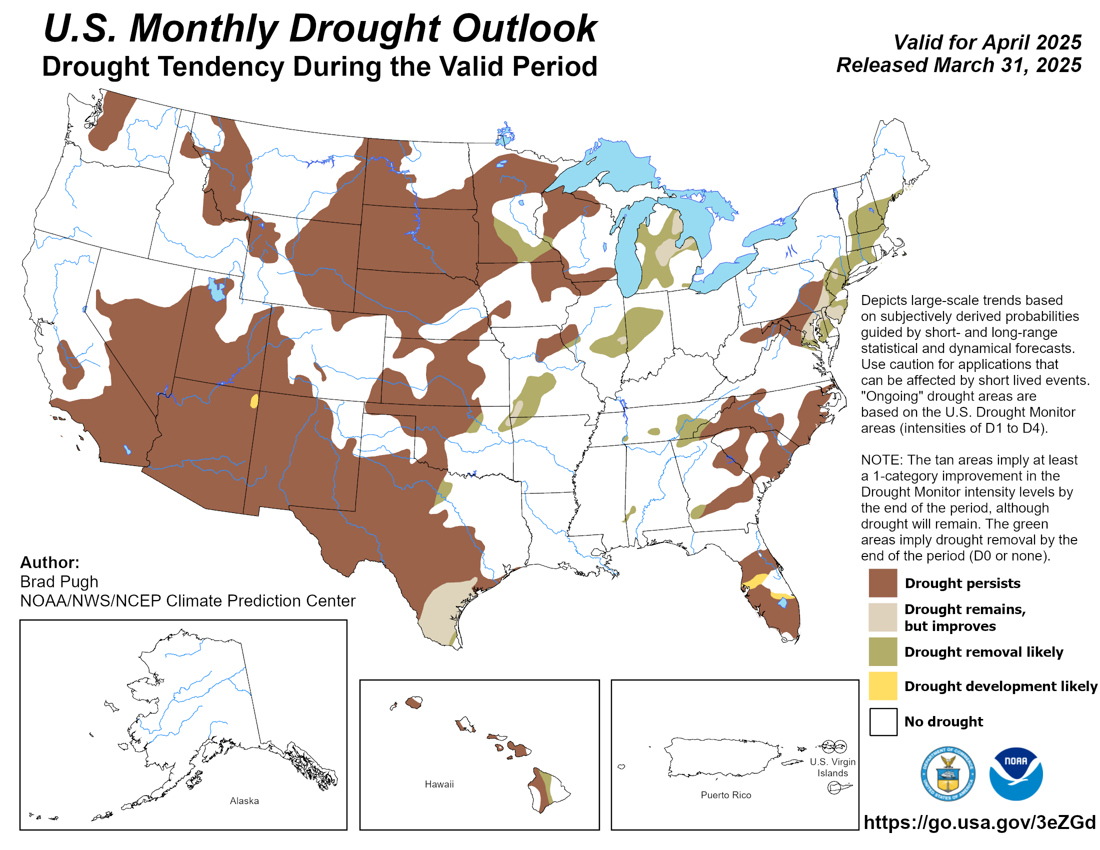
This looks more encouraging for south and southeast Texas fwiw.

Image
2 likes   
The preceding post is NOT an official forecast, and should not be used as such. It is only the opinion of the poster and may or may not be backed by sound meteorological data. It is NOT endorsed by any professional institution including storm2k.org. For Official Information please refer to the NHC and NWS products.

weatherdude1108
Category 5
Category 5
Posts: 4228
Joined: Tue Dec 13, 2011 1:04 pm
Location: Northwest Austin/Cedar Park, TX

Re: Texas Spring 2020

#579 Postby weatherdude1108 » Fri May 01, 2020 3:10 pm

1984 sticks out as record heat days for May. I remember that year as a kid and the talk of drought in the news at the time. The lower aquifer levels in San Antonio were a big story. First time I had heard of the aquifer was 1984.

000
FXUS64 KEWX 011944
AFDEWX

Area Forecast Discussion
National Weather Service Austin/San Antonio TX
244 PM CDT Fri May 1 2020

.SHORT TERM (Tonight through Saturday Night)...
A low amplitude upper level ridge will move across Texas during the
period. Surface high pressure will be centered over the central Gulf
coast and the low level flow will be southerly to southeasterly.
This will bring warm, moist air into South Central Texas. Subsident
flow will keep the weather dry through the short term. Temperatures
will continue to warm. After a couple of chilly mornings low
temperatures Saturday will be near to a few degrees above normal.
Highs Saturday will be a couple of degrees warmer than Friday. Lows
Sunday will be up a few degrees from Saturday. The pressure gradient
will tighten during the day Saturday and winds will be breezy at 10
to 15 mph with some higher gusts.

&&

.LONG TERM (Sunday through Friday)...
A warming trend is expected Sunday and Monday across South Central
Texas. By Monday and Tuesday high temperatures are forecast to be in
the mid to upper 90s for most areas, with 100-104 forecast along the
Rio Grande. We may stop a couple of degrees short of records at
Austin and San Antonio Sunday and Monday, however Del Rio`s records
may be in jeopardy (see records below). Elevated fire weather
conditions will continue through this time frame across western areas
closer to the Rio Grande, give the lower RH values, hot/dry
conditions, and gusty southerly winds.

A cold front is forecast to move into the region Tuesday night.
Isolated showers and thunderstorms are possible along the cold front
and dry line Tuesday evening across portions of the Hill Country and
Rio Grande, potentially working into and east of the I-35 corridor
overnight and Wednesday, although confidence is low. Can`t rule out
a few stronger storms Tuesday evening across western and northern
areas of the CWA given forecast soundings.

Cooler behind the front Wednesday and Thursday, with forecast high
temperatures closer to averages for this time of year. Another cold
front and low chance for storms is possible late in the forecast
period Friday.

Record High Temperatures:

May 3 May 4 May 5

Austin Bergstrom 94 (2017) 98 (1984) 101 (1984)
Austin Camp Mabry 95 (2017) 100 (1984) 100 (1984)
San Antonio 98 (1984) 99 (1984) 99 (1984)
Del Rio 101 (1964) 102 (1984) 104 (1906)
0 likes   
The preceding post is NOT an official forecast, and should not be used as such. It is only the opinion of the poster and may or may not be backed by sound meteorological data. It is NOT endorsed by any professional institution including storm2k.org. For Official Information please refer to the NHC and NWS products.

User avatar
South Texas Storms
Professional-Met
Professional-Met
Posts: 4226
Joined: Thu Jun 24, 2010 12:28 am
Location: Houston, TX

Re: Texas Spring 2020

#580 Postby South Texas Storms » Fri May 01, 2020 6:42 pm

weatherdude1108 wrote:This looks more encouraging for south and southeast Texas fwiw.

https://www.cpc.ncep.noaa.gov/products/expert_assessment/month_drought.png


Yeah it definitely looks promising that we could see a wet May. Let's hope and pray we can get some good drought denting rain events before the boring summer weather pattern kicks in.
0 likes   


Return to “USA & Caribbean Weather”

Who is online

Users browsing this forum: 869MB and 13 guests