2019 Tropics: Global Model Runs Discussion (Out to day 16)

This is the general tropical discussion area. Anyone can take their shot at predicting a storms path.

Moderator: S2k Moderators

Forum rules

The posts in this forum are NOT official forecasts and should not be used as such. They are just the opinion of the poster and may or may not be backed by sound meteorological data. They are NOT endorsed by any professional institution or STORM2K. For official information, please refer to products from the National Hurricane Center and National Weather Service.

Help Support Storm2K
Message
Author
User avatar
toad strangler
S2K Supporter
S2K Supporter
Posts: 4543
Joined: Sun Jul 28, 2013 3:09 pm
Location: Earth
Contact:

Re: 2019 Tropics: Global Model Runs Discussion (Out to day 16)

#1221 Postby toad strangler » Sun Oct 06, 2019 7:10 pm

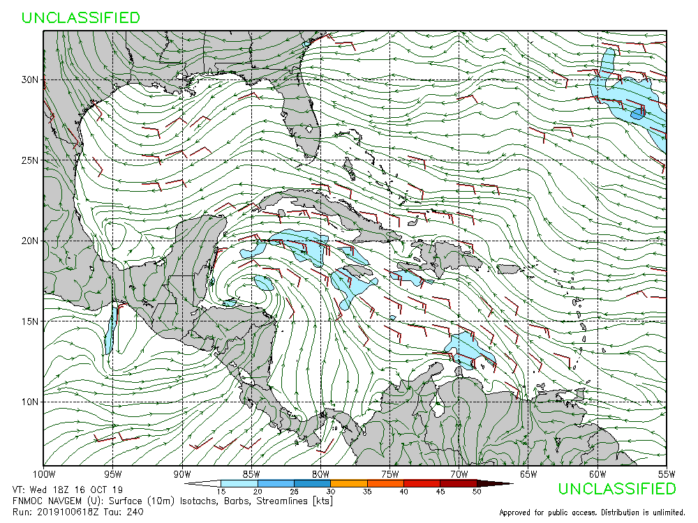
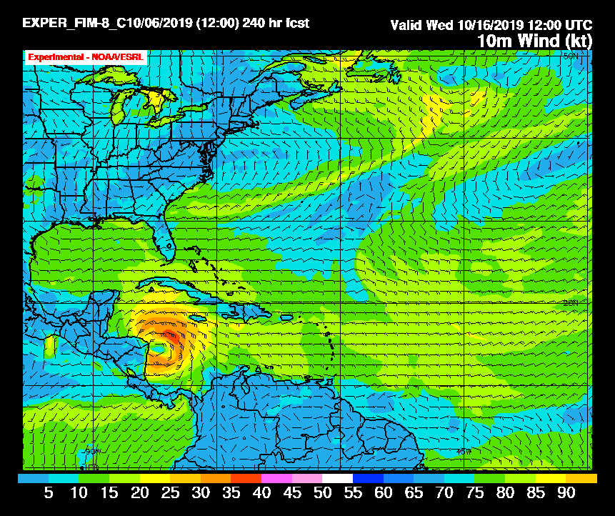
gatorcane wrote:Ut oh 18Z GFS. Ridge is much weaker allowing a path north. :eek:


500mb set ups are way too delicate to trust as a given at this range. No way was the model going to stick with one solution. Chances for a storm in the Sw or S Caribbean rise though.
0 likes   

User avatar
Ubuntwo
Category 5
Category 5
Posts: 1406
Age: 31
Joined: Thu Oct 05, 2017 10:41 pm

Re: 2019 Tropics: Global Model Runs Discussion (Out to day 16)

#1222 Postby Ubuntwo » Sun Oct 06, 2019 7:23 pm

18z GEFS similar to the 12z but with a slight uptick in intensity. Most track over or near Nicaragua then stall off the coast of the Yucatan, somewhere in the W Caribbean. After then it's anyone's game.
0 likes   
Kendall -> SLO -> PBC

Memorable Storms: Katrina (for its Florida landfall...) Wilma Matthew Irma

User avatar
gatorcane
S2K Supporter
S2K Supporter
Posts: 23691
Age: 47
Joined: Sun Mar 13, 2005 3:54 pm
Location: Boca Raton, FL

Re: 2019 Tropics: Global Model Runs Discussion (Out to day 16)

#1223 Postby gatorcane » Sun Oct 06, 2019 7:37 pm

The NAVGEM for the first time is picking up on a broad surface low that heads NW into the NW Caribbean. How the run ends at 240 hours.

Edit: the 12Z had it but less defined.

Image
0 likes   

User avatar
gatorcane
S2K Supporter
S2K Supporter
Posts: 23691
Age: 47
Joined: Sun Mar 13, 2005 3:54 pm
Location: Boca Raton, FL

Re: 2019 Tropics: Global Model Runs Discussion (Out to day 16)

#1224 Postby gatorcane » Sun Oct 06, 2019 7:42 pm

30KM 12Z FIM (Flow-following, finite-volume Icosahedral Model) has it at 240 hours moving WNW:

Image
2 likes   

User avatar
gatorcane
S2K Supporter
S2K Supporter
Posts: 23691
Age: 47
Joined: Sun Mar 13, 2005 3:54 pm
Location: Boca Raton, FL

Re: 2019 Tropics: Global Model Runs Discussion (Out to day 16)

#1225 Postby gatorcane » Sun Oct 06, 2019 7:46 pm

12Z UKMET with a broad surface low over the SW Caribbean at 168 hours:

Image
0 likes   

WeatherEmperor
S2K Supporter
S2K Supporter
Posts: 4806
Age: 41
Joined: Thu Sep 04, 2003 2:54 pm
Location: South Florida

Re: 2019 Tropics: Global Model Runs Discussion (Out to day 16)

#1226 Postby WeatherEmperor » Sun Oct 06, 2019 11:22 pm

0z Icon

Image


Sent from my iPhone using Tapatalk
0 likes   

AxaltaRacing24
Category 5
Category 5
Posts: 1753
Age: 25
Joined: Wed Jul 27, 2016 11:14 am
Location: Jupiter, FL

Re: 2019 Tropics: Global Model Runs Discussion (Out to day 16)

#1227 Postby AxaltaRacing24 » Sun Oct 06, 2019 11:24 pm

yeah i think it is safe to say that the gfs is currently no longer an outlier.
1 likes   

User avatar
Hurricaneman
Category 5
Category 5
Posts: 7351
Age: 45
Joined: Tue Aug 31, 2004 3:24 pm
Location: central florida

Re: 2019 Tropics: Global Model Runs Discussion (Out to day 16)

#1228 Postby Hurricaneman » Sun Oct 06, 2019 11:29 pm

This run of the GFS shows this will graze Honduras this run instead of CA burial

Edit: there is no ridge there like there was no ridge last run, could be a nasty run for Florida, but as always it will probably change
1 likes   

User avatar
Hurricaneman
Category 5
Category 5
Posts: 7351
Age: 45
Joined: Tue Aug 31, 2004 3:24 pm
Location: central florida

Re: 2019 Tropics: Global Model Runs Discussion (Out to day 16)

#1229 Postby Hurricaneman » Sun Oct 06, 2019 11:47 pm

Looks like a landfall on the north side of Belize, trough doesn’t grab it and it almost stalls over the Belize Mexico border, major flooding in this run
0 likes   

User avatar
Hurricaneman
Category 5
Category 5
Posts: 7351
Age: 45
Joined: Tue Aug 31, 2004 3:24 pm
Location: central florida

Re: 2019 Tropics: Global Model Runs Discussion (Out to day 16)

#1230 Postby Hurricaneman » Sun Oct 06, 2019 11:57 pm

Here’s something that the GFS hinges on, the eastern trough around day 8, if the trough grabs it it could be a major hurricane for Cuba, the Bahamas, and possibly any location in Florida, but if it doesn’t it could meander in the NW Caribbean or even Central America and possibly move into the BOC so the next few days may in fact change as the last 2 model runs have the trough. The 18z run is what would happen if the trough grabs it and the current run would happen if it doesn’t

Edit: trough that could grab this system is currently moving into the west coast
1 likes   

USTropics
Professional-Met
Professional-Met
Posts: 2651
Joined: Sun Aug 12, 2007 3:45 am
Location: Florida State University

Re: 2019 Tropics: Global Model Runs Discussion (Out to day 16)

#1231 Postby USTropics » Mon Oct 07, 2019 2:54 am

The 00z models continue to forecast a far EATL system, with the ECMWF consistently showing a hurricane (likely overdone, as a hurricane in this region during October would be unprecedented).
Image

There have only been two systems to form in this region in October that I can find, short-lived Ginger in 1967 and an unnamed system in 1972:
Image
3 likes   

User avatar
chris_fit
Category 5
Category 5
Posts: 3222
Age: 42
Joined: Wed Sep 10, 2003 11:58 pm
Location: Tampa Bay Area, FL

Re: 2019 Tropics: Global Model Runs Discussion (Out to day 16)

#1232 Postby chris_fit » Mon Oct 07, 2019 5:18 am

12 GFS Ens takes this to W FL

Image
1 likes   

User avatar
chris_fit
Category 5
Category 5
Posts: 3222
Age: 42
Joined: Wed Sep 10, 2003 11:58 pm
Location: Tampa Bay Area, FL

Re: 2019 Tropics: Global Model Runs Discussion (Out to day 16)

#1233 Postby chris_fit » Mon Oct 07, 2019 5:19 am

06Z GFS coming in wayyyy stronger, and more N and E

Image
0 likes   

User avatar
Hurricaneman
Category 5
Category 5
Posts: 7351
Age: 45
Joined: Tue Aug 31, 2004 3:24 pm
Location: central florida

Re: 2019 Tropics: Global Model Runs Discussion (Out to day 16)

#1234 Postby Hurricaneman » Mon Oct 07, 2019 5:32 am

chris_fit wrote:06Z GFS coming in wayyyy stronger, and more N and E

https://i.imgur.com/lyvO4Zk.png


I would think the weakening ridge would cause this to be more north that the GFS movement past hr 204
0 likes   

User avatar
N2FSU
S2K Supporter
S2K Supporter
Posts: 1062
Joined: Thu Sep 04, 2003 2:04 pm
Location: Tallahassee, FL

Re: 2019 Tropics: Global Model Runs Discussion (Out to day 16)

#1235 Postby N2FSU » Mon Oct 07, 2019 5:37 am

+204hrImage


Sent from my iPad using Tapatalk
0 likes   

User avatar
SFLcane
S2K Supporter
S2K Supporter
Posts: 10163
Age: 47
Joined: Sat Jun 05, 2010 1:44 pm
Location: Lake Worth Florida

Re: 2019 Tropics: Global Model Runs Discussion (Out to day 16)

#1236 Postby SFLcane » Mon Oct 07, 2019 5:43 am

Hurricaneman wrote:
chris_fit wrote:06Z GFS coming in wayyyy stronger, and more N and E

https://i.imgur.com/lyvO4Zk.png


I would think the weakening ridge would cause this to be more north that the GFS movement past hr 204


Well that trough is not optimally located to turn it Northeast. The trough is to the northeast of the storm and so it gets caught under the Western ridge and heads west. Worth noting that all the Euro ensembles turn it West if they even develop in the first place.
0 likes   

TheStormExpert

Re: 2019 Tropics: Global Model Runs Discussion (Out to day 16)

#1237 Postby TheStormExpert » Mon Oct 07, 2019 5:48 am

If the troughs not strong enough we’ll likely see something similar to 2010’s Matthew, or Richard, or even 2011’s Rina.
0 likes   

User avatar
Ivanhater
Storm2k Moderator
Storm2k Moderator
Posts: 11161
Age: 38
Joined: Fri Jul 01, 2005 8:25 am
Location: Pensacola

Re: 2019 Tropics: Global Model Runs Discussion (Out to day 16)

#1238 Postby Ivanhater » Mon Oct 07, 2019 6:03 am

06z gfs, hurricane into New Orleans
0 likes   
Michael

User avatar
NDG
S2K Supporter
S2K Supporter
Posts: 15446
Joined: Sun Jul 09, 2006 10:14 pm
Location: Orlando, FL

Re: 2019 Tropics: Global Model Runs Discussion (Out to day 16)

#1239 Postby NDG » Mon Oct 07, 2019 6:08 am

No longer the GFS is the outlier, the Euro is now the outlier.
0 likes   

USTropics
Professional-Met
Professional-Met
Posts: 2651
Joined: Sun Aug 12, 2007 3:45 am
Location: Florida State University

Re: 2019 Tropics: Global Model Runs Discussion (Out to day 16)

#1240 Postby USTropics » Mon Oct 07, 2019 6:13 am

Some ensemble support from the 00z ECMWF now evident in the Caribbean. Also backing off on the far EATL hurricane:

Image

A few tracks take this across the Yucatan:
Image
0 likes   


Return to “Talkin' Tropics”

Who is online

Users browsing this forum: jgh, Stratton23 and 37 guests