2019 Tropics: Global Model Runs Discussion (Out to day 16)
Moderator: S2k Moderators
Forum rules

The posts in this forum are NOT official forecasts and should not be used as such. They are just the opinion of the poster and may or may not be backed by sound meteorological data. They are NOT endorsed by any professional institution or STORM2K. For official information, please refer to products from the National Hurricane Center and National Weather Service.

Re: 2019 Tropics: Global Model Runs Discussion (Out to day 16)
A ridge draped across the gulf protecting the US from impacts would be very “2019”
1 likes
-
GeneratorPower

- S2K Supporter

- Posts: 1648
- Age: 46
- Joined: Sun Dec 18, 2005 11:48 pm
- Location: Huntsville, AL
Re: 2019 Tropics: Global Model Runs Discussion (Out to day 16)
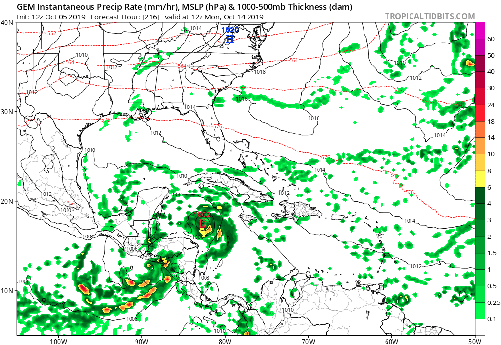
toad strangler wrote:gatorcane wrote:12Z GEM joining the GFS with development but sends it NW into the NW Carib:
https://i.postimg.cc/QdrvtBwB/gem-mslp-pcpn-watl-36.png
Trough-ridge setup at 234 hours:
CMC is showing a similar ridge to the GFS and Euro. I don't buy 500mb setups this far out. The story is that a storm in the SW Caribbean seems more and more likely. The Euro being left in the dust.
Speaking of dust, we’ve got a ton of it in the southeast US. Drought. Why? This stupid high pressure stuck over the southeast US. It cut short the FL rainy season and just like a GFS forecast, the action is always pushed out in time when looking at NWS daily forecasts. My bet is that this death ridge refuses to move until winter arrives.
0 likes

Re: 2019 Tropics: Global Model Runs Discussion (Out to day 16)
GeneratorPower wrote:toad strangler wrote:gatorcane wrote:12Z GEM joining the GFS with development but sends it NW into the NW Carib:
https://i.postimg.cc/QdrvtBwB/gem-mslp-pcpn-watl-36.png
Trough-ridge setup at 234 hours:
CMC is showing a similar ridge to the GFS and Euro. I don't buy 500mb setups this far out. The story is that a storm in the SW Caribbean seems more and more likely. The Euro being left in the dust.
Speaking of dust, we’ve got a ton of it in the southeast US. Drought. Why? This stupid high pressure stuck over the southeast US. It cut short the FL rainy season and just like a GFS forecast, the action is always pushed out in time when looking at NWS daily forecasts. My bet is that this death ridge refuses to move until winter arrives.
I have a hard time buying forecast storm development beyond a week; i'm certainly not betting the farm on the projected 7 + day 500mb flow. Still need at least a couple days to see how CONUS steering flow may set up
1 likes
Andy D
(For official information, please refer to the NHC and NWS products.)
(For official information, please refer to the NHC and NWS products.)
-
floridasun78
- Category 5

- Posts: 3755
- Joined: Sun May 17, 2009 10:16 pm
- Location: miami fl
Re: 2019 Tropics: Global Model Runs Discussion (Out to day 16)
chaser1 wrote:GeneratorPower wrote:toad strangler wrote:
CMC is showing a similar ridge to the GFS and Euro. I don't buy 500mb setups this far out. The story is that a storm in the SW Caribbean seems more and more likely. The Euro being left in the dust.
Speaking of dust, we’ve got a ton of it in the southeast US. Drought. Why? This stupid high pressure stuck over the southeast US. It cut short the FL rainy season and just like a GFS forecast, the action is always pushed out in time when looking at NWS daily forecasts. My bet is that this death ridge refuses to move until winter arrives.
I have a hard time buying forecast storm development beyond a week; i'm certainly not betting the farm on the projected 7 + day 500mb flow. Still need at least a couple days to see how CONUS steering flow may set up
you right 200 hour models cannot be trust i look at 120 hour ranger or so
0 likes
Re: 2019 Tropics: Global Model Runs Discussion (Out to day 16)
Not sure how the run will end, but 12z euro seems to be hinting at developing a low in the SW caribbean in about 7-8 days time. First time I've seen the Ops Euro do this, i think.
1 likes
-
gatorcane

- S2K Supporter
- Posts: 23708
- Age: 48
- Joined: Sun Mar 13, 2005 3:54 pm
- Location: Boca Raton, FL
Re: 2019 Tropics: Global Model Runs Discussion (Out to day 16)
The Euro looks to drive a weak broad low into Nicaragua. 12Z GEFS OTOH has a cluster off of Belize in the super-long range:
0 likes
Re: 2019 Tropics: Global Model Runs Discussion (Out to day 16)
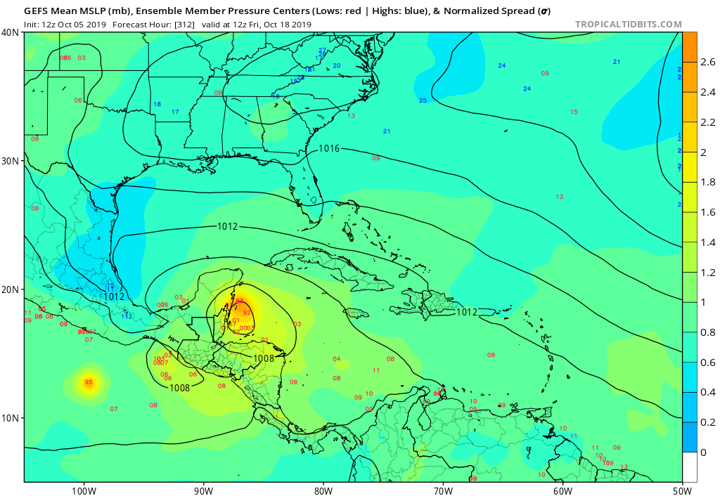
Through 264 hours, it looks like around 10-11 of the 51 EPS members develop a TC in the Western Caribbean. I believe this is the biggest signal for potential development that the EPS has shown so far.
Edit: Some move west into Central America, but the majority move north west and end up moving into the GOM or over Cuba. Obviously this far out any tracks are still highly suspect.
Edit: Some move west into Central America, but the majority move north west and end up moving into the GOM or over Cuba. Obviously this far out any tracks are still highly suspect.
Last edited by WxEp on Sat Oct 05, 2019 2:49 pm, edited 2 times in total.
3 likes
The posts in this forum are NOT official forecast and should not be used as such. They are just the opinion of the poster and may or may not be backed by sound meteorological data. They are NOT endorsed by any professional institution or STORM2K. For official information, refer to products from the National Hurricane Center and National Weather Service.
-
gatorcane
- S2K Supporter
- Posts: 23708
- Age: 48
- Joined: Sun Mar 13, 2005 3:54 pm
- Location: Boca Raton, FL
Re: 2019 Tropics: Global Model Runs Discussion (Out to day 16)
WxEp wrote:Through 264 hours, it looks like around 10-11 of the 51 EPS members develop a TC in the Western Caribbean. I believe this is the biggest signal for potential development that the EPS has shown so far.
Indeed and most of the ensembles lift this north or NW towards the NW Caribbean not into Nicaragua.
0 likes

-
SFLcane

- S2K Supporter
- Posts: 10281
- Age: 48
- Joined: Sat Jun 05, 2010 1:44 pm
- Location: Lake Worth Florida
Re: 2019 Tropics: Global Model Runs Discussion (Out to day 16)
gatorcane wrote:The Euro looks to drive a weak broad low into Nicaragua. 12Z GEFS OTOH has a cluster off of Belize in the super-long range:
https://i.postimg.cc/m24Hs59W/gfs-ememb-lowlocs-watl-53.png
EPS has picked up a bit today heading NE towards FL.
0 likes
-
Aric Dunn
- Category 5
- Posts: 21238
- Age: 43
- Joined: Sun Sep 19, 2004 9:58 pm
- Location: Ready for the Chase.
- Contact:
Re: 2019 Tropics: Global Model Runs Discussion (Out to day 16)
I think our best bet in the short term will be that mid to upper low east of the Bahamas. Models are very likely under doing and going to under do the amount of surface reflection that will develop,. it will likely be Sub tropical at first.
1 likes
Note: If I make a post that is brief. Please refer back to previous posts for the analysis or reasoning. I do not re-write/qoute what my initial post said each time.
If there is nothing before... then just ask
Space & Atmospheric Physicist, Embry-Riddle Aeronautical University,
I believe the sky is falling...
If there is nothing before... then just ask
Space & Atmospheric Physicist, Embry-Riddle Aeronautical University,
I believe the sky is falling...
-
SFLcane
- S2K Supporter
- Posts: 10281
- Age: 48
- Joined: Sat Jun 05, 2010 1:44 pm
- Location: Lake Worth Florida
Re: 2019 Tropics: Global Model Runs Discussion (Out to day 16)
18z GFS again buries this into CA.
0 likes
-
SFLcane
- S2K Supporter
- Posts: 10281
- Age: 48
- Joined: Sat Jun 05, 2010 1:44 pm
- Location: Lake Worth Florida
Re: 2019 Tropics: Global Model Runs Discussion (Out to day 16)
18z GEFS most if not all avoid Central America.
1 likes
-
Astromanía
- Category 2

- Posts: 798
- Age: 27
- Joined: Sat Aug 25, 2018 10:34 pm
- Location: Monterrey, N.L, México
Re: 2019 Tropics: Global Model Runs Discussion (Out to day 16)
Models are more consistent with the system in the EPAC, weaker than past runs tho
0 likes
-
gatorcane
- S2K Supporter
- Posts: 23708
- Age: 48
- Joined: Sun Mar 13, 2005 3:54 pm
- Location: Boca Raton, FL
Re: 2019 Tropics: Global Model Runs Discussion (Out to day 16)
SFLcane wrote:18z GEFS most if not all avoid Central America.
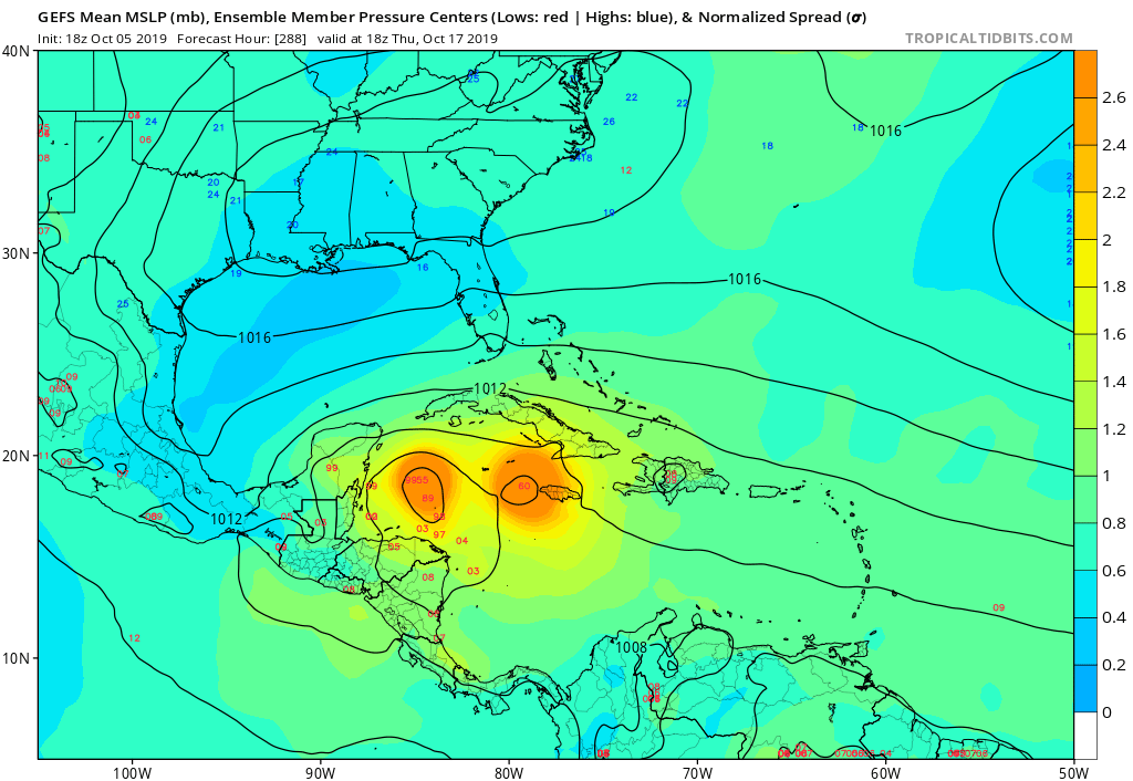
I think they do this because they generally delay development allowing for the ridge over the Gulf and Florida to weaken. The GFS op is faster with development from the CAG. Would not surprise me if we see slower and more gradual development as the models can try to spin up lows from gyres too quickly. The EPS and GEFS are slower and more gradual for the most part:
18Z GEFS below:
3 likes
Re: 2019 Tropics: Global Model Runs Discussion (Out to day 16)
Ridge setting up further east this run. Might get interesting
0 likes
-
Hurricaneman

- Category 5
- Posts: 7404
- Age: 45
- Joined: Tue Aug 31, 2004 3:24 pm
- Location: central florida
Re: 2019 Tropics: Global Model Runs Discussion (Out to day 16)
Bhuggs wrote:Ridge setting up further east this run. Might get interesting
Yep, this run of the GFS is 20 to 30mi from being a major problem for somebody, trending towards the ensembles
1 likes
-
WeatherEmperor
- S2K Supporter
- Posts: 4806
- Age: 42
- Joined: Thu Sep 04, 2003 2:54 pm
- Location: South Florida
Re: 2019 Tropics: Global Model Runs Discussion (Out to day 16)
GFS, Canadian and ICON on board


Sent from my iPhone using Tapatalk
Sent from my iPhone using Tapatalk
1 likes
Re: 2019 Tropics: Global Model Runs Discussion (Out to day 16)
WeatherEmperor wrote:GFS, Canadian and ICON on board
https://uploads.tapatalk-cdn.com/20191006/d301c0e49cca5a082d397b3385e4e217.png
https://uploads.tapatalk-cdn.com/20191006/a70580369ddf0d4507529ef3acadce8d.png
https://uploads.tapatalk-cdn.com/20191006/1925c0d2876226494c18a7107e2badfb.png
Sent from my iPhone using Tapatalk
And THIS, right now is one of the only two things that really matter right now. Not whether it will or wont be "a major". Not whether it looks right now like it'll track north, east, south, or west. What else is significant right now? 168 hours
5 likes
Andy D
(For official information, please refer to the NHC and NWS products.)
(For official information, please refer to the NHC and NWS products.)
Re: 2019 Tropics: Global Model Runs Discussion (Out to day 16)
WxEp wrote:Through 264 hours, it looks like around 10-11 of the 51 EPS members develop a TC in the Western Caribbean. I believe this is the biggest signal for potential development that the EPS has shown so far.
Edit: Some move west into Central America, but the majority move north west and end up moving into the GOM or over Cuba. Obviously this far out any tracks are still highly suspect.
This fairly sharp increase in EPS activity to ~20% of members along with the GEFS finally showing signs of progressing/sticking with a busy 0Z on 10/18 is now starting to get me a bit concerned. That doesn't mean I think we should panic though. It just bares watching a bit more than it did earlier imo.
For example, here is the 0Z GEFS for 0Z on 10/18, my benchmark timeframe:

Last edited by LarryWx on Sun Oct 06, 2019 1:56 am, edited 1 time in total.
1 likes
Personal Forecast Disclaimer:
The posts in this forum are NOT official forecasts and should not be used as such. They are just the opinion of the poster and may or may not be backed by sound meteorological data. They are NOT endorsed by any professional institution or storm2k.org. For official information, please refer to the NHC and NWS products.
The posts in this forum are NOT official forecasts and should not be used as such. They are just the opinion of the poster and may or may not be backed by sound meteorological data. They are NOT endorsed by any professional institution or storm2k.org. For official information, please refer to the NHC and NWS products.
Who is online
Users browsing this forum: No registered users and 208 guests