2019 Tropics: Global Model Runs Discussion (Out to day 16)
Moderator: S2k Moderators
Forum rules

The posts in this forum are NOT official forecasts and should not be used as such. They are just the opinion of the poster and may or may not be backed by sound meteorological data. They are NOT endorsed by any professional institution or STORM2K. For official information, please refer to products from the National Hurricane Center and National Weather Service.
-
SFLcane

- S2K Supporter

- Posts: 10281
- Age: 48
- Joined: Sat Jun 05, 2010 1:44 pm
- Location: Lake Worth Florida
Re: 2019 Tropics: Global Model Runs Discussion (Out to day 16)
Euro has nothing in the carib stronger system as expected in the e-pac.
0 likes
-
toad strangler

- S2K Supporter
- Posts: 4546
- Joined: Sun Jul 28, 2013 3:09 pm
- Location: Earth
- Contact:
Re: 2019 Tropics: Global Model Runs Discussion (Out to day 16)
12z Euro looks like it has a vortex spin up down in the suspect area at 216 hours.
0 likes
My Weather Station
https://www.wunderground.com/dashboard/pws/KFLPORTS603
https://www.wunderground.com/dashboard/pws/KFLPORTS603
-
SFLcane
- S2K Supporter
- Posts: 10281
- Age: 48
- Joined: Sat Jun 05, 2010 1:44 pm
- Location: Lake Worth Florida
Re: 2019 Tropics: Global Model Runs Discussion (Out to day 16)
In terms of any vorticity shown by the euro near panama this is not a tc. Higher than normal pressure. Euro can be biased to though

Last edited by SFLcane on Fri Oct 04, 2019 2:10 pm, edited 1 time in total.
0 likes
-
toad strangler
- S2K Supporter
- Posts: 4546
- Joined: Sun Jul 28, 2013 3:09 pm
- Location: Earth
- Contact:
Re: 2019 Tropics: Global Model Runs Discussion (Out to day 16)
12z GFS and 12z Euro vort maps look very similar at 240 hours
2 likes
My Weather Station
https://www.wunderground.com/dashboard/pws/KFLPORTS603
https://www.wunderground.com/dashboard/pws/KFLPORTS603

Re: 2019 Tropics: Global Model Runs Discussion (Out to day 16)
Definitely reinforcing the idea that this is the area needs to be watched with the 12z runs.
0 likes
Re: 2019 Tropics: Global Model Runs Discussion (Out to day 16)
The 12Z EPS is again very quiet with a mere 3 sub 999 TCs in/near the W Caribbean out of 51 members as of 0Z on 10/18...so only 6%.
So, the 12Z versions of the EPS and the often overly aggressive GEPS are quiet for 10/18 vs the very active GEFS. Who do you believe? I'm certainly not overly concerned at this time.
So, the 12Z versions of the EPS and the often overly aggressive GEPS are quiet for 10/18 vs the very active GEFS. Who do you believe? I'm certainly not overly concerned at this time.
1 likes
Personal Forecast Disclaimer:
The posts in this forum are NOT official forecasts and should not be used as such. They are just the opinion of the poster and may or may not be backed by sound meteorological data. They are NOT endorsed by any professional institution or storm2k.org. For official information, please refer to the NHC and NWS products.
The posts in this forum are NOT official forecasts and should not be used as such. They are just the opinion of the poster and may or may not be backed by sound meteorological data. They are NOT endorsed by any professional institution or storm2k.org. For official information, please refer to the NHC and NWS products.


Re: 2019 Tropics: Global Model Runs Discussion (Out to day 16)
When is the next kelvin wave due?
0 likes
-
SFLcane
- S2K Supporter
- Posts: 10281
- Age: 48
- Joined: Sat Jun 05, 2010 1:44 pm
- Location: Lake Worth Florida
Re: 2019 Tropics: Global Model Runs Discussion (Out to day 16)
LarryWx wrote:The 12Z EPS is again very quiet with a mere 3 sub 999 TCs in/near the W Caribbean out of 51 members as of 0Z on 10/18...so only 6%.
So, the 12Z versions of the EPS and the often overly aggressive GEPS are quiet for 10/18 vs the very active GEFS. Who do you believe? I'm certainly not overly concerned at this time.
My takeaway is don't get worked up about Day 10+ forecasts.
3 likes

Re: 2019 Tropics: Global Model Runs Discussion (Out to day 16)
toad strangler wrote:12z GFS and 12z Euro vort maps look very similar at 240 hours
Agreed, very similar. The GFS ensemble and the Euro Operational. This area needs to be watched closely now.
GEFS 240hr

Euro Operational 240hr

2 likes
The following post is NOT an official forecast and should not be used as such. It is just the opinion of the poster and may or may not be backed by sound meteorological data. It is NOT endorsed by any professional institution including storm2k.org For Official Information please refer to the NHC and NWS products.
Re: 2019 Tropics: Global Model Runs Discussion (Out to day 16)
One of the earliest genesis so far in gfs. Around hour 204. Also coming up on a week straight of runs showing a system in this area.
0 likes
-
gatorcane

- S2K Supporter
- Posts: 23703
- Age: 47
- Joined: Sun Mar 13, 2005 3:54 pm
- Location: Boca Raton, FL
Re: 2019 Tropics: Global Model Runs Discussion (Out to day 16)
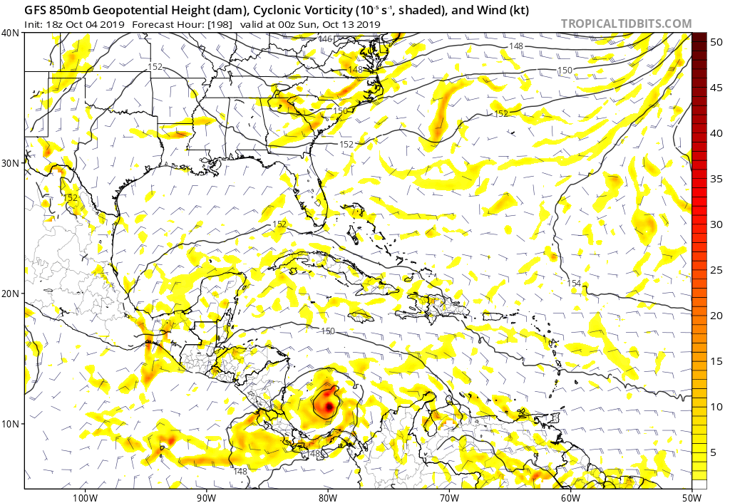
Indeed GFS shows genesis at 198 hours. So like I have been saying, likely not a phantom as clearly the timeframe is coming in. Note sure about that track into Central America, too far out to know if that is the outcome. Chances are it tracks NW into the NW Caribbean.
3 likes
-
SFLcane
- S2K Supporter
- Posts: 10281
- Age: 48
- Joined: Sat Jun 05, 2010 1:44 pm
- Location: Lake Worth Florida
Re: 2019 Tropics: Global Model Runs Discussion (Out to day 16)
So for the first time the gfs is now showing development near 170-180hrs. It brought in the time let’s see if it sticks
0 likes
-
gatorcane
- S2K Supporter
- Posts: 23703
- Age: 47
- Joined: Sun Mar 13, 2005 3:54 pm
- Location: Boca Raton, FL
Re: 2019 Tropics: Global Model Runs Discussion (Out to day 16)
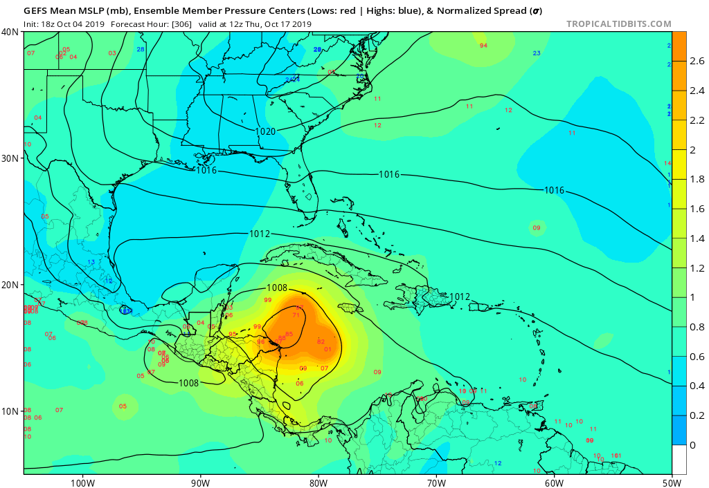
Very active GEFS again 18z below. Most head NW into the NW Carib:
2 likes
-
SFLcane
- S2K Supporter
- Posts: 10281
- Age: 48
- Joined: Sat Jun 05, 2010 1:44 pm
- Location: Lake Worth Florida
Re: 2019 Tropics: Global Model Runs Discussion (Out to day 16)
gatorcane wrote:Very active GEFS again 18z below. Most head NW into the NW Carib:
https://i.postimg.cc/QMZnxs3b/gfs-ememb-lowlocs-watl-52.png
They do form earlier now let’s see if we get some consistency.
0 likes
Re: 2019 Tropics: Global Model Runs Discussion (Out to day 16)
The Ukmet is starting to hunt at vorticity in the area.

0 likes
The following post is NOT an official forecast and should not be used as such. It is just the opinion of the poster and may or may not be backed by sound meteorological data. It is NOT endorsed by any professional institution including storm2k.org For Official Information please refer to the NHC and NWS products.
Re: 2019 Tropics: Global Model Runs Discussion (Out to day 16)
So CMC, GFS, Euro, Ukmet are showing something.
Last edited by blp on Fri Oct 04, 2019 8:33 pm, edited 1 time in total.
1 likes
The following post is NOT an official forecast and should not be used as such. It is just the opinion of the poster and may or may not be backed by sound meteorological data. It is NOT endorsed by any professional institution including storm2k.org For Official Information please refer to the NHC and NWS products.
-
gatorcane
- S2K Supporter
- Posts: 23703
- Age: 47
- Joined: Sun Mar 13, 2005 3:54 pm
- Location: Boca Raton, FL
Re: 2019 Tropics: Global Model Runs Discussion (Out to day 16)
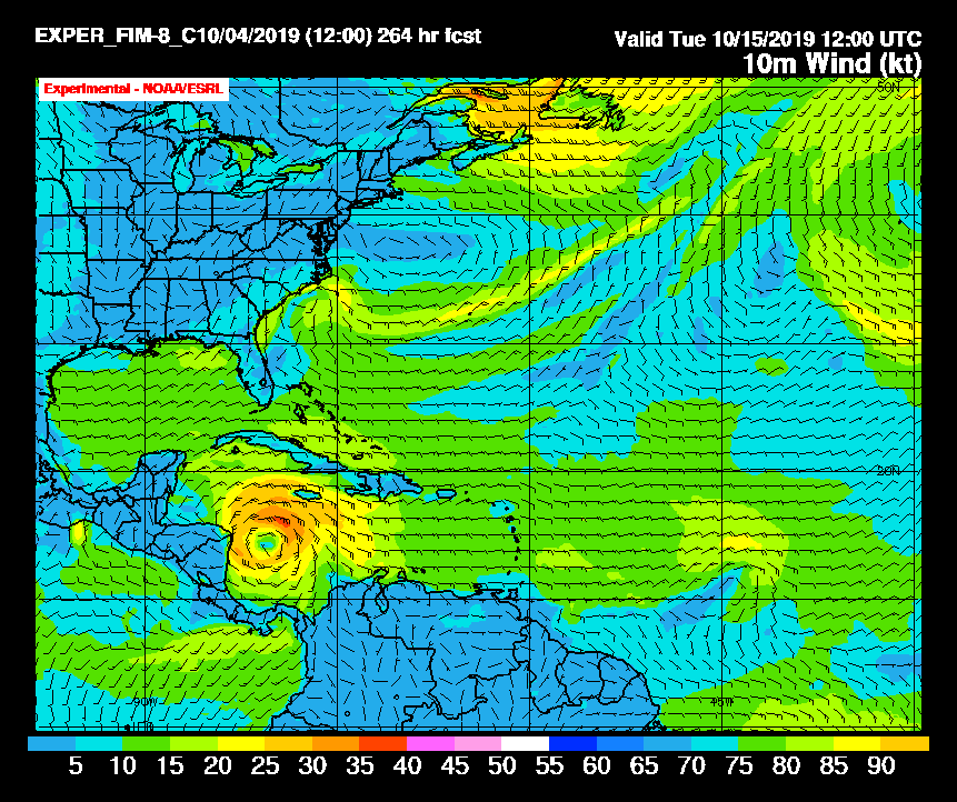
Looks like the experimental 30KM FIM (Finite Volume Icosahedral) model runs at 00Z and 12Z daily out to 336 hours. It also shows SW Caribbean development and take it WNW towards the Yucatán/Belize area. I believe the model is based on the GFS model fields. Wonder if it is using the new FV3 core?
From the FAQ though it has not been updated since 2016:
“Q: What global data is used to initialize the real-time FIM model forecasts?
A: GFS spectral grids interpolated to FIM icosahedral/isentropic-hybrid coordinates up to this point (11/2008)”
By the way looks like they are also testing an experimental 13KM FV3 (higher resolution) albeit only out through 120 hours and only runs at 00Z.
Link to bookmark:
https://fim.noaa.gov/
1 likes
-
USTropics
- Professional-Met

- Posts: 2734
- Joined: Sun Aug 12, 2007 3:45 am
- Location: Florida State University
Re: 2019 Tropics: Global Model Runs Discussion (Out to day 16)
gatorcane wrote:Indeed GFS shows genesis at 198 hours. So like I have been saying, likely not a phantom as clearly the timeframe is coming in. Note sure about that track into Central America, too far out to know if that is the outcome. Chances are it tracks NW into the NW Caribbean.
https://i.postimg.cc/rwpTJV4p/gfs-z850-vort-watl-34.png
If genesis were to occur in this area, climatology would suggest this as well. Below are the tracks of systems that have formed in the deep SE Caribbean in the month of October (1842-2018):

Full list:
Code: Select all
Beta, 2005
Floyd, 1987
Fox, 1952
Gladys, 1968
Hattie,   1961
Isbell,   1964
Judith,   1959
Katie, 1955
Katrina, 1999
Lili, 1996
Michelle, 2001
Mitch, 1998
Nate, 2017
Paula, 2010
Rina, 2011
Roxanne, 1995
Sandy, 2012
Unnamed, 1865
Unnamed, 1874
Unnamed, 1876
Unnamed, 1879
Unnamed, 1882
Unnamed, 1890
Unnamed, 1891
Unnamed, 1894
Unnamed, 1905
Unnamed, 1906
Unnamed, 1908
Unnamed, 1909
Unnamed, 1910
Unnamed, 1921
Unnamed, 1922
Unnamed   #1, 1926
Unnamed   #2, 1926
Unnamed, 1933
Unnamed, 1935
Unnamed, 1940
Unnamed, 1945
Unnamed, 1947
Unnamed, 1975
Unnamed, 1979
3 likes
Re: 2019 Tropics: Global Model Runs Discussion (Out to day 16)
In later frames the GFS has the storm crossing Eastern Cuba than thru the Bahamas well east of Florida but the time frame is just about in medium range.
0 likes

Re: 2019 Tropics: Global Model Runs Discussion (Out to day 16)
Quick note, add the ICON at 180 hr's beginning to focus on SW Caribbean development as well. Also, the 0Z GFS seems to clearly indicate distinctly lower pressures as compared to recent runs as early now as 132 hr's. At 190 hr's there's a large closed 1004 low depicted in the SW Carib. Realizing that the time frame is far too distant to focus on details at this time, there does appear to be a suggestion of development beginning to occur at the 10/13 - 10/14 time frame.
0 likes
Andy D
(For official information, please refer to the NHC and NWS products.)
(For official information, please refer to the NHC and NWS products.)
Who is online
Users browsing this forum: gib and 46 guests