ATL: KAREN - Models
Moderator: S2k Moderators
-
toad strangler

- S2K Supporter

- Posts: 4546
- Joined: Sun Jul 28, 2013 3:09 pm
- Location: Earth
- Contact:
Re: ATL: KAREN - Models
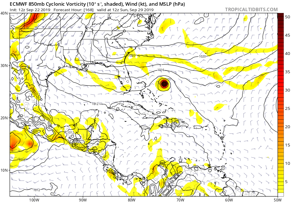
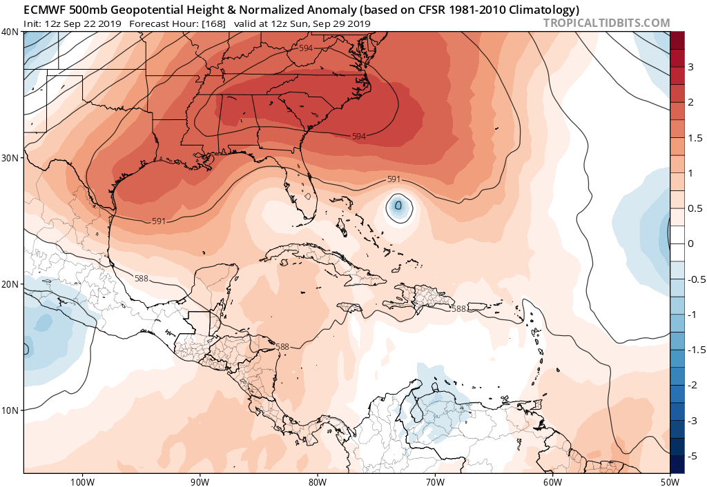
And that 12z Euro ridge at 144 hrs 
0 likes
My Weather Station
https://www.wunderground.com/dashboard/pws/KFLPORTS603
https://www.wunderground.com/dashboard/pws/KFLPORTS603


Re: ATL: KAREN - Models
Rapidly gaining strength at hour 168 and beelining dead west. Reminds me of Dorian (hope it recurves too!)
0 likes
Very useful information on the Dvorak Technique --
https://severe.worldweather.wmo.int/TCF ... kBeven.pdf
https://severe.worldweather.wmo.int/TCF ... kBeven.pdf
-
toad strangler
- S2K Supporter
- Posts: 4546
- Joined: Sun Jul 28, 2013 3:09 pm
- Location: Earth
- Contact:
Re: ATL: KAREN - Models
Good Lord look at that ridge at 168 hrs.
0 likes
My Weather Station
https://www.wunderground.com/dashboard/pws/KFLPORTS603
https://www.wunderground.com/dashboard/pws/KFLPORTS603


Re: ATL: KAREN - Models
Unrelated to Karen itself, I wonder if we're going to have a third time now with something passing near Florida and the upper disturbance that helped steer it north develops in the Gulf after--the pattern almost seems like it's on a weird repeat setting.
1 likes
The above post is not official and should not be used as such. It is the opinion of the poster and may or may not be backed by sound meteorological data. It is not endorsed by any professional institution or storm2k.org. For official information, please refer to the NHC and NWS products.
-
WeatherEmperor
- S2K Supporter
- Posts: 4806
- Age: 42
- Joined: Thu Sep 04, 2003 2:54 pm
- Location: South Florida

-
toad strangler
- S2K Supporter
- Posts: 4546
- Joined: Sun Jul 28, 2013 3:09 pm
- Location: Earth
- Contact:
Re: ATL: KAREN - Models
12z Euro right into Palm Beach County with VERBATIM a high end TS or Cat 1 Hurricane.
Last edited by toad strangler on Sun Sep 22, 2019 1:44 pm, edited 1 time in total.
0 likes
My Weather Station
https://www.wunderground.com/dashboard/pws/KFLPORTS603
https://www.wunderground.com/dashboard/pws/KFLPORTS603
-
toad strangler
- S2K Supporter
- Posts: 4546
- Joined: Sun Jul 28, 2013 3:09 pm
- Location: Earth
- Contact:
Re: ATL: KAREN - Models
With that uber ridge this will easily get into the Gulf this run.
0 likes
My Weather Station
https://www.wunderground.com/dashboard/pws/KFLPORTS603
https://www.wunderground.com/dashboard/pws/KFLPORTS603
Re: ATL: KAREN - Models
toad strangler wrote:12z Euro still much weaker than 0z but that's not the key here this far out. The key is that persistent left turn which has already happened on 12z Euro.
Agreed. I would go even further to say being weaker is meaningless, if you want to argue over 980mb vs 998 mb. Those details this far out and strike point (miami, wpb, cuba, etc) also not important. The only thing of concern for the US is whether the Euro is "locking in" on an idea
3 likes
-
AxaltaRacing24
- Category 5

- Posts: 1774
- Age: 25
- Joined: Wed Jul 27, 2016 11:14 am
- Location: Jupiter, FL
Re: ATL: KAREN - Models
Hammy wrote:
Unrelated to Karen itself, I wonder if we're going to have a third time now with something passing near Florida and the upper disturbance that helped steer it north develops in the Gulf after--the pattern almost seems like it's on a weird repeat setting.
I’ve never begged for a shortwave or trough more than now. The Bahamas don’t need this.
0 likes
-
toad strangler
- S2K Supporter
- Posts: 4546
- Joined: Sun Jul 28, 2013 3:09 pm
- Location: Earth
- Contact:
Re: ATL: KAREN - Models
Also on this run, right over the hardest hit areas from Dorian.
0 likes
My Weather Station
https://www.wunderground.com/dashboard/pws/KFLPORTS603
https://www.wunderground.com/dashboard/pws/KFLPORTS603
-
AxaltaRacing24
- Category 5
- Posts: 1774
- Age: 25
- Joined: Wed Jul 27, 2016 11:14 am
- Location: Jupiter, FL
Re: ATL: KAREN - Models
sma10 wrote:toad strangler wrote:12z Euro still much weaker than 0z but that's not the key here this far out. The key is that persistent left turn which has already happened on 12z Euro.
Agreed. I would go even further to say being weaker is meaningless, if you want to argue over 980mb vs 998 mb. Those details this far out and strike point (miami, wpb, cuba, etc) also not important. The only thing of concern for the US is whether the Euro is "locking in" on an idea
My concern is how the euro has been committed to this turn. If it stays committed when the timeframe for a turn decreases to 3-4 days out, then we really need to watch this.
0 likes
-
toad strangler
- S2K Supporter
- Posts: 4546
- Joined: Sun Jul 28, 2013 3:09 pm
- Location: Earth
- Contact:
Re: ATL: KAREN - Models
This Euro run is pretty fast so if this played out it would be a IN and OUT type scenario, which is always the preferred method wherever a hit occurs.
0 likes
My Weather Station
https://www.wunderground.com/dashboard/pws/KFLPORTS603
https://www.wunderground.com/dashboard/pws/KFLPORTS603
-
CrazyC83
- Professional-Met

- Posts: 34315
- Joined: Tue Mar 07, 2006 11:57 pm
- Location: Deep South, for the first time!
Re: ATL: KAREN - Models
This is certainly not a pattern you'd expect at the end of September or beginning of October though. That looks like a track you'd be more apt to see in August.
5 likes
Re: ATL: KAREN - Models
toad strangler wrote:This Euro run is pretty fast so if this played out it would be a IN and OUT type scenario, which is always the preferred method wherever a hit occurs.
Yes which of course, implies a very sturdy, strong ridge
Last edited by sma10 on Sun Sep 22, 2019 1:53 pm, edited 1 time in total.
0 likes
Re: ATL: KAREN - Models
CrazyC83 wrote:This is certainly not a pattern you'd expect at the end of September or beginning of October though. That looks like a track you'd be more apt to see in August.
That’s what happens when no cold fronts are coming down which is why you have to throw climo out the window right now.
1 likes
Re: ATL: KAREN - Models
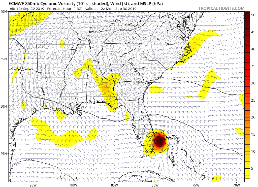
12Z Euro hits central LA 234-240 (10/2) due to a turn to the NW.
Last edited by LarryWx on Sun Sep 22, 2019 1:57 pm, edited 2 times in total.
0 likes
Personal Forecast Disclaimer:
The posts in this forum are NOT official forecasts and should not be used as such. They are just the opinion of the poster and may or may not be backed by sound meteorological data. They are NOT endorsed by any professional institution or storm2k.org. For official information, please refer to the NHC and NWS products.
The posts in this forum are NOT official forecasts and should not be used as such. They are just the opinion of the poster and may or may not be backed by sound meteorological data. They are NOT endorsed by any professional institution or storm2k.org. For official information, please refer to the NHC and NWS products.
Who is online
Users browsing this forum: No registered users and 88 guests