Disturbed weather in GOM (Is INVEST 98L)
Moderator: S2k Moderators
Forum rules

The posts in this forum are NOT official forecasts and should not be used as such. They are just the opinion of the poster and may or may not be backed by sound meteorological data. They are NOT endorsed by any professional institution or STORM2K. For official information, please refer to products from the National Hurricane Center and National Weather Service.

Re: Disturbed weather in GOM
Doesn't look healthy...or very wet...at all this afternoon on satellite.
0 likes
-
jasons2k

- Storm2k Executive

- Posts: 8290
- Age: 52
- Joined: Wed Jul 06, 2005 12:32 pm
- Location: The Woodlands, TX
Re: Disturbed weather in GOM
SoupBone wrote:Is it just my eyes, or does this system appear to be drying up some? Much less flaring than earlier.
DMIN
1 likes


Re: Disturbed weather in GOM
jasons wrote:SoupBone wrote:Is it just my eyes, or does this system appear to be drying up some? Much less flaring than earlier.
DMIN
Thanks, does DMIN also remove or limit moisture content, because it looks like it's drying up too.
0 likes
Personal Forecast Disclaimer:
The posts in this forum are NOT official forecast and should not be used as such. They are just the opinion of the poster and may or may not be backed by sound meteorological data. They are NOT endorsed by any professional institution or storm2k.org. For official information, please refer to the NHC and NWS products.
The posts in this forum are NOT official forecast and should not be used as such. They are just the opinion of the poster and may or may not be backed by sound meteorological data. They are NOT endorsed by any professional institution or storm2k.org. For official information, please refer to the NHC and NWS products.
-
jasons2k
- Storm2k Executive
- Posts: 8290
- Age: 52
- Joined: Wed Jul 06, 2005 12:32 pm
- Location: The Woodlands, TX
Re: Disturbed weather in GOM
Update from Jeff Lindner:
Heavy rainfall threat increasing for SE TX
Flash flooding will be possible especially mid week
Discussion:
Ill defined area of broad low pressure over the NW Gulf of Mexico within a surface trough just to the east of an upper level low pressure system nearing the middle TX coast. Showers and a few thunderstorms have rotated inland today northward to roughly the I-10 corridor with brief heavy rainfall and gusty winds. Broad area of low pressure will move generally toward the Matagorda Bay area and may become slightly better defined on Tuesday into early Wednesday morning. Low level wind field respond to the slight deepening of the low and show a decent onshore flow developing Tuesday night over the central portions of the area. Moisture levels will begin to surge upward on Tuesday and remain extremely high levels into Wednesday and Thursday as surface low/trough meanders N west of I-45 across the region. Concern increases Tuesday night onward for the potential for training and clusters of heavy rainfall to move south to north over the region on that favored east side of the surface low/trough.
Rainfall Amounts:
Model output today has been in fair agreement on the placement of the heavier rainfall across portions of SE TX, but vary wildly on the expected amounts. Best course of action at this time is to follow WPC guidance and blend the various amounts and locations in a more smoothed fashion instead of taking the extremes on either end of the model spectrum. Widespread rainfall amounts of 4-6 inches is likely with isolated totals of 10-15 inches. The widespread amounts may need to be raise more if guidance continues with its increasing signal.
With the atmosphere becoming increasingly saturated, storms will become very efficient rainfall producers and hourly rainfall rates of 2-4 inches will be possible which will lead to rapid flash flooding over streets and areas of poor drainage.
Flood Potential:
While grounds are very dry across the region with current 2 inch depth soil moisture running 20-30% across much of Harris County, intense rainfall rates and the gradual saturation of the soils will lead to increasing run-off potential. Timing of rainfall amounts will be critical in the eventual outcome of flooding and the degree. Sustained heavy rainfall over several hours will likely result in flooding while frequent bands with breaks in between the bands will help allow the rainfall to soak in some and reduce the amount of run-off. Given the current forecasted rainfall amounts, run-off especially by mid week looks likely with significant rises on area creeks, bayous, and rivers possible.
WPC has increased the threat for flash flooding into the moderate category for portions of the area on Wednesday.
Timing: onset Tuesday (scattered), heavier more sustained rains (Wednesday-Thursday)
Amounts: widespread 4-6 inches, isolated 10-15 inches
Street flooding: high
Channel flooding: moderate (up to 6 inches), high (over 6 inches) in a 6 hour period
2 likes
-
StormLogic

- Tropical Storm

- Posts: 201
- Joined: Mon Jun 03, 2019 9:58 am
- Location: Beaumont
Re: Disturbed weather in GOM
NAM looking really scary for SETX. Watch the models in animation, there will be banding setting up like we all know to well..Possible Harvey Event setting up again??? this un named storm is going to cause havoc and definitely be in the main stream media news in the coming days... They are under estimating this storm i can 100% tell you that.
this only 84hr total accumulated precip amounts. they will be higher....OK, going clean gutters...
NAM 12km did me right during Harvey, I have a feeling that this shall too steer me right. I'm thinking about heading to Austin tonight.

this only 84hr total accumulated precip amounts. they will be higher....OK, going clean gutters...
NAM 12km did me right during Harvey, I have a feeling that this shall too steer me right. I'm thinking about heading to Austin tonight.
1 likes
Personal Forecast Disclaimer:
The posts in this forum are NOT official forecast and should not be used as such. They are just the opinion of the poster and may or may not be backed by sound meteorological data. They are NOT endorsed by any professional institution or storm2k.org. For official information, please refer to the NHC and NWS products.
The posts in this forum are NOT official forecast and should not be used as such. They are just the opinion of the poster and may or may not be backed by sound meteorological data. They are NOT endorsed by any professional institution or storm2k.org. For official information, please refer to the NHC and NWS products.
-
jasons2k
- Storm2k Executive
- Posts: 8290
- Age: 52
- Joined: Wed Jul 06, 2005 12:32 pm
- Location: The Woodlands, TX
Re: Disturbed weather in GOM
SoupBone wrote:jasons wrote:SoupBone wrote:Is it just my eyes, or does this system appear to be drying up some? Much less flaring than earlier.
DMIN
Thanks, does DMIN also remove or limit moisture content, because it looks like it's drying up too.
All you ever wanted to know:
viewtopic.php?t=108938
0 likes
-
StormLogic
- Tropical Storm
- Posts: 201
- Joined: Mon Jun 03, 2019 9:58 am
- Location: Beaumont
Re: Disturbed weather in GOM
I also would think this has a 50% chance at becoming a TC now?
0 likes
Personal Forecast Disclaimer:
The posts in this forum are NOT official forecast and should not be used as such. They are just the opinion of the poster and may or may not be backed by sound meteorological data. They are NOT endorsed by any professional institution or storm2k.org. For official information, please refer to the NHC and NWS products.
The posts in this forum are NOT official forecast and should not be used as such. They are just the opinion of the poster and may or may not be backed by sound meteorological data. They are NOT endorsed by any professional institution or storm2k.org. For official information, please refer to the NHC and NWS products.


Re: Disturbed weather in GOM
Senobia wrote:Doesn't look healthy...or very wet...at all this afternoon on satellite.
I would send you a screenshot of my radar but don't know how
0 likes
Alicia, Rita, Ike, Harvey and Beryl...moved to Splendora lol
Re: Disturbed weather in GOM
StormLogic wrote:NAM looking really scary for SETX. Watch the models in animation, there will be banding setting up like we all know to well..Possible Harvey Event setting up again??? this un named storm is going to cause havoc
These models are still in Allison levels of flooding scenarios not Harvey levels, imo. The latter is going to require models ratcheting things up another order of magnitude.
1 likes

Re: Disturbed weather in GOM
StormLogic wrote:NAM looking really scary for SETX. Watch the models in animation, there will be banding setting up like we all know to well..Possible Harvey Event setting up again??? this un named storm is going to cause havoc and definitely be in the main stream media news in the coming days... They are under estimating this storm i can 100% tell you that.
this only 84hr total accumulated precip amounts. they will be higher....OK, going clean gutters...
NAM 12km did me right during Harvey, I have a feeling that this shall too steer me right. I'm thinking about heading to Austin tonight.
https://www.tropicaltidbits.com/analysis/models/namconus/2019091618/namconus_apcpn_us_28.png
That’s too far east. Heavier totals will be well west of that.
0 likes
Re: Disturbed weather in GOM
Please tell me there's no chance that it will sit in the Gulf and become an H word.
0 likes
Alicia, Rita, Ike, Harvey and Beryl...moved to Splendora lol
-
stormlover2013
Re: Disturbed weather in GOM
Help support Storm2K!
Cpv17 wrote:StormLogic wrote:NAM looking really scary for SETX. Watch the models in animation, there will be banding setting up like we all know to well..Possible Harvey Event setting up again??? this un named storm is going to cause havoc and definitely be in the main stream media news in the coming days... They are under estimating this storm i can 100% tell you that.
this only 84hr total accumulated precip amounts. they will be higher....OK, going clean gutters...
NAM 12km did me right during Harvey, I have a feeling that this shall too steer me right. I'm thinking about heading to Austin tonight.
https://www.tropicaltidbits.com/analysis/models/namconus/2019091618/namconus_apcpn_us_28.png
That’s too far east. Heavier totals will be well west of that.
Nobody knows these forecast are tough so I wouldn’t say that
2 likes
-
jasons2k
- Storm2k Executive
- Posts: 8290
- Age: 52
- Joined: Wed Jul 06, 2005 12:32 pm
- Location: The Woodlands, TX
Re: Disturbed weather in GOM
Like Jeff said you cannot focus on any one model or model bullseye. The best course is to monitor the WPC rainfall maps and watch for trends.
4 likes
-
StormLogic
- Tropical Storm
- Posts: 201
- Joined: Mon Jun 03, 2019 9:58 am
- Location: Beaumont
Re: Disturbed weather in GOM
mpic wrote:Please tell me there's no chance that it will sit in the Gulf and become an H word.
TS at best lol its running out of time
1 likes
Personal Forecast Disclaimer:
The posts in this forum are NOT official forecast and should not be used as such. They are just the opinion of the poster and may or may not be backed by sound meteorological data. They are NOT endorsed by any professional institution or storm2k.org. For official information, please refer to the NHC and NWS products.
The posts in this forum are NOT official forecast and should not be used as such. They are just the opinion of the poster and may or may not be backed by sound meteorological data. They are NOT endorsed by any professional institution or storm2k.org. For official information, please refer to the NHC and NWS products.
-
jasons2k
- Storm2k Executive
- Posts: 8290
- Age: 52
- Joined: Wed Jul 06, 2005 12:32 pm
- Location: The Woodlands, TX
Re: Disturbed weather in GOM
mpic wrote:Please tell me there's no chance that it will sit in the Gulf and become an H word.
Highly, highly doubtful, but there's always a chance until it moves onshore. It's never good to think of the weather in terms of absolutes like "no" "none" "zero" "all" etc. There can always be surprises. (Yes, I see the irony that "always" is another absolute hehe)
4 likes
Re: Disturbed weather in GOM
jasons wrote:Like Jeff said you cannot focus on any one model or model bullseye. The best course is to monitor the WPC rainfall maps and watch for trends.
If we're using the WPC graph, the entire Houston area will see upwards of 7", with some areas having the chance for higher. Houston, especially as dry as it's been, can handle 7" of rain, even widespread right now. Let's hope the the WPC is correct. There could still be some localized flooding too.
0 likes
Personal Forecast Disclaimer:
The posts in this forum are NOT official forecast and should not be used as such. They are just the opinion of the poster and may or may not be backed by sound meteorological data. They are NOT endorsed by any professional institution or storm2k.org. For official information, please refer to the NHC and NWS products.
The posts in this forum are NOT official forecast and should not be used as such. They are just the opinion of the poster and may or may not be backed by sound meteorological data. They are NOT endorsed by any professional institution or storm2k.org. For official information, please refer to the NHC and NWS products.
-
StormLogic
- Tropical Storm
- Posts: 201
- Joined: Mon Jun 03, 2019 9:58 am
- Location: Beaumont
Re: Disturbed weather in GOM
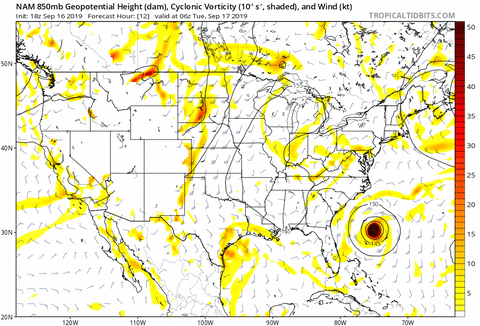
18z NAM spins her up over land
2 likes
Personal Forecast Disclaimer:
The posts in this forum are NOT official forecast and should not be used as such. They are just the opinion of the poster and may or may not be backed by sound meteorological data. They are NOT endorsed by any professional institution or storm2k.org. For official information, please refer to the NHC and NWS products.
The posts in this forum are NOT official forecast and should not be used as such. They are just the opinion of the poster and may or may not be backed by sound meteorological data. They are NOT endorsed by any professional institution or storm2k.org. For official information, please refer to the NHC and NWS products.
Re: Disturbed weather in GOM
stormlover2013 wrote:Help support Storm2K!
Cpv17 wrote:StormLogic wrote:NAM looking really scary for SETX. Watch the models in animation, there will be banding setting up like we all know to well..Possible Harvey Event setting up again??? this un named storm is going to cause havoc and definitely be in the main stream media news in the coming days... They are under estimating this storm i can 100% tell you that.
this only 84hr total accumulated precip amounts. they will be higher....OK, going clean gutters...
NAM 12km did me right during Harvey, I have a feeling that this shall too steer me right. I'm thinking about heading to Austin tonight.
https://www.tropicaltidbits.com/analysis/models/namconus/2019091618/namconus_apcpn_us_28.png
That’s too far east. Heavier totals will be well west of that.
Nobody knows these forecast are tough so I wouldn’t say that
Hey your area near Beaumont gets plenty of rain throughout the year lol send the rain west of Houston where it’s needed most. At least the WPC and Euro are still on my side.
2 likes

Re: Disturbed weather in GOM
0 likes
Who is online
Users browsing this forum: No registered users and 167 guests