2019 Indicators: SST'S / Sal / MSLP / Steering / Shear / Instability (See updated graphics at first post)
Moderator: S2k Moderators
Forum rules

The posts in this forum are NOT official forecasts and should not be used as such. They are just the opinion of the poster and may or may not be backed by sound meteorological data. They are NOT endorsed by any professional institution or STORM2K. For official information, please refer to products from the National Hurricane Center and National Weather Service.
-
gatorcane

- S2K Supporter

- Posts: 23708
- Age: 48
- Joined: Sun Mar 13, 2005 3:54 pm
- Location: Boca Raton, FL
Re: 2019 Indicators: SST'S / Sal / MSLP / Steering / Shear / Instability (See updated graphics at first post)
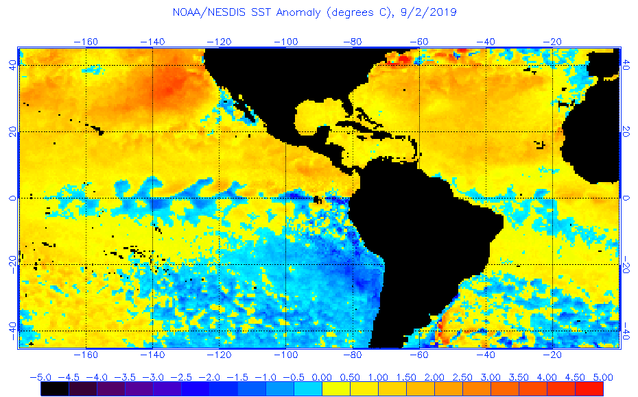
Look at all the above normal SSTs across the Atlantic and total lack of an El Niño signature in the EPAC.  Looks like the Atlantic is going to be active and quite possibly above normal when all is said and done.
7 likes

Re: 2019 Indicators: SST'S / Sal / MSLP / Steering / Shear / Instability (See updated graphics at first post)
Yeah. Fuel is there for sure.
We hit the G storm. Who was that old pro
Met poster who would always spot the posts brought to you by the letter _? I don’t know when G usually gets named but I’d assume September.
Yeah. 9/16
https://www.nhc.noaa.gov/climo/
We hit the G storm. Who was that old pro
Met poster who would always spot the posts brought to you by the letter _? I don’t know when G usually gets named but I’d assume September.
Yeah. 9/16
https://www.nhc.noaa.gov/climo/
1 likes
-
captainbarbossa19

- Professional-Met

- Posts: 1094
- Age: 27
- Joined: Wed Aug 21, 2019 11:09 pm
- Location: Beaumont, TX
Re: 2019 Indicators: SST'S / Sal / MSLP / Steering / Shear / Instability (See updated graphics at first post)
captainbarbossa19 wrote:captainbarbossa19 wrote:After years of watching S2K forums throughout the season, I think that many on this board go through a sequence of changing opinions. While this is not true every season, many seasons often follow this timeline.
1. June 1st: Everyone is excited about the upcoming season. Many are anticipating upcoming action later in the month, but most know that the real action will most likely start in August.
2. July 1st: One or two TCs manage to form in June. Many complain about how weak and disorganized the cyclones are.
3. July 15th: Lots of SAL is present in the Atlantic basin. However, most people are not surprised by this, as they were expecting it.
4. August 1st: Atlantic is still slow. Dry, stable air is present in the tropics. However, models are beginning to suggest things will be changing within a few weeks.
5. August 15th: Models show nothing in the near-future. Many are becoming skeptical about the season amounting to anything significant.
6. August 23rd: There are multiple invests in the Atlantic and conditions are rapidly beginning to change. The models begin to show cyclogenesis. Many quickly change their minds about a quieter season.
7. August 31st: There is now at least one active TC. There is a potential that at least one TC could become a hurricane. Many people appear shocked by the increased activity.
8. September 30th: Several TCs have already formed and dissipated. A few who suggested that the season would be quiet now state that they always knew the Atlantic would spring to life.
9. November 30th: The last storm probably has dissipated by this point. Many look back at the season and state that they are surprised with the outcome.
I believe I should add in my list a tenth point, "August 24th: Some experts continue to doubt signs of the Atlantic awakening. These experts issue outlooks that support original ideas of a quieter season."
Well, we are well on our way now to No. 9 now. After No. 10, we shall wait until June, and the cycle will probably start again.
2 likes
-
toad strangler

- S2K Supporter
- Posts: 4546
- Joined: Sun Jul 28, 2013 3:09 pm
- Location: Earth
- Contact:
Re: 2019 Indicators: SST'S / Sal / MSLP / Steering / Shear / Instability (See updated graphics at first post)
gatorcane wrote:Look at all the above normal SSTs across the Atlantic and total lack of an El Niño signature in the EPAC.
https://i.postimg.cc/44HnNHFW/anomw-9-2-2019.gif
Yet many people will return supplies tomorrow lol. Can someone please explain that one to me? Who returns essentials?
2 likes
My Weather Station
https://www.wunderground.com/dashboard/pws/KFLPORTS603
https://www.wunderground.com/dashboard/pws/KFLPORTS603
-
CyclonicFury

- Category 5

- Posts: 2038
- Age: 27
- Joined: Sun Jul 02, 2017 12:32 pm
- Location: NC
- Contact:
Re: 2019 Indicators: SST'S / Sal / MSLP / Steering / Shear / Instability (See updated graphics at first post)
There are a lot of favorable indicators for the back half of the season which leads me to think the second half of the season will be more active than normal. Cool-neutral ENSO, below normal wind shear in the MDR and Caribbean, an Atlantic MDR warmer than the global tropics, and the breakdown of the Atlantic sinking branch should favor activity. I'm thinking we could see more activity in the Caribbean in October than recent years as well.
6 likes
NCSU B.S. in Meteorology Class of 2021. Tropical weather blogger at http://www.cyclonicfury.com. My forecasts and thoughts are NOT official, for official forecasts please consult the National Hurricane Center.
-
Hurricaneman

- Category 5
- Posts: 7404
- Age: 45
- Joined: Tue Aug 31, 2004 3:24 pm
- Location: central florida
Re: 2019 Indicators: SST'S / Sal / MSLP / Steering / Shear / Instability (See updated graphics at first post)
I’m getting that feeling this could be another hyperactive year, just when people were thinking a normal to below normal season might happen
5 likes
-
gatorcane
- S2K Supporter
- Posts: 23708
- Age: 48
- Joined: Sun Mar 13, 2005 3:54 pm
- Location: Boca Raton, FL
Re: 2019 Indicators: SST'S / Sal / MSLP / Steering / Shear / Instability (See updated graphics at first post)
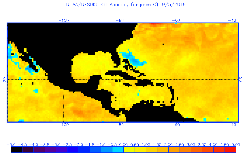
Hurricane Dorian left his mark:
7 likes
-
AutoPenalti
- Category 5
- Posts: 4091
- Age: 29
- Joined: Mon Aug 17, 2015 4:16 pm
- Location: Ft. Lauderdale, Florida
Re: 2019 Indicators: SST'S / Sal / MSLP / Steering / Shear / Instability (See updated graphics at first post)
Welp, unless the next wave crosses this exact spot. That cold spot won’t last long...
3 likes
The posts in this forum are NOT official forecasts and should not be used as such. They are just the opinion of the poster and may or may not be backed by sound meteorological data. They are NOT endorsed by any professional institution or STORM2K. For official information, please refer to products from the NHC and NWS.
Model Runs Cheat Sheet:
GFS (5:30 AM/PM, 11:30 AM/PM)
HWRF, GFDL, UKMET, NAVGEM (6:30-8:00 AM/PM, 12:30-2:00 AM/PM)
ECMWF (1:45 AM/PM)
TCVN is a weighted averaged
-
cycloneye

- Admin

- Posts: 149744
- Age: 69
- Joined: Thu Oct 10, 2002 10:54 am
- Location: San Juan, Puerto Rico
Re: 2019 Indicators: SST'S / Sal / MSLP / Steering / Shear / Instability (See updated graphics at first post)
https://twitter.com/MJVentrice/status/1170315041868066816
https://twitter.com/EricBlake12/status/1170323596562108417
https://twitter.com/EricBlake12/status/1170323596562108417
0 likes
Visit the Caribbean-Central America Weather Thread where you can find at first post web cams,radars
and observations from Caribbean basin members Click Here
and observations from Caribbean basin members Click Here


Re: 2019 Indicators: SST'S / Sal / MSLP / Steering / Shear / Instability (See updated graphics at first post)
CFS not showing much for the next week then gives another good burst of activity lasting into the second week of October, but it shuts the season down entirely after about Oct 15-20. And given how everything not called Dorian has gone, this may turn out to be another 2007-type season where we have two big storms and the rest being weaker struggling storms.
2 likes
The above post is not official and should not be used as such. It is the opinion of the poster and may or may not be backed by sound meteorological data. It is not endorsed by any professional institution or storm2k.org. For official information, please refer to the NHC and NWS products.
Re: 2019 Indicators: SST'S / Sal / MSLP / Steering / Shear / Instability (See updated graphics at first post)
Hammy wrote:CFS not showing much for the next week then gives another good burst of activity lasting into the second week of October, but it shuts the season down entirely after about Oct 15-20. And given how everything not called Dorian has gone, this may turn out to be another 2007-type season where we have two big storms and the rest being weaker struggling storms.
That's a very possible outcome. Should that happen this would be the ultimate "it only takes one" season. We are nearing 9-10 where history says there's a 90% probability of a named storm somewhere in the basin. We're either going to buck history or have a spin up soon. Enjoy the intermission as they tend not to last at this time of year..
0 likes

Re: 2019 Indicators: SST'S / Sal / MSLP / Steering / Shear / Instability (See updated graphics at first post)
We are around 56 ACE. Gabrielle should add a couple tenths more before it’s come. Will need development this week to hit my 60 target for next weekend. I’m close but might have been a few days early. High pressure looks to maintain off the SE Coast for a while.
0 likes
-
NotSparta

- Professional-Met
- Posts: 1677
- Age: 24
- Joined: Fri Aug 18, 2017 8:24 am
- Location: Naples, FL
- Contact:
Re: 2019 Indicators: SST'S / Sal / MSLP / Steering / Shear / Instability (See updated graphics at first post)

1 likes
This post was probably an opinion of mine, and in no way is official. Please refer to http://www.hurricanes.gov for official tropical analysis and advisories.
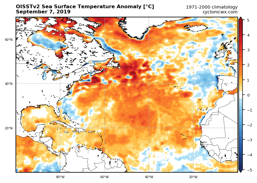
My website, with lots of tropical wx graphics, including satellite and recon: http://cyclonicwx.com
My website, with lots of tropical wx graphics, including satellite and recon: http://cyclonicwx.com
-
CyclonicFury
- Category 5
- Posts: 2038
- Age: 27
- Joined: Sun Jul 02, 2017 12:32 pm
- Location: NC
- Contact:
Re: 2019 Indicators: SST'S / Sal / MSLP / Steering / Shear / Instability (See updated graphics at first post)
The MDR has been largely untapped this season. Overall, the MDR has been quieter than I expected so far. It seems the subsidence and stability is having a major effect. I do wonder though, considering the strong MJO pulse expected to arrive late this month, could we see a late burst of MDR activity?
3 likes
NCSU B.S. in Meteorology Class of 2021. Tropical weather blogger at http://www.cyclonicfury.com. My forecasts and thoughts are NOT official, for official forecasts please consult the National Hurricane Center.
-
Kingarabian

- S2K Supporter
- Posts: 16381
- Joined: Sat Aug 08, 2009 3:06 am
- Location: Honolulu, Hawaii
Re: 2019 Indicators: SST'S / Sal / MSLP / Steering / Shear / Instability (See updated graphics at first post)
EPS weeklies have sort of pushed back that favorable "rising air branch" and don't really show it situating until September 20. It's mostly above average +VP200 anomalies or normal to average for now. Also with the EPAC becoming active, it's possible the Atlantic may go a few weeks without real TC activity as its rare for both basins to be active at the same time.
That being said, EPS long range signal are pointing towards a big October in regards to Atlantic TC activity with a strong rising air branch over the entire Atlantic ocean, while a sinking air branch sets up over the EPAC. My personal forecast numbers for the Atlantic were 14/15 named systems and NOAA's numbers are even higher. If we fail to get a burst of TC activity through the remainder of September, I think my forecast will bust. Unless we have a monster OCtober.
That being said, EPS long range signal are pointing towards a big October in regards to Atlantic TC activity with a strong rising air branch over the entire Atlantic ocean, while a sinking air branch sets up over the EPAC. My personal forecast numbers for the Atlantic were 14/15 named systems and NOAA's numbers are even higher. If we fail to get a burst of TC activity through the remainder of September, I think my forecast will bust. Unless we have a monster OCtober.
2 likes
RIP Kobe Bryant
Re: 2019 Indicators: SST'S / Sal / MSLP / Steering / Shear / Instability (See updated graphics at first post)
Kingarabian wrote:EPS weeklies have sort of pushed back that favorable "rising air branch" and don't really show it situating until September 20. It's mostly above average +VP200 anomalies or normal to average for now. Also with the EPAC becoming active, it's possible the Atlantic may go a few weeks without real TC activity as its rare for both basins to be active at the same time.
That being said, EPS long range signal are pointing towards a big October in regards to Atlantic TC activity with a strong rising air branch over the entire Atlantic ocean, while a sinking air branch sets up over the EPAC. My personal forecast numbers for the Atlantic were 14/15 named systems and NOAA's numbers are even higher. If we fail to get a burst of TC activity through the remainder of September, I think my forecast will bust. Unless we have a monster OCtober.
I'm thinking most of the seasonal forecasts (especially with the hurricane numbers) are going to bust as the MDR is all but completely shut down this year and the CFS has backed off on most stronger activity (while it shows several very short-lived storms through about early to mid October).
Conditions are far less favorable across the basin than I thought a few weeks ago they'd be by now as Dorian and what turned out to be a spate of phantom storms gave the impression that this would actually be a fairly active season. We're now getting into mid-September and suddenly things are shutting down and it's like the Atlantic suddenly reverted back to July and Dorian's intensity seems more like a (very unlucky) fluke rather than anything--while I don't know what the background reason is for the persistent sinking air sitting over the Atlantic most of the season, or the continued high-latitude exiting of the waves, when all is said and done I think Dorian will occupy about half or more of the season's total ACE, as I don't see another 30+ occurring for the remainder of the season without a drastic longer-term improvement in conditions, and soon.
1 likes
The above post is not official and should not be used as such. It is the opinion of the poster and may or may not be backed by sound meteorological data. It is not endorsed by any professional institution or storm2k.org. For official information, please refer to the NHC and NWS products.

Re: 2019 Indicators: SST'S / Sal / MSLP / Steering / Shear / Instability (See updated graphics at first post)
Kingarabian wrote:EPS weeklies have sort of pushed back that favorable "rising air branch" and don't really show it situating until September 20. It's mostly above average +VP200 anomalies or normal to average for now. Also with the EPAC becoming active, it's possible the Atlantic may go a few weeks without real TC activity as its rare for both basins to be active at the same time.
That being said, EPS long range signal are pointing towards a big October in regards to Atlantic TC activity with a strong rising air branch over the entire Atlantic ocean, while a sinking air branch sets up over the EPAC. My personal forecast numbers for the Atlantic were 14/15 named systems and NOAA's numbers are even higher. If we fail to get a burst of TC activity through the remainder of September, I think my forecast will bust. Unless we have a monster OCtober.
Is not unusual for both basins to be active during the Atlantic's peak period during a non-El Nino, September 2004 was a good example, among a few.
3 likes
-
Kingarabian
- S2K Supporter
- Posts: 16381
- Joined: Sat Aug 08, 2009 3:06 am
- Location: Honolulu, Hawaii
Re: 2019 Indicators: SST'S / Sal / MSLP / Steering / Shear / Instability (See updated graphics at first post)
NDG wrote:Kingarabian wrote:EPS weeklies have sort of pushed back that favorable "rising air branch" and don't really show it situating until September 20. It's mostly above average +VP200 anomalies or normal to average for now. Also with the EPAC becoming active, it's possible the Atlantic may go a few weeks without real TC activity as its rare for both basins to be active at the same time.
That being said, EPS long range signal are pointing towards a big October in regards to Atlantic TC activity with a strong rising air branch over the entire Atlantic ocean, while a sinking air branch sets up over the EPAC. My personal forecast numbers for the Atlantic were 14/15 named systems and NOAA's numbers are even higher. If we fail to get a burst of TC activity through the remainder of September, I think my forecast will bust. Unless we have a monster OCtober.
Is not unusual for both basins to be active during the Atlantic's peak period during a non-El Nino, September 2004 was a good example, among a few.
No El Nino or El Nino, 2004 and 2005 were the last years I remember where both basins had activity at the same time. And I'm not simply implying season totals. I mean directly, where if the EPAC has present TCs, the Atlantic is usually quiet and vice versa.
0 likes
RIP Kobe Bryant
Who is online
Users browsing this forum: No registered users and 167 guests