ATL: DORIAN - Post-Tropical - Discussion
Moderator: S2k Moderators
Re: ATL: DORIAN - Hurricane - Discussion
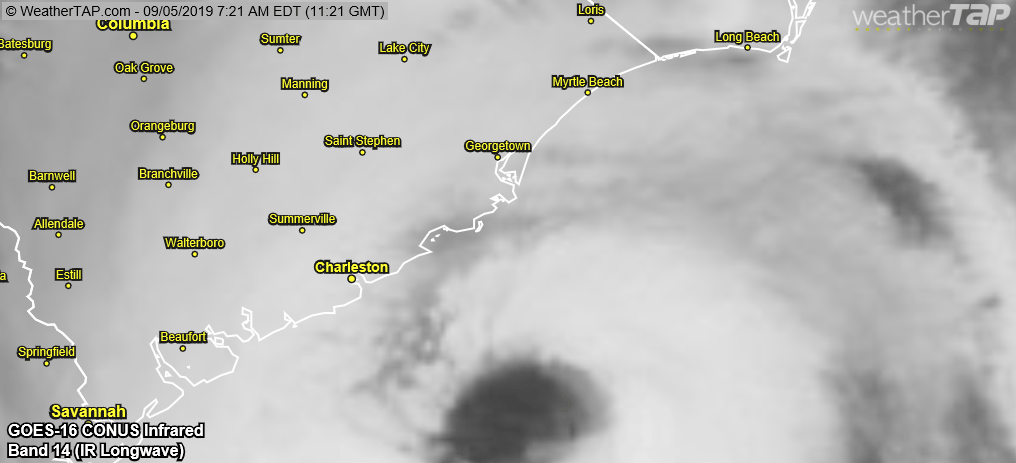
Man that eye is CLOSE! It's nerve wracking just watching this. I've never seen a storm ride the countours of the land so tightly. I know those folks in SC are sweating bullets right now.
Last edited by Vdogg on Thu Sep 05, 2019 8:58 am, edited 1 time in total.
1 likes

Re: ATL: DORIAN - Hurricane - Discussion
Dorian's Wikipedia article says that it had "annular characteristics" while near Grand Bahama. Not sure if I believe that...
https://en.wikipedia.org/wiki/Hurricane_Dorian
https://en.wikipedia.org/wiki/Hurricane_Dorian
3 likes
Igor 2010, Sandy 2012, Fay 2014, Gonzalo 2014, Joaquin 2015, Nicole 2016, Humberto 2019, Imelda 2025
I am only a tropical weather enthusiast. My predictions are not official and may or may not be backed by sound meteorological data. For official information, please refer to the NHC and NWS products.
I am only a tropical weather enthusiast. My predictions are not official and may or may not be backed by sound meteorological data. For official information, please refer to the NHC and NWS products.

Re: ATL: DORIAN - Hurricane - Discussion
It's getting super close to the SC Coast. Luckily a hit of dry air came up from the South on the east side (see IR for that).
https://radar.weather.gov/ridge/radar_l ... 1&loop=yes
https://radar.weather.gov/ridge/radar_l ... 1&loop=yes
0 likes
-
supercane4867
- Category 5

- Posts: 4966
- Joined: Wed Nov 14, 2012 10:43 am
Re: ATL: DORIAN - Hurricane - Discussion
Kazmit wrote:Dorian's Wikipedia article says that it had "annular characteristics" while near Grand Bahama. Not sure if I believe that...
https://en.wikipedia.org/wiki/Hurricane_Dorian
There was no annular characteristics, not even close IMO
3 likes
-
toad strangler

- S2K Supporter

- Posts: 4546
- Joined: Sun Jul 28, 2013 3:09 pm
- Location: Earth
- Contact:
Re: ATL: DORIAN - Hurricane - Discussion
supercane4867 wrote:Wobbling towards the coast?
https://uploads.disquscdn.com/images/71a114b7c9ec03aa307cbd6a20913714cca874050a26dafb1aae79d29b357995.gif
Yeah that's not a friendly eyewall move
2 likes
My Weather Station
https://www.wunderground.com/dashboard/pws/KFLPORTS603
https://www.wunderground.com/dashboard/pws/KFLPORTS603
Re: ATL: DORIAN - Hurricane - Discussion
Kazmit wrote:Dorian's Wikipedia article says that it had "annular characteristics" while near Grand Bahama. Not sure if I believe that...
https://en.wikipedia.org/wiki/Hurricane_Dorian
The source was Advisory 35 Discussion, which said it was a symmetrical cyclone with a 10 nm eye. It didn’t say anything about annular.
3 likes
-
supercane4867
- Category 5
- Posts: 4966
- Joined: Wed Nov 14, 2012 10:43 am
Re: ATL: DORIAN - Hurricane - Discussion
These Dorian-spawned tornadoes look really intense. Some of them could be EF3+ 
https://twitter.com/WeatherNation/status/1169606092445274113
https://twitter.com/WeatherNation/status/1169606092445274113
2 likes

Re: ATL: DORIAN - Hurricane - Discussion
jlauderdal wrote:florida keys peeps dont usually evacuate either, some do, look they have a ton of experience with hurricanes like the outer banks folks, they know what to do and when they really feel like they need to evacuate, they are usually correct on staying or leaving but not always. meanwhile we have people that go right into the eye, chasers and media..im not recommending people stay. I have a 10 foot ladder to get on my roof if needed, i would have evacuated for dorian if it was going to make a direct hit or come into a little south like miami...west palm cat 5, no evacuation...to each his ownplasticup wrote:p1nheadlarry wrote:Not sure if it's been said here before, but just a note on people who live at the Outer Banks: they don't evacuate. It's a mentality similar to citizens of the Conch Republic. If you leave, you're not a local.
Wow, that's really dumb. With a direct hit and a storm surge OBX could be literally unsurvivable.
I get what you're saying, but if my husband (as law enforcement) got hurt (or worse) rescuing someone who chose to ignore mandatory evacuation orders, they would have a vengeful wife to contend with and I'd make Dorian look like a mere puff of wind when I was done with them.
0 likes
I never received my Hogwarts letter, so I'm leaving the Shire and becoming a Sith Lord.
-
southerngreen

- Tropical Storm

- Posts: 141
- Joined: Mon Jul 04, 2005 2:11 am
- Location: Thonotosassa, FL & Old Fort, TN
Re: ATL: DORIAN - Hurricane - Discussion
Vdogg wrote:Man that eye is CLOSE! It's nerve wracking just watching this. I've never seen a storm ride the countouts of the land so tightly. I know those folks in SC are sweating bullets right now.
I know nhc says NNE, but the latest loop just doesn't have much 'East' in it! IMHO
1 likes
Re: ATL: DORIAN - Hurricane - Discussion
supercane4867 wrote:These Dorian-spawned tornadoes look really intense. Some of them could be EF3+
https://twitter.com/WeatherNation/status/1169606092445274113
I don't understand why these tornadoes are so intense. Usually tropical tornadoes are very weak EF0s or EF1s.
0 likes
Re: ATL: DORIAN - Hurricane - Discussion
MB may just barely escape a direct hit. Wilmington will not be so lucky however.
0 likes
-
Aric Dunn
- Category 5
- Posts: 21238
- Age: 43
- Joined: Sun Sep 19, 2004 9:58 pm
- Location: Ready for the Chase.
- Contact:
Re: ATL: DORIAN - Hurricane - Discussion
Looks like it taking a wobble to the coast. probably some land friction tugging on it.
1 likes
Note: If I make a post that is brief. Please refer back to previous posts for the analysis or reasoning. I do not re-write/qoute what my initial post said each time.
If there is nothing before... then just ask
Space & Atmospheric Physicist, Embry-Riddle Aeronautical University,
I believe the sky is falling...
If there is nothing before... then just ask
Space & Atmospheric Physicist, Embry-Riddle Aeronautical University,
I believe the sky is falling...
-
supercane4867
- Category 5
- Posts: 4966
- Joined: Wed Nov 14, 2012 10:43 am
Re: ATL: DORIAN - Hurricane - Discussion
Vdogg wrote:supercane4867 wrote:These Dorian-spawned tornadoes look really intense. Some of them could be EF3+
https://twitter.com/WeatherNation/status/1169606092445274113
I don't understand why these tornadoes are so intense. Usually tropical tornadoes are very weak EF0s or EF1s.
Well it's Dorian after all, normality simply doesn't exist in this storm
Last edited by supercane4867 on Thu Sep 05, 2019 9:02 am, edited 1 time in total.
6 likes
-
supercane4867
- Category 5
- Posts: 4966
- Joined: Wed Nov 14, 2012 10:43 am
Re: ATL: DORIAN - Hurricane - Discussion
Aric Dunn wrote:Looks like it taking a wobble to the coast. probably some land friction tugging on it.
If it doesn't start turning NE it's going to make landfall on SC soon...

Last edited by supercane4867 on Thu Sep 05, 2019 9:02 am, edited 1 time in total.
1 likes
-
p1nheadlarry

- Category 2

- Posts: 672
- Age: 34
- Joined: Wed Jan 29, 2014 2:42 pm
- Location: SR County FL
Re: ATL: DORIAN - Hurricane - Discussion
Vdogg wrote:supercane4867 wrote:These Dorian-spawned tornadoes look really intense. Some of them could be EF3+
https://twitter.com/WeatherNation/status/1169606092445274113
I don't understand why these tornadoes are so intense. Usually tropical tornadoes are very weak EF0s or EF1s.
Veering hodograph, especially above 1 km (see helicity values in middle bottom box). Decent CAPE for an approaching hurricane too.

1 likes
--;->#GoNoles--;->.
-
jlauderdal
- S2K Supporter
- Posts: 7240
- Joined: Wed May 19, 2004 5:46 am
- Location: NE Fort Lauderdale
- Contact:
Re: ATL: DORIAN - Hurricane - Discussion
law enforcement in south Florida wont go into mandatory evacuation areas until the weather subsides, i am totally on board with that policy but they need to stick to it so that people completely understand that there will be no help in a mandatory evacuation zoneEvenstar wrote:jlauderdal wrote:florida keys peeps dont usually evacuate either, some do, look they have a ton of experience with hurricanes like the outer banks folks, they know what to do and when they really feel like they need to evacuate, they are usually correct on staying or leaving but not always. meanwhile we have people that go right into the eye, chasers and media..im not recommending people stay. I have a 10 foot ladder to get on my roof if needed, i would have evacuated for dorian if it was going to make a direct hit or come into a little south like miami...west palm cat 5, no evacuation...to each his ownplasticup wrote:Wow, that's really dumb. With a direct hit and a storm surge OBX could be literally unsurvivable.
I get what you're saying, but if my husband (as law enforcement) got hurt (or worse) rescuing someone who chose to ignore mandatory evacuation orders, they would have a vengeful wife to contend with and I'd make Dorian look like a mere puff of wind when I was done with them.
3 likes
Re: ATL: DORIAN - Hurricane - Discussion
That convection blow up on the east side nasty! I think this might be a historic storm for Willmington.
0 likes

Re: ATL: DORIAN - Hurricane - Discussion
Vdogg wrote:MB may just barely escape a direct hit. Wilmington will not be so lucky however.
Judging by the latest satellite and radar, I'd say Myrtle Beach is about to be hammered. Hopefully those in vulnerable areas along the coast took the evacuation orders seriously!
0 likes
-
1900hurricane

- Category 5
- Posts: 6063
- Age: 34
- Joined: Fri Feb 06, 2015 12:04 pm
- Location: Houston, TX
- Contact:
Re: ATL: DORIAN - Hurricane - Discussion
aperson wrote:Can someone explain to me what physical processes are going on with these efficient looking rain bands that extend perpendicular to the wind field? They even have a noticeable velocity signature
https://cdn.discordapp.com/attachments/485132024949112855/619041658029342720/Screenshot_20190905-002919.png
They also show much higher KDP than surrounding precipitation.
Those are little convective cells embedded within the bands. They're not very tall like showers (although I hesitate to call them that, that's basically what they are), but they're still helping to mix higher winds aloft down into the boundary layer. They also have higher KDPs because of heavier rains within the convective cells.
2 likes
Contract Meteorologist. TAMU & MSST. Fiercely authentic, one of a kind. We are all given free will, so choose a life meant to be lived. We are the Masters of our own Stories.
Opinions expressed are mine alone.
Follow me on Twitter at @1900hurricane : Read blogs at https://1900hurricane.wordpress.com/
Opinions expressed are mine alone.
Follow me on Twitter at @1900hurricane : Read blogs at https://1900hurricane.wordpress.com/
Re: ATL: DORIAN - Hurricane - Discussion
Vdogg wrote:supercane4867 wrote:These Dorian-spawned tornadoes look really intense. Some of them could be EF3+
https://twitter.com/WeatherNation/status/1169606092445274113
I don't understand why these tornadoes are so intense. Usually tropical tornadoes are very weak EF0s or EF1s.
One thing is that there is more CAPE over the Carolina coast and plenty of vertical wind shear.
1 likes
Who is online
Users browsing this forum: No registered users and 50 guests