ATL: DORIAN - Post-Tropical - Discussion

Moderator: S2k Moderators

Message
Author
Smurfwicked
Tropical Storm
Tropical Storm
Posts: 164
Age: 41
Joined: Mon Sep 03, 2007 7:47 pm
Location: SETX

Re: ATL: DORIAN - Hurricane - Discussion

#7241 Postby Smurfwicked » Mon Sep 02, 2019 9:01 am

NDG wrote:Just wow, I guess that's a wrap up on the first EWRC, now a much bigger eye has developed, so cool to see it on radar.

https://i.imgur.com/YlkVnnG.gif


The whole CDO has expanded on IR too. Surprised the wind field hasn't expanded more than it has.
0 likes   

clambite
S2K Supporter
S2K Supporter
Posts: 15
Age: 72
Joined: Tue Aug 23, 2016 9:26 am
Location: Morehead City, NC

Re: ATL: DORIAN - Hurricane - Discussion

#7242 Postby clambite » Mon Sep 02, 2019 9:01 am

SEASON_CANCELED wrote:
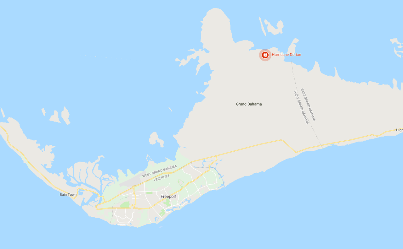
panamatropicwatch wrote:The north side of Grand Bahama has much shallower water. So it probably wouldn't take long for upwelling to occur.

http://tropicwatch.info/grandbahama09022019.png


The thought occurred to me with some of those low lying areas, you could have permanent passes created with all this storm surge...literally island cut into pieces

Being shallow water to begin with...with no cooler water down deep, I wouldn't think upwelling would occur at all.
0 likes   

Raebie
Category 3
Category 3
Posts: 822
Joined: Fri Sep 12, 2003 8:00 pm
Location: Charlotte, NC

Re: ATL: DORIAN - Hurricane - Discussion

#7243 Postby Raebie » Mon Sep 02, 2019 9:02 am

supercane4867 wrote:The ERC seems to be finished based on radar, but you can see another bigger outer eyewall is developing on microwave. The hurricane force wind field is going to be HUGE


Which is bad news for the Florida coast.
0 likes   

AlabamaDave
Tropical Storm
Tropical Storm
Posts: 169
Joined: Wed Aug 11, 2004 6:44 pm

Re: ATL: DORIAN - Hurricane - Discussion

#7244 Postby AlabamaDave » Mon Sep 02, 2019 9:04 am

NDG wrote:Just wow, I guess that's a wrap up on the first EWRC, now a much bigger eye has developed, so cool to see it on radar.


Looks like the eastern parts of Freeport are in the intense parts of the western eyewall now.

Image
0 likes   

User avatar
GCANE
S2K Supporter
S2K Supporter
Posts: 11507
Joined: Mon Oct 22, 2007 8:03 am

Re: ATL: DORIAN - Hurricane - Discussion

#7245 Postby GCANE » Mon Sep 02, 2019 9:06 am

Dorian's warm core extends way up in the troposphere.
Anticyclone is creating a big bubble in the tropopause, way past 100mb.
So, the current mid-layer trough will have a near negligable effect on pulling Dorian north.

Image

Image
1 likes   

User avatar
birdwomn
Category 1
Category 1
Posts: 419
Joined: Wed Aug 11, 2004 8:04 pm
Location: Pinellas County FL

Re: ATL: DORIAN - Hurricane - Discussion

#7246 Postby birdwomn » Mon Sep 02, 2019 9:07 am

Raebie wrote:
supercane4867 wrote:The ERC seems to be finished based on radar, but you can see another bigger outer eyewall is developing on microwave. The hurricane force wind field is going to be HUGE[/quote
Which is bad news for the Florida coast.


It will be very interesting to see how much the center tightens up in this situation. Maybe some good info for ERC predictions in the future?
0 likes   

AutoPenalti
Category 5
Category 5
Posts: 4031
Age: 29
Joined: Mon Aug 17, 2015 4:16 pm
Location: Ft. Lauderdale, Florida

Re: ATL: DORIAN - Hurricane - Discussion

#7247 Postby AutoPenalti » Mon Sep 02, 2019 9:08 am

GCANE wrote:Dorian's warm core extends way up in the troposphere.
Anticyclone is creating a big bubble in the tropopause, way past 100mb.
So, the current mid-layer trough will have a near negligable effect on pulling Dorian north.

https://i.imgur.com/beB2IQC.png

https://i.imgur.com/FbrTkXO.png

Well the trough that’s suppose to pull north hasn’t even arrived yet.
0 likes   
The posts in this forum are NOT official forecasts and should not be used as such. They are just the opinion of the poster and may or may not be backed by sound meteorological data. They are NOT endorsed by any professional institution or STORM2K. For official information, please refer to products from the NHC and NWS.


Model Runs Cheat Sheet:
GFS (5:30 AM/PM, 11:30 AM/PM)
HWRF, GFDL, UKMET, NAVGEM (6:30-8:00 AM/PM, 12:30-2:00 AM/PM)
ECMWF (1:45 AM/PM)

TCVN
is a weighted averaged

Javlin
Category 5
Category 5
Posts: 1621
Age: 64
Joined: Fri Jul 09, 2004 7:58 pm
Location: ms gulf coast

Re: ATL: DORIAN - Hurricane - Discussion

#7248 Postby Javlin » Mon Sep 02, 2019 9:08 am

Some have commented on the possibility if a pass might be made?We have an island about 10 miles out not very big called Ship Island it has what is known to us as Camille's Cut were the island was cut in two!
0 likes   

User avatar
WeatherLovingDoc
S2K Supporter
S2K Supporter
Posts: 453
Joined: Fri Sep 05, 2008 10:08 pm
Location: Washington D.C.

Re: ATL: DORIAN - Hurricane - Discussion

#7249 Postby WeatherLovingDoc » Mon Sep 02, 2019 9:09 am

Came across this just now re: Abaco Bahama

Captain Bamba ⛵️
@bamba_maru
A friend reached out to us from Green Turtle #AbacoIslands at 8:30am via sat device:
"Island gone. Complete destruction. All boats destroyed. We are Safe in Bunker but house blew away. Storm might continue till wednessday."

#Dorian #HurricaneDorian2019 #PrayForTheBahamas
0 likes   

socplay02
Tropical Low
Tropical Low
Posts: 18
Joined: Wed Aug 28, 2019 4:03 pm

Re: ATL: DORIAN - Hurricane - Discussion

#7250 Postby socplay02 » Mon Sep 02, 2019 9:11 am

This place is awesome!!

Not looking for advice, more just some help walking through my thought process and what might be wrong with it.

I live in fort lauderdale and evacuated to Southern Central Georgia (Perry). I went and got supplies last Monday when I saw the ridge on the same Lat as south florida, rented an SUV when it went east of PR (wed), boarded up thurs and took off Friday morning before everyone really went into prep mode Friday (had no traffic, no gas issues). We were ready had the storm not slowed down, largely because I had S2k to give me info to make a rational data driven/supported decision.

Am I crazy to drive to Tampa today, and sneak down the west coast and across 75 back to Ft Lauderdale as the storm goes north? My concern is we will get stuck north of the storm until the end of the week otherwise, especially if it widens and follows some of the models on a cape landfall (Levi explained this really well).

I have a 2.5 year old, my wife is pregnant with our second kid, and I have 2 cats and a dog. My primary goal is to be safe, and want to make sure that 3 nights in a one bedroom Howard Johnson (with the prospect of potentially 3 more nights), isn't clouding my judgment.
4 likes   

Nederlander
S2K Supporter
S2K Supporter
Posts: 1250
Joined: Sat Jul 19, 2008 4:28 pm
Location: Conroe, TX

Re: ATL: DORIAN - Hurricane - Discussion

#7251 Postby Nederlander » Mon Sep 02, 2019 9:12 am

For those with questions on steering and why Dorian has nearly stalled. The first map is 24 hours ago. Notice the ridge to the north providing clockwise flow. The second map is current. The ridge has weakened significantly and Dorian is sandwiched between two ridges with counter flow. But you can see the escape route to the north that it will eventually take.

24 hours ago:
Image

Current:
Image
2 likes   

User avatar
northjaxpro
S2K Supporter
S2K Supporter
Posts: 8900
Joined: Mon Sep 27, 2010 11:21 am
Location: Jacksonville, FL

Re: ATL: DORIAN - Hurricane - Discussion

#7252 Postby northjaxpro » Mon Sep 02, 2019 9:13 am

As it stands currently. NWS is cutrently forecasting a Storm Surge of about 7 feet up and around Brunswick,, especially in relation to the Golden Isles region and Jekyll Island. and 5 feet in around Jacksonville, especially concerming the Saint Johns River and its tributaries.. Also the Intracoastal Waterway basin will be impacted.

This is very crucial here, especially after what we saw here in Jax with Irma in 2017. This is being monitored very closely.
Last edited by northjaxpro on Mon Sep 02, 2019 9:20 am, edited 2 times in total.
0 likes   
NEVER, EVER SAY NEVER in the tropics and weather in general, and most importantly, with life itself!!

________________________________________________________________________________________

Fay 2008 Beryl 2012 Debby 2012 Colin 2016 Hermine 2016 Julia 2016 Matthew 2016 Irma 2017 Dorian 2019

plasticup

Re: ATL: DORIAN - Hurricane - Discussion

#7253 Postby plasticup » Mon Sep 02, 2019 9:14 am

SEASON_CANCELED wrote:
drewschmaltz wrote:
Sanibel wrote:Some people on Grand Bahama have been in the eye for over 7 hours...


I have a fear there may be large loss of life — and everything else. 150+mph winds for that long... how does anything survive? And so much of it washed away. Is there any analog for such a horrible event?


Nothing that I can think of in hurricane history...not that long.

Florida should probably prepare for refugees

Maybe, but the bulk of the population in the Bahamas is in Nassau, which has been largely spared. The country has 400,000 people, and of that 51,000 are on Grand Bahama and 17,000 on Abaco.
1 likes   

User avatar
johngaltfla
Category 5
Category 5
Posts: 2069
Joined: Sun Jul 10, 2005 9:17 pm
Location: Sarasota County, FL
Contact:

Re: ATL: DORIAN - Hurricane - Discussion

#7254 Postby johngaltfla » Mon Sep 02, 2019 9:15 am

GCANE wrote:Dorian's warm core extends way up in the troposphere.
Anticyclone is creating a big bubble in the tropopause, way past 100mb.
So, the current mid-layer trough will have a near negligable effect on pulling Dorian north.

https://i.imgur.com/beB2IQC.png

https://i.imgur.com/FbrTkXO.png


Disturbing if the second ridge builds in and we get a wave of temporary strength from it. :eek:
1 likes   

tolakram
Admin
Admin
Posts: 20012
Age: 62
Joined: Sun Aug 27, 2006 8:23 pm
Location: Florence, KY (name is Mark)

Re: ATL: DORIAN - Hurricane - Discussion

#7255 Postby tolakram » Mon Sep 02, 2019 9:17 am

0 likes   
M a r k
- - - - -
Join us in chat: Storm2K Chatroom Invite. Android and IOS apps also available.

The posts in this forum are NOT official forecasts and should not be used as such. Posts are NOT endorsed by any professional institution or STORM2K.org. For official information and forecasts, please refer to NHC and NWS products.

supercane4867
Category 5
Category 5
Posts: 4966
Joined: Wed Nov 14, 2012 10:43 am

Re: ATL: DORIAN - Hurricane - Discussion

#7256 Postby supercane4867 » Mon Sep 02, 2019 9:19 am

Downtown Freeport will be in the eyewall soon if it keeps crawling west at 1MPH

Image
0 likes   

User avatar
GCANE
S2K Supporter
S2K Supporter
Posts: 11507
Joined: Mon Oct 22, 2007 8:03 am

Re: ATL: DORIAN - Hurricane - Discussion

#7257 Postby GCANE » Mon Sep 02, 2019 9:20 am

AutoPenalti wrote:
GCANE wrote:Dorian's warm core extends way up in the troposphere.
Anticyclone is creating a big bubble in the tropopause, way past 100mb.
So, the current mid-layer trough will have a near negligable effect on pulling Dorian north.

https://i.imgur.com/beB2IQC.png

https://i.imgur.com/FbrTkXO.png

Well the trough that’s suppose to pull north hasn’t even arrived yet.


Looks pretty darn close, enough to have started some sort of tug on it by now

Image

Image
3 likes   

User avatar
SFLcane
S2K Supporter
S2K Supporter
Posts: 10163
Age: 47
Joined: Sat Jun 05, 2010 1:44 pm
Location: Lake Worth Florida

Re: ATL: DORIAN - Hurricane - Discussion

#7258 Postby SFLcane » Mon Sep 02, 2019 9:21 am

Good morning, local Mets here across SFL seem pretty convinced TS winds are likely in Broward. Still only watch in place though and these rain bands have not been very impressive at all.
0 likes   

User avatar
terstorm1012
S2K Supporter
S2K Supporter
Posts: 1314
Age: 43
Joined: Fri Sep 10, 2004 5:36 pm
Location: Millersburg, PA

Re: ATL: DORIAN - Hurricane - Discussion

#7259 Postby terstorm1012 » Mon Sep 02, 2019 9:25 am

has anyone heard from Josh Morgerman and Jim Edds? Sorry to take up room on the thread...but neither have posted since around noon yesterday.
1 likes   
my posts in this forum are NOT official forecast and should not be used as such. They are just my opinion (to which I welcome challenges!) and may or may not be backed by sound meteorological data. They are NOT endorsed by any professional institution or storm2k.org. For official information, please refer to the NHC and NWS products

Raebie
Category 3
Category 3
Posts: 822
Joined: Fri Sep 12, 2003 8:00 pm
Location: Charlotte, NC

Re: ATL: DORIAN - Hurricane - Discussion

#7260 Postby Raebie » Mon Sep 02, 2019 9:26 am

terstorm1012 wrote:has anyone heard from Josh Morgerman and Jim Edds? Sorry to take up room on the thread...but neither have posted since around noon yesterday.


I believe they've heard from Jim but no word from Josh yet.
3 likes   


Return to “2019”

Who is online

Users browsing this forum: No registered users and 21 guests