
Looks like its going stright down the middle of the island.
Likely not though,
Land friction will slow down the LL vorts.
Wonder if this starts to stall here or get a precesion effect.
ATL: DORIAN - Post-Tropical - Discussion
Moderator: S2k Moderators

Re: ATL: DORIAN - Hurricane - Discussion
GCANE wrote:Looks like its going stright down the middle of the island.
Likely not though,
Land friction will slow down the LL vorts.
Wonder if this starts to stall here or get a precesion effect.
Well..it is going S of W...no good either way..
If that continues, then it will go south of freeport and the western part of island get nothing by eyewall
Azimuth, Point 1 to Point 2: 262.08° @ 5.87 mph
0 likes

Re: ATL: DORIAN - Hurricane - Discussion
Is there a site where I can view a satellite of Dorian that's lets say, 12 hours long? to get a better sense of direction.
0 likes

Re: ATL: DORIAN - Hurricane - Discussion
STRiZZY wrote:Is there a site where I can view a satellite of Dorian that's lets say, 12 hours long? to get a better sense of direction.
Like this?
https://weather.cod.edu/satrad/?parms=meso-meso1-13-200-1-25-12&checked=latlon-map&colorbar=undefined
Last edited by birddogsc on Sun Sep 01, 2019 9:05 pm, edited 1 time in total.
3 likes

Re: ATL: DORIAN - Hurricane - Discussion
10:00 PM EDT Sun Sep 1
Location: 26.6°N 77.8°W
Moving: W at 5 mph
Min pressure: 915 mb
Max sustained: 185 mph
Location: 26.6°N 77.8°W
Moving: W at 5 mph
Min pressure: 915 mb
Max sustained: 185 mph
0 likes
Just like Jon Snow..."I know nothing" except what I know, and most of what I know is gathered by the fine people of the NHC
-
1900hurricane

- Category 5

- Posts: 6063
- Age: 34
- Joined: Fri Feb 06, 2015 12:04 pm
- Location: Houston, TX
- Contact:
Re: ATL: DORIAN - Hurricane - Discussion
STRiZZY wrote:Is there a site where I can view a satellite of Dorian that's lets say, 12 hours long? to get a better sense of direction.
Here's the RAMMB page for Dorian. Click archive of the loop you want to view, choose your start and end times, and then hit loop.
0 likes
Contract Meteorologist. TAMU & MSST. Fiercely authentic, one of a kind. We are all given free will, so choose a life meant to be lived. We are the Masters of our own Stories.
Opinions expressed are mine alone.
Follow me on Twitter at @1900hurricane : Read blogs at https://1900hurricane.wordpress.com/
Opinions expressed are mine alone.
Follow me on Twitter at @1900hurricane : Read blogs at https://1900hurricane.wordpress.com/

Re: ATL: DORIAN - Hurricane - Discussion
Texashawk wrote:https://dynaimage.cdn.cnn.com/cnn/digital-images/org/388385e4-6f6c-483a-8915-b786ee4a64b2.jpg
This is the track CNN posted 1.5 hours ago. As you can see, it appears it will be just a *little* off of reality
Well, "this IS CNN" after all.
I don't even think those plot points are accurate. They seem "off."
2 likes
Re: ATL: DORIAN - Hurricane - Discussion
birddogsc wrote:STRiZZY wrote:Is there a site where I can view a satellite of Dorian that's lets say, 12 hours long? to get a better sense of direction.
Like this?
https://weather.cod.edu/satrad/?parms=meso-meso1-13-200-1-25-12&checked=latlon-map&colorbar=undefined
You're the best!
0 likes
-
SapphireSea
- Category 1

- Posts: 430
- Joined: Wed Aug 24, 2005 12:13 pm
- Location: Miami, FL
Re: ATL: DORIAN - Hurricane - Discussion
STRiZZY wrote:MetsIslesNoles wrote:supercane4867 wrote:One take away from Levi's video:
The weaker the storm becomes due to upwelling or eyewall replacement, the higher the chance that it gets steering more from the lower levels, which is from SE-NW as shown in the HWRF runs
His explanation of that was fantastic.
Just goes to show how COMPLICATED these situations are. It's a miracle we can track them at all.
So much to learn, the thought never crossed my mind that the actual height of the storm could change the path due to steering at different levels.
Fascinating stuff Levi!!
Levi's explanation is very good. There indeed is quite a bit to learn, luckily we have come a very long way in tracking the paths of the storm. There is such a vast gap in knowledge in understanding the dynamics to create intensity predictions. Truthfully, I don't know if we will ever get good at that. There is alot of interesting features other than understanding steering layer flows. Someone here I believe was on a paper on Vince/Delta regarding tropopause height anomalies (lower tropopause) allowing warm-core systems to form with water < 25c.
We wont every truly resolve how high the center column goes in the storm I think. We do not sample deeply enough at flight levels. (correct me if I am wrong, not sure about all the instrumentation on AF missions) If anything I believe they also do not fly up further than 150mb.
1 likes
-
lrak

- S2K Supporter

- Posts: 1770
- Age: 59
- Joined: Thu Jun 21, 2007 2:48 pm
- Location: Corpus Christi, TX
Re: ATL: DORIAN - Hurricane - Discussion
0 likes
AKA karl
Also
Personal Forecast Disclaimer:
My posts on this forum are NOT official forecast and should not be used as such. My posts are my basic observations and are definitely not backed by any "well some" meteorological knowledge. For official information, please refer to the NHC and NWS products.
Also
Personal Forecast Disclaimer:
My posts on this forum are NOT official forecast and should not be used as such. My posts are my basic observations and are definitely not backed by any "well some" meteorological knowledge. For official information, please refer to the NHC and NWS products.

Re: ATL: DORIAN - Hurricane - Discussion
Looks like Dorian has wobbled south a little and lost about 7 minutes of latitude which isn't uncommon for a stalling hurricane. Not sure about the EWRC as the inner eyewall still looks intact on IR. There is a buoy station out on the western tip of the island just west of Freeport that will give us some idea of the wind field and perhaps what the Florida east coast barrier islands might experience.
https://www.ndbc.noaa.gov/station_page. ... tion=spgf1
Currently pretty steady winds ~33 knots with gusts to 42 knots.
Only good thing I see is the slower forward speed might be an indicator it is going to stall before the turn to the NW. No opinion about changing the track, although if the wind speed goes over 95 knots at this buoy we may only have 24-36 hours to make final evacs from Florida coastline.
1 likes

Re: ATL: DORIAN - Hurricane - Discussion
CronkPSU wrote:10:00 PM EDT Sun Sep 1
Location: 26.6°N 77.8°W
Moving: W at 5 mph
Min pressure: 915 mb
Max sustained: 185 mph
D is ridiculously strong..185 sustained will level just about everything gust up to 200mph!! I mean seriously..you go outside in 185 and you would die. That’s like a EF4 but for hours not seconds. Possibly a EF 5 gusts sustain 200mph...
1 likes
-
Smurfwicked
- Tropical Storm

- Posts: 164
- Age: 41
- Joined: Mon Sep 03, 2007 7:47 pm
- Location: SETX
Re: ATL: DORIAN - Hurricane - Discussion
johngaltfla wrote:SouthFloridawx wrote:I'm thinking this is the next landfall, shortly.
https://media.discordapp.net/attachments/485132024949112855/617898544833101826/unknown.png
Good call...
http://johngaltfla.com/wordpress/wp-content/uploads/2019/09/090119_2152ET_DORIAN_GRANDBAHAMA.jpg
Those "cays" look small enough to completely wash away or vulnerable enough to be drastically changed by this kind of surge.
0 likes
Re: ATL: DORIAN - Hurricane - Discussion
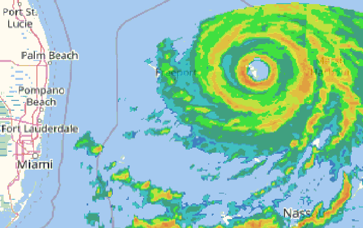
this SFWMD radar has the eye fully visible and has the purple track to assist in serious wobble watching
https://www.sfwmd.gov/weather-radar/cur ... scale-loop
https://www.sfwmd.gov/weather-radar/cur ... scale-loop
2 likes

Re: ATL: DORIAN - Hurricane - Discussion
ROCK wrote:CronkPSU wrote:10:00 PM EDT Sun Sep 1
Location: 26.6°N 77.8°W
Moving: W at 5 mph
Min pressure: 915 mb
Max sustained: 185 mph
D is ridiculously strong..185 sustained will level just about everything gust up to 200mph!! I mean seriously..you go outside in 185 and you would die. That’s like a EF4 but for hours not seconds. Possibly a EF 5 gusts sustain 200mph...
No way I want to get caught in that for sure.
1 likes
-
supercane4867
- Category 5
- Posts: 4966
- Joined: Wed Nov 14, 2012 10:43 am
Re: ATL: DORIAN - Hurricane - Discussion
Concentric eyewall structure is very obvious now on Bahamas radar
8 likes
-
SouthFloridawx

- S2K Supporter
- Posts: 8346
- Age: 47
- Joined: Tue Jul 26, 2005 1:16 am
- Location: Sarasota, FL
- Contact:
Re: ATL: DORIAN - Hurricane - Discussion
Looks like it's on track.
BobHarlem wrote:this SFWMD radar has the eye fully visible and has the purple track to assist in serious wobble watching
https://www.sfwmd.gov/weather-radar/cur ... scale-loop
3 likes
-
EmeraldCoast1

- S2K Supporter
- Posts: 114
- Joined: Tue Sep 30, 2003 10:35 am
- Location: Pensacola, FL
Re: ATL: DORIAN - Hurricane - Discussion
With all this discussion about models, has anyone really highlighted the fact that we DO NOT have a whole lot of Cat.5 historical data to feed the model computers, much less data of storms that are "off the charts" like Dorian???? Seems to me that we are experiencing history here and need to respect that because there isn't a lot of data of storms of this strength, the models can't be relied upon with normal confidence. Just trying to put some perspective on this in terms of our brilliant forecasters and what we should expect from them. This is like a court case setting precedence.
8 likes
-
supercane4867
- Category 5
- Posts: 4966
- Joined: Wed Nov 14, 2012 10:43 am
Who is online
Users browsing this forum: No registered users and 33 guests