That right hook pattern may be bad news for florida later on.
I'm not panicking, checking my supplies tonjght. Making sure i got plenty of canned ham, liquor and batterys
ATL: DORIAN - Models
Moderator: S2k Moderators
-
SEASON_CANCELED

- Category 3

- Posts: 887
- Joined: Mon Jul 06, 2009 5:17 am
- Location: 8 Bit Charlie Sheen
Re: ATL: DORIAN - Models
2 likes
i am a big stupid ugly moron with an ugly face and a big butt and my butt stinks and i like to kiss my own butt
-
AtlanticWind

- S2K Supporter

- Posts: 1898
- Age: 67
- Joined: Sun Aug 08, 2004 9:57 pm
- Location: Plantation,Fla
Re: ATL: DORIAN - Models
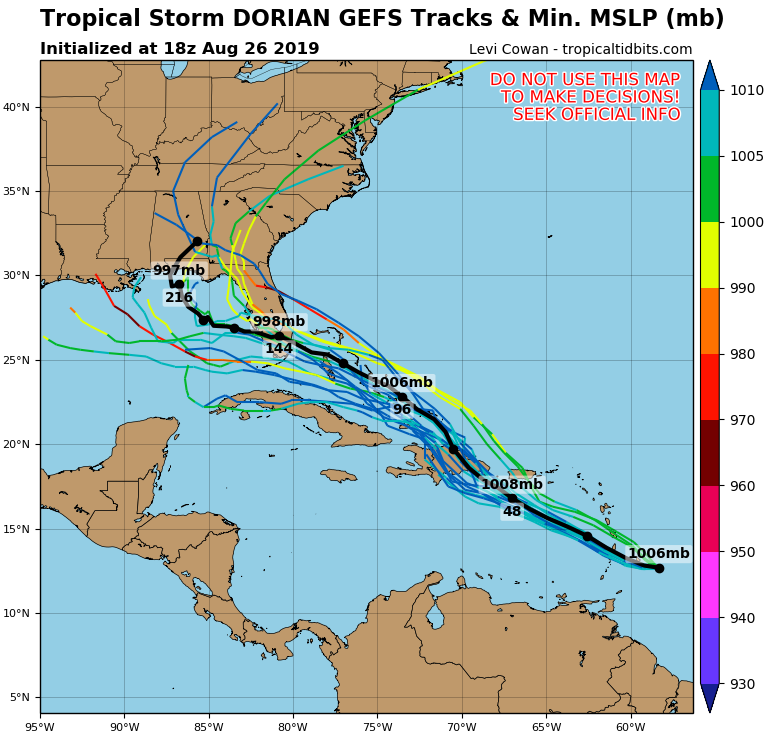
gatorcane wrote:The last three runs of the GFS ensembles have the mean pressure lower each run into Florida and mean track nudging a little south. Latest below:
https://i.postimg.cc/HknrVZRs/05-L-gefs-18z.png
If this system survives the eastern carribean , A South to central Florida threat is real.
4 likes
-
jlauderdal
- S2K Supporter
- Posts: 7240
- Joined: Wed May 19, 2004 5:46 am
- Location: NE Fort Lauderdale
- Contact:
Re: RE: Re: ATL: DORIAN - Models
Liquids, protein and power..that's all you need to get through the mightiest of storms.SEASON_CANCELED wrote:That right hook pattern may be bad news for florida later on.
I'm not panicking, checking my supplies tonjght. Making sure i got plenty of canned ham, liquor and batterys
Sent from my SM-G973U using Tapatalk
2 likes

Re: ATL: DORIAN - Models
northjaxpro wrote:chaser1 wrote:Fascinating. So much rides on whether the GFS is underplaying Dorian's nearer term increase in intensity. It would seem that a far weaker Dorian would suggest a bit more of a westward trek and greater interaction with "the rock". I don't see how that wouldn't wreck the small storm to shreds. On the flip side though, if the majority of other models suggest an increased level of consistency towards a track that would threaten P.R., then the greater question up to that point will be to what degree dry air and/or upper level shear might impact the storm prior to it's approach to Puerto Rico. Hard to imagine Dorian serving up a big threat here, but it seems clear that what ever increased risk to P.R. could well suggest a significant risk to the Bahamas and Florida. Even still, I'm not entirely sold on environmental conditions being that much more conducive once north of the Greater Antilles...... but intensification here (east of the Bahamas) would seem to fall within this season's overall paradigm. Let's put it this way...... Dorian seems to be a far more potential threat to the U.S. then I would have thought 24 hours ago. Let's first see if it'll survive the E. Caribbean shredder. I would be a bit shocked if RI were to really occur during the upcoming 48 hours but small storms are far more capable of such swings. That, and a better maintained intensity however would seem to really imply that environmental conditions overall are quickly becoming less adverse and a real wake up call that the switch were flipped and the lights all on. Will be curious to see how consistent the HWRF is with this one - especially with forecast track.
Good analysis Chaser. I could not have laid this out any better.
Most definitely interesting times ahead this week with Dorian. What a week this could end up being into the holiday weekend!!
Thanks Jax; so then comes the next question whether this event will pose a north/south event strathing Central or East coast Florida all the way up to you. That or, a track that might suggest that the ridge is so firm in place and east/west orientation...... that a T.S. (or Hurricane) ends up dissecting the state and has it re-enter the Gulf to later threaten the Panhandle or areas west from there?
0 likes
Andy D
(For official information, please refer to the NHC and NWS products.)
(For official information, please refer to the NHC and NWS products.)

-
jlauderdal
- S2K Supporter
- Posts: 7240
- Joined: Wed May 19, 2004 5:46 am
- Location: NE Fort Lauderdale
- Contact:
Re: RE: Re: ATL: DORIAN - Models
Tell that to the french quarter.Agua wrote:Alcohol gets pretty old when that's the only activity there is.
6 likes

Re: ATL: DORIAN - Models
Big jump in the number of EPS members that develop Dorian over the Bahamas in the 18z run compared to previous runs...

3 likes
Very useful information on the Dvorak Technique --
https://severe.worldweather.wmo.int/TCF ... kBeven.pdf
https://severe.worldweather.wmo.int/TCF ... kBeven.pdf
Re: RE: Re: ATL: DORIAN - Models
jlauderdal wrote:Tell that to the french quarter.Agua wrote:Alcohol gets pretty old when that's the only activity there is.

1 likes
Andy D
(For official information, please refer to the NHC and NWS products.)
(For official information, please refer to the NHC and NWS products.)
Re: ATL: DORIAN - Models
Cant wait till the 0Z model runs. I'm sure this must have been discussed earlier today but ya gotta admit that it's pretty interesting how there seems so much general modal consensus on track and intensity.......except the GFS which is largely the outlier with regards to strength thus far. What makes this overview even more interesting is that the Legacy GFS seems right in line with the Euro and other models in terms of bring a deeper storm toward Florida. Thus far, the new GFS just doesn't want to buy in yet. Mind you, this is even that much more odd given the increasing GFS ensemble members that seems to increasingly point to a S. Florida landfall threat.
0 likes
Andy D
(For official information, please refer to the NHC and NWS products.)
(For official information, please refer to the NHC and NWS products.)
-
weathermimmi
- Tropical Low

- Posts: 27
- Joined: Wed Aug 24, 2016 9:16 pm
- Location: Destin/FWB Florida
Re: ATL: DORIAN - Models
From the early models and I seeing two landfalls are possible in Florida?
0 likes

Re: ATL: DORIAN - Models
chaser1 wrote:Cant wait till the 0Z model runs. I'm sure this must have been discussed earlier today but ya gotta admit that it's pretty interesting how there seems so much general modal consensus on track and intensity.......except the GFS which is largely the outlier with regards to strength thus far. What makes this overview even more interesting is that the Legacy GFS seems right in line with the Euro and other models in terms of bring a deeper storm toward Florida. Thus far, the new GFS just doesn't want to buy in yet. Mind you, this is even that much more odd given the increasing GFS ensemble members that seems to increasingly point to a S. Florida landfall threat.
That's the question lingering tonight. Is the new GFS sniffing out a more leftward track that suicides into Hispaniola? In years past, agreement between the 'legacy' GFS and Euro was usually spot on. It makes you question which will prove out in the next few days and what that will mean.
1 likes
-
stormlover2013
Re: ATL: DORIAN - Models
Won’t have any consistency till about Thursday
Last edited by stormlover2013 on Mon Aug 26, 2019 9:28 pm, edited 1 time in total.
0 likes
-
ObsessedMiami
- Category 1

- Posts: 432
- Joined: Tue Aug 31, 2004 8:08 pm
- Location: West Kendall, Fl
Re: ATL: DORIAN - Models
SEASON_CANCELED wrote:That right hook pattern may be bad news for florida later on.
I'm not panicking, checking my supplies tonjght. Making sure i got plenty of canned ham, liquor and batterys
I got gas, batteries and vodka. Canned ham sounds good. Let’s hope we don’t need them
1 likes
Re: ATL: DORIAN - Models
stormlover2013 wrote:Won’t have any consistency till about Friday
I'm thinking that by Wednesday with Dorian approaching PR and Hispaniola we're going to have some pretty good consistency. We'll have an idea how Dorian is dealing with the dry air and increasing shear and also how he'll traverse the eye of the needle between PR and Hispaniola. We'll also have a better idea how the ridge will develop to potentially block Dorian and force the WNW movement. I'm seeing Wednesday as the day with answers.
0 likes
-
stormlover2013
Re: ATL: DORIAN - Models
Models haven’t been consistent till about 3-4 days out this year, Thursday or Friday is best bet but leaning towards 00z runs Thursday night, Hispaniola could cause a center relocation i mean still a lot of things have to play out
Last edited by stormlover2013 on Mon Aug 26, 2019 9:33 pm, edited 2 times in total.
0 likes
-
Evil Jeremy

- S2K Supporter
- Posts: 5463
- Age: 32
- Joined: Mon Apr 10, 2006 2:10 pm
- Location: Los Angeles, CA
Re: ATL: DORIAN - Models
I also think we are about 36 hours away from knowing what kind of circulation will be existing on the flip side of Hispaniola, and until then this is just a guessing game.
2 likes
Frances 04 / Jeanne 04 / Katrina 05 / Wilma 05 / Fay 08 / Debby 12 / Andrea 13 / Colin 16 / Hermine 16 / Matthew 16 / Irma 17

Re: ATL: DORIAN - Models
Something to keep in mind, I would question GFS's solution of Dorian running into the middle of Hispaniola and weakening really bad, it has been running left biased with Dorian so far.

9 likes
-
Hurricaneman

- Category 5

- Posts: 7404
- Age: 45
- Joined: Tue Aug 31, 2004 3:24 pm
- Location: central florida
Re: ATL: DORIAN - Models
NDG wrote:Something to keep in mind, I would question GFS's solution of Dorian running into the middle of Hispaniola and weakening really bad, it has been running left biased with Dorian so far.
https://i.imgur.com/mJr1ULl.png
That 15 to 20 miles really makes a difference between death over Hispaniola and being a hurricane of some kind in Florida, the GFS is best case for Florida but that 20 mile could make for the worst case scenario
3 likes
-
beachman80
Re: ATL: DORIAN - Models
Hurricaneman wrote:NDG wrote:Something to keep in mind, I would question GFS's solution of Dorian running into the middle of Hispaniola and weakening really bad, it has been running left biased with Dorian so far.
https://i.imgur.com/mJr1ULl.png
That 15 to 20 miles really makes a difference between death over Hispaniola and being a hurricane of some kind in Florida, the GFS is best case for Florida but that 20 mile could make for the worst case scenario
Agree. If this thing crosses Pico Duarte, Dorian will be dead as a doornail. But 20 miles east and this thing could become a Florida cane.
0 likes
Re: ATL: DORIAN - Models
0z GFS is slightly east of 18z at 42 hours out, may miss Hispaniola this time.
0 likes
Who is online
Users browsing this forum: No registered users and 55 guests