

ATL: DORIAN - Models
Moderator: S2k Moderators
Re: ATL: DORIAN - Models
For the new GFS. Not sure if we can still get the legacy ensembles.
Last edited by MrJames on Mon Aug 26, 2019 7:11 pm, edited 1 time in total.
0 likes
-
AtlanticWind

- S2K Supporter

- Posts: 1898
- Age: 67
- Joined: Sun Aug 08, 2004 9:57 pm
- Location: Plantation,Fla
Re: ATL: DORIAN - Models
artist wrote:BobHarlem wrote:18z HMON and 18z HWRF both go poof. And dissipate the system. HWRF before it even reaches Hispaniola.
And the plane is already finding lower pressure before getting to the core than both of them show.
NHC east pressure is 1007 at 8pm
0 likes

Re: ATL: DORIAN - Models
AtlanticWind wrote:artist wrote:BobHarlem wrote:18z HMON and 18z HWRF both go poof. And dissipate the system. HWRF before it even reaches Hispaniola.
And the plane is already finding lower pressure before getting to the core than both of them show.
NHC east pressure is 1007 at 8pm
But the hwrf and hmon showed pressure of 1010 and 1012 there. Recon actually did find 1005 even though they went with 1007.
0 likes
-
SouthFLTropics

- Category 5

- Posts: 4258
- Age: 50
- Joined: Thu Aug 14, 2003 8:04 am
- Location: Port St. Lucie, Florida
Re: ATL: DORIAN - Models
18z HWRF finally puts Dorian back together again by the time it reaches the NW Bahamas at Hour 126, albeit weak.
0 likes
Fourth Generation Florida Native
Personal Storm History: David 79, Andrew 92, Erin 95, Floyd 99, Irene 99, Frances 04, Jeanne 04, Wilma 05, Matthew 16, Irma 17, Ian 22, Nicole 22, Milton 24
Personal Storm History: David 79, Andrew 92, Erin 95, Floyd 99, Irene 99, Frances 04, Jeanne 04, Wilma 05, Matthew 16, Irma 17, Ian 22, Nicole 22, Milton 24
-
AtlanticWind
- S2K Supporter
- Posts: 1898
- Age: 67
- Joined: Sun Aug 08, 2004 9:57 pm
- Location: Plantation,Fla
Re: ATL: DORIAN - Models
artist wrote:AtlanticWind wrote:artist wrote:And the plane is already finding lower pressure before getting to the core than both of them show.
NHC east pressure is 1007 at 8pm
But the hwrf and hmon showed pressure of 1010 and 1012 there. Recon actually did find 1005 even though they went with 1007.
Hwrf pressure at initialization was 1000 mb
0 likes
-
jlauderdal
- S2K Supporter
- Posts: 7240
- Joined: Wed May 19, 2004 5:46 am
- Location: NE Fort Lauderdale
- Contact:
Re: RE: Re: ATL: DORIAN - Models
You can focus on the center line here, they don't want the general public too for preparation purposes. Even if it splits the passage, inflow disruption can occur as it's making its journey away from the passage, the mountains can choke off the flow if the speed and trajectory line up. However, once it's made its run from Hispaniola then the Bahamas does nada to knock it down. It's a very dangerous setup next weekend into next week.Nederlander wrote:First, a disclaimer: I understand that you shouldn’t focus on the center of the NHC cone.
That being said, IF Dorian travels the center of the NHC come, then land interaction would be pretty minimal as it splits PR and Hisp. Therefore, the weakening to TS and staying there is curious. Maybe just a conservative estimate until there’s a better idea of how land interaction will affect Dorian?
Sent from my KFKAWI using Tapatalk
3 likes
Re: ATL: DORIAN - Models
. Then I must have misread itAtlanticWind wrote:artist wrote:AtlanticWind wrote:NHC east pressure is 1007 at 8pm
But the hwrf and hmon showed pressure of 1010 and 1012 there. Recon actually did find 1005 even though they went with 1007.
Hwrf pressure at initialization was 1000 mb
Actually, we were both wrong. It was 1008

0 likes

-
AtlanticWind
- S2K Supporter
- Posts: 1898
- Age: 67
- Joined: Sun Aug 08, 2004 9:57 pm
- Location: Plantation,Fla
Re: ATL: DORIAN - Models
artist wrote:. Then I must have misread itAtlanticWind wrote:artist wrote:But the hwrf and hmon showed pressure of 1010 and 1012 there. Recon actually did find 1005 even though they went with 1007.
Hwrf pressure at initialization was 1000 mb
Actually, we were both wrong. It was 1008
https://i.imgur.com/bnK9N6W.jpg
https://www.tropicaltidbits.com/analysi ... 82618&fh=3
Check link
0 likes
-
TheProfessor

- Professional-Met

- Posts: 3506
- Age: 29
- Joined: Tue Dec 03, 2013 10:56 am
- Location: Wichita, Kansas
Re: ATL: DORIAN - Models
SFLcane wrote:18z euro anyone?
18z Euro has this brush up against the northeastern parts of the Dominican Republic and then moves it into the eastern Bahamas as a 995mb tropical storm. Looks to be a bit stronger at 84 hours than it was at 90 hours on the 12z run.
2 likes
An alumnus of The Ohio State University.
Your local National Weather Service office is your best source for weather information.
Your local National Weather Service office is your best source for weather information.
-
TheStormExpert
Re: ATL: DORIAN - Models
TheProfessor wrote:SFLcane wrote:18z euro anyone?
18z Euro has this brush up against the northeastern parts of the Dominican Republic and then moves it into the eastern Bahamas as a 995mb tropical storm. Looks to be a bit stronger at 84 hours than it was at 90 hours on the 12z run.
What is the 18z Euro initialization pressure?
0 likes
-
Kingarabian

- S2K Supporter
- Posts: 16279
- Joined: Sat Aug 08, 2009 3:06 am
- Location: Honolulu, Hawaii
Re: ATL: DORIAN - Models
TheStormExpert wrote:TheProfessor wrote:SFLcane wrote:18z euro anyone?
18z Euro has this brush up against the northeastern parts of the Dominican Republic and then moves it into the eastern Bahamas as a 995mb tropical storm. Looks to be a bit stronger at 84 hours than it was at 90 hours on the 12z run.
What is the 18z Euro initialization pressure?
Near 1005mb.
0 likes
RIP Kobe Bryant


Re: ATL: DORIAN - Models
TheStormExpert wrote:TheProfessor wrote:SFLcane wrote:18z euro anyone?
18z Euro has this brush up against the northeastern parts of the Dominican Republic and then moves it into the eastern Bahamas as a 995mb tropical storm. Looks to be a bit stronger at 84 hours than it was at 90 hours on the 12z run.
What is the 18z Euro initialization pressure?
Didn’t know there WAS and 18z euro.
12z and 0z only right?
0 likes
-
TheProfessor
- Professional-Met
- Posts: 3506
- Age: 29
- Joined: Tue Dec 03, 2013 10:56 am
- Location: Wichita, Kansas
Re: ATL: DORIAN - Models
MetroMike wrote:TheStormExpert wrote:TheProfessor wrote:
18z Euro has this brush up against the northeastern parts of the Dominican Republic and then moves it into the eastern Bahamas as a 995mb tropical storm. Looks to be a bit stronger at 84 hours than it was at 90 hours on the 12z run.
What is the 18z Euro initialization pressure?
Didn’t know there WAS and 18z euro.
12z and 0z only right?
I have yet to find an 18z euro that's free, but there definitely is one.
3 likes
An alumnus of The Ohio State University.
Your local National Weather Service office is your best source for weather information.
Your local National Weather Service office is your best source for weather information.
-
Kingarabian
- S2K Supporter
- Posts: 16279
- Joined: Sat Aug 08, 2009 3:06 am
- Location: Honolulu, Hawaii
Re: ATL: DORIAN - Models
MetroMike wrote:TheStormExpert wrote:TheProfessor wrote:
18z Euro has this brush up against the northeastern parts of the Dominican Republic and then moves it into the eastern Bahamas as a 995mb tropical storm. Looks to be a bit stronger at 84 hours than it was at 90 hours on the 12z run.
What is the 18z Euro initialization pressure?
Didn’t know there WAS and 18z euro.
12z and 0z only right?
You can sign up @ www.Weathermodels.com or Weather.us to see the 06z and 18z Euro runs with some great parameters.
18z Euro is the strongest run yet from the model in regards to Dorian:

0 likes
RIP Kobe Bryant
Re: ATL: DORIAN - Models
AtlanticWind wrote:artist wrote:. Then I must have misread itAtlanticWind wrote:Hwrf pressure at initialization was 1000 mb
Actually, we were both wrong. It was 1008
https://i.imgur.com/bnK9N6W.jpg
https://www.tropicaltidbits.com/analysi ... 82618&fh=3
Check link
Differing links!
https://www.weathernerds.org/models/hwrf04.html
0 likes
-
islandgirl45
- Tropical Low

- Posts: 22
- Joined: Tue Oct 20, 2009 10:51 pm
Re: ATL: DORIAN - Models
When will tonight's recon data be incorporated into the models? Will it make it for the next Euro?
Last edited by islandgirl45 on Mon Aug 26, 2019 8:08 pm, edited 1 time in total.
0 likes
Re: ATL: DORIAN - Models
islandgirl45 wrote:When will tonight's recon data be incorporated into the models?
Either 6z or 12z tomorrow.
0 likes
-
gatorcane

- S2K Supporter
- Posts: 23703
- Age: 47
- Joined: Sun Mar 13, 2005 3:54 pm
- Location: Boca Raton, FL
Re: ATL: DORIAN - Models
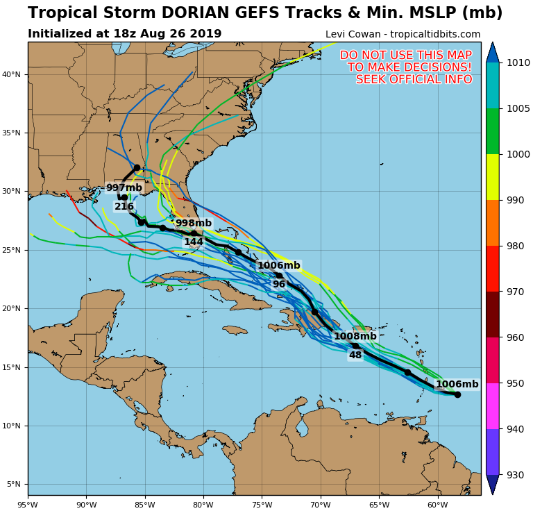
The last three runs of the GFS ensembles have the mean pressure lower each run into Florida and mean track nudging a little south. Latest below:
0 likes
Who is online
Users browsing this forum: No registered users and 55 guests