ATL: DORIAN - Post-Tropical - Discussion
Moderator: S2k Moderators
-
HurricaneAndre2008

- Category 1

- Posts: 356
- Age: 28
- Joined: Wed Jul 31, 2019 9:51 pm
- Contact:
Re: ATL: DORIAN - Tropical Storm - Discussion
Up to 50kts next advisory.
1 likes
Cindy(2005), Katrina(2005), Rita(2005), Erin(2007), Isaac(2012)
-
USTropics
- Professional-Met

- Posts: 2741
- Joined: Sun Aug 12, 2007 3:45 am
- Location: Florida State University
Re: ATL: DORIAN - Tropical Storm - Discussion
HurricaneAndre2008 wrote:Up to 50kts next advisory.
AL, 05, 2019082606, , BEST, 0, 118N, 558W, 50, 1002, TS, 50, NEQ, 20, 0, 0, 0, 1012, 100, 10, 0, 0, L, 0, , 0, 0, DORIAN, M, 0, , 0, 0, 0, 0, genesis-num, 013
It'll be interesting this morning to see how Dorian performs, given the past few mornings he's had his best convective bursts and will be entering increasingly warmer waters in the next few hours:

2 likes
-
HurricaneAndre2008
- Category 1
- Posts: 356
- Age: 28
- Joined: Wed Jul 31, 2019 9:51 pm
- Contact:
Re: ATL: DORIAN - Tropical Storm - Discussion
USTropics wrote:HurricaneAndre2008 wrote:Up to 50kts next advisory.AL, 05, 2019082606, , BEST, 0, 118N, 558W, 50, 1002, TS, 50, NEQ, 20, 0, 0, 0, 1012, 100, 10, 0, 0, L, 0, , 0, 0, DORIAN, M, 0, , 0, 0, 0, 0, genesis-num, 013
It'll be interesting this morning to see how Dorian performs, given the past few mornings he's had his best convective bursts and will be entering increasingly warmer waters in the next few hours:
https://i.imgur.com/NjbxeJe.png
Maybe a hurricane later today.
0 likes
Cindy(2005), Katrina(2005), Rita(2005), Erin(2007), Isaac(2012)
-
Aric Dunn
- Category 5

- Posts: 21238
- Age: 43
- Joined: Sun Sep 19, 2004 9:58 pm
- Location: Ready for the Chase.
- Contact:
Re: ATL: DORIAN - Tropical Storm - Discussion
Now its cooking. Curved banding on north and south side. Whole column is rotating...
4 likes
Note: If I make a post that is brief. Please refer back to previous posts for the analysis or reasoning. I do not re-write/qoute what my initial post said each time.
If there is nothing before... then just ask
Space & Atmospheric Physicist, Embry-Riddle Aeronautical University,
I believe the sky is falling...
If there is nothing before... then just ask
Space & Atmospheric Physicist, Embry-Riddle Aeronautical University,
I believe the sky is falling...
-
Nancy Smar

- Category 5
- Posts: 1081
- Age: 25
- Joined: Wed Aug 16, 2017 10:03 pm
Re: ATL: DORIAN - Tropical Storm - Discussion
AL, 05, 2019082606, 03, OFCL, 0, 118N, 558W, 50, 0, TS, 34, NEQ, 40, 30, 20, 40, 0, 0, 0, 60, 0, , 0, , 0, 0, , , 12, NEQ, 60, 15, 0, 30,
AL, 05, 2019082606, 03, OFCL, 0, 118N, 558W, 50, 0, TS, 50, NEQ, 20, 0, 0, 0, 0, 0, 0, 60, 0, , 0, , 0, 0, , , 12, NEQ, 60, 15, 0, 30,
AL, 05, 2019082606, 03, OFCL, 12, 124N, 582W, 50, 0, TS, 34, NEQ, 40, 30, 20, 40, 0, 0, 0, 60, 0,
AL, 05, 2019082606, 03, OFCL, 12, 124N, 582W, 50, 0, TS, 50, NEQ, 20, 0, 0, 20, 0, 0, 0, 60, 0,
AL, 05, 2019082606, 03, OFCL, 24, 132N, 603W, 55, 0, TS, 34, NEQ, 40, 40, 20, 40, 0, 0, 0, 65, 0,
AL, 05, 2019082606, 03, OFCL, 24, 132N, 603W, 55, 0, TS, 50, NEQ, 20, 0, 0, 20, 0, 0, 0, 65, 0,
AL, 05, 2019082606, 03, OFCL, 36, 144N, 624W, 55, 0, TS, 34, NEQ, 40, 40, 20, 40, 0, 0, 0, 65, 0,
AL, 05, 2019082606, 03, OFCL, 36, 144N, 624W, 55, 0, TS, 50, NEQ, 20, 0, 0, 20, 0, 0, 0, 65, 0,
AL, 05, 2019082606, 03, OFCL, 48, 155N, 645W, 60, 0, TS, 34, NEQ, 50, 40, 30, 50, 0, 0, 0, 75, 0,
AL, 05, 2019082606, 03, OFCL, 48, 155N, 645W, 60, 0, TS, 50, NEQ, 20, 20, 10, 20, 0, 0, 0, 75, 0,
AL, 05, 2019082606, 03, OFCL, 72, 180N, 684W, 65, 0, HU, 34, NEQ, 50, 40, 30, 50, 0, 0, 0, 80, 0,
AL, 05, 2019082606, 03, OFCL, 72, 180N, 684W, 65, 0, HU, 50, NEQ, 30, 20, 10, 20, 0, 0, 0, 80, 0,
AL, 05, 2019082606, 03, OFCL, 96, 208N, 716W, 30, 0, TD, 34, NEQ, 0, 0, 0, 0, 0, 0, 0, 40, 0,
AL, 05, 2019082606, 03, OFCL, 120, 230N, 750W, 30, 0, TD, 34, NEQ, 0, 0, 0, 0, 0, 0, 0, 40, 0,
0 likes
-
hurricaneCW
- Category 5
- Posts: 1799
- Joined: Wed Mar 03, 2010 6:20 am
- Location: Toms River, NJ
Re: ATL: DORIAN - Tropical Storm - Discussion
It's a small system, it's late August so not all that surprising that it's getting going.
He could be a sneaky threat down the line.
He could be a sneaky threat down the line.
0 likes
-
USTropics
- Professional-Met
- Posts: 2741
- Joined: Sun Aug 12, 2007 3:45 am
- Location: Florida State University
Re: ATL: DORIAN - Tropical Storm - Discussion
Aric Dunn wrote:Now its cooking. Curved banding on north and south side. Whole column is rotating...
Nice burst right over the center, CDO is improving:

1 likes

Re: ATL: DORIAN - Tropical Storm - Discussion
The dual banding looks sick right now. Just needs an eye to pop out.

2 likes
Very useful information on the Dvorak Technique --
https://severe.worldweather.wmo.int/TCF ... kBeven.pdf
https://severe.worldweather.wmo.int/TCF ... kBeven.pdf
-
Aric Dunn
- Category 5
- Posts: 21238
- Age: 43
- Joined: Sun Sep 19, 2004 9:58 pm
- Location: Ready for the Chase.
- Contact:
Re: ATL: DORIAN - Tropical Storm - Discussion
With the teo large curved bnads it looks like it has effectively cut itself off from the dry air.
It is looking extremely well right now. Recon is probably going to find a hurricane. Or st least very close
It is looking extremely well right now. Recon is probably going to find a hurricane. Or st least very close
4 likes
Note: If I make a post that is brief. Please refer back to previous posts for the analysis or reasoning. I do not re-write/qoute what my initial post said each time.
If there is nothing before... then just ask
Space & Atmospheric Physicist, Embry-Riddle Aeronautical University,
I believe the sky is falling...
If there is nothing before... then just ask
Space & Atmospheric Physicist, Embry-Riddle Aeronautical University,
I believe the sky is falling...


-
Kingarabian

- S2K Supporter

- Posts: 16379
- Joined: Sat Aug 08, 2009 3:06 am
- Location: Honolulu, Hawaii
Re: ATL: DORIAN - Tropical Storm - Discussion
Aric Dunn wrote:With the teo large curved bnads it looks like it has effectively cut itself off from the dry air.
It is looking extremely well right now. Recon is probably going to find a hurricane. Or st least very close
It certainly looks much better right now. Nice structure. Satellite derived estimates are still near T3.5 and will remain such until it can develop colder cloud tops or an eye like feature becomes evident.
2 likes
RIP Kobe Bryant
-
Kingarabian
- S2K Supporter
- Posts: 16379
- Joined: Sat Aug 08, 2009 3:06 am
- Location: Honolulu, Hawaii
Re: ATL: DORIAN - Tropical Storm - Discussion
Here's the latest microwave image:

Core looks established in all quads except the south.
Core looks established in all quads except the south.
2 likes
RIP Kobe Bryant
-
Aric Dunn
- Category 5
- Posts: 21238
- Age: 43
- Joined: Sun Sep 19, 2004 9:58 pm
- Location: Ready for the Chase.
- Contact:
Re: ATL: DORIAN - Tropical Storm - Discussion
I cant believe recon does not fly for another 12 hours.. seems silly.
6 likes
Note: If I make a post that is brief. Please refer back to previous posts for the analysis or reasoning. I do not re-write/qoute what my initial post said each time.
If there is nothing before... then just ask
Space & Atmospheric Physicist, Embry-Riddle Aeronautical University,
I believe the sky is falling...
If there is nothing before... then just ask
Space & Atmospheric Physicist, Embry-Riddle Aeronautical University,
I believe the sky is falling...

Re: ATL: DORIAN - Tropical Storm - Discussion
0 likes
The above post is not official and should not be used as such. It is the opinion of the poster and may or may not be backed by sound meteorological data. It is not endorsed by any professional institution or storm2k.org. For official information, please refer to the NHC and NWS products.
-
Kingarabian
- S2K Supporter
- Posts: 16379
- Joined: Sat Aug 08, 2009 3:06 am
- Location: Honolulu, Hawaii
Re: ATL: DORIAN - Tropical Storm - Discussion
Hammy wrote::uarrow: Center looks a bit 'exposed' there and away from the main convection, there appears to be a bit of mid-level shear working it's way in from the south.

2 likes
RIP Kobe Bryant
Re: ATL: DORIAN - Tropical Storm - Discussion
Kingarabian wrote:Here's the latest microwave image:
https://i.imgur.com/OsoWTDO.jpg
Core looks established in all quads except the south.
Couple of towers just starting to go off on the south side right now
0 likes
Very useful information on the Dvorak Technique --
https://severe.worldweather.wmo.int/TCF ... kBeven.pdf
https://severe.worldweather.wmo.int/TCF ... kBeven.pdf
Re: ATL: DORIAN - Tropical Storm - Discussion
I think the reason Dorian is ramping is due to the fact that high TPW air was advected into the system from a very warm SST current off S America.
Dorian is now past it.
Current location is green circle on Earth Nullschool image.
Tons of dry air ahead, even up to the higher levels.


Dorian is now past it.
Current location is green circle on Earth Nullschool image.
Tons of dry air ahead, even up to the higher levels.
1 likes

Re: ATL: DORIAN - Tropical Storm - Discussion
From the 5am NHC Discussion:
It should be noted that the GFS and ECMWF have been very consistent in showing Dorian dissipating over the Caribbean Sea.
Did they just ignore the 0z Euro? I guess they are waiting on more consistency, but the latest Euro has anything but dissipation.
It should be noted that the GFS and ECMWF have been very consistent in showing Dorian dissipating over the Caribbean Sea.
Did they just ignore the 0z Euro? I guess they are waiting on more consistency, but the latest Euro has anything but dissipation.
1 likes
-
Tailspin
-
Aric Dunn
- Category 5
- Posts: 21238
- Age: 43
- Joined: Sun Sep 19, 2004 9:58 pm
- Location: Ready for the Chase.
- Contact:
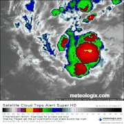
Re: ATL: DORIAN - Tropical Storm - Discussion
No delay in convection this time. Biggest thing to note is the full curved band outlined by the overshooting tops. That's the first real sign of it being close to hurricane. Impressive actually
0 likes
Note: If I make a post that is brief. Please refer back to previous posts for the analysis or reasoning. I do not re-write/qoute what my initial post said each time.
If there is nothing before... then just ask
Space & Atmospheric Physicist, Embry-Riddle Aeronautical University,
I believe the sky is falling...
If there is nothing before... then just ask
Space & Atmospheric Physicist, Embry-Riddle Aeronautical University,
I believe the sky is falling...
Who is online
Users browsing this forum: No registered users and 47 guests