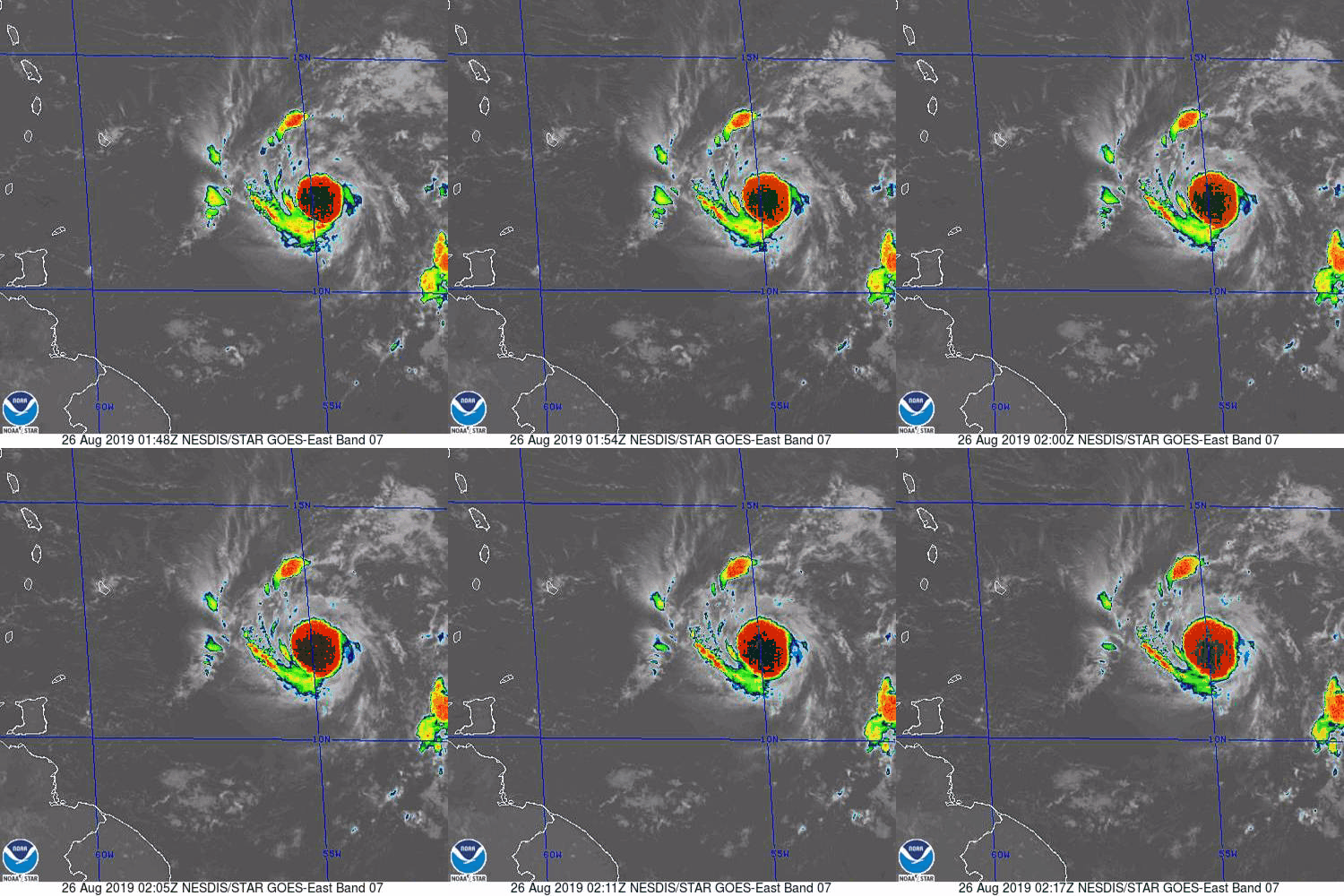
ATL: DORIAN - Post-Tropical - Discussion

Moderator: S2k Moderators

Message
Author
User avatar
HDGator
S2K Supporter
S2K Supporter
Posts: 242
Joined: Fri Sep 17, 2004 3:03 pm
Location: Lewisville, NC

Re: ATL: DORIAN - Tropical Storm - Discussion

#481 Postby HDGator » Sun Aug 25, 2019 8:55 pm

Blown Away wrote:https://i.imgur.com/W6ln85f.jpg

I attempted to draw the 00z TVCN Consensus line (NHC seems to follow this consensus line closely) compared to the 5pm NHC line... They flattened the line from 11am to 5pm, but didn't move it much north over Hispaniola, so I think at 11pm we will see a track inched N with less Hispaniola interaction and will that change intensity forecast???

Thanks for the overlay. If Dorian battles through the dry air, those two paths are the crux of the question we're facing. One takes it through a shredder and leaves next to nothing on the other side of the mountains of Hispaniola while the TVCN takes the 'magic route' that presents the worst danger for CONUS with those of us in South Florida in the crosshairs.

I can't see the NHC doing much to shift the forecast at 11pm until the GFS and ECMWF start to get on board with a survival scenario for Dorian in the Eastern Caribbean. At this point, I'm thinking it's still a small probability worst case scenario. I can hope, but you can tell from my post count and past posts that I'm only here when the bad scenario for South Florida is possibly in play.
3 likes   

Aric Dunn
Category 5
Category 5
Posts: 21238
Age: 42
Joined: Sun Sep 19, 2004 9:58 pm
Location: Ready for the Chase.
Contact:

Re: ATL: DORIAN - Tropical Storm - Discussion

#482 Postby Aric Dunn » Sun Aug 25, 2019 8:55 pm

Evil Jeremy wrote:If the South/East Florida scenario were to play out, impact looks to be next Sunday, a week from today. If I get off work tomorrow and models are holding steady, I'm getting my basic supplies. Not getting caught off guard. Hopefully not, but if there were to be madness in anticipation of a Hurricane here, it would be kicking in around Wednesday.


regardless of strength. an out sea option is very low.
4 likes   
Note: If I make a post that is brief. Please refer back to previous posts for the analysis or reasoning. I do not re-write/qoute what my initial post said each time.
If there is nothing before... then just ask :)

Space & Atmospheric Physicist, Embry-Riddle Aeronautical University,
I believe the sky is falling...

User avatar
toad strangler
S2K Supporter
S2K Supporter
Posts: 4543
Joined: Sun Jul 28, 2013 3:09 pm
Location: Earth
Contact:

Re: ATL: DORIAN - Tropical Storm - Discussion

#483 Postby toad strangler » Sun Aug 25, 2019 9:00 pm

Evil Jeremy wrote:If the South/East Florida scenario were to play out, impact looks to be next Sunday, a week from today. If I get off work tomorrow and models are holding steady, I'm getting my basic supplies. Not getting caught off guard. Hopefully not, but if there were to be madness in anticipation of a Hurricane here, it would be kicking in around Wednesday.


I have everything done every June. All I have to do is fill the gas cans. Looking for them to stay empty.
0 likes   

User avatar
Evil Jeremy
S2K Supporter
S2K Supporter
Posts: 5463
Age: 32
Joined: Mon Apr 10, 2006 2:10 pm
Location: Los Angeles, CA

Re: ATL: DORIAN - Tropical Storm - Discussion

#484 Postby Evil Jeremy » Sun Aug 25, 2019 9:00 pm

Aric Dunn wrote:
Evil Jeremy wrote:If the South/East Florida scenario were to play out, impact looks to be next Sunday, a week from today. If I get off work tomorrow and models are holding steady, I'm getting my basic supplies. Not getting caught off guard. Hopefully not, but if there were to be madness in anticipation of a Hurricane here, it would be kicking in around Wednesday.


regardless of strength. an out sea option is very low.


Dissipation via shear and/or the Hispaniola Meat Grinder is still on the table though. Maybe it will pull a Chris 2006 and vanish into thin air.
3 likes   
Frances 04 / Jeanne 04 / Katrina 05 / Wilma 05 / Fay 08 / Debby 12 / Andrea 13 / Colin 16 / Hermine 16 / Matthew 16 / Irma 17

User avatar
Highteeld
Category 5
Category 5
Posts: 2139
Age: 41
Joined: Tue Jan 30, 2018 9:10 pm
Location: Chicago

Re: ATL: DORIAN - Tropical Storm - Discussion

#485 Postby Highteeld » Sun Aug 25, 2019 9:01 pm

Image
1 likes   
Very useful information on the Dvorak Technique --

https://severe.worldweather.wmo.int/TCF ... kBeven.pdf

User avatar
Bostonriff
Tropical Low
Tropical Low
Posts: 33
Joined: Tue Sep 05, 2017 9:23 pm

Re: ATL: DORIAN - Tropical Storm - Discussion

#486 Postby Bostonriff » Sun Aug 25, 2019 9:02 pm

Blown Away wrote: https://i.imgur.com/1RDuyZR.jpg
Historical Aug/Sept tracks within 75 miles of the NHC 5 day point for Dorian... GOM is a real possibility after raking the entire Caribbean...

Jamaica seems to have a charmed life....

(If I recall correctly, it hasn't had a cat-3 hit since Gilbert in 1988, and has never been hit by a cat-4 or cat-5, which is kinda bonkers when you think about where that not-exactly-small island is sitting.)
2 likes   
Do not bet the ranch based on any non-official forecasts that may appear in the post above no matter how strongly argued they may be, because the fates are capricious and have Murphy's Law on speed-dial.

User avatar
Nancy Smar
Category 5
Category 5
Posts: 1081
Age: 24
Joined: Wed Aug 16, 2017 10:03 pm

Re: ATL: DORIAN - Tropical Storm - Discussion

#487 Postby Nancy Smar » Sun Aug 25, 2019 9:04 pm

AL, 05, 2019082600, 03, OFCL, 0, 116N, 547W, 45, 0, TS, 34, NEQ, 40, 30, 20, 40, 0, 0, 0, 55, 0, , 0, RJP, 280, 12, , , 12, NEQ, 30, 15, 0, 30,
AL, 05, 2019082600, 03, OFCL, 3, 117N, 553W, 45, 1003, TS, 34, NEQ, 40, 30, 20, 40, 0, 0, 0, 55, 0, , 0, RJP, 280, 12, , , 12, NEQ, 60, 15, 0, 30,
AL, 05, 2019082600, 03, OFCL, 12, 121N, 570W, 50, 0, TS, 34, NEQ, 40, 30, 20, 40, 0, 0, 0, 60, 0, , 0, RJP, 285, 11,
AL, 05, 2019082600, 03, OFCL, 12, 121N, 570W, 50, 0, TS, 50, NEQ, 20, 0, 0, 20, 0, 0, 0, 60, 0, , 0, RJP, 285, 11,
AL, 05, 2019082600, 03, OFCL, 24, 128N, 593W, 55, 0, TS, 34, NEQ, 40, 40, 20, 40, 0, 0, 0, 65, 0, , 0, RJP, 290, 12,
AL, 05, 2019082600, 03, OFCL, 24, 128N, 593W, 55, 0, TS, 50, NEQ, 20, 0, 0, 20, 0, 0, 0, 65, 0, , 0, RJP, 290, 12,
AL, 05, 2019082600, 03, OFCL, 36, 137N, 615W, 55, 0, TS, 34, NEQ, 40, 40, 20, 40, 0, 0, 0, 65, 0, , 0, RJP, 295, 12,
AL, 05, 2019082600, 03, OFCL, 36, 137N, 615W, 55, 0, TS, 50, NEQ, 20, 0, 0, 20, 0, 0, 0, 65, 0, , 0, RJP, 295, 12,
AL, 05, 2019082600, 03, OFCL, 48, 148N, 636W, 60, 0, TS, 34, NEQ, 50, 40, 30, 50, 0, 0, 0, 75, 0, , 0, RJP, 300, 12,
AL, 05, 2019082600, 03, OFCL, 48, 148N, 636W, 60, 0, TS, 50, NEQ, 20, 20, 10, 20, 0, 0, 0, 75, 0, , 0, RJP, 300, 12,
AL, 05, 2019082600, 03, OFCL, 72, 172N, 676W, 65, 0, HU, 34, NEQ, 50, 40, 30, 50, 0, 0, 0, 80, 0, , 0, RJP, 305, 11,
AL, 05, 2019082600, 03, OFCL, 72, 172N, 676W, 65, 0, HU, 50, NEQ, 30, 20, 10, 20, 0, 0, 0, 80, 0, , 0, RJP, 305, 11,
AL, 05, 2019082600, 03, OFCL, 96, 195N, 710W, 40, 0, TS, 34, NEQ, 0, 0, 0, 0, 0, 0, 0, 50, 0, , 0, RJP, 305, 10,
AL, 05, 2019082600, 03, OFCL, 120, 215N, 740W, 25, 0, TD, 34, NEQ, 0, 0, 0, 0, 0, 0, 0, 35, 0, , 0, RJP, 305, 9,
1 likes   

User avatar
Hypercane_Kyle
Category 5
Category 5
Posts: 3352
Joined: Sat Mar 07, 2015 7:58 pm
Location: Cape Canaveral, FL

Re: ATL: DORIAN - Tropical Storm - Discussion

#488 Postby Hypercane_Kyle » Sun Aug 25, 2019 9:07 pm

Nancy Smar wrote:
AL, 05, 2019082600, 03, OFCL,

AL, 05, 2019082600, 03, OFCL, 96, 195N, 710W, 40, 0, TS, 34, NEQ, 0, 0, 0, 0, 0, 0, 0, 50, 0, , 0, RJP, 305, 10,
AL, 05, 2019082600, 03, OFCL, 120, 215N, 740W, 25, 0, TD, 34, NEQ, 0, 0, 0, 0, 0, 0, 0, 35, 0, , 0, RJP, 305, 9,


Doesn't look like the track has been shifted north, might be by 11pm however.
0 likes   
My posts are my own personal opinion, defer to the National Hurricane Center (NHC) and other NOAA products for decision making during hurricane season.

User avatar
AubreyStorm
Category 1
Category 1
Posts: 337
Age: 44
Joined: Fri Jun 16, 2017 6:21 pm
Location: Texas, USA

Re: ATL: DORIAN - Tropical Storm - Discussion

#489 Postby AubreyStorm » Sun Aug 25, 2019 9:08 pm

TheAustinMan wrote:AMSU pressure estimate continues to fall and is now estimating a central pressure of 991 mbar based on the properties of Dorian's warm core. Such pressures for a storm of Dorian's size are typically indicative of a strong tropical storm or low-end hurricane. Would be very interested in a high-resolution GMI/AMSR2 microwave pass of Dorian given it already looks quite a bit different than it did just two hours ago with a new burst of convection.


WOWWW! Interesting..... :eek:

991mb
1 likes   
The posts are NOT an official forecast. Please REFER to the NHC and NWS for official forecasts and products.

floridasun78
Category 5
Category 5
Posts: 3755
Joined: Sun May 17, 2009 10:16 pm
Location: miami fl

Re: ATL: DORIAN - Tropical Storm - Discussion

#490 Postby floridasun78 » Sun Aug 25, 2019 9:13 pm

Evil Jeremy wrote:If the South/East Florida scenario were to play out, impact looks to be next Sunday, a week from today. If I get off work tomorrow and models are holding steady, I'm getting my basic supplies. Not getting caught off guard. Hopefully not, but if there were to be madness in anticipation of a Hurricane here, it would be kicking in around Wednesday.

i here miami too i going wait untill get close to PR because eastern Caribbean suppose kid it if make good pass that area and pass not over dominican republic only east tip we could have stronger system in southern Caribbean
0 likes   

Aric Dunn
Category 5
Category 5
Posts: 21238
Age: 42
Joined: Sun Sep 19, 2004 9:58 pm
Location: Ready for the Chase.
Contact:

Re: ATL: DORIAN - Tropical Storm - Discussion

#491 Postby Aric Dunn » Sun Aug 25, 2019 9:13 pm

Outflow is really improving. Radial expansion in all quads..
0 likes   
Note: If I make a post that is brief. Please refer back to previous posts for the analysis or reasoning. I do not re-write/qoute what my initial post said each time.
If there is nothing before... then just ask :)

Space & Atmospheric Physicist, Embry-Riddle Aeronautical University,
I believe the sky is falling...

User avatar
AdamFirst
S2K Supporter
S2K Supporter
Posts: 2491
Age: 36
Joined: Thu Aug 14, 2008 10:54 am
Location: Port Saint Lucie, FL

Re: ATL: DORIAN - Tropical Storm - Discussion

#492 Postby AdamFirst » Sun Aug 25, 2019 9:15 pm

My dad's supposed to fly to Puerto Rico this Wednesday for work. Been telling him that trip may end up postponed
1 likes   
Dolphins Marlins Canes Golden Panthers HEAT
Andrew 1992 - Irene 1999 - Frances 2004 - Jeanne 2004 - Wilma 2005 - Fay 2008 - Isaac 2012 - Matthew 2016 - Irma 2017 - Dorian 2019 - Ian 2022 - Nicole 2022 - Milton 2024

floridasun78
Category 5
Category 5
Posts: 3755
Joined: Sun May 17, 2009 10:16 pm
Location: miami fl

Re: ATL: DORIAN - Tropical Storm - Discussion

#493 Postby floridasun78 » Sun Aug 25, 2019 9:24 pm

were report come out 991 pressure? by plane or what?
0 likes   

User avatar
toad strangler
S2K Supporter
S2K Supporter
Posts: 4543
Joined: Sun Jul 28, 2013 3:09 pm
Location: Earth
Contact:

Re: ATL: DORIAN - Tropical Storm - Discussion

#494 Postby toad strangler » Sun Aug 25, 2019 9:25 pm

floridasun78 wrote:were report come out 991 pressure? by plane or what?


Cruise Ship

No that's a joke just kidding :lol:
6 likes   

User avatar
Highteeld
Category 5
Category 5
Posts: 2139
Age: 41
Joined: Tue Jan 30, 2018 9:10 pm
Location: Chicago

Re: ATL: DORIAN - Tropical Storm - Discussion

#495 Postby Highteeld » Sun Aug 25, 2019 9:26 pm

floridasun78 wrote:were report come out 991 pressure? by plane or what?

No, it came from this: http://tropic.ssec.wisc.edu/misc/amsu/info.html
0 likes   
Very useful information on the Dvorak Technique --

https://severe.worldweather.wmo.int/TCF ... kBeven.pdf

Weatherwatcher2018
Tropical Depression
Tropical Depression
Posts: 80
Joined: Wed Sep 26, 2018 4:30 pm

Re: ATL: DORIAN - Tropical Storm - Discussion

#496 Postby Weatherwatcher2018 » Sun Aug 25, 2019 9:29 pm

What should we here in barbados expect
1 likes   

zhukm29
Category 1
Category 1
Posts: 279
Joined: Tue Aug 28, 2018 2:37 pm

Re: ATL: DORIAN - Tropical Storm - Discussion

#497 Postby zhukm29 » Sun Aug 25, 2019 9:34 pm

Image

We have a potentially dangerous storm brewing at the moment... hopefully the SHIPS forecast of near-zero shear does not verify. Just yesterday many were questioning why NHC had an intensity that was above all model guidance, but those at the NHC certainly knew what they were getting into when they were making that forecast.
12 likes   

User avatar
1900hurricane
Category 5
Category 5
Posts: 6059
Age: 34
Joined: Fri Feb 06, 2015 12:04 pm
Location: Houston, TX
Contact:

Re: ATL: DORIAN - Tropical Storm - Discussion

#498 Postby 1900hurricane » Sun Aug 25, 2019 9:35 pm

TheAustinMan wrote:AMSU pressure estimate continues to fall and is now estimating a central pressure of 991 mbar based on the properties of Dorian's warm core. Such pressures for a storm of Dorian's size are typically indicative of a strong tropical storm or low-end hurricane. Would be very interested in a high-resolution GMI/AMSR2 microwave pass of Dorian given it already looks quite a bit different than it did just two hours ago with a new burst of convection.

What's interesting about the AMSU data is that the Vmax estimate is very much in line other microwave estimates, but the pressure estimate is running 8 mb or so below the SSMIS and ATMS estimates. I'm not sure which is more accurate for sure, but I'd probably lean towards the higher pressures. I'm getting 996-997 with the AMSU Vmax just using KZC, which looks reasonable to me.
4 likes   
Contract Meteorologist. TAMU & MSST. Fiercely authentic, one of a kind. We are all given free will, so choose a life meant to be lived. We are the Masters of our own Stories.
Opinions expressed are mine alone.

Follow me on Twitter at @1900hurricane : Read blogs at https://1900hurricane.wordpress.com/

User avatar
Blown Away
S2K Supporter
S2K Supporter
Posts: 10145
Joined: Wed May 26, 2004 6:17 am

Re: ATL: DORIAN - Tropical Storm - Discussion

#499 Postby Blown Away » Sun Aug 25, 2019 9:36 pm

12z Euro initialized a decent vortex and lost it once in the E Caribbean just like the 18z GFS... So the Euro/GFS did show a TS, maybe not as strong as Dorian is now, but lost it in E Caribbean... Tonight’s runs will be fun, setting my 00z Euro alarm... 8-)
0 likes   
Hurricane Eye Experience: David 79, Irene 99, Frances 04, Jeanne 04, Wilma 05... EYE COMING MY WAY IN 2024…
Hurricane Brush Experience: Andrew 92, Erin 95, Floyd 99, Matthew 16, Irma 17, Ian 22, Nicole 22…

Homie J
Tropical Low
Tropical Low
Posts: 46
Age: 19
Joined: Thu Aug 15, 2019 3:16 pm

Re: ATL: DORIAN - Tropical Storm - Discussion

#500 Postby Homie J » Sun Aug 25, 2019 9:37 pm

It's gotten much better organized compared to yesterday or even this morning. This morning it looked like blobs of storms. I'm starting to think it could get to hurricane strength closer to the islands seeing how it's fending off the dry air pretty well.
3 likes   


Return to “2019”

Who is online

Users browsing this forum: No registered users and 3 guests