ATL: DORIAN - Models
Moderator: S2k Moderators
-
StormLogic

- Tropical Storm

- Posts: 201
- Joined: Mon Jun 03, 2019 9:58 am
- Location: Beaumont
Re: ATL: DORIAN - Models
icon bringing this into gom
0 likes
Personal Forecast Disclaimer:
The posts in this forum are NOT official forecast and should not be used as such. They are just the opinion of the poster and may or may not be backed by sound meteorological data. They are NOT endorsed by any professional institution or storm2k.org. For official information, please refer to the NHC and NWS products.
The posts in this forum are NOT official forecast and should not be used as such. They are just the opinion of the poster and may or may not be backed by sound meteorological data. They are NOT endorsed by any professional institution or storm2k.org. For official information, please refer to the NHC and NWS products.
-
TheProfessor

- Professional-Met

- Posts: 3506
- Age: 29
- Joined: Tue Dec 03, 2013 10:56 am
- Location: Wichita, Kansas
Re: ATL: DORIAN - Models
The 12z Canadian is interesting because it sends the storm into the Caribbean where it would likely be sheared apart, then has it enter the Gulf where it gets rejuvenated. It actually doesn't go too crazy with the storm, and I wonder if that's because the storm basically has to start from anew after it moves through Jamaica. I do think that southern track greatly reduces the storm's potential strength wise. Meanwhile, if the storm can find a way north of the islands avoiding Hispaniola and the worst of the wind shear, it could find itself entering the Bahamas with a fairly healthy core. It will be interesting to see the exact track of the storm and whether or not it gets into the GOM. The storm definitely bears watching.
1 likes
An alumnus of The Ohio State University.
Your local National Weather Service office is your best source for weather information.
Your local National Weather Service office is your best source for weather information.


Re: ATL: DORIAN - Models
12z Euro sends a weakened Dorian straight into Hispaniola. Remnant energy does not redevelop on the other side but remains intact through the Bahamas and Florida. Another factor in post-Caribbean survival for Dorian is a possible trough split that the Euro has been showing for several runs now where 90L moves back into the Gulf as a broad, slowly developing TC.
0 likes
-
gatorcane

- S2K Supporter

- Posts: 23703
- Age: 47
- Joined: Sun Mar 13, 2005 3:54 pm
- Location: Boca Raton, FL
Re: ATL: DORIAN - Models
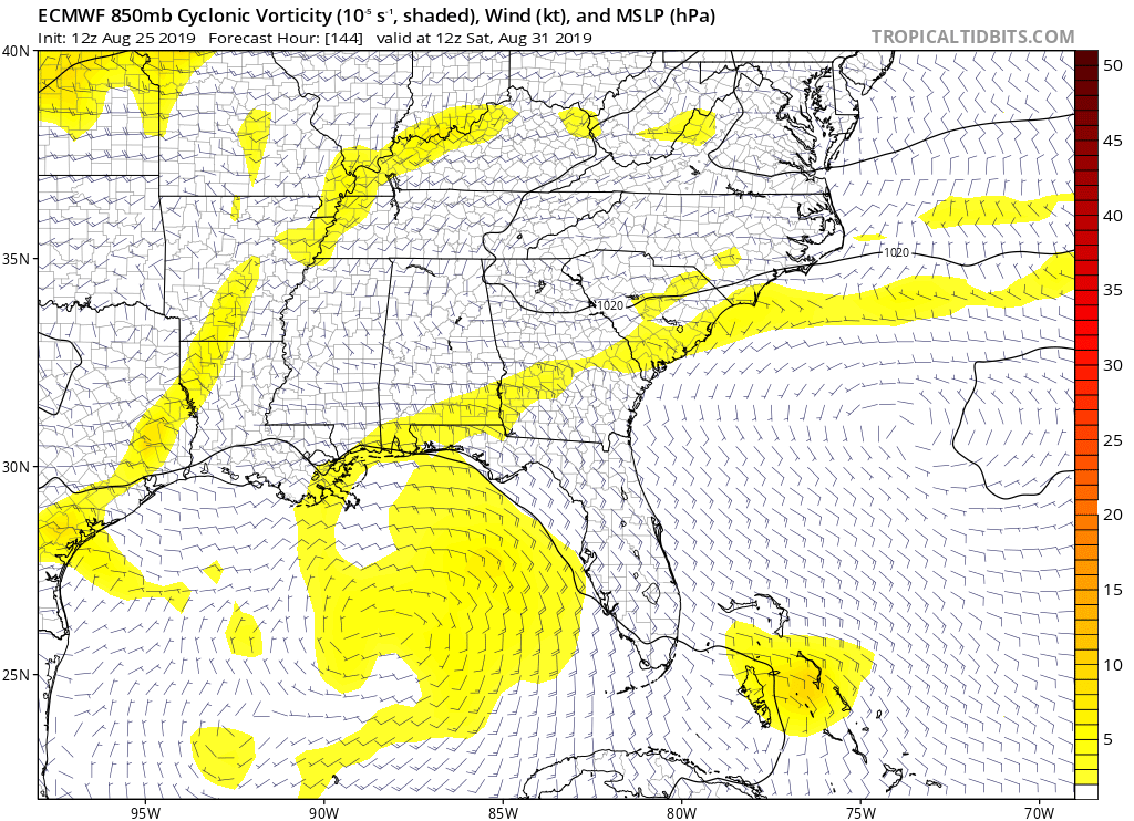
12Z Euro is a bit more organized and as a result shifted slightly more to the right. The remnant vorticity ends up in the Bahamas and then Southern Florida. What if Dorian ends up stronger and misses Hispaniola to the right?
Last edited by gatorcane on Sun Aug 25, 2019 2:20 pm, edited 1 time in total.
0 likes
-
Blown Away

- S2K Supporter
- Posts: 10253
- Joined: Wed May 26, 2004 6:17 am
Re: ATL: DORIAN - Models

18z
The 18z TVCN consensus is usually followed closely by NHC, clear northly jump, maybe no skimming the N coast of Hispaniola vs going through the spine. Interested to see if the NHC adjusts intensity forecast???

12z
0 likes
Hurricane Eye Experience: David 79, Irene 99, Frances 04, Jeanne 04, Wilma 05… Hurricane Brush Experience: Andrew 92, Erin 95, Floyd 99, Matthew 16, Irma 17, Ian 22, Nicole 22…

Re: ATL: DORIAN - Models
“12Z Euro is a bit more organized and as a result shifted slightly more to the right. The remnant vorticity ends up in the Bahamas and then Southern Florida. What if Dorian ends up stronger and misses Hispaniola to the right?”
Then at +168 hr:

Then at +168 hr:
0 likes

Re: ATL: DORIAN - Models
18z SHIPS:
* ATLANTIC 2019 SHIPS INTENSITY FORECAST *
* IR SAT DATA AVAILABLE, OHC AVAILABLE *
* DORIAN AL052019 08/25/19 18 UTC *
TIME (HR) 0 6 12 18 24 36 48 60 72 84 96 108 120
V (KT) NO LAND 40 43 46 50 54 60 65 68 72 73 74 75 78
V (KT) LAND 40 43 46 50 54 60 65 68 72 73 74 46 49
V (KT) LGEM 40 43 45 48 51 57 64 70 74 78 79 48 53
Storm Type TROP TROP TROP TROP TROP TROP TROP TROP TROP TROP TROP TROP TROP
SHEAR (KT) 5 3 1 3 4 6 7 12 8 15 10 5 2
SHEAR ADJ (KT) 2 4 3 0 0 -1 0 -7 -2 -3 -4 -3 -1
SHEAR DIR 142 189 273 5 14 298 299 261 258 250 270 224 56
SST (C) 28.3 28.4 28.5 28.8 29.0 28.9 29.2 29.0 29.0 29.1 29.1 29.2 29.3
POT. INT. (KT) 141 143 145 149 152 150 156 152 152 153 153 155 157
ADJ. POT. INT. 141 143 145 149 152 150 155 149 147 146 144 145 145
200 MB T (C) -54.0 -54.0 -54.3 -54.4 -54.2 -54.2 -54.1 -54.2 -54.3 -54.4 -54.3 -54.4 -54.5
200 MB VXT (C) -0.2 -0.2 -0.2 -0.2 -0.2 -0.2 -0.2 -0.3 0.0 0.0 0.0 0.0 0.0
TH_E DEV (C) 11 11 10 10 11 10 12 11 12 12 13 13 12
700-500 MB RH 38 41 42 43 45 49 48 48 49 48 51 55 57
MODEL VTX (KT) 10 10 10 10 10 9 8 5 LOST LOST LOST LOST LOST
850 MB ENV VOR 17 13 9 7 12 6 14 14 17 7 -2 -15 -36
200 MB DIV -17 -4 1 -15 -13 5 23 20 40 4 6 7 18
700-850 TADV -5 -5 -3 -1 1 2 1 0 5 7 4 4 4
LAND (KM) 636 620 558 464 362 270 378 355 204 129 15 -44 89
LAT (DEG N) 11.4 11.6 11.8 12.1 12.4 13.1 14.1 15.2 16.1 17.0 18.2 19.4 20.7
LONG(DEG W) 53.5 54.6 55.8 57.0 58.1 60.2 62.3 64.3 66.4 68.3 69.8 71.3 72.8
STM SPEED (KT) 11 11 12 12 11 11 12 11 11 10 9 10 10
HEAT CONTENT 17 24 33 49 54 37 47 42 67 82 85 53 47
FORECAST TRACK FROM OFCI INITIAL HEADING/SPEED (DEG/KT):280/ 12 CX,CY: -11/ 2
T-12 MAX WIND: 35 PRESSURE OF STEERING LEVEL (MB): 548 (MEAN=620)
GOES IR BRIGHTNESS TEMP. STD DEV. 50-200 KM RAD: 14.9 (MEAN=14.5)
% GOES IR PIXELS WITH T < -20 C 50-200 KM RAD: 70.0 (MEAN=65.0)
PRELIM RI PROB (DV .GE. 35 KT IN 36 HR): 19.6
INDIVIDUAL CONTRIBUTIONS TO INTENSITY CHANGE
6 12 18 24 36 48 60 72 84 96 108 120
----------------------------------------------------------
SAMPLE MEAN CHANGE 1. 2. 3. 4. 6. 8. 9. 10. 11. 11. 12. 12.
SST POTENTIAL 1. 1. 2. 2. 4. 8. 13. 18. 21. 23. 26. 27.
VERTICAL SHEAR MAG 1. 2. 3. 5. 7. 9. 10. 11. 11. 10. 11. 12.
VERTICAL SHEAR ADJ 0. 0. 0. 0. 0. 0. 2. 3. 3. 3. 3. 2.
VERTICAL SHEAR DIR 0. 0. 0. 0. 0. -1. -2. -3. -5. -5. -6. -6.
PERSISTENCE 1. 1. 1. 1. 1. 0. 0. 0. 0. 0. 0. 0.
200/250 MB TEMP. 0. 0. -1. -1. 0. 0. 0. 0. 0. 1. 1. 2.
THETA_E EXCESS 0. 0. 1. 1. 1. 1. 1. 1. 1. 1. 1. 1.
700-500 MB RH 0. 0. 1. 1. 1. 2. 2. 2. 2. 2. 2. 1.
MODEL VTX TENDENCY 0. 0. -1. -1. -2. -5. -9. -10. -11. -12. -13. -14.
850 MB ENV VORTICITY 0. 0. 0. 0. 0. -1. -1. -1. -1. -1. -1. -2.
200 MB DIVERGENCE 0. 0. -1. -1. -1. -1. -1. -1. -1. 0. 0. 1.
850-700 T ADVEC 0. 0. 0. 0. 0. 0. -1. 0. 0. 0. 0. 0.
ZONAL STORM MOTION 0. 0. 0. 0. 0. 1. 1. 1. 1. 2. 2. 2.
STEERING LEVEL PRES 0. 0. 0. 0. 1. 1. 0. 1. 1. 1. 1. 1.
DAYS FROM CLIM. PEAK 0. 0. 0. 0. 0. 0. 0. 0. 0. 0. 0. 0.
GOES PREDICTORS 0. 0. 1. 1. 0. 0. 0. -1. -1. -1. -1. -1.
OCEAN HEAT CONTENT 0. 0. 0. 0. 0. 0. 0. 0. 0. 0. 0. 0.
RI POTENTIAL 0. 1. 2. 3. 4. 3. 2. 1. 0. -1. -1. -2.
----------------------------------------------------------
TOTAL CHANGE 3. 6. 10. 14. 20. 25. 28. 32. 33. 34. 35. 38.
CURRENT MAX WIND (KT): 40. LAT, LON: 11.4 53.5
** 2019 ATLANTIC RI INDEX AL052019 DORIAN 08/25/19 18 UTC **
(SHIPS-RII PREDICTOR TABLE for 30 KT OR MORE MAXIMUM WIND INCREASE IN NEXT 24-h)
Predictor Value RI Predictor Range Scaled Value(0-1) % Contribution
12 HR PERSISTENCE (KT) : 5.0 -49.5 to 33.0 0.66 8.4
850-200 MB SHEAR (KT) : 3.4 30.1 to 2.3 0.96 4.6
HEAT CONTENT (KJ/CM2) : 35.4 0.0 to 151.8 0.23 1.0
STD DEV OF IR BR TEMP : 14.9 36.6 to 2.8 0.64 3.3
MAXIMUM WIND (KT) : 40.0 22.5 to 137.5 0.47 1.3
2nd PC OF IR BR TEMP : -0.1 2.9 to -2.9 0.52 1.8
POT = MPI-VMAX (KT) : 106.1 27.5 to 139.6 0.70 2.3
D200 (10**7s-1) : -9.6 -29.7 to 185.9 0.09 0.1
%area of TPW <45 mm upshear : 31.8 100.0 to 0.0 0.68 0.0
BL DRY-AIR FLUX (W/M2) : 356.2 895.4 to -55.0 0.57 0.0
SHIPS Prob RI for 20kt/ 12hr RI threshold= 8% is 1.5 times climatological mean ( 5.2%)
SHIPS Prob RI for 25kt/ 24hr RI threshold= 34% is 3.1 times climatological mean (10.9%)
SHIPS Prob RI for 30kt/ 24hr RI threshold= 23% is 3.3 times climatological mean ( 6.9%)
SHIPS Prob RI for 35kt/ 24hr RI threshold= 13% is 3.2 times climatological mean ( 3.8%)
SHIPS Prob RI for 40kt/ 24hr RI threshold= 12% is 5.4 times climatological mean ( 2.4%)
SHIPS Prob RI for 45kt/ 36hr RI threshold= 23% is 5.2 times climatological mean ( 4.5%)
SHIPS Prob RI for 55kt/ 48hr RI threshold= 33% is 7.2 times climatological mean ( 4.6%)
SHIPS Prob RI for 65kt/ 72hr RI threshold= 44% is 8.2 times climatological mean ( 5.4%)
0 likes
Very useful information on the Dvorak Technique --
https://severe.worldweather.wmo.int/TCF ... kBeven.pdf
https://severe.worldweather.wmo.int/TCF ... kBeven.pdf
-
Blown Away
- S2K Supporter
- Posts: 10253
- Joined: Wed May 26, 2004 6:17 am
Re: ATL: DORIAN - Models

12z Euro, Dorian energy tracks into SFL then into SE CONUS.
0 likes
Hurricane Eye Experience: David 79, Irene 99, Frances 04, Jeanne 04, Wilma 05… Hurricane Brush Experience: Andrew 92, Erin 95, Floyd 99, Matthew 16, Irma 17, Ian 22, Nicole 22…

Re: ATL: DORIAN - Models
Compared to its run last night more members jump on board of a more track north of Hispaniola.

1 likes
-
Blown Away
- S2K Supporter
- Posts: 10253
- Joined: Wed May 26, 2004 6:17 am
Re: ATL: DORIAN - Models

18z
Compared to 12z, clearly see an uptick 18z intensity guidance likely due to less interaction with Hispaniola... Trend to watch IMO..

12z
0 likes
Hurricane Eye Experience: David 79, Irene 99, Frances 04, Jeanne 04, Wilma 05… Hurricane Brush Experience: Andrew 92, Erin 95, Floyd 99, Matthew 16, Irma 17, Ian 22, Nicole 22…
Re: ATL: DORIAN - Models
Looking more organized earlier but less now: http://tropic.ssec.wisc.edu/real-time/s ... 000&loop=0
0 likes
Re: ATL: DORIAN - Models
NDG wrote:Compared to its run last night more members jump on board of a more track north of Hispaniola.
https://i.imgur.com/D9dZvCT.png
Note to the readers that there are ~51 Euro ens members. So, only ~8 of the 51 or ~16% actually hit the CONUS with a TD+, ~8% with a TS+, and ~6% with a H. The key is what is going to survive once it comes out of the Caribbean. IF it survives, it will probably have a path to or at least near to the CONUS. But, if so, hopefully it would be weak and not regenerate too much.
2 likes
Personal Forecast Disclaimer:
The posts in this forum are NOT official forecasts and should not be used as such. They are just the opinion of the poster and may or may not be backed by sound meteorological data. They are NOT endorsed by any professional institution or storm2k.org. For official information, please refer to the NHC and NWS products.
The posts in this forum are NOT official forecasts and should not be used as such. They are just the opinion of the poster and may or may not be backed by sound meteorological data. They are NOT endorsed by any professional institution or storm2k.org. For official information, please refer to the NHC and NWS products.
-
Blown Away
- S2K Supporter
- Posts: 10253
- Joined: Wed May 26, 2004 6:17 am
Re: ATL: DORIAN - Models
GFS/Euro basically do nothing with Dorian, hard to go against those models...
0 likes
Hurricane Eye Experience: David 79, Irene 99, Frances 04, Jeanne 04, Wilma 05… Hurricane Brush Experience: Andrew 92, Erin 95, Floyd 99, Matthew 16, Irma 17, Ian 22, Nicole 22…
-
Hurricaneman

- Category 5

- Posts: 7404
- Age: 45
- Joined: Tue Aug 31, 2004 3:24 pm
- Location: central florida
Re: ATL: DORIAN - Models
Blown Away wrote:GFS/Euro basically do nothing with Dorian, hard to go against those models...
We’ll know more after the recon data is put in the models
2 likes
-
gatorcane
- S2K Supporter
- Posts: 23703
- Age: 47
- Joined: Sun Mar 13, 2005 3:54 pm
- Location: Boca Raton, FL
Re: ATL: DORIAN - Models
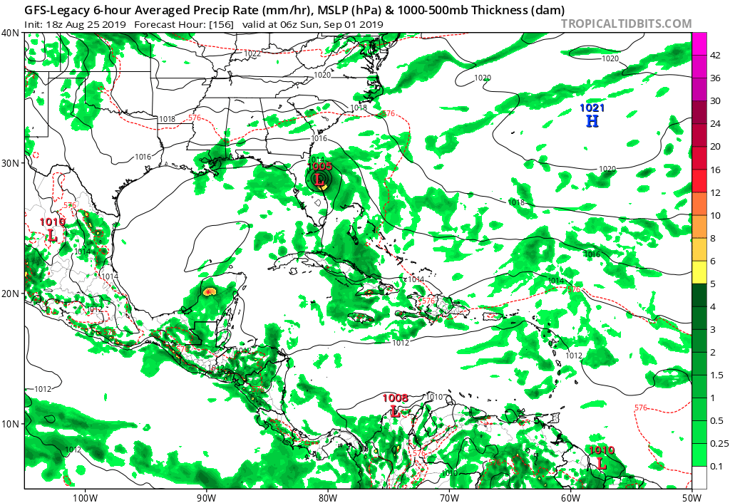
The GFS legacy moves this north of Hispaniola with a TS into Florida. The new GFS brings the vorticity just north of Hispaniola too but without development. Looks close though like it almost tries to respin up the vort:
0 likes
-
SouthFLTropics

- Category 5
- Posts: 4258
- Age: 50
- Joined: Thu Aug 14, 2003 8:04 am
- Location: Port St. Lucie, Florida
Re: ATL: DORIAN - Models
12Z NAVGEM has a treat for South Florida
3 likes
Fourth Generation Florida Native
Personal Storm History: David 79, Andrew 92, Erin 95, Floyd 99, Irene 99, Frances 04, Jeanne 04, Wilma 05, Matthew 16, Irma 17, Ian 22, Nicole 22, Milton 24
Personal Storm History: David 79, Andrew 92, Erin 95, Floyd 99, Irene 99, Frances 04, Jeanne 04, Wilma 05, Matthew 16, Irma 17, Ian 22, Nicole 22, Milton 24
-
Blown Away
- S2K Supporter
- Posts: 10253
- Joined: Wed May 26, 2004 6:17 am
Re: ATL: DORIAN - Models
SouthFLTropics wrote:[url]https://www.minpic.de/t/8hmc/vq322 [/url]
12Z NAVGEM has a treat for South Florida

2 likes
Hurricane Eye Experience: David 79, Irene 99, Frances 04, Jeanne 04, Wilma 05… Hurricane Brush Experience: Andrew 92, Erin 95, Floyd 99, Matthew 16, Irma 17, Ian 22, Nicole 22…
-
Blown Away
- S2K Supporter
- Posts: 10253
- Joined: Wed May 26, 2004 6:17 am
Re: ATL: DORIAN - Models

18z GFS Legacy.
0 likes
Hurricane Eye Experience: David 79, Irene 99, Frances 04, Jeanne 04, Wilma 05… Hurricane Brush Experience: Andrew 92, Erin 95, Floyd 99, Matthew 16, Irma 17, Ian 22, Nicole 22…
-
Blown Away
- S2K Supporter
- Posts: 10253
- Joined: Wed May 26, 2004 6:17 am
Re: ATL: DORIAN - Models

12z CMC/GEM/Canadian
1 likes
Hurricane Eye Experience: David 79, Irene 99, Frances 04, Jeanne 04, Wilma 05… Hurricane Brush Experience: Andrew 92, Erin 95, Floyd 99, Matthew 16, Irma 17, Ian 22, Nicole 22…
Who is online
Users browsing this forum: No registered users and 17 guests