ATL: DORIAN - Models
Moderator: S2k Moderators
-
TheStormExpert
Re: ATL: DORIAN - Models
I do wonder if the GFS is too struggling now with the size of Dorian. If conditions are favorable until the islands then why doesn’t it strengthen it much?
0 likes


-
eastcoastFL

- Category 5

- Posts: 3996
- Age: 44
- Joined: Thu Apr 12, 2007 12:29 pm
- Location: Palm City, FL
Re: ATL: DORIAN - Models
Taffy wrote:I am the bear that is watching from SW Florida.
I’m bear watching in SE Florida ....
0 likes
Personal Forecast Disclaimer:
The posts in this forum are NOT official forecast and should not be used as such. They are just the opinion of the poster and may or may not be backed by sound meteorological data. They are NOT endorsed by any professional institution or storm2k.org. For official information, please refer to the NHC and NWS products.
The posts in this forum are NOT official forecast and should not be used as such. They are just the opinion of the poster and may or may not be backed by sound meteorological data. They are NOT endorsed by any professional institution or storm2k.org. For official information, please refer to the NHC and NWS products.
-
plasticup
Re: ATL: DORIAN - Models
Cpv17 wrote:mpic wrote:It's been upgraded to Tropical Storm Dorian.
Yeah I’m not sure why the title hasn’t been changed yet.
It is done manually and therefore sometimes has a short delay.
2 likes
Re: ATL: DORIAN - Models
i'm going with the NHC on this one, the models in general aren't handling the setup in the Atlantic well at all this year. (Just go back several days and compare to what's out there now to see how bad it is)
0 likes

Re: ATL: DORIAN - Models
18Z HWRF has a hurricane that appears headed for Puerto Rico(or maybe the strait) after passing over Dominica.
0 likes
-
AtlanticWind

- S2K Supporter

- Posts: 1898
- Age: 67
- Joined: Sun Aug 08, 2004 9:57 pm
- Location: Plantation,Fla
-
gatorcane

- S2K Supporter
- Posts: 23708
- Age: 48
- Joined: Sun Mar 13, 2005 3:54 pm
- Location: Boca Raton, FL
Re: ATL: DORIAN - Models
18Z HWRF stronger than 12Z run and heading toward Puerto Rico (958 MB):
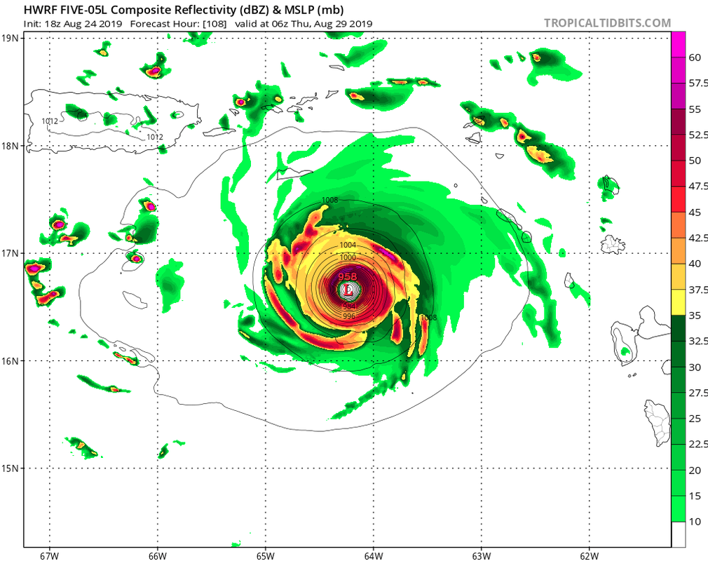
Last edited by gatorcane on Sat Aug 24, 2019 7:01 pm, edited 1 time in total.
0 likes
-
AtlanticWind
- S2K Supporter
- Posts: 1898
- Age: 67
- Joined: Sun Aug 08, 2004 9:57 pm
- Location: Plantation,Fla
-
gatorcane
- S2K Supporter
- Posts: 23708
- Age: 48
- Joined: Sun Mar 13, 2005 3:54 pm
- Location: Boca Raton, FL
Re: ATL: DORIAN - Models
18Z HWRF simulated IR. Headed toward Puerto Rico double:
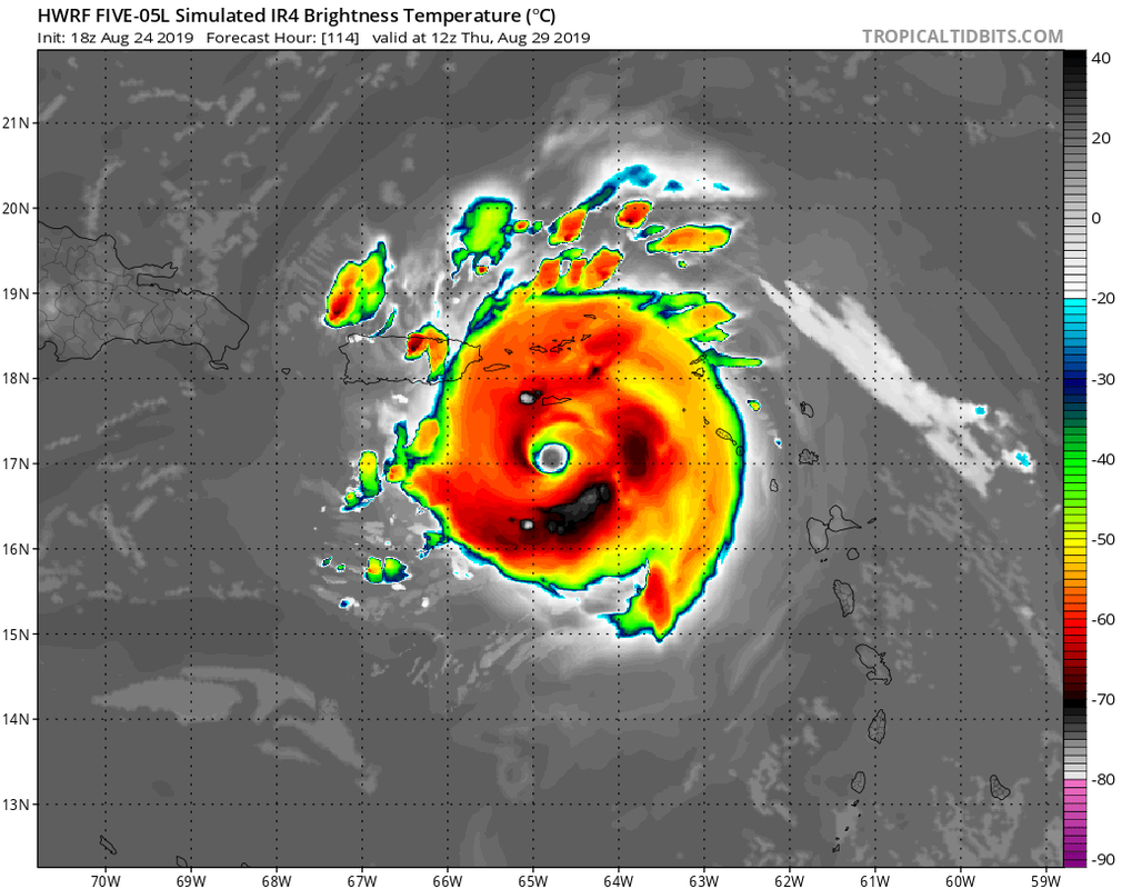
Last edited by gatorcane on Sat Aug 24, 2019 7:05 pm, edited 1 time in total.
3 likes

Re: ATL: DORIAN - Models

It's like a flashback to Maria.
0 likes
Igor 2010, Sandy 2012, Fay 2014, Gonzalo 2014, Joaquin 2015, Nicole 2016, Humberto 2019, Imelda 2025
I am only a tropical weather enthusiast. My predictions are not official and may or may not be backed by sound meteorological data. For official information, please refer to the NHC and NWS products.
I am only a tropical weather enthusiast. My predictions are not official and may or may not be backed by sound meteorological data. For official information, please refer to the NHC and NWS products.
Re: ATL: DORIAN - Models
strongest quadrant of the eyewall would travel over San Juan for this 18Z HWRF run with about 970 MB pressures which probably means cat 1.
3 likes
-
Kingarabian

- S2K Supporter
- Posts: 16384
- Joined: Sat Aug 08, 2009 3:06 am
- Location: Honolulu, Hawaii
Re: ATL: DORIAN - Models
Nimbus wrote:strongest quadrant of the eyewall would travel over San Juan for this 18Z HWRF run with about 970 MB pressures which probably means cat 1.
970mb is most likely Cat.2.
2 likes
RIP Kobe Bryant
-
gatorcane
- S2K Supporter
- Posts: 23708
- Age: 48
- Joined: Sun Mar 13, 2005 3:54 pm
- Location: Boca Raton, FL
Re: ATL: DORIAN - Models
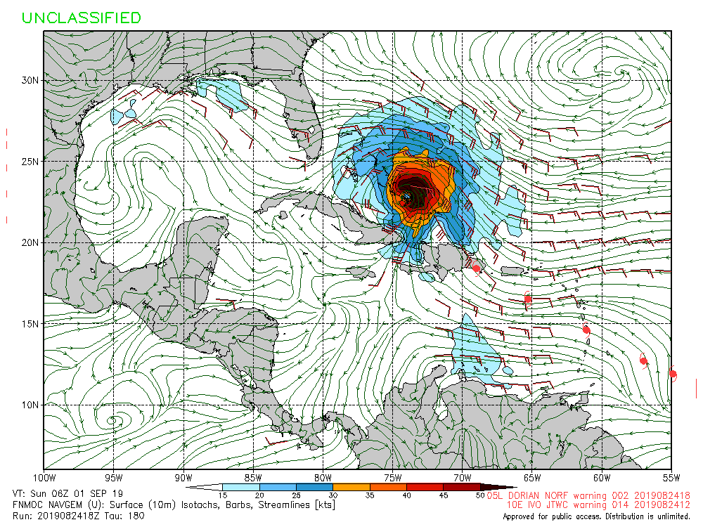
The 18Z NAVGEM jumps on board for the first time sending this through Puerto Rico and into the Bahamas with the system growing in size. Thankfully it is a poor performing global model but hmmm:
1 likes
-
northjaxpro

- S2K Supporter
- Posts: 8900
- Joined: Mon Sep 27, 2010 11:21 am
- Location: Jacksonville, FL
Re: ATL: DORIAN - Models
Interesting next week ahead with Dorian. So much to watch. Hope all in the Caribbean are preparing down there with this storm . It could be become a big one.
A lot as always looking down the road will be the HUGE ? if Dorian can avoiid the shredder aka as Hispaniola. This will carry HUGE potential implications with regards to the prospects concerning the CONUS.
A lot as always looking down the road will be the HUGE ? if Dorian can avoiid the shredder aka as Hispaniola. This will carry HUGE potential implications with regards to the prospects concerning the CONUS.
Last edited by northjaxpro on Sat Aug 24, 2019 10:10 pm, edited 1 time in total.
0 likes
NEVER, EVER SAY NEVER in the tropics and weather in general, and most importantly, with life itself!!
________________________________________________________________________________________
Fay 2008 Beryl 2012 Debby 2012 Colin 2016 Hermine 2016 Julia 2016 Matthew 2016 Irma 2017 Dorian 2019
________________________________________________________________________________________
Fay 2008 Beryl 2012 Debby 2012 Colin 2016 Hermine 2016 Julia 2016 Matthew 2016 Irma 2017 Dorian 2019
-
Chris_in_Tampa
- Category 5
- Posts: 5101
- Age: 42
- Joined: Thu Jun 21, 2007 11:06 pm
- Location: Tampa, Florida, USA
- Contact:
Re: ATL: DORIAN - Models
8pm EDT Saturday SHIPS intensity output:
From bottom of this folder: https://ftp.nhc.noaa.gov/atcf/stext/
The current intensity is 35 knots. (40mph) As of the 8pm EDT SHIPS intensity output, there remains a 33% chance of a 65 knot (75mph) increase over 72 hours (3 days). That would be 100 knots. (about 115mph)
Code: Select all
                    * ATLANTIC     2019 SHIPS INTENSITY FORECAST     *
                    * IR SAT DATA AVAILABLE,       OHC AVAILABLE     *
                    *  DORIAN      AL052019  08/25/19  00 UTC        *

TIME (HR)          0     6    12    18    24    36    48    60    72    84    96   108   120
V (KT) NO LAND    35    37    40    43    46    52    59    67    69    72    72    71    71
V (KT) LAND       35    37    40    43    46    52    59    67    69    72    72    71    53
V (KT) LGEM       35    37    39    42    44    51    58    65    70    71    70    68    51
Storm Type      TROP  TROP  TROP  TROP  TROP  TROP  TROP  TROP  TROP  TROP  TROP  TROP  TROP

SHEAR (KT)         8     5     4     5     3    10     4    11    17    12    14    18     8
SHEAR ADJ (KT)     2     3     2     2     4     0    -2     0    -8    -4     0    -6     0
SHEAR DIR        138   120    62    43    14   352   313   291   247   252   214   245   208
SST (C)         28.0  28.0  28.0  28.2  28.3  28.6  29.0  29.1  29.3  29.2  29.2  29.1  29.2
POT. INT. (KT)   137   137   137   140   141   146   152   154   157   155   155   153   155
ADJ. POT. INT.   137   136   135   139   141   145   151   153   155   150   149   146   147
200 MB T (C)   -53.8 -54.0 -54.2 -54.1 -54.1 -54.4 -54.0 -54.1 -53.8 -54.3 -54.2 -54.4 -54.2
200 MB VXT (C)  -0.2  -0.2  -0.2  -0.2  -0.2  -0.2  -0.3  -0.2  -0.2  -0.2  -0.1  -0.2  -0.2
TH_E DEV (C)       9     9    10    10    10    10    10    10    11    11    12    11    12
700-500 MB RH     42    39    38    39    41    43    45    49    47    49    50    53    55
MODEL VTX (KT)    13    12    12    11    11    10    10    11     8     8     7     6     4
850 MB ENV VOR    39    28    17    18    16     9    12    11     8    19    18     6     1
200 MB DIV        -5   -14   -26   -23    -8   -10   -10    27    10    27    43    -3     9
700-850 TADV      -7    -7    -7    -6    -5    -3     0     1    -2     0     0     2    -5
LAND (KM)        714   690   668   651   653   569   413   369   487   256   121    61   -25
LAT (DEG N)     10.8  11.1  11.3  11.5  11.6  12.3  13.2  14.0  15.3  16.2  16.9  17.8  19.1
LONG(DEG W)     49.7  50.8  51.8  52.8  53.9  56.0  58.1  60.1  62.3  64.4  66.3  68.2  69.9
STM SPEED (KT)    11    11    10    10    11    11    11    12    12    10    10    10    10
HEAT CONTENT      12    11    12    14    19    36    42    38    54    49    69    83    68

  FORECAST TRACK FROM OFCI      INITIAL HEADING/SPEED (DEG/KT):280/ 11      CX,CY: -10/  2
  T-12 MAX WIND:  30            PRESSURE OF STEERING LEVEL (MB):  538  (MEAN=620)
  GOES IR BRIGHTNESS TEMP. STD DEV.  50-200 KM RAD:  16.9 (MEAN=14.5)
  % GOES IR PIXELS WITH T < -20 C    50-200 KM RAD:  52.0 (MEAN=65.0)
  PRELIM RI PROB (DV .GE. 35 KT IN 36 HR):           12.0

                        INDIVIDUAL CONTRIBUTIONS TO INTENSITY CHANGE
                         6   12   18   24   36   48   60   72   84   96  108  120
                        ----------------------------------------------------------
  SAMPLE MEAN CHANGE     1.   2.   3.   4.   6.   8.   9.  10.  11.  11.  12.  12.
  SST POTENTIAL          1.   1.   1.   2.   4.   8.  14.  19.  23.  26.  28.  31.
  VERTICAL SHEAR MAG     1.   2.   3.   4.   6.   8.   9.   9.   8.   8.   7.   7.
  VERTICAL SHEAR ADJ     0.   0.   0.  -1.  -1.   0.   0.   2.   3.   2.   2.   2.
  VERTICAL SHEAR DIR     0.   0.   1.   2.   3.   3.   3.   2.   0.  -1.  -2.  -3.
  PERSISTENCE            1.   1.   1.   1.   1.   0.   0.   0.   0.   0.   0.   0.
  200/250 MB TEMP.       0.   0.  -1.  -1.   0.   0.   0.   0.   0.   1.   1.   2.
  THETA_E EXCESS         0.   0.   0.   0.   1.   1.   1.   1.   1.   1.   1.   1.
  700-500 MB RH          0.   0.   1.   1.   1.   2.   3.   3.   3.   3.   2.   2.
  MODEL VTX TENDENCY     0.  -1.  -1.  -2.  -3.  -4.  -5.  -9. -10. -13. -15. -17.
  850 MB ENV VORTICITY   0.   0.   0.   0.   0.   0.   0.  -1.  -1.  -1.  -1.  -1.
  200 MB DIVERGENCE      0.  -1.  -1.  -1.  -2.  -1.  -1.  -1.  -1.   0.   0.   1.
  850-700 T ADVEC        0.   0.   0.   0.  -1.  -1.  -1.  -1.  -1.   0.   0.   0.
  ZONAL STORM MOTION     0.   0.   0.   0.   0.   1.   1.   1.   1.   2.   2.   2.
  STEERING LEVEL PRES    0.   0.   0.   0.   1.   1.   0.   1.   1.   1.   1.   1.
  DAYS FROM CLIM. PEAK   0.   0.   0.   0.   0.   0.   0.   0.   0.   0.   0.   0.
  GOES PREDICTORS        0.   0.   0.   0.   0.  -1.  -2.  -2.  -2.  -2.  -2.  -2.
  OCEAN HEAT CONTENT     0.   0.   0.   0.   0.   0.   0.   0.   0.   0.   0.   0.
  RI POTENTIAL           0.   0.   0.   1.   1.   1.   0.   0.   0.   0.   0.   0.
                        ----------------------------------------------------------
  TOTAL CHANGE           2.   5.   8.  11.  17.  24.  32.  34.  37.  37.  36.  36.

                CURRENT MAX WIND (KT):   35. LAT, LON:   10.8    49.7

      ** 2019 ATLANTIC RI INDEX AL052019 DORIAN     08/25/19  00 UTC **
 (SHIPS-RII PREDICTOR TABLE for 30 KT OR MORE MAXIMUM WIND INCREASE IN NEXT 24-h)

     Predictor                  Value   RI Predictor Range  Scaled Value(0-1) % Contribution
 12 HR PERSISTENCE (KT)      :    5.0    -49.5  to   33.0        0.66           6.1
 850-200 MB SHEAR (KT)       :    5.1     30.1  to    2.3        0.90           3.2
 HEAT CONTENT (KJ/CM2)       :   13.6      0.0  to  151.8        0.09           0.3
 STD DEV OF IR BR TEMP       :   16.9     36.6  to    2.8        0.58           2.2
 MAXIMUM WIND (KT)           :   35.0     22.5  to  137.5        0.33           0.7
 2nd PC OF IR BR TEMP        :   -0.6      2.9  to   -2.9        0.60           1.5
 POT = MPI-VMAX (KT)         :  102.9     27.5  to  139.6        0.67           1.7
 D200 (10**7s-1)             :  -15.2    -29.7  to  185.9        0.07           0.1
 %area of TPW <45 mm upshear :   40.8    100.0  to    0.0        0.59           0.0
 BL DRY-AIR FLUX (W/M2)      :  313.4    895.4  to  -55.0        0.61           0.0

 SHIPS Prob RI for 20kt/ 12hr RI threshold=   7% is   1.3 times climatological mean ( 5.2%)
 SHIPS Prob RI for 25kt/ 24hr RI threshold=  23% is   2.1 times climatological mean (10.9%)
 SHIPS Prob RI for 30kt/ 24hr RI threshold=  16% is   2.3 times climatological mean ( 6.9%)
 SHIPS Prob RI for 35kt/ 24hr RI threshold=  12% is   2.7 times climatological mean ( 3.8%)
 SHIPS Prob RI for 40kt/ 24hr RI threshold=  10% is   4.6 times climatological mean ( 2.4%)
 SHIPS Prob RI for 45kt/ 36hr RI threshold=  13% is   2.8 times climatological mean ( 4.5%)
 SHIPS Prob RI for 55kt/ 48hr RI threshold=  21% is   4.5 times climatological mean ( 4.6%)
 SHIPS Prob RI for 65kt/ 72hr RI threshold=  33% is   6.2 times climatological mean ( 5.4%)

Matrix of RI probabilities
------------------------------------------------------------------------------
  RI (kt / h)  | 20/12 | 25/24 | 30/24 | 35/24 | 40/24 | 45/36 | 55/48  |65/72
------------------------------------------------------------------------------
   SHIPS-RII:     6.7%   22.5%   15.7%   11.8%    9.5%   12.6%   20.8%   33.3%
    Logistic:     6.1%   26.3%   21.1%    9.9%    4.9%   14.7%   18.6%   21.2%
    Bayesian:     0.5%   11.8%    2.6%    0.0%    0.0%    0.9%    2.0%    0.6%
   Consensus:     4.4%   20.2%   13.1%    7.3%    4.8%    9.4%   13.8%   18.4%
       DTOPS:     1.0%    2.0%    1.0%    0.0%    0.0%    0.0%    3.0%    5.0%

   ##         ANNULAR HURRICANE INDEX (AHI) AL052019 DORIAN     08/25/19  00 UTC         ##
   ## STORM NOT ANNULAR, SCREENING STEP FAILED, NPASS=4 NFAIL=3                          ##
   ## AHI=  0   (AHI OF 100 IS BEST FIT TO ANN. STRUC., 1 IS MARGINAL, 0 IS NOT ANNULAR) ##

** PROBLTY OF AT LEAST 1 SCNDRY EYEWL FORMTN EVENT AL052019 DORIAN     08/25/2019  00 UTC **
TIME(HR)   0-12  12-24(0-24)  24-36(0-36)  36-48(0-48)
CLIMO(%)     0      0(  0)       0(  0)       0(  0)     <-- PROB BASED ON INTENSITY ONLY
PROB(%)      0      0(  0)       0(  0)       0(  0)     <-- FULL MODEL PROB (RAN NORMALLY)

** DSHIPS INTENSITY FORECAST ADJUSTED RELATIVE TO ONSET OF ERC WEAKENING PHASE **
      TIME (HR)      0     6    12    18    24    36    48    60    72    84    96   108   120
>24HR AGO (DSHIPS)  35    37    40    43    46    52    59    67    69    72    72    71    53
 18HR AGO           35    34    37    40    43    49    56    64    66    69    69    68    50
 12HR AGO           35    32    31    34    37    43    50    58    60    63    63    62    44
  6HR AGO           35    29    26    25    28    34    41    49    51    54    54    53    35
      NOW                              CURRENT INTENSITY < 83 KT
  IN  6HR                              INTENSITY IN  6HR < 83 KT
  IN 12HR                              INTENSITY IN 12HR < 83 KT
From bottom of this folder: https://ftp.nhc.noaa.gov/atcf/stext/
The current intensity is 35 knots. (40mph) As of the 8pm EDT SHIPS intensity output, there remains a 33% chance of a 65 knot (75mph) increase over 72 hours (3 days). That would be 100 knots. (about 115mph)
1 likes
-
AxaltaRacing24
- Category 5
- Posts: 1774
- Age: 25
- Joined: Wed Jul 27, 2016 11:14 am
- Location: Jupiter, FL
Re: ATL: DORIAN - Models
sma10 wrote:gatorcane wrote:The 18Z NAVGEM jumps on board for the first time sending this through Puerto Rico and into the Bahamas with the system growing in size. Thankfully it is a poor performing global model but hmmm:
https://i.postimg.cc/tgZ28hVm/nvg10-sfc10m-180-go-mex.gif
Obviously attention needs to be paid by the SE US coast ... but historically speaking I would find it difficult to believe that a storm positioned as far south as Dorian currently is would traverse the eastern caribbean and pop out on the other side unscathed.
it will come down to whether if it misses hispaniola or not.
0 likes
Re: ATL: DORIAN - Models
AxaltaRacing24 wrote:sma10 wrote:gatorcane wrote:The 18Z NAVGEM jumps on board for the first time sending this through Puerto Rico and into the Bahamas with the system growing in size. Thankfully it is a poor performing global model but hmmm:
https://i.postimg.cc/tgZ28hVm/nvg10-sfc10m-180-go-mex.gif
Obviously attention needs to be paid by the SE US coast ... but historically speaking I would find it difficult to believe that a storm positioned as far south as Dorian currently is would traverse the eastern caribbean and pop out on the other side unscathed.
it will come down to whether if it misses hispaniola or not.
True, slamming directly into it will likely destroy Dorian. But even getting CLOSE to Hispaniola tends to unravel systems. Seen it happen so many times.
2 likes

Who is online
Users browsing this forum: No registered users and 52 guests