2019 Indicators: SST'S / Sal / MSLP / Steering / Shear / Instability (See updated graphics at first post)

This is the general tropical discussion area. Anyone can take their shot at predicting a storms path.

Moderator: S2k Moderators

Forum rules

The posts in this forum are NOT official forecasts and should not be used as such. They are just the opinion of the poster and may or may not be backed by sound meteorological data. They are NOT endorsed by any professional institution or STORM2K. For official information, please refer to products from the National Hurricane Center and National Weather Service.

Help Support Storm2K
Message
Author
User avatar
toad strangler
S2K Supporter
S2K Supporter
Posts: 4543
Joined: Sun Jul 28, 2013 3:09 pm
Location: Earth
Contact:

Re: 2019 Indicators: SST'S / Sal / MSLP / Steering / Shear / Instability (See updated graphics at first post)

#961 Postby toad strangler » Sat Aug 17, 2019 1:14 pm

gatorcane wrote:The trough has been a persistent feature this summer unlike the summers from 2015-2017 (and to some extent 2018) where we had deep east flow. Might be an indicator any storms that do form this year that try to approach from the east of Florida would recurve away.

NWS Miami even mentions how persistent the trough has been in last night’s discussion and you can see the impact to the sensible forecast:

REST OF NEXT WEEK: An upper level low digging towards the Great
Lakes midweek will reinforce the persistent eastern US trough
that has been around for a good bit of the summer. While not as
strong as we`ve seen it earlier this summer, the result will be an
eroding of the western edge of the ridge, with mid-upper level
flow veering out of the south southeast.

https://forecast.weather.gov/product.ph ... glossary=0


This is generally a climo setup for FL and the SE coast should it persist.
2 likes   

User avatar
Hammy
Category 5
Category 5
Posts: 5849
Age: 41
Joined: Fri May 25, 2012 5:25 pm
Contact:

Re: 2019 Indicators: SST'S / Sal / MSLP / Steering / Shear / Instability (See updated graphics at first post)

#962 Postby Hammy » Sat Aug 17, 2019 1:16 pm

CFS has been backing off now the past three runs, seems like new data has come out at some point in the last week or so that isn't so keen on as much of a season as earlier shown (and the GFS appears to have ceased it's forecasts of the monsoon trough over Africa moving south any), and it also seems odd that the atmospheric wave propagation just completely stops entirely.
Image


Long run of the model appears to show 3-4 storms, two hurricanes, with one major for September (with one storm being in the Gulf) and 3-4 storms with 1-2 hurricanes in October (no majors) with again one tropical storm in the Gulf (and one of the Atlantic ones being questionable if tropical) and nothing at all in November. Not backing off my forecast quite yet but there's been a decided trend and not flipping back and fourth every few runs so worth asking what some professional takes on this with the graph are.
Last edited by Hammy on Sat Aug 17, 2019 1:29 pm, edited 1 time in total.
2 likes   
The above post is not official and should not be used as such. It is the opinion of the poster and may or may not be backed by sound meteorological data. It is not endorsed by any professional institution or storm2k.org. For official information, please refer to the NHC and NWS products.

AutoPenalti
Category 5
Category 5
Posts: 4030
Age: 29
Joined: Mon Aug 17, 2015 4:16 pm
Location: Ft. Lauderdale, Florida

Re: 2019 Indicators: SST'S / Sal / MSLP / Steering / Shear / Instability (See updated graphics at first post)

#963 Postby AutoPenalti » Sat Aug 17, 2019 1:25 pm

If no TC’s form from here on to November would that mean this year would be the most inactive season on record?
0 likes   
The posts in this forum are NOT official forecasts and should not be used as such. They are just the opinion of the poster and may or may not be backed by sound meteorological data. They are NOT endorsed by any professional institution or STORM2K. For official information, please refer to products from the NHC and NWS.


Model Runs Cheat Sheet:
GFS (5:30 AM/PM, 11:30 AM/PM)
HWRF, GFDL, UKMET, NAVGEM (6:30-8:00 AM/PM, 12:30-2:00 AM/PM)
ECMWF (1:45 AM/PM)

TCVN
is a weighted averaged

User avatar
Ubuntwo
Category 5
Category 5
Posts: 1406
Age: 31
Joined: Thu Oct 05, 2017 10:41 pm

Re: 2019 Indicators: SST'S / Sal / MSLP / Steering / Shear / Instability (See updated graphics at first post)

#964 Postby Ubuntwo » Sat Aug 17, 2019 1:32 pm

AutoPenalti wrote:If no TC’s form from here on to November would that mean this year would be the most inactive season on record?

No it would not, but that won’t happen. The season may be below average but there will still be storms. And with this sort of steering pattern and SSTs near Florida it really only takes one.
1 likes   
Kendall -> SLO -> PBC

Memorable Storms: Katrina (for its Florida landfall...) Wilma Matthew Irma

AutoPenalti
Category 5
Category 5
Posts: 4030
Age: 29
Joined: Mon Aug 17, 2015 4:16 pm
Location: Ft. Lauderdale, Florida

Re: 2019 Indicators: SST'S / Sal / MSLP / Steering / Shear / Instability (See updated graphics at first post)

#965 Postby AutoPenalti » Sat Aug 17, 2019 1:34 pm

Ubuntwo wrote:
AutoPenalti wrote:If no TC’s form from here on to November would that mean this year would be the most inactive season on record?

No it would not, but that won’t happen. The season may be below average but there will still be storms. And with this sort of steering pattern and SSTs near Florida it really only takes one.

So what has been the most inactive season, historically?
0 likes   
The posts in this forum are NOT official forecasts and should not be used as such. They are just the opinion of the poster and may or may not be backed by sound meteorological data. They are NOT endorsed by any professional institution or STORM2K. For official information, please refer to products from the NHC and NWS.


Model Runs Cheat Sheet:
GFS (5:30 AM/PM, 11:30 AM/PM)
HWRF, GFDL, UKMET, NAVGEM (6:30-8:00 AM/PM, 12:30-2:00 AM/PM)
ECMWF (1:45 AM/PM)

TCVN
is a weighted averaged

User avatar
Ubuntwo
Category 5
Category 5
Posts: 1406
Age: 31
Joined: Thu Oct 05, 2017 10:41 pm

Re: 2019 Indicators: SST'S / Sal / MSLP / Steering / Shear / Instability (See updated graphics at first post)

#966 Postby Ubuntwo » Sat Aug 17, 2019 1:38 pm

AutoPenalti wrote:
Ubuntwo wrote:
AutoPenalti wrote:If no TC’s form from here on to November would that mean this year would be the most inactive season on record?

No it would not, but that won’t happen. The season may be below average but there will still be storms. And with this sort of steering pattern and SSTs near Florida it really only takes one.

So what has been the most inactive season, historically?

1914 with 1/0/0. There may have been a couple more storms but we’ll never know, no satellite.
2 likes   
Kendall -> SLO -> PBC

Memorable Storms: Katrina (for its Florida landfall...) Wilma Matthew Irma

User avatar
Hurricaneman
Category 5
Category 5
Posts: 7351
Age: 45
Joined: Tue Aug 31, 2004 3:24 pm
Location: central florida

Re: 2019 Indicators: SST'S / Sal / MSLP / Steering / Shear / Instability (See updated graphics at first post)

#967 Postby Hurricaneman » Sat Aug 17, 2019 1:54 pm

Looks like a model war between the Euro and JMA in which the lid comes off at the end of the month and the CFS which is the GFS in the super long range waiting until near mid September for the lid coming off, for those who like tracking more storms the Euro or JMA might be your models of choice, but if you want a quieter season the CFS would be the model to go with

But even if the quieter CFS happens doesn’t mean that one should shrug off this season as it only takes one to make it a bad season for someone
1 likes   

User avatar
Hammy
Category 5
Category 5
Posts: 5849
Age: 41
Joined: Fri May 25, 2012 5:25 pm
Contact:

Re: 2019 Indicators: SST'S / Sal / MSLP / Steering / Shear / Instability (See updated graphics at first post)

#968 Postby Hammy » Sat Aug 17, 2019 1:58 pm

Hurricaneman wrote:Looks like a model war between the Euro and JMA in which the lid comes off at the end of the month and the CFS which is the GFS in the super long range waiting until near mid September for the lid coming off, for those who like tracking more storms the Euro or JMA might be your models of choice, but if you want a quieter season the CFS would be the model to go with

But even if the quieter CFS happens doesn’t mean that one should shrug off this season as it only takes one to make it a bad season for someone


This does still seem like it'll be a west-based season (and much of the activity is centered near or just off the East Coast) but that unfavorable MDR is going to take a big chunk out of the numbers if it plays out.
2 likes   
The above post is not official and should not be used as such. It is the opinion of the poster and may or may not be backed by sound meteorological data. It is not endorsed by any professional institution or storm2k.org. For official information, please refer to the NHC and NWS products.

User avatar
CyclonicFury
Category 5
Category 5
Posts: 2025
Age: 26
Joined: Sun Jul 02, 2017 12:32 pm
Location: NC
Contact:

Re: 2019 Indicators: SST'S / Sal / MSLP / Steering / Shear / Instability (See updated graphics at first post)

#969 Postby CyclonicFury » Sat Aug 17, 2019 4:44 pm

What's even more surprising about this inactivity so far this month is there is not even a true El Niño present, and shear has actually been near normal.

I really thought we'd see a significant uptick with this CCKW considering climatology, but so far the models remain very bearish.
4 likes   
NCSU B.S. in Meteorology Class of 2021. Tropical weather blogger at http://www.cyclonicfury.com. My forecasts and thoughts are NOT official, for official forecasts please consult the National Hurricane Center.

User avatar
cycloneye
Admin
Admin
Posts: 145324
Age: 68
Joined: Thu Oct 10, 2002 10:54 am
Location: San Juan, Puerto Rico

Re: 2019 Indicators: SST'S / Sal / MSLP / Steering / Shear / Instability (See updated graphics at first post)

#970 Postby cycloneye » Sat Aug 17, 2019 4:49 pm

CyclonicFury wrote:What's even more surprising about this inactivity so far this month is there is not even a true El Niño present, and shear has actually been near normal.

I really thought we'd see a significant uptick with this CCKW considering climatology, but so far the models remain very bearish.


Dry air / Saharan air Layer a fairly big culprit.
4 likes   
Visit the Caribbean-Central America Weather Thread where you can find at first post web cams,radars
and observations from Caribbean basin members Click Here

User avatar
Kingarabian
S2K Supporter
S2K Supporter
Posts: 15981
Joined: Sat Aug 08, 2009 3:06 am
Location: Honolulu, Hawaii

Re: 2019 Indicators: SST'S / Sal / MSLP / Steering / Shear / Instability (See updated graphics at first post)

#971 Postby Kingarabian » Sat Aug 17, 2019 5:04 pm

In regards to sinking and rising motion: the EPS weeklies MEAN initialized on August 15 depict good potential for a back loaded Atlantic hurricane season. They show rising motion over the EPAC and Atlantic/MDR through August 21 before another round of sinking motion kicks in until the beginning of the 2nd week of September. After that, rising motion takes over through the end of September.

As for MSLP between 5N-25N, past September 5, (I haven't seen the MEAN yet), 90% of the EPS members including the CONTROL show low pressures compared to normal from the WGOM to just east of Africa. Some members show VERY low pressures compared to normal.
7 likes   
RIP Kobe Bryant

User avatar
Hurricaneman
Category 5
Category 5
Posts: 7351
Age: 45
Joined: Tue Aug 31, 2004 3:24 pm
Location: central florida

Re: 2019 Indicators: SST'S / Sal / MSLP / Steering / Shear / Instability (See updated graphics at first post)

#972 Postby Hurricaneman » Sat Aug 17, 2019 10:28 pm

We may need to keep the numbers as is because looking at the picture we could get Chantal and Dorian by tomorrow or Monday from the east coast system and GOM system and if the models are right we may have Erin too from the tropical wave in the eastern Caribbean this time next week so things are certainly not dead by any stretch but we may have to wait until September for a real red meat tropical system and once that happens things could get really ugly especially if the JMA is to be believed
2 likes   

User avatar
Hammy
Category 5
Category 5
Posts: 5849
Age: 41
Joined: Fri May 25, 2012 5:25 pm
Contact:

Re: 2019 Indicators: SST'S / Sal / MSLP / Steering / Shear / Instability (See updated graphics at first post)

#973 Postby Hammy » Sat Aug 17, 2019 11:11 pm

Hurricaneman wrote:We may need to keep the numbers as is because looking at the picture we could get Chantal and Dorian by tomorrow or Monday from the east coast system and GOM system and if the models are right we may have Erin too from the tropical wave in the eastern Caribbean this time next week so things are certainly not dead by any stretch but we may have to wait until September for a real red meat tropical system and once that happens things could get really ugly especially if the JMA is to be believed


How well have the JMA's seasonal forecasts played out in the past? I'm fairly unfamiliar with the model beyond the 72-hour lo-res version.

Edit: latest CFS run coming out, now shows absolutely nothing until at least September 9. Support for even an average season appears to be collapsing.
0 likes   
The above post is not official and should not be used as such. It is the opinion of the poster and may or may not be backed by sound meteorological data. It is not endorsed by any professional institution or storm2k.org. For official information, please refer to the NHC and NWS products.

User avatar
Hurricaneman
Category 5
Category 5
Posts: 7351
Age: 45
Joined: Tue Aug 31, 2004 3:24 pm
Location: central florida

Re: 2019 Indicators: SST'S / Sal / MSLP / Steering / Shear / Instability (See updated graphics at first post)

#974 Postby Hurricaneman » Sun Aug 18, 2019 6:31 am

Hammy wrote:
Hurricaneman wrote:We may need to keep the numbers as is because looking at the picture we could get Chantal and Dorian by tomorrow or Monday from the east coast system and GOM system and if the models are right we may have Erin too from the tropical wave in the eastern Caribbean this time next week so things are certainly not dead by any stretch but we may have to wait until September for a real red meat tropical system and once that happens things could get really ugly especially if the JMA is to be believed


How well have the JMA's seasonal forecasts played out in the past? I'm fairly unfamiliar with the model beyond the 72-hour lo-res version.

Edit: latest CFS run coming out, now shows absolutely nothing until at least September 9. Support for even an average season appears to be collapsing.

I hope so, wouldn’t mind a 2013 type season to happen so we don’t have to deal with hurricane landfalls but the biggest thing is if the waves continue coming off that far north then development is probably not going to happen unless the TUTT moves north out of the way
2 likes   

User avatar
DioBrando
Category 4
Category 4
Posts: 904
Age: 28
Joined: Sun Aug 12, 2018 12:45 pm

Re: 2019 Indicators: SST'S / Sal / MSLP / Steering / Shear / Instability (See updated graphics at first post)

#975 Postby DioBrando » Sun Aug 18, 2019 7:35 am

Even more season cancel posts but I'm still adamant the gates will open. Even the most optimistic of posters have now turned bearish, and the pessimists keep rehashing the same thing over and over again. Honestly it's improving.

I'm optimistic we will reach at least H or I by the time September ends.
4 likes   
blonde stacey (xe/xem/xir)

psyclone
S2K Supporter
S2K Supporter
Posts: 4762
Joined: Wed Aug 24, 2005 9:04 pm
Location: palm harbor fl

Re: 2019 Indicators: SST'S / Sal / MSLP / Steering / Shear / Instability (See updated graphics at first post)

#976 Postby psyclone » Sun Aug 18, 2019 11:16 am

DioBrando wrote:Even more season cancel posts but I'm still adamant the gates will open. Even the most optimistic of posters have now turned bearish, and the pessimists keep rehashing the same thing over and over again. Honestly it's improving.

I'm optimistic we will reach at least H or I by the time September ends.


Things will probably pop at some point. 2013 did happen after all so that is possible. The problem is that we always have impatient fans in the stands yelling 2013 every single year. It's the tropical equivalent of "swing, you bum!" Even in slower than normal seasons there are bursts of activity. As for the models showing quiet conditions as far as the eye can see...I don't believe it. It's the opposite of the early season phantom canes we often see...which should also be disregarded. Having said all of that...I was expecting at least some rumblings by now since the bell is about to toll.
3 likes   

User avatar
DioBrando
Category 4
Category 4
Posts: 904
Age: 28
Joined: Sun Aug 12, 2018 12:45 pm

Re: 2019 Indicators: SST'S / Sal / MSLP / Steering / Shear / Instability (See updated graphics at first post)

#977 Postby DioBrando » Sun Aug 18, 2019 11:36 am

psyclone wrote:
DioBrando wrote:Even more season cancel posts but I'm still adamant the gates will open. Even the most optimistic of posters have now turned bearish, and the pessimists keep rehashing the same thing over and over again. Honestly it's improving.

I'm optimistic we will reach at least H or I by the time September ends.


Things will probably pop at some point. 2013 did happen after all so that is possible. The problem is that we always have impatient fans in the stands yelling 2013 every single year. It's the tropical equivalent of "swing, you bum!" Even in slower than normal seasons there are bursts of activity. As for the models showing quiet conditions as far as the eye can see...I don't believe it. It's the opposite of the early season phantom canes we often see...which should also be disregarded. Having said all of that...I was expecting at least some rumblings by now since the bell is about to toll.

What name do you think we will end at?
0 likes   
blonde stacey (xe/xem/xir)

User avatar
gatorcane
S2K Supporter
S2K Supporter
Posts: 23691
Age: 47
Joined: Sun Mar 13, 2005 3:54 pm
Location: Boca Raton, FL

Re: 2019 Indicators: SST'S / Sal / MSLP / Steering / Shear / Instability (See updated graphics at first post)

#978 Postby gatorcane » Sun Aug 18, 2019 12:05 pm

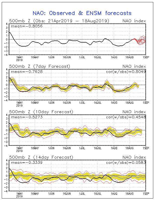
No sign of the NAO going to positive as we head towards the peak weeks of the season. If anything looks to be going more negative. If the NAO stays negative, there is a decent chance troughiness will be around along the eastern seaboard as has been much of the case this summer which in turn could steer any hurricanes away from the US east coast:

Image
1 likes   

User avatar
DioBrando
Category 4
Category 4
Posts: 904
Age: 28
Joined: Sun Aug 12, 2018 12:45 pm

Re: 2019 Indicators: SST'S / Sal / MSLP / Steering / Shear / Instability (See updated graphics at first post)

#979 Postby DioBrando » Sun Aug 18, 2019 12:07 pm

gatorcane wrote:No sign of the NAO going to positive as we head towards the peak weeks of the season. If anything looks to be going more negative. If the NAO stays negative, there is a decent chance troughiness will be around along the eastern seaboard as has been much of the case this summer which in turn could steer any hurricanes away from the US east coast:

https://i.postimg.cc/0jN3TGvs/nao-sprd2.gif

...and a good chance we would see beautiful, harmless category 4 fish storms like Edouard, Gert and Danielle in 2019.
0 likes   
blonde stacey (xe/xem/xir)

User avatar
Hammy
Category 5
Category 5
Posts: 5849
Age: 41
Joined: Fri May 25, 2012 5:25 pm
Contact:

Re: 2019 Indicators: SST'S / Sal / MSLP / Steering / Shear / Instability (See updated graphics at first post)

#980 Postby Hammy » Sun Aug 18, 2019 12:33 pm

psyclone wrote:
DioBrando wrote:Even more season cancel posts but I'm still adamant the gates will open. Even the most optimistic of posters have now turned bearish, and the pessimists keep rehashing the same thing over and over again. Honestly it's improving.

I'm optimistic we will reach at least H or I by the time September ends.


Things will probably pop at some point. 2013 did happen after all so that is possible. The problem is that we always have impatient fans in the stands yelling 2013 every single year. It's the tropical equivalent of "swing, you bum!" Even in slower than normal seasons there are bursts of activity. As for the models showing quiet conditions as far as the eye can see...I don't believe it. It's the opposite of the early season phantom canes we often see...which should also be disregarded. Having said all of that...I was expecting at least some rumblings by now since the bell is about to toll.


While I don't think the number of hurricanes or ACE will be as low as 2013 (we'd have to have literally just one more the rest of the season, and even the quietest long-range models show at least one long-tracking major), the chances of an overall below normal season are rapidly increasing at the moment (though we'll know for sure in another week) and something to keep in mind we're actually running well behind 2013 at the moment--that year had five storms by this point (including three in the MDR)--this year has had zero storms of tropical origin to date. That said, ironically, the last time we went into September with this low of ACE was 1967 though even that year had a few depressions in the deep tropics by this point.

If we do end up having an extremely quiet year though, ironically it seems at the moment the cause would be the polar opposite of 2013--the atmosphere never properly entered winter at the mid and lower latitudes last year, giving the summer pattern an already northward start.
0 likes   
The above post is not official and should not be used as such. It is the opinion of the poster and may or may not be backed by sound meteorological data. It is not endorsed by any professional institution or storm2k.org. For official information, please refer to the NHC and NWS products.


Return to “Talkin' Tropics”

Who is online

Users browsing this forum: KeysRedWine, Stormybajan, Stratton23 and 51 guests