2019 Tropics: Global Model Runs Discussion (Out to day 16)

This is the general tropical discussion area. Anyone can take their shot at predicting a storms path.

Moderator: S2k Moderators

Forum rules

The posts in this forum are NOT official forecasts and should not be used as such. They are just the opinion of the poster and may or may not be backed by sound meteorological data. They are NOT endorsed by any professional institution or STORM2K. For official information, please refer to products from the National Hurricane Center and National Weather Service.

Help Support Storm2K
Message
Author
User avatar
MahFL
Tropical Low
Tropical Low
Posts: 16
Joined: Sat Oct 21, 2017 5:20 am

Re: 2019 Tropics: Global Model Runs Discussion (Out to day 16)

#521 Postby MahFL » Thu Aug 15, 2019 1:50 am

MacTavish wrote:Not sure what everyone is complaining about with the GFS. It has definitely cut back on the number of phantom storms from previous years. Yeah, its catching on to something moving into the gulf region but thats a week out almost.. and obviously no model is going to have the details down at this point in time.


The GFS has been terrible the last couple of weeks.
0 likes   

tolakram
Admin
Admin
Posts: 20010
Age: 62
Joined: Sun Aug 27, 2006 8:23 pm
Location: Florence, KY (name is Mark)

Re: 2019 Tropics: Global Model Runs Discussion (Out to day 16)

#522 Postby tolakram » Thu Aug 15, 2019 6:34 am

MahFL wrote:
MacTavish wrote:Not sure what everyone is complaining about with the GFS. It has definitely cut back on the number of phantom storms from previous years. Yeah, its catching on to something moving into the gulf region but thats a week out almost.. and obviously no model is going to have the details down at this point in time.


The GFS has been terrible the last couple of weeks.


How so? Surface, 500mb, phantom storms?

500mb verification (surface is also available at the link below)

GFS: https://www.wpc.ncep.noaa.gov/html/gfs0012loop500.html

ECMWF: https://www.wpc.ncep.noaa.gov/html/ecmwf0012loop500.html

UKMET: https://www.wpc.ncep.noaa.gov/html/ukmet0012loop500.html

source: https://www.wpc.ncep.noaa.gov/html/model2.shtml#verification
1 likes   
M a r k
- - - - -
Join us in chat: Storm2K Chatroom Invite. Android and IOS apps also available.

The posts in this forum are NOT official forecasts and should not be used as such. Posts are NOT endorsed by any professional institution or STORM2K.org. For official information and forecasts, please refer to NHC and NWS products.

User avatar
cycloneye
Admin
Admin
Posts: 145354
Age: 68
Joined: Thu Oct 10, 2002 10:54 am
Location: San Juan, Puerto Rico

Re: 2019 Tropics: Global Model Runs Discussion (Out to day 16)

#523 Postby cycloneye » Thu Aug 15, 2019 6:36 pm

Is only the first run showing this.

Image
1 likes   
Visit the Caribbean-Central America Weather Thread where you can find at first post web cams,radars
and observations from Caribbean basin members Click Here

User avatar
gatorcane
S2K Supporter
S2K Supporter
Posts: 23691
Age: 47
Joined: Sun Mar 13, 2005 3:54 pm
Location: Boca Raton, FL

Re: 2019 Tropics: Global Model Runs Discussion (Out to day 16)

#524 Postby gatorcane » Thu Aug 15, 2019 8:12 pm

cycloneye wrote:Is only the first run showing this.

https://i.imgur.com/Qwrrkry.gif


Likely a phantom as there is zero support from the ensembles.
0 likes   

User avatar
MahFL
Tropical Low
Tropical Low
Posts: 16
Joined: Sat Oct 21, 2017 5:20 am

Re: 2019 Tropics: Global Model Runs Discussion (Out to day 16)

#525 Postby MahFL » Thu Aug 15, 2019 8:36 pm

tolakram wrote:
MahFL wrote:
MacTavish wrote:Not sure what everyone is complaining about with the GFS. It has definitely cut back on the number of phantom storms from previous years. Yeah, its catching on to something moving into the gulf region but thats a week out almost.. and obviously no model is going to have the details down at this point in time.


The GFS has been terrible the last couple of weeks.


How so? Surface, 500mb, phantom storms?...


500.

Image
0 likes   

USTropics
Professional-Met
Professional-Met
Posts: 2651
Joined: Sun Aug 12, 2007 3:45 am
Location: Florida State University

Re: 2019 Tropics: Global Model Runs Discussion (Out to day 16)

#526 Postby USTropics » Thu Aug 15, 2019 11:38 pm

Looks like the GFS operational is playing catch up with the passing CCKW in the EPAC. Back on board with a developing hurricane in as little as 4 days off of the CA coast. Not great lead time/skill in genesis if this actually comes to fruition:

Image

That being said, this is a great opportunity to show why following the ensembles can be more beneficial to a forecast, where the GEFS has consistently shown development the past 4 runs:
Image
0 likes   

User avatar
Hammy
Category 5
Category 5
Posts: 5849
Age: 41
Joined: Fri May 25, 2012 5:25 pm
Contact:

Re: 2019 Tropics: Global Model Runs Discussion (Out to day 16)

#527 Postby Hammy » Fri Aug 16, 2019 12:25 am

Image
Image

As the GFS continues to be completely useless with showing genesis (either showing things form that won't, or failing to show things that will) it does tend to do well with overall pattern changes, and yet again it's showing the WAM weaken and drop south as we head into September--two notable things here are that the calm area goes from fairly well defined and around 22-24N to being more sharply defined to the south, and along 18-20N--the second being the fairly significant drop in winds over northwest Africa, indicating a marked weakening. GFS will likely start showing an MDR storm at end of run by the end of the weekend given the pattern change, which lines up with where the CFS shows the bursting activity to begin (if it does in fact wait until after August.)
6 likes   
The above post is not official and should not be used as such. It is the opinion of the poster and may or may not be backed by sound meteorological data. It is not endorsed by any professional institution or storm2k.org. For official information, please refer to the NHC and NWS products.

USTropics
Professional-Met
Professional-Met
Posts: 2651
Joined: Sun Aug 12, 2007 3:45 am
Location: Florida State University

Re: 2019 Tropics: Global Model Runs Discussion (Out to day 16)

#528 Postby USTropics » Fri Aug 16, 2019 12:58 am

Hammy wrote:https://i.imgur.com/NRuwhGk.png
https://i.imgur.com/kmckKhA.png

As the GFS continues to be completely useless with showing genesis (either showing things form that won't, or failing to show things that will) it does tend to do well with overall pattern changes, and yet again it's showing the WAM weaken and drop south as we head into September--two notable things here are that the calm area goes from fairly well defined and around 22-24N to being more sharply defined to the south, and along 18-20N--the second being the fairly significant drop in winds over northwest Africa, indicating a marked weakening. GFS will likely start showing an MDR storm at end of run by the end of the weekend given the pattern change, which lines up with where the CFS shows the bursting activity to begin (if it does in fact wait until after August.)


The transitional phase (July/August) is about 3 weeks delayed this year, but seeing the signs of a shift equatorward. A transition from coastal rainfall to more inland/Sahel rainfall coincides with this as well.

Image
3 likes   

User avatar
Blown Away
S2K Supporter
S2K Supporter
Posts: 10146
Joined: Wed May 26, 2004 6:17 am

Re: 2019 Tropics: Global Model Runs Discussion (Out to day 16)

#529 Postby Blown Away » Fri Aug 16, 2019 1:10 pm

GFS long range now into September and shows nothing but a few lows over the Central Atlantic... Wow
2 likes   
Hurricane Eye Experience: David 79, Irene 99, Frances 04, Jeanne 04, Wilma 05... EYE COMING MY WAY IN 2024…
Hurricane Brush Experience: Andrew 92, Erin 95, Floyd 99, Matthew 16, Irma 17, Ian 22, Nicole 22…

User avatar
Hurricaneman
Category 5
Category 5
Posts: 7351
Age: 45
Joined: Tue Aug 31, 2004 3:24 pm
Location: central florida

Re: 2019 Tropics: Global Model Runs Discussion (Out to day 16)

#530 Postby Hurricaneman » Fri Aug 16, 2019 2:01 pm

If anything it looks like the Euro tries to form something in the MDR between day 9 and 10 but it depends on if the MJO is favorable or not but based on models it should be favorable and could show stronger development in future runs
0 likes   

User avatar
gatorcane
S2K Supporter
S2K Supporter
Posts: 23691
Age: 47
Joined: Sun Mar 13, 2005 3:54 pm
Location: Boca Raton, FL

Re: 2019 Tropics: Global Model Runs Discussion (Out to day 16)

#531 Postby gatorcane » Fri Aug 16, 2019 2:21 pm

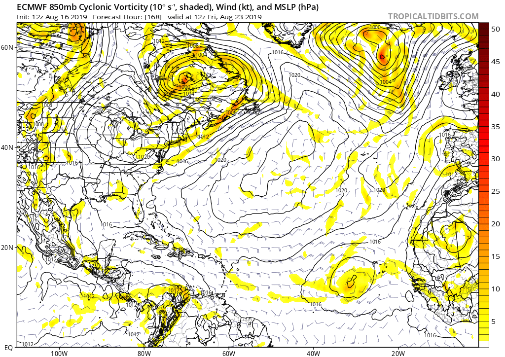
Euro with a broad low over the far eastern Atlantic near the Cape Verde islands. It is now the time of year to start watching for development in that area especially as these lows could find more favorable conditions further west in the area north of the Antilles as the SAL and shear subside:

Image
3 likes   

User avatar
CyclonicFury
Category 5
Category 5
Posts: 2025
Age: 26
Joined: Sun Jul 02, 2017 12:32 pm
Location: NC
Contact:

Re: 2019 Tropics: Global Model Runs Discussion (Out to day 16)

#532 Postby CyclonicFury » Fri Aug 16, 2019 5:05 pm

The 12z EPS has a few members showing some activity in the MDR next week. Sooner or later one of these waves is going to develop.
5 likes   
NCSU B.S. in Meteorology Class of 2021. Tropical weather blogger at http://www.cyclonicfury.com. My forecasts and thoughts are NOT official, for official forecasts please consult the National Hurricane Center.

User avatar
cycloneye
Admin
Admin
Posts: 145354
Age: 68
Joined: Thu Oct 10, 2002 10:54 am
Location: San Juan, Puerto Rico

Re: 2019 Tropics: Global Model Runs Discussion (Out to day 16)

#533 Postby cycloneye » Fri Aug 16, 2019 9:18 pm

0 likes   
Visit the Caribbean-Central America Weather Thread where you can find at first post web cams,radars
and observations from Caribbean basin members Click Here

User avatar
NotSparta
Professional-Met
Professional-Met
Posts: 1670
Age: 23
Joined: Fri Aug 18, 2017 8:24 am
Location: Naples, FL
Contact:

Re: 2019 Tropics: Global Model Runs Discussion (Out to day 16)

#534 Postby NotSparta » Fri Aug 16, 2019 9:46 pm


I wonder what happened to the ensembles :lol:
0 likes   
This post was probably an opinion of mine, and in no way is official. Please refer to http://www.hurricanes.gov for official tropical analysis and advisories.

My website, with lots of tropical wx graphics, including satellite and recon: http://cyclonicwx.com

User avatar
Hammy
Category 5
Category 5
Posts: 5849
Age: 41
Joined: Fri May 25, 2012 5:25 pm
Contact:

Re: 2019 Tropics: Global Model Runs Discussion (Out to day 16)

#535 Postby Hammy » Fri Aug 16, 2019 11:58 pm

GFS starting to develop tropical storms inland over Africa and shooting them NW off of Morocco, which usually is the first indication the model is picking up more favorable conditions
2 likes   
The above post is not official and should not be used as such. It is the opinion of the poster and may or may not be backed by sound meteorological data. It is not endorsed by any professional institution or storm2k.org. For official information, please refer to the NHC and NWS products.

User avatar
Hurricaneman
Category 5
Category 5
Posts: 7351
Age: 45
Joined: Tue Aug 31, 2004 3:24 pm
Location: central florida

Re: 2019 Tropics: Global Model Runs Discussion (Out to day 16)

#536 Postby Hurricaneman » Sat Aug 17, 2019 12:26 am

Hammy wrote:GFS starting to develop tropical storms inland over Africa and shooting them NW off of Morocco, which usually is the first indication the model is picking up more favorable conditions

Id say by the Monday at even mid week runs it will show a good bit of activity
0 likes   

User avatar
crownweather
S2K Supporter
S2K Supporter
Posts: 595
Age: 50
Joined: Sat Aug 12, 2006 9:21 am
Location: Sturbridge, Massachusetts
Contact:

Re: 2019 Tropics: Global Model Runs Discussion (Out to day 16)

#537 Postby crownweather » Sat Aug 17, 2019 6:28 am

EPS model starts waking up the tropics during the last week of this month. Here is the spaghettio chart for 2 weeks from today.

Image
4 likes   
Rob Lightbown
Crown Weather Services
https://crownweather.com

User avatar
gatorcane
S2K Supporter
S2K Supporter
Posts: 23691
Age: 47
Joined: Sun Mar 13, 2005 3:54 pm
Location: Boca Raton, FL

Re: 2019 Tropics: Global Model Runs Discussion (Out to day 16)

#538 Postby gatorcane » Sat Aug 17, 2019 12:34 pm

Today’s 12Z GFS with zilch for two weeks. We will see if the happy hour run later brings something. Even if is is some phantom storm, would be something to talk about at least! #crickets
2 likes   

User avatar
cycloneye
Admin
Admin
Posts: 145354
Age: 68
Joined: Thu Oct 10, 2002 10:54 am
Location: San Juan, Puerto Rico

Re: 2019 Tropics: Global Model Runs Discussion (Out to day 16)

#539 Postby cycloneye » Sat Aug 17, 2019 2:07 pm

12z ECMWF has anything notable thru the 27th.
0 likes   
Visit the Caribbean-Central America Weather Thread where you can find at first post web cams,radars
and observations from Caribbean basin members Click Here

User avatar
NDG
S2K Supporter
S2K Supporter
Posts: 15446
Joined: Sun Jul 09, 2006 10:14 pm
Location: Orlando, FL

Re: 2019 Tropics: Global Model Runs Discussion (Out to day 16)

#540 Postby NDG » Sat Aug 17, 2019 2:15 pm

12z Euro brings back development fom the area of disturbance moving into the GOM currently over the south central Caribbean.

Image
0 likes   


Return to “Talkin' Tropics”

Who is online

Users browsing this forum: Google Adsense [Bot] and 38 guests