2019 Indicators: SST'S / Sal / MSLP / Steering / Shear / Instability (See updated graphics at first post)
Moderator: S2k Moderators
Forum rules

The posts in this forum are NOT official forecasts and should not be used as such. They are just the opinion of the poster and may or may not be backed by sound meteorological data. They are NOT endorsed by any professional institution or STORM2K. For official information, please refer to products from the National Hurricane Center and National Weather Service.
-
NotSparta

- Professional-Met

- Posts: 1677
- Age: 24
- Joined: Fri Aug 18, 2017 8:24 am
- Location: Naples, FL
- Contact:
Re: 2019 Indicators: SST'S / Sal / MSLP / Steering / Shear / Instability (See updated graphics at first post)
The MDR does look quite bad right now, but this is probably the worst it will. Afterwards, the combination of a more favorable CCKW (suppressed is overhead), the rising branch of MJO (there's currently a sinking MJO branch) and climo will lead to a moistening in that region
3 likes
This post was probably an opinion of mine, and in no way is official. Please refer to http://www.hurricanes.gov for official tropical analysis and advisories.
My website, with lots of tropical wx graphics, including satellite and recon: http://cyclonicwx.com
My website, with lots of tropical wx graphics, including satellite and recon: http://cyclonicwx.com


Re: 2019 Indicators: SST'S / Sal / MSLP / Steering / Shear / Instability (See updated graphics at first post)
FINALLY


This looks to be meh-ish to me

And I don't like that cold blob off Africa

Seems to be HORRIBLE here (but again I don't take this model for granted too much as it literally displays July 2020 being in an Ice Age)

NME (not the magazine) also seems to show a cold blob too off the coast of Africa
Now that huge wad of dry air needs to go away
This looks to be meh-ish to me
And I don't like that cold blob off Africa
Seems to be HORRIBLE here (but again I don't take this model for granted too much as it literally displays July 2020 being in an Ice Age)
NME (not the magazine) also seems to show a cold blob too off the coast of Africa
Now that huge wad of dry air needs to go away
0 likes
blonde stacey (xe/xem/xir)
Re: 2019 Indicators: SST'S / Sal / MSLP / Steering / Shear / Instability (See updated graphics at first post)
At the moment as things stand, I would personally see a Chantal and Dorian before the beginning of September, but both being relatively weak.
F/G/H could probably be more intense storms about mid-Sep based on the patterns alone.
F/G/H could probably be more intense storms about mid-Sep based on the patterns alone.
0 likes
blonde stacey (xe/xem/xir)

Re: 2019 Indicators: SST'S / Sal / MSLP / Steering / Shear / Instability (See updated graphics at first post)
DioBrando wrote:NME (not the magazine) also seems to show a cold blob too off the coast of Africa
Now that huge wad of dry air needs to go away
I think the CanSIPS can be tossed, looks like it ingested some bad data and got an extreme cold bias--this is July 2020 for instance.

6 likes
The above post is not official and should not be used as such. It is the opinion of the poster and may or may not be backed by sound meteorological data. It is not endorsed by any professional institution or storm2k.org. For official information, please refer to the NHC and NWS products.
-
Hurricaneman

- Category 5

- Posts: 7404
- Age: 45
- Joined: Tue Aug 31, 2004 3:24 pm
- Location: central florida
Re: 2019 Indicators: SST'S / Sal / MSLP / Steering / Shear / Instability (See updated graphics at first post)
Hammy wrote:DioBrando wrote:NME (not the magazine) also seems to show a cold blob too off the coast of Africa
Now that huge wad of dry air needs to go away
I think the CanSIPS can be tossed, looks like it ingested some bad data and got an extreme cold bias--this is July 2020 for instance.
https://i.imgur.com/ZP6zFmj.png
Looks bugged to me, hopefully the issue is fixed with that model
1 likes
-
USTropics
- Professional-Met
- Posts: 2742
- Joined: Sun Aug 12, 2007 3:45 am
- Location: Florida State University
Re: 2019 Indicators: SST'S / Sal / MSLP / Steering / Shear / Instability (See updated graphics at first post)
Hurricaneman wrote:Hammy wrote:DioBrando wrote:NME (not the magazine) also seems to show a cold blob too off the coast of Africa
Now that huge wad of dry air needs to go away
I think the CanSIPS can be tossed, looks like it ingested some bad data and got an extreme cold bias--this is July 2020 for instance.
https://i.imgur.com/ZP6zFmj.png
Looks bugged to me, hopefully the issue is fixed with that model
Yea, definitely a bad run:
https://twitter.com/MJVentrice/status/1157019820807917568
2 likes

Re: 2019 Indicators: SST'S / Sal / MSLP / Steering / Shear / Instability (See updated graphics at first post)
Emmett_Brown wrote:Not to be an alarmist, but the long range pattern is getting a little more concerning for land areas in the W NATL basin should something develop. Here are the ingredients that could cause trouble as we get toward the peak in a few weeks:
- Stable air and marginal SSTs in the MDR preventing immediate genesis/recurvature... waves will likely get further W before developing
- Above average SST's in the Caribbean, GOM and W ATL
- Below average Caribbean shear
- Further W extension of the Bermuda High
- A return of vertical instability in W ATL basin late Aug, thru early Sept
- Nino has ended, and activity in the WPac, CPac and EPac has been near normal or a little below average ACE wise
While these conditions are not guaranteed to materialize, and if they do, storms are not guaranteed, the writing is certainly on the wall that our quiet conditions could be ending soon, and when the switch flips, whatever forms may find its way close to land. I have noticed in years past that when conditions are quiet in August, the peak in September thru October can be particularly busy. Just my personal observation.
The only variable (above) that I'm not sure how to justify might be regarding how/why the Western extension of the Bermuda high may be anticipated to build and/or shift more to the west with time. It certainly may, but the pattern thus far would generally seem to suggest that storm tracks would tend to move along and parallel the U.S. Conus or move NNE. Granted, if we were to begin to see evidence of westward building 500mb heights, then I'd agree that this could be foreboding (especially with a number of storm formations potentially to form out of the MDR and closer to P.R. or north of the Greater Antilles. For now though and until I begin to see evidence of dryer air abating and a more westward steering evolve, I have to think that the point of cyclogenesis that might pose the greatest risk to the CONUS could potentially be the Central or Western Caribbean sometime between mid Sept. and mid October. Conditions could well change in 2-3 weeks but i'll need a bit more evidence before jumping on that bandwagon.
2 likes
Andy D
(For official information, please refer to the NHC and NWS products.)
(For official information, please refer to the NHC and NWS products.)
-
USTropics
- Professional-Met
- Posts: 2742
- Joined: Sun Aug 12, 2007 3:45 am
- Location: Florida State University
Re: 2019 Indicators: SST'S / Sal / MSLP / Steering / Shear / Instability (See updated graphics at first post)
chaser1 wrote:Emmett_Brown wrote:Not to be an alarmist, but the long range pattern is getting a little more concerning for land areas in the W NATL basin should something develop. Here are the ingredients that could cause trouble as we get toward the peak in a few weeks:
- Stable air and marginal SSTs in the MDR preventing immediate genesis/recurvature... waves will likely get further W before developing
- Above average SST's in the Caribbean, GOM and W ATL
- Below average Caribbean shear
- Further W extension of the Bermuda High
- A return of vertical instability in W ATL basin late Aug, thru early Sept
- Nino has ended, and activity in the WPac, CPac and EPac has been near normal or a little below average ACE wise
While these conditions are not guaranteed to materialize, and if they do, storms are not guaranteed, the writing is certainly on the wall that our quiet conditions could be ending soon, and when the switch flips, whatever forms may find its way close to land. I have noticed in years past that when conditions are quiet in August, the peak in September thru October can be particularly busy. Just my personal observation.
The only variable (above) that I'm not sure how to justify might be regarding how/why the Western extension of the Bermuda high may be anticipated to build and/or shift more to the west with time. It certainly may, but the pattern thus far would generally seem to suggest that storm tracks would tend to move along and parallel the U.S. Conus or move NNE. Granted, if we were to begin to see evidence of westward building 500mb heights, then I'd agree that this could be foreboding (especially with a number of storm formations potentially to form out of the MDR and closer to P.R. or north of the Greater Antilles. For now though and until I begin to see evidence of dryer air abating and a more westward steering evolve, I have to think that the point of cyclogenesis that might pose the greatest risk to the CONUS could potentially be the Central or Western Caribbean sometime between mid Sept. and mid October. Conditions could well change in 2-3 weeks but i'll need a bit more evidence before jumping on that bandwagon.
Never a guarantee, but the long-range models/weekly CFS have been hinting at this. Instead of eroding the western peripheries of the high pressure area or getting blocked, the next few shortwave troughs will be higher in latitude and past to the north, amplifying/shoving the subtropical ridge westward:

1 likes
-
SFLcane

- S2K Supporter

- Posts: 10281
- Age: 48
- Joined: Sat Jun 05, 2010 1:44 pm
- Location: Lake Worth Florida
Re: 2019 Indicators: SST'S / Sal / MSLP / Steering / Shear / Instability (See updated graphics at first post)
Ok this would be a big problem if there was something out there to take advantage of it. Not much on the models thankfully

1 likes
-
tropicwatch

- Category 5
- Posts: 3427
- Age: 62
- Joined: Sat Jun 02, 2007 10:01 am
- Location: The Villages, Florida
- Contact:
Re: 2019 Indicators: SST'S / Sal / MSLP / Steering / Shear / Instability (See updated graphics at first post)
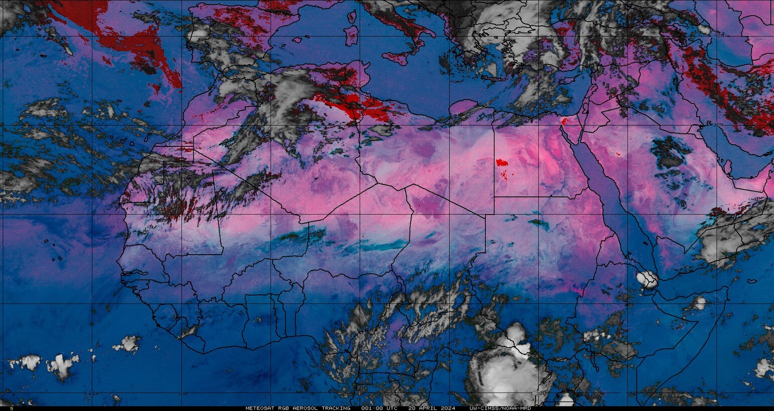
Looking at the TPW loop, it appears something unusual is going on in west Africa. Not seeing the westward progression of precipitation.
http://tropic.ssec.wisc.edu/real-time/mtpw2/webAnims/tpw_nrl_colors/natl/mimictpw_natl_latest.gif
http://tropic.ssec.wisc.edu/real-time/mtpw2/webAnims/tpw_nrl_colors/natl/mimictpw_natl_latest.gif
1 likes
Tropicwatch
Agnes 72', Eloise 75, Elena 85', Kate 85', Charley 86', Florence 88', Beryl 94', Dean 95', Erin 95', Opal 95', Earl 98', Georges 98', Ivan 2004', Arlene 2005', Dennis 2005', Ida 2009' Debby 2012' Irma 2017' Michael 2018'
Agnes 72', Eloise 75, Elena 85', Kate 85', Charley 86', Florence 88', Beryl 94', Dean 95', Erin 95', Opal 95', Earl 98', Georges 98', Ivan 2004', Arlene 2005', Dennis 2005', Ida 2009' Debby 2012' Irma 2017' Michael 2018'
Re: 2019 Indicators: SST'S / Sal / MSLP / Steering / Shear / Instability (See updated graphics at first post)
panamatropicwatch wrote:Looking at the TPW loop, it appears something unusual is going on in west Africa. Not seeing the westward progression of precipitation.
http://tropic.ssec.wisc.edu/real-time/mtpw2/webAnims/tpw_nrl_colors/natl/mimictpw_natl_latest.gif
Monsoon trough seems to be around 22-24N so looks like low-level westerlies to the south.
1 likes
The above post is not official and should not be used as such. It is the opinion of the poster and may or may not be backed by sound meteorological data. It is not endorsed by any professional institution or storm2k.org. For official information, please refer to the NHC and NWS products.
-
cycloneye

- Admin

- Posts: 149753
- Age: 69
- Joined: Thu Oct 10, 2002 10:54 am
- Location: San Juan, Puerto Rico
Re: 2019 Indicators: SST'S / Sal / MSLP / Steering / Shear / Instability (See updated graphics at first post)
2 likes
Visit the Caribbean-Central America Weather Thread where you can find at first post web cams,radars
and observations from Caribbean basin members Click Here
and observations from Caribbean basin members Click Here
-
cycloneye
- Admin
- Posts: 149753
- Age: 69
- Joined: Thu Oct 10, 2002 10:54 am
- Location: San Juan, Puerto Rico
Re: 2019 Indicators: SST'S / Sal / MSLP / Steering / Shear / Instability (See updated graphics at first post)
0 likes
Visit the Caribbean-Central America Weather Thread where you can find at first post web cams,radars
and observations from Caribbean basin members Click Here
and observations from Caribbean basin members Click Here

Re: 2019 Indicators: SST'S / Sal / MSLP / Steering / Shear / Instability (See updated graphics at first post)
Once subsidence settles down I think this season not only will it be active in September it will go well into October with activity, IMO
3 likes
Re: 2019 Indicators: SST'S / Sal / MSLP / Steering / Shear / Instability (See updated graphics at first post)
cycloneye wrote:The timeframe keeps moving ahead.
https://twitter.com/AndyHazelton/status/1160899966283345921
Just in time for the TW exiting Africa to reach the western basin with rising motion moving in.
1 likes

Re: 2019 Indicators: SST'S / Sal / MSLP / Steering / Shear / Instability (See updated graphics at first post)
Camille hit on August 17th in 1969. That's pretty much early in the season. I know I'll never forget that night.
0 likes
-
TheStormExpert
Re: 2019 Indicators: SST'S / Sal / MSLP / Steering / Shear / Instability (See updated graphics at first post)
Wouldn’t last year resembled 1969 a little better with Hurricane Michael?
0 likes
Re: 2019 Indicators: SST'S / Sal / MSLP / Steering / Shear / Instability (See updated graphics at first post)
at least we're getting somewhere

and that huge wad of shear over america is expected to clear off based on the previous graph too

the main problem now is dry air

once the waves start propagating, they'll clear things up.
and that huge wad of shear over america is expected to clear off based on the previous graph too
the main problem now is dry air
once the waves start propagating, they'll clear things up.
2 likes
blonde stacey (xe/xem/xir)
-
CyclonicFury

- Category 5
- Posts: 2038
- Age: 27
- Joined: Sun Jul 02, 2017 12:32 pm
- Location: NC
- Contact:
Re: 2019 Indicators: SST'S / Sal / MSLP / Steering / Shear / Instability (See updated graphics at first post)
The Atlantic looks dead right now, but this basin can turn active in a flash in mid-late August. Every year around this time the discussion is usually the same. SAL, dry air in the MDR, nothing on the models, etc. Then climatology kicks in and by the last day of August you're usually tracking something with more systems on the models.
Rule #1 of the tropics: Never season cancel before August 20.
Rule #1 of the tropics: Never season cancel before August 20.
7 likes
NCSU B.S. in Meteorology Class of 2021. Tropical weather blogger at http://www.cyclonicfury.com. My forecasts and thoughts are NOT official, for official forecasts please consult the National Hurricane Center.
Who is online
Users browsing this forum: pepecool20 and 156 guests