Watching GOM for tropical development (Is INVEST 92L)
Moderator: S2k Moderators
Forum rules

The posts in this forum are NOT official forecasts and should not be used as such. They are just the opinion of the poster and may or may not be backed by sound meteorological data. They are NOT endorsed by any professional institution or STORM2K. For official information, please refer to products from the National Hurricane Center and National Weather Service.
Re: Watching NE GOM for tropical development
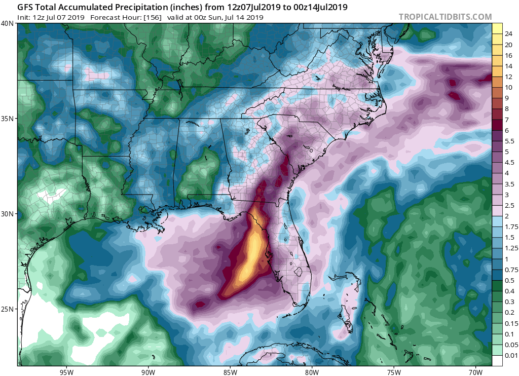
I would lean toward a right loaded QPF bomb with most of the rain dumping on florida. Most of these systems end up weak and right and that's what is probably most likely here. If it shakes out that way it will tame the extremely warm water temps in our part of the world which is usually what eventually happens when they get out of bounds.
0 likes

Re: Watching Northern GOM for tropical development
northjaxpro wrote:Also, to complicate matters further, the potential system could get stuck in a COL, an area of weak steering, for much of this upcoming week. This system indeed could meander around in Apalachee Bay /Northeast GOM region for most of the week. Could see flood potential for some areas as the week progresses
Complex situation. It is quite possible this system may not get far enough south into the GOM to develop. The vorticity could be so elongated in which it can not consolidate a center and also due to land proximity. Lots to look for in the next couple of days for sure!
This very same thing happened in August 2016. Southern Louisiana got hammered with rain. Over 100K homes flooded, including mine. I pray for this vorticity to take a hike and head on out to the Atlantic. No one deserves a flooded home.
1 likes
-
Aric Dunn
- Category 5

- Posts: 21238
- Age: 43
- Joined: Sun Sep 19, 2004 9:58 pm
- Location: Ready for the Chase.
- Contact:
Re: Watching NE GOM for tropical development
psyclone wrote:I would lean toward a right loaded QPF bomb with most of the rain dumping on florida. Most of these systems end up weak and right and that's what is probably most likely here. If it shakes out that way it will tame the extremely warm water temps in our part of the world which is usually what eventually happens when they get out of bounds.
unfortunately that requires strong SW shear. we dont have that in the case.
0 likes
Note: If I make a post that is brief. Please refer back to previous posts for the analysis or reasoning. I do not re-write/qoute what my initial post said each time.
If there is nothing before... then just ask
Space & Atmospheric Physicist, Embry-Riddle Aeronautical University,
I believe the sky is falling...
If there is nothing before... then just ask
Space & Atmospheric Physicist, Embry-Riddle Aeronautical University,
I believe the sky is falling...
-
Hurricaneman

- Category 5
- Posts: 7404
- Age: 45
- Joined: Tue Aug 31, 2004 3:24 pm
- Location: central florida
Re: Watching NE GOM for tropical development
The 12zGFS shows landfall as a 1002mb TS Friday in the big bend of Florida
0 likes


Re: Watching NE GOM for tropical development
12z UKMET:
NEW TROPICAL CYCLONE FORECAST TO DEVELOP AFTER 114 HOURS
FORECAST POSITION AT T+114 : 27.1N 86.3W
LEAD CENTRAL MAXIMUM WIND
VERIFYING TIME TIME POSITION PRESSURE (MB) SPEED (KNOTS)
-------------- ---- -------- ------------- -------------
1200UTC 12.07.2019 120 27.8N 86.1W 1003 40
0000UTC 13.07.2019 132 28.2N 86.2W 997 40
1200UTC 13.07.2019 144 29.4N 86.0W 991 58
0 likes
-
Aric Dunn
- Category 5
- Posts: 21238
- Age: 43
- Joined: Sun Sep 19, 2004 9:58 pm
- Location: Ready for the Chase.
- Contact:
Re: Watching NE GOM for tropical development
Hurricaneman wrote:The 12zGFS shows landfall as a 1002mb TS Friday in the big bend of Florida
it also shows numerous center reformations.. so not much we can take out of it except the synoptic set up.
0 likes
Note: If I make a post that is brief. Please refer back to previous posts for the analysis or reasoning. I do not re-write/qoute what my initial post said each time.
If there is nothing before... then just ask
Space & Atmospheric Physicist, Embry-Riddle Aeronautical University,
I believe the sky is falling...
If there is nothing before... then just ask
Space & Atmospheric Physicist, Embry-Riddle Aeronautical University,
I believe the sky is falling...

Re: Watching NE GOM for tropical development
12z GFS is a little stronger but it still persistent with its track back up towards FL's big bend area Friday morning.

0 likes
Re: Watching NE GOM for tropical development
stormlover2013 wrote:Where does Ukmet show ?
Moving north towards PCB area at end of run.
0 likes
-
ColdMiser123

- Professional-Met

- Posts: 905
- Age: 29
- Joined: Mon Sep 26, 2016 3:26 pm
- Location: Northeast US
Re: Watching NE GOM for tropical development
UK is still offshore at the last set of coordinates at 144 hours.
NEW TROPICAL CYCLONE FORECAST TO DEVELOP AFTER 114 HOURS
FORECAST POSITION AT T+114 : 27.1N 86.3W
LEAD CENTRAL MAXIMUM WIND
VERIFYING TIME TIME POSITION PRESSURE (MB) SPEED (KNOTS)
-------------- ---- -------- ------------- -------------
1200UTC 12.07.2019 120 27.8N 86.1W 1003 40
0000UTC 13.07.2019 132 28.2N 86.2W 997 40
1200UTC 13.07.2019 144 29.4N 86.0W 991 58
0 likes
B.S., M.S., Meteorology & Atmospheric Science
-
Aric Dunn
- Category 5
- Posts: 21238
- Age: 43
- Joined: Sun Sep 19, 2004 9:58 pm
- Location: Ready for the Chase.
- Contact:
Re: Watching NE GOM for tropical development
ColdMiser123 wrote:UK is still offshore at the last set of coordinates at 144 hours.
NEW TROPICAL CYCLONE FORECAST TO DEVELOP AFTER 114 HOURS
FORECAST POSITION AT T+114 : 27.1N 86.3W
LEAD CENTRAL MAXIMUM WIND
VERIFYING TIME TIME POSITION PRESSURE (MB) SPEED (KNOTS)
-------------- ---- -------- ------------- -------------
1200UTC 12.07.2019 120 27.8N 86.1W 1003 40
0000UTC 13.07.2019 132 28.2N 86.2W 997 40
1200UTC 13.07.2019 144 29.4N 86.0W 991 58
that is 12 mb stronger than the 00z run..
and much farther west.
0 likes
Note: If I make a post that is brief. Please refer back to previous posts for the analysis or reasoning. I do not re-write/qoute what my initial post said each time.
If there is nothing before... then just ask
Space & Atmospheric Physicist, Embry-Riddle Aeronautical University,
I believe the sky is falling...
If there is nothing before... then just ask
Space & Atmospheric Physicist, Embry-Riddle Aeronautical University,
I believe the sky is falling...
-
ColdMiser123
- Professional-Met
- Posts: 905
- Age: 29
- Joined: Mon Sep 26, 2016 3:26 pm
- Location: Northeast US
Re: Watching NE GOM for tropical development
Aric Dunn wrote:ColdMiser123 wrote:UK is still offshore at the last set of coordinates at 144 hours.
NEW TROPICAL CYCLONE FORECAST TO DEVELOP AFTER 114 HOURS
FORECAST POSITION AT T+114 : 27.1N 86.3W
LEAD CENTRAL MAXIMUM WIND
VERIFYING TIME TIME POSITION PRESSURE (MB) SPEED (KNOTS)
-------------- ---- -------- ------------- -------------
1200UTC 12.07.2019 120 27.8N 86.1W 1003 40
0000UTC 13.07.2019 132 28.2N 86.2W 997 40
1200UTC 13.07.2019 144 29.4N 86.0W 991 58
that is 12 mb stronger than the 00z run..
That is also closer to the Euro progression. GFS is already well inland at that time while the Euro is still offshore.
0 likes
B.S., M.S., Meteorology & Atmospheric Science
-
ColdMiser123
- Professional-Met
- Posts: 905
- Age: 29
- Joined: Mon Sep 26, 2016 3:26 pm
- Location: Northeast US
Re: Watching NE GOM for tropical development
Canadian seems pretty close to the GFS looking at the coarse resolution WSI maps.
0 likes
B.S., M.S., Meteorology & Atmospheric Science
-
Aric Dunn
- Category 5
- Posts: 21238
- Age: 43
- Joined: Sun Sep 19, 2004 9:58 pm
- Location: Ready for the Chase.
- Contact:
Re: Watching NE GOM for tropical development
ColdMiser123 wrote:Canadian seems pretty close to the GFS looking at the coarse resolution WSI maps.
also has a bunch of reformations. but it is drifting west at 90 hrs.
0 likes
Note: If I make a post that is brief. Please refer back to previous posts for the analysis or reasoning. I do not re-write/qoute what my initial post said each time.
If there is nothing before... then just ask
Space & Atmospheric Physicist, Embry-Riddle Aeronautical University,
I believe the sky is falling...
If there is nothing before... then just ask
Space & Atmospheric Physicist, Embry-Riddle Aeronautical University,
I believe the sky is falling...
-
ColdMiser123
- Professional-Met
- Posts: 905
- Age: 29
- Joined: Mon Sep 26, 2016 3:26 pm
- Location: Northeast US
Re: Watching NE GOM for tropical development
UK maps with 500 hPa height anomalies should be available on TrueWx within an hour.
0 likes
B.S., M.S., Meteorology & Atmospheric Science
-
gatorcane

- S2K Supporter

- Posts: 23703
- Age: 47
- Joined: Sun Mar 13, 2005 3:54 pm
- Location: Boca Raton, FL
Re: Watching NE GOM for tropical development
psyclone wrote:I would lean toward a right loaded QPF bomb with most of the rain dumping on florida. Most of these systems end up weak and right and that's what is probably most likely here. If it shakes out that way it will tame the extremely warm water temps in our part of the world which is usually what eventually happens when they get out of bounds.
Yep a right loaded QPF bomb looks likely. Latest GFS has that QPF swath (20+ inches of rain
1 likes
-
stormlover2013
Re: Watching NE GOM for tropical development
Aric Dunn wrote:ColdMiser123 wrote:Canadian seems pretty close to the GFS looking at the coarse resolution WSI maps.
also has a bunch of reformations. but it is drifting west at 90 hrs.
Lol poor cmc and gfs lol, I mean let’s be honest here cmc is usually 98 percent wrong, if euro shows same thing again I’m sticking with euro
2 likes
-
Aric Dunn
- Category 5
- Posts: 21238
- Age: 43
- Joined: Sun Sep 19, 2004 9:58 pm
- Location: Ready for the Chase.
- Contact:
Re: Watching NE GOM for tropical development
Big change in thinking from the UKMET. it even exits the coast farther west. very interesting. and actually, this is a very reasonable solution.

1 likes
Note: If I make a post that is brief. Please refer back to previous posts for the analysis or reasoning. I do not re-write/qoute what my initial post said each time.
If there is nothing before... then just ask
Space & Atmospheric Physicist, Embry-Riddle Aeronautical University,
I believe the sky is falling...
If there is nothing before... then just ask
Space & Atmospheric Physicist, Embry-Riddle Aeronautical University,
I believe the sky is falling...

Re: Watching NE GOM for tropical development
Latest CIMSS analysis showing a strengthening 850mb vort on the GA / AL Border.
Can see a spin on MIMIC TPW
http://tropic.ssec.wisc.edu/real-time/m ... anim=html5
12Z GFS seems to be underestimating it at 000.


Can see a spin on MIMIC TPW
http://tropic.ssec.wisc.edu/real-time/m ... anim=html5
12Z GFS seems to be underestimating it at 000.
2 likes
-
stormlover2013
Re: Watching NE GOM for tropical development
Aric Dunn wrote:Big change in thinking from the UKMET. it even exits the coast farther west. very interesting. and actually, this is a very reasonable solution.
https://i.ibb.co/g9kL0gN/UKMET-17-km-Gulf-of-Mexico-MSLP-1.gif
Aric, I like the euro and icon right now and ukmet will get in line
0 likes
Who is online
Users browsing this forum: cycloneye and 64 guests