2019 Indicators: SST'S / Sal / MSLP / Steering / Shear / Instability (See updated graphics at first post)

This is the general tropical discussion area. Anyone can take their shot at predicting a storms path.

Moderator: S2k Moderators

Forum rules

The posts in this forum are NOT official forecasts and should not be used as such. They are just the opinion of the poster and may or may not be backed by sound meteorological data. They are NOT endorsed by any professional institution or STORM2K. For official information, please refer to products from the National Hurricane Center and National Weather Service.

Help Support Storm2K
Message
Author
User avatar
NotSparta
Professional-Met
Professional-Met
Posts: 1671
Age: 23
Joined: Fri Aug 18, 2017 8:24 am
Location: Naples, FL
Contact:

Re: 2019 Indicators: SST'S / Sal / MSLP / Steering / Shear / Instability (See updated graphics at first post)

#361 Postby NotSparta » Thu Jun 27, 2019 7:43 pm

BYG Jacob wrote: Looks like neutral or Nina this year.


Will be difficult to swing all the way to La Niña this yr, but neutral looks pretty likely
1 likes   
This post was probably an opinion of mine, and in no way is official. Please refer to http://www.hurricanes.gov for official tropical analysis and advisories.

My website, with lots of tropical wx graphics, including satellite and recon: http://cyclonicwx.com

User avatar
crownweather
S2K Supporter
S2K Supporter
Posts: 595
Age: 50
Joined: Sat Aug 12, 2006 9:21 am
Location: Sturbridge, Massachusetts
Contact:

Re: 2019 Indicators: SST'S / Sal / MSLP / Steering / Shear / Instability (See updated graphics at first post)

#362 Postby crownweather » Thu Jun 27, 2019 7:58 pm

NotSparta wrote:
BYG Jacob wrote: Looks like neutral or Nina this year.


Will be difficult to swing all the way to La Niña this yr, but neutral looks pretty likely


Much different than what the ENSO models showed back in late Winter and early Spring. While I didn't buy into the full-blown El Nino forecast by the ECMWF, I did think that at least a weak El NIno was probable during the Hurricane Season. Now, I'm not so sure of that and like you, I think a warm neutral seems pretty probable now.
1 likes   
Rob Lightbown
Crown Weather Services
https://crownweather.com

User avatar
gatorcane
S2K Supporter
S2K Supporter
Posts: 23691
Age: 47
Joined: Sun Mar 13, 2005 3:54 pm
Location: Boca Raton, FL

Re: 2019 Indicators: SST'S / Sal / MSLP / Steering / Shear / Instability (See updated graphics at first post)

#363 Postby gatorcane » Thu Jun 27, 2019 8:08 pm

Pretty warm anomalies everywhere in this image especially around Florida and the Bahamas. This setup suggests there may be above average activity yet again for this region.


Image
0 likes   

TheStormExpert

Re: 2019 Indicators: SST'S / Sal / MSLP / Steering / Shear / Instability (See updated graphics at first post)

#364 Postby TheStormExpert » Thu Jun 27, 2019 10:04 pm

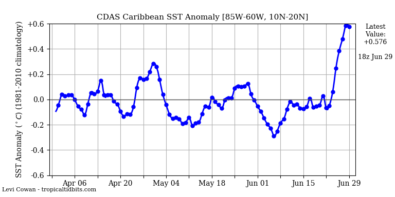
gatorcane wrote:Pretty warm anomalies everywhere in this image especially around Florida and the Bahamas. This setup suggests there may be above average activity yet again for this region.


https://i.postimg.cc/KcH4vZnd/anoma-6-27-2019.gif

SST's just off Andros Island in the NW Bahamas are quickly approaching 90ºF! If anything were to tap into this region you'd better watch out! :eek:

Image
1 likes   

Chris90
Category 2
Category 2
Posts: 646
Age: 35
Joined: Thu Jun 01, 2017 9:36 pm

Re: 2019 Indicators: SST'S / Sal / MSLP / Steering / Shear / Instability (See updated graphics at first post)

#365 Postby Chris90 » Fri Jun 28, 2019 3:49 am

Regarding the state of ENSO in relation to its potential effects on the ATL season, especially as we draw ever closer to peak season, I think it's important to consider ENSO trend just as much if not more so than what the official ENSO state will be during peak season. I think sometimes people get into the mind state of "La Nina=above average and El Nino=below average" and so they focus on what the official ENSO state will be during peak season. 2005 and 2017 were not official Ninas right off the bat, they trended that way until the trimonthlies officially reflected a Nina.

In 2005, the JJA (June-July-August) trimontly was -0.1. It stayed -0.1 for the next two trimonthlies of JAS and ASO. The La Nina threshold wasn't reached until OND (October-November-December) with a value of -0.6. Activity in 2005 kicked off right at the start and produced 2 majors in July.

2017 was still at warm neutral in JJA as it was trending down and reached Nina threshold in SON with a value of -0.7. Just a quick note, 2017 trended towards Nina faster than 2005 did and ended up peaking stronger than 2005, reaching a value of -1.0, but that season also died off faster than 2005. It really geared up in August with Harvey and produced that prolific and monstrous September, but it didn't continue to produce through October-December nearly the same way 2005 did. 2005 produced a lot more consistently from the very beginning of the season all the way through December, whereas 2017 had a very noticeable peak in August and September. I believe, I may be wrong, but I think September 2017 set a monthly ACE record of something like 175.

So maybe 2005 with the slower and steadier trend downwards to Nina managed to produce a lot more consistently throughout the entire season as opposed to 2017 which trended downwards to Nina faster, but resulted in a very noticeable, but much shorter, peak.

I'm not saying that this automatically means we're doomed to experience another 2005 or 2017, there's many other factors that go into a season. But I do think in regards to ENSO it is a bit of a concerning indicator that we're trending downwards away from Nino, and it doesn't seem to be falling exceptionally fast, it's been a fairly leisurely pace downwards, especially with the conflicting signals there have been recently, which indicates to me it may continue to be a slow trend cooler. So maybe when the lid comes off it'll be a season that consistently produces through the end of November 30th. It's concerning to me that this slow trend cooler is combined with a warming ATL and a very strong WAM. I'm starting to feel a bit more confident in my contest numbers of 16/9/5 than I was before. Hopefully I'm wrong.
2 likes   
Solar Aquarian
Lunar Cancerian
:uarrow: Sagittarian

tolakram
Admin
Admin
Posts: 20010
Age: 62
Joined: Sun Aug 27, 2006 8:23 pm
Location: Florence, KY (name is Mark)

Re: 2019 Indicators: SST'S / Sal / MSLP / Steering / Shear / Instability (See updated graphics at first post)

#366 Postby tolakram » Fri Jun 28, 2019 6:21 am

Here's May 2nd, May 30th, annd June 27th SST anomalies animated.

Image
2 likes   
M a r k
- - - - -
Join us in chat: Storm2K Chatroom Invite. Android and IOS apps also available.

The posts in this forum are NOT official forecasts and should not be used as such. Posts are NOT endorsed by any professional institution or STORM2K.org. For official information and forecasts, please refer to NHC and NWS products.

User avatar
SFLcane
S2K Supporter
S2K Supporter
Posts: 10163
Age: 47
Joined: Sat Jun 05, 2010 1:44 pm
Location: Lake Worth Florida

Re: 2019 Indicators: SST'S / Sal / MSLP / Steering / Shear / Instability (See updated graphics at first post)

#367 Postby SFLcane » Fri Jun 28, 2019 7:01 am

3 likes   

User avatar
SFLcane
S2K Supporter
S2K Supporter
Posts: 10163
Age: 47
Joined: Sat Jun 05, 2010 1:44 pm
Location: Lake Worth Florida

Re: 2019 Indicators: SST'S / Sal / MSLP / Steering / Shear / Instability (See updated graphics at first post)

#368 Postby SFLcane » Fri Jun 28, 2019 7:03 am

3 likes   

User avatar
SFLcane
S2K Supporter
S2K Supporter
Posts: 10163
Age: 47
Joined: Sat Jun 05, 2010 1:44 pm
Location: Lake Worth Florida

Re: 2019 Indicators: SST'S / Sal / MSLP / Steering / Shear / Instability (See updated graphics at first post)

#369 Postby SFLcane » Fri Jun 28, 2019 1:54 pm

Explosive potential after 60w ... :eek:

Image
2 likes   

User avatar
NotSparta
Professional-Met
Professional-Met
Posts: 1671
Age: 23
Joined: Fri Aug 18, 2017 8:24 am
Location: Naples, FL
Contact:

Re: 2019 Indicators: SST'S / Sal / MSLP / Steering / Shear / Instability (See updated graphics at first post)

#370 Postby NotSparta » Fri Jun 28, 2019 2:43 pm

SFLcane wrote:Explosive potential after 60w ... :eek:

http://i66.tinypic.com/30accr4.gif


Note how much less there is in the MDR, good if the Caribbean is ruled by shear again
0 likes   
This post was probably an opinion of mine, and in no way is official. Please refer to http://www.hurricanes.gov for official tropical analysis and advisories.

My website, with lots of tropical wx graphics, including satellite and recon: http://cyclonicwx.com

User avatar
Kingarabian
S2K Supporter
S2K Supporter
Posts: 15981
Joined: Sat Aug 08, 2009 3:06 am
Location: Honolulu, Hawaii

Re: 2019 Indicators: SST'S / Sal / MSLP / Steering / Shear / Instability (See updated graphics at first post)

#371 Postby Kingarabian » Fri Jun 28, 2019 2:49 pm

NotSparta wrote:
SFLcane wrote:Explosive potential after 60w ... :eek:

http://i66.tinypic.com/30accr4.gif


Note how much less there is in the MDR, good if the Caribbean is ruled by shear again

I think if shear is low enough, it'll still be able to support a strong low rider with relative ease.
3 likes   
RIP Kobe Bryant

User avatar
NotSparta
Professional-Met
Professional-Met
Posts: 1671
Age: 23
Joined: Fri Aug 18, 2017 8:24 am
Location: Naples, FL
Contact:

Re: 2019 Indicators: SST'S / Sal / MSLP / Steering / Shear / Instability (See updated graphics at first post)

#372 Postby NotSparta » Fri Jun 28, 2019 4:10 pm

Kingarabian wrote:
NotSparta wrote:
SFLcane wrote:Explosive potential after 60w ... :eek:

http://i66.tinypic.com/30accr4.gif


Note how much less there is in the MDR, good if the Caribbean is ruled by shear again

I think if shear is low enough, it'll still be able to support a strong low rider with relative ease.


Yeah the MDR doesn't look bad, SST is decent and will likely rise owing to the WAM (usually the monsoon zone will become very warm at the end of August).

However not sure how to feel about the Caribbean. I'm not confident shear will be low there. ENSO doesn't look strong enough to be a big effect on the Caribbean shear (especially further east where it's important), but the big wild card is where the EPAC/CPAC season is biggest. It's definitely looking like another big season out there, but where the convection/TCs set up will be crucial. More CPAC based, then the EPAC is less active and shear is lowered in the Caribbean, which would allow low riders thru there. Then if the activity is east, then it's like last yr where storms can thrive in the MDR but begin getting shredded near 60°W.

We shall see what happens though, hopefully the Atlantic ridge is on the weaker side since it's been quite a few bad seasons there now
5 likes   
This post was probably an opinion of mine, and in no way is official. Please refer to http://www.hurricanes.gov for official tropical analysis and advisories.

My website, with lots of tropical wx graphics, including satellite and recon: http://cyclonicwx.com

User avatar
gatorcane
S2K Supporter
S2K Supporter
Posts: 23691
Age: 47
Joined: Sun Mar 13, 2005 3:54 pm
Location: Boca Raton, FL

Re: 2019 Indicators: SST'S / Sal / MSLP / Steering / Shear / Instability (See updated graphics at first post)

#373 Postby gatorcane » Fri Jun 28, 2019 9:30 pm

Even if we didn't fade to neutral, I doubt we had enough NINO to stifle the season & its influence was overrated in many seasonal forecasts imo. There were other variables that suggested this year wouldn't be quiet. Maybe it still is somehow (i.e. 2013) but that seems unlikely

-- Eric Webb (@webberweather) June 28, 2019


The EPAC was also relatively quiet in 2013 and that doesn’t look to be the case looking at the next 7-10 days and possibly beyond. So I agree unlikely this year will be another 2013 for the Atlantic.
1 likes   

User avatar
NotSparta
Professional-Met
Professional-Met
Posts: 1671
Age: 23
Joined: Fri Aug 18, 2017 8:24 am
Location: Naples, FL
Contact:

Re: 2019 Indicators: SST'S / Sal / MSLP / Steering / Shear / Instability (See updated graphics at first post)

#374 Postby NotSparta » Fri Jun 28, 2019 9:51 pm

gatorcane wrote:
Even if we didn't fade to neutral, I doubt we had enough NINO to stifle the season & its influence was overrated in many seasonal forecasts imo. There were other variables that suggested this year wouldn't be quiet. Maybe it still is somehow (i.e. 2013) but that seems unlikely

-- Eric Webb (@webberweather) June 28, 2019


The EPAC was also relatively quiet in 2013 and that doesn’t look to be the case looking at the next 7-10 days and possibly beyond. So I agree unlikely this year will be another 2013 for the Atlantic.


Yeah worldwide it was a down yr
0 likes   
This post was probably an opinion of mine, and in no way is official. Please refer to http://www.hurricanes.gov for official tropical analysis and advisories.

My website, with lots of tropical wx graphics, including satellite and recon: http://cyclonicwx.com

User avatar
gatorcane
S2K Supporter
S2K Supporter
Posts: 23691
Age: 47
Joined: Sun Mar 13, 2005 3:54 pm
Location: Boca Raton, FL

Re: 2019 Indicators: SST'S / Sal / MSLP / Steering / Shear / Instability (See updated graphics at first post)

#375 Postby gatorcane » Sat Jun 29, 2019 8:25 pm

Caribbean SST anomalies literally going off the chart:

Image
7 likes   

User avatar
cycloneye
Admin
Admin
Posts: 145389
Age: 68
Joined: Thu Oct 10, 2002 10:54 am
Location: San Juan, Puerto Rico

Re: 2019 Indicators: SST'S / Sal / MSLP / Steering / Shear / Instability (See updated graphics at first post)

#376 Postby cycloneye » Sun Jun 30, 2019 8:57 am

4 likes   
Visit the Caribbean-Central America Weather Thread where you can find at first post web cams,radars
and observations from Caribbean basin members Click Here


SconnieCane
Category 4
Category 4
Posts: 998
Joined: Thu Aug 02, 2018 5:29 pm
Location: Madison, WI

Re: 2019 Indicators: SST'S / Sal / MSLP / Steering / Shear / Instability (See updated graphics at first post)

#378 Postby SconnieCane » Sun Jun 30, 2019 12:27 pm

Just a general observation from what has transpired thus far this year but it seems to me like MJO forcing in the IO is what you want if you like active weather in the central/eastern CONUS...be it NATL tropical cyclogenesis or land-based severe deep convection. Is this generally true?
0 likes   

jconsor
Professional-Met
Professional-Met
Posts: 552
Joined: Mon Jun 30, 2008 9:31 pm
Location: Jerusalem, Israel
Contact:

Re: 2019 Indicators: SST'S / Sal / MSLP / Steering / Shear / Instability (See updated graphics at first post)

#379 Postby jconsor » Sun Jun 30, 2019 3:06 pm

5 likes   

User avatar
Hammy
Category 5
Category 5
Posts: 5849
Age: 42
Joined: Fri May 25, 2012 5:25 pm
Contact:

Re: 2019 Indicators: SST'S / Sal / MSLP / Steering / Shear / Instability (See updated graphics at first post)

#380 Postby Hammy » Sun Jun 30, 2019 7:53 pm

Something about this season is feeling like 2002, given the pattern the models are indicating, the early inactivity, and how completely dead the Atlantic looks in general. Are there any indicators as far as that being an analog?
0 likes   
The above post is not official and should not be used as such. It is the opinion of the poster and may or may not be backed by sound meteorological data. It is not endorsed by any professional institution or storm2k.org. For official information, please refer to the NHC and NWS products.


Return to “Talkin' Tropics”

Who is online

Users browsing this forum: Google Adsense [Bot], jgh and 58 guests