Texas Summer 2019

U.S. & Caribbean Weather Discussions and Severe Weather Events

Moderator: S2k Moderators

Forum rules

The posts in this forum are NOT official forecast and should not be used as such. They are just the opinion of the poster and may or may not be backed by sound meteorological data. They are NOT endorsed by any professional institution or STORM2K.

Help Support Storm2K
Message
Author
Brent
S2K Supporter
S2K Supporter
Posts: 38088
Age: 36
Joined: Sun May 16, 2004 10:30 pm
Location: Tulsa Oklahoma
Contact:

Re: Texas Summer 2019

#361 Postby Brent » Thu Jun 20, 2019 4:16 pm

95/77 at DFW for a heat index of 110

111 at McKinney :roll:

air temps aren't even that bad but the humidity is insane
1 likes   
#neversummer

User avatar
Portastorm
Storm2k Moderator
Storm2k Moderator
Posts: 9914
Age: 63
Joined: Fri Jul 11, 2003 9:16 am
Location: Round Rock, TX
Contact:

Re: Texas Summer 2019

#362 Postby Portastorm » Thu Jun 20, 2019 4:21 pm

113 heat index at the Austin airport as of 4 pm. Incredible to see dew points in the upper 70s here this late in the day. The Heat Advisory was certainly merited.

Happy to see this won't last though based on ensemble support. It would be more depressing if this was August and we looked ahead and saw weeks and weeks of this. So, there's the silver lining. :D
5 likes   
Any forecasts under my name are to be taken with a grain of salt. Get your best forecasts from the National Weather Service and National Hurricane Center.

gpsnowman
S2K Supporter
S2K Supporter
Posts: 3185
Joined: Fri Jan 07, 2011 10:35 am
Location: Grand Prairie Tx

Re: Texas Summer 2019

#363 Postby gpsnowman » Thu Jun 20, 2019 5:35 pm

:uarrow: Nice to hear from you Porta. The humidity here in Big D is some of the nastiest I have ever felt here. Just awful. Temps and dew points look to drop a bit over the coming days. Not by much, summer is here to stay for a while. Damn.
3 likes   

Brent
S2K Supporter
S2K Supporter
Posts: 38088
Age: 36
Joined: Sun May 16, 2004 10:30 pm
Location: Tulsa Oklahoma
Contact:

Re: Texas Summer 2019

#364 Postby Brent » Thu Jun 20, 2019 6:40 pm

gpsnowman wrote::uarrow: Nice to hear from you Porta. The humidity here in Big D is some of the nastiest I have ever felt here. Just awful. Temps and dew points look to drop a bit over the coming days. Not by much, summer is here to stay for a while. Damn.


at least after tomorrow...

the days begin to get shorter :D
3 likes   
#neversummer

aperson
S2K Supporter
S2K Supporter
Posts: 336
Age: 37
Joined: Thu Sep 22, 2005 10:56 pm

Re: Texas Summer 2019

#365 Postby aperson » Thu Jun 20, 2019 6:49 pm

Went running yesterday when KAUS obs were 88F 78dew. My normal easy pace is 8:00/mi and trying to hold easy at 9:40/mi was a struggle. Today is going to be brutal. It's amazing how much more exhausting physical activity is in these conditions compared to something like 100F 65dew.
2 likes   

gpsnowman
S2K Supporter
S2K Supporter
Posts: 3185
Joined: Fri Jan 07, 2011 10:35 am
Location: Grand Prairie Tx

Re: Texas Summer 2019

#366 Postby gpsnowman » Thu Jun 20, 2019 7:18 pm

Brent wrote:
gpsnowman wrote::uarrow: Nice to hear from you Porta. The humidity here in Big D is some of the nastiest I have ever felt here. Just awful. Temps and dew points look to drop a bit over the coming days. Not by much, summer is here to stay for a while. Damn.


at least after tomorrow...

the days begin to get shorter :D

Yes. I am looking forward to the sun rays retreating from my west windows in the coming weeks.
1 likes   

Brent
S2K Supporter
S2K Supporter
Posts: 38088
Age: 36
Joined: Sun May 16, 2004 10:30 pm
Location: Tulsa Oklahoma
Contact:

Re: Texas Summer 2019

#367 Postby Brent » Fri Jun 21, 2019 12:41 am

btw according to the hi res NAM severe weather will be making a reappearance to North Texas and the metroplex late Saturday Night and into early Sunday, very large squall line
3 likes   
#neversummer

weatherdude1108
Category 5
Category 5
Posts: 4228
Joined: Tue Dec 13, 2011 1:04 pm
Location: Northwest Austin/Cedar Park, TX

Re: Texas Summer 2019

#368 Postby weatherdude1108 » Fri Jun 21, 2019 8:44 am

Encouraging discussion for our area by the EWX office.

000
FXUS64 KEWX 210906
AFDEWX

Area Forecast Discussion
National Weather Service Austin/San Antonio TX
406 AM CDT Fri Jun 21 2019

.SHORT TERM (Today through Saturday)...
A shortwave trough over the Ern Pacific will move into Nrn Mexico
today and help carve out a broad and unstable SW flow aloft over W
TX. A 700 mb ridge axis that kept South Central TX mostly stable for
Thursday into early this morning will shift east today and begin
allowing for a more tropical air mass to lift northward from the Wrn
Gulf. This pattern amplifies slightly for Saturday as a broad upper
low over the Great Basin and Nrn Rockies deepens over the 4 corners
region by 00z Sunday.

The H7 ridge will keep the midday hours hot and rain-free with a dry
continental air mass pushing down on a humid low level air mass. Thus
another Heat Advisory day is expected, but with the hotter conditions
retreating southward slightly, and highest heat index values to be a
couple degrees lower than from Thursday over most of the area, or
generally at or below 112. The increased troughing to the west should
lead to increased surface winds in the daytime and evening, so the
outdoor conditions should be feel closer to a typical June weather
day despite the Heat Advy. Out west, the instability over the higher
terrain will again have a chance to cross the Rio and bring some
strong downdrafts over areas generally west of Hwy 83 in the early
evening. Deterministic synoptic and CAMs models are somewhat split
down the middle between showing isolated convection near the river
and a more scattered day with convection threatening to reach the
I-35 corridor toward midnight. Blended guidances even out to look
reasonable and will show rain chances mainly staying west of a
Fredericksburg to Castroville line. Even the drier solutions show
some decent height falls in the mid levels pushing to the I-35
corridor,
but available moisture appears to be a limiting factor
initially.

Daytime Saturday continues to reflect poor model on convective
coverage despite what looks to be an unstable pattern. With the
higher pwat values expected to be mostly south of the area, will
defer to a broad area of isolated PoPs, though there looks to be a
potential for increasing rain chances.
GFS appears to suspiciously
trend drier for Saturday while the ECM/CMC models look to be
appropriately trending wetter.
In any event, the cloud debris left
from tonight`s convection and increasing moisture in the mid levels
should help bring down daytime temps a few a degree or two, and the
heat indices should fall shy of our advisory criteria.

&&

.LONG TERM (Saturday Night through Thursday)...
The uncertain isolated PoP trend continues into Saturday night with
emphasis likely shifted back to the west. Models show better
agreement on N TX being a focal point for convection Sunday as the
SWrn US upper low ejects NE into the Central Plains. This focal point
shifts southward late in the day and could lead to a good round of
evening convection over our eastern counties.
With sagging outflow
boundaries and still a weakly unstable SW flow over the area while
surface to 700 mb flow feeds moisture into the convergence zone, feel
the best chance for concentrated heavy downpours will be for Sunday
night into Monday, with most of the area getting a good shot
. The
unstable pattern aloft weakens and becomes chaotic at 500 mbs Monday
night into Tuesday, but the pooled moisture should allow for some
scattered, probably diurnal convection through Tuesday evening.
Models are in above average agreement that stability will increase
Wednesday as mid level ridging invades from the west. Stability is
projected in this forecast to persist into next Friday, but next
weekend could become unstable again should the 00Z GFS/ECM be
accurate in depicting an inverted mid level trough developing over
TX.
1 likes   
The preceding post is NOT an official forecast, and should not be used as such. It is only the opinion of the poster and may or may not be backed by sound meteorological data. It is NOT endorsed by any professional institution including storm2k.org. For Official Information please refer to the NHC and NWS products.

User avatar
bubba hotep
S2K Supporter
S2K Supporter
Posts: 5837
Joined: Wed Dec 28, 2016 1:00 am
Location: Collin County Texas

Re: Texas Summer 2019

#369 Postby bubba hotep » Fri Jun 21, 2019 8:46 am

Day 3 Slight for N. Texas from both SPC & WPC.
0 likes   
Winter time post are almost exclusively focused on the DFW area.

newtotex
Tropical Storm
Tropical Storm
Posts: 231
Age: 37
Joined: Wed Jan 05, 2011 5:19 pm
Location: Denton, Tx

Re: Texas Summer 2019

#370 Postby newtotex » Fri Jun 21, 2019 8:52 am

Brent wrote:btw according to the hi res NAM severe weather will be making a reappearance to North Texas and the metroplex late Saturday Night and into early Sunday, very large squall line


Do you have an imagine from the NAM showing that? I'm not able to view it right now for some reason
0 likes   

User avatar
Ntxw
Storm2k Moderator
Storm2k Moderator
Posts: 22784
Joined: Wed Oct 21, 2009 6:34 pm
Location: DFW, Texas

Re: Texas Summer 2019

#371 Postby Ntxw » Fri Jun 21, 2019 8:56 am

Looking like an MCS may be coming from the north/northwest Sat evening or Sunday morning. Then again Sunday evening.
4 likes   
The above post and any post by Ntxw is NOT an official forecast and should not be used as such. It is just the opinion of the poster and may or may not be backed by sound meteorological data. It is NOT endorsed by any professional institution including Storm2k. For official information, please refer to NWS products.

  Help support Storm2K!
Help Support Storm2K

User avatar
bubba hotep
S2K Supporter
S2K Supporter
Posts: 5837
Joined: Wed Dec 28, 2016 1:00 am
Location: Collin County Texas

Re: Texas Summer 2019

#372 Postby bubba hotep » Fri Jun 21, 2019 9:20 am

On pace for about 80 pages in this Summer thread! If we get a tropical system that threatens Texas then this could reach 100?
4 likes   
Winter time post are almost exclusively focused on the DFW area.

User avatar
Ntxw
Storm2k Moderator
Storm2k Moderator
Posts: 22784
Joined: Wed Oct 21, 2009 6:34 pm
Location: DFW, Texas

Re: Texas Summer 2019

#373 Postby Ntxw » Fri Jun 21, 2019 9:30 am

I don't think we have ever had a summer thread go beyond 100 pages. Life goals!
2 likes   
The above post and any post by Ntxw is NOT an official forecast and should not be used as such. It is just the opinion of the poster and may or may not be backed by sound meteorological data. It is NOT endorsed by any professional institution including Storm2k. For official information, please refer to NWS products.


  Help support Storm2K!

Help Support Storm2K


User avatar
wxman57
Moderator-Pro Met
Moderator-Pro Met
Posts: 22978
Age: 67
Joined: Sat Jun 21, 2003 8:06 pm
Location: Houston, TX (southwest)

Re: Texas Summer 2019

#374 Postby wxman57 » Fri Jun 21, 2019 9:34 am

It's finally here! The best 3 months of the year have arrived! Unfortunately, I've been stuck in the house for the past 3 weeks and will probably be at home and resting next week, too.
3 likes   

User avatar
South Texas Storms
Professional-Met
Professional-Met
Posts: 4226
Joined: Thu Jun 24, 2010 12:28 am
Location: Houston, TX

Re: Texas Summer 2019

#375 Postby South Texas Storms » Fri Jun 21, 2019 10:04 am

Ntxw wrote:I don't think we have ever had a summer thread go beyond 100 pages. Life goals!


We have a chance this summer! After the next round of rain chances this weekend into early next week, an unsettled pattern could return to much of the state during the first week of July. Models are suggesting some heavy rainfall will be possible along the TX coast. Still no signs of any extended heat waves. Let's keep that going please!
4 likes   

gpsnowman
S2K Supporter
S2K Supporter
Posts: 3185
Joined: Fri Jan 07, 2011 10:35 am
Location: Grand Prairie Tx

Re: Texas Summer 2019

#376 Postby gpsnowman » Fri Jun 21, 2019 10:23 am

South Texas Storms wrote:
Ntxw wrote:I don't think we have ever had a summer thread go beyond 100 pages. Life goals!


We have a chance this summer! After the next round of rain chances this weekend into early next week, an unsettled pattern could return to much of the state during the first week of July. Models are suggesting some heavy rainfall will be possible along the TX coast. Still no signs of any extended heat waves. Let's keep that going please!

Is this the best June ever?
2 likes   

User avatar
Ntxw
Storm2k Moderator
Storm2k Moderator
Posts: 22784
Joined: Wed Oct 21, 2009 6:34 pm
Location: DFW, Texas

Re: Texas Summer 2019

#377 Postby Ntxw » Fri Jun 21, 2019 2:01 pm

gpsnowman wrote:
South Texas Storms wrote:
Ntxw wrote:I don't think we have ever had a summer thread go beyond 100 pages. Life goals!


We have a chance this summer! After the next round of rain chances this weekend into early next week, an unsettled pattern could return to much of the state during the first week of July. Models are suggesting some heavy rainfall will be possible along the TX coast. Still no signs of any extended heat waves. Let's keep that going please!

Is this the best June ever?


Currently in DFW: 92F with a dew point of 71
Currently in New Orleans: 92F with a dew point of 73

And some say Dallas only ever gets dry heat. Let them live a summer here, it can do both, all kinds of hell. You want the dry heat? Check. You want the humid oppressive heat? Check. Got it all. And we consider this a decent June :lol:.
2 likes   
The above post and any post by Ntxw is NOT an official forecast and should not be used as such. It is just the opinion of the poster and may or may not be backed by sound meteorological data. It is NOT endorsed by any professional institution including Storm2k. For official information, please refer to NWS products.


  Help support Storm2K!

Help Support Storm2K


User avatar
Ntxw
Storm2k Moderator
Storm2k Moderator
Posts: 22784
Joined: Wed Oct 21, 2009 6:34 pm
Location: DFW, Texas

Re: Texas Summer 2019

#378 Postby Ntxw » Fri Jun 21, 2019 3:33 pm

Area of moderate excessive rainfall risk in southern OK and parts of NTX. Very high dew points continue up until the passage of the MCS complexes. Very efficient rain producers.

Image
2 likes   
The above post and any post by Ntxw is NOT an official forecast and should not be used as such. It is just the opinion of the poster and may or may not be backed by sound meteorological data. It is NOT endorsed by any professional institution including Storm2k. For official information, please refer to NWS products.


  Help support Storm2K!

Help Support Storm2K


User avatar
bubba hotep
S2K Supporter
S2K Supporter
Posts: 5837
Joined: Wed Dec 28, 2016 1:00 am
Location: Collin County Texas

Re: Texas Summer 2019

#379 Postby bubba hotep » Fri Jun 21, 2019 4:28 pm

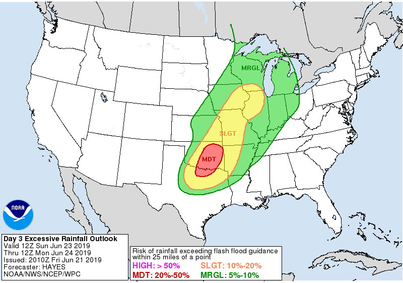
Ntxw wrote:Area of moderate excessive rainfall risk in southern OK and parts of NTX. Very high dew points continue up until the passage of the MCS complexes. Very efficient rain producers.

https://images2.imgbox.com/4c/68/7UNTNCCH_o.gif


18z 3k NAM suggests extending that Mod down into DFW
1 likes   
Winter time post are almost exclusively focused on the DFW area.

User avatar
1900hurricane
Category 5
Category 5
Posts: 6059
Age: 34
Joined: Fri Feb 06, 2015 12:04 pm
Location: Houston, TX
Contact:

Re: Texas Summer 2019

#380 Postby 1900hurricane » Fri Jun 21, 2019 8:05 pm

The dewpoint briefly touched 80ºF here today. That's a little excessive.
6 likes   
Contract Meteorologist. TAMU & MSST. Fiercely authentic, one of a kind. We are all given free will, so choose a life meant to be lived. We are the Masters of our own Stories.
Opinions expressed are mine alone.

Follow me on Twitter at @1900hurricane : Read blogs at https://1900hurricane.wordpress.com/


Return to “USA & Caribbean Weather”

Who is online

Users browsing this forum: utpmg and 12 guests