Seems unlikely given the intensity of this first round, likely to have significant subsidence behind it but some big CAPE building back out west

Moderator: S2k Moderators


bubba hotep wrote:12z TX Tech 4k Ensemble run is a bit concerning as it looks to light up the dry line with a 2nd round of storms along I35 later as this first batch continues to push east.
https://i.ibb.co/d4yM5Dx/paintball-UH-thresh25-f15-12z51819.jpg
Seems unlikely given the intensity of this first round, likely to have significant subsidence behind it but some big CAPE building back out west
https://i.ibb.co/K5Z3GvL/SPC-CAPE.png
cheezyWXguy wrote:bubba hotep wrote:12z TX Tech 4k Ensemble run is a bit concerning as it looks to light up the dry line with a 2nd round of storms along I35 later as this first batch continues to push east.
https://i.ibb.co/d4yM5Dx/paintball-UH-thresh25-f15-12z51819.jpg
Seems unlikely given the intensity of this first round, likely to have significant subsidence behind it but some big CAPE building back out west
https://i.ibb.co/K5Z3GvL/SPC-CAPE.png
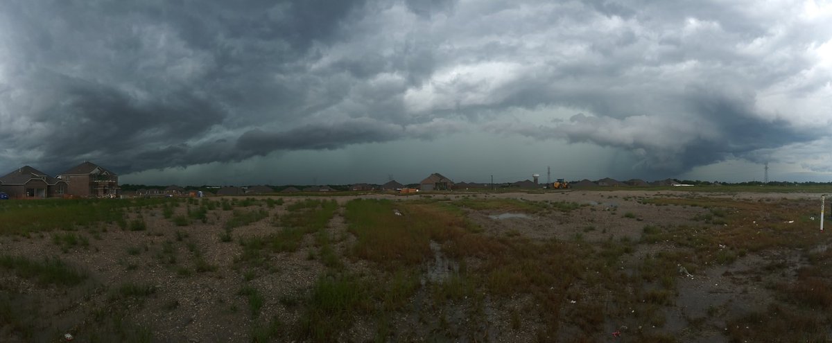
This is happening right now. Look at the storms lighting up over ft worth


bubba hotep wrote:cheezyWXguy wrote:bubba hotep wrote:12z TX Tech 4k Ensemble run is a bit concerning as it looks to light up the dry line with a 2nd round of storms along I35 later as this first batch continues to push east.
https://i.ibb.co/d4yM5Dx/paintball-UH-thresh25-f15-12z51819.jpg
Seems unlikely given the intensity of this first round, likely to have significant subsidence behind it but some big CAPE building back out west
https://i.ibb.co/K5Z3GvL/SPC-CAPE.png
This is happening right now. Look at the storms lighting up over ft worth
The timestamp on that TX Tech image wouldn't have those storms firing for another 4 or 5 hrs. However, that new thin line of storms popped pretty good out of no where for sure.
https://climate.cod.edu/data/nexrad/animations/codnexlab.NEXRAD.FWS.N0Q.20190518.2014.024ani.gif


Haris wrote:Could get interesting in Austin after all!
rwfromkansas wrote:I think DFW is now caught up with last year or ahead of it by this point. There is on little shower trying to pop around Mineral Wells.
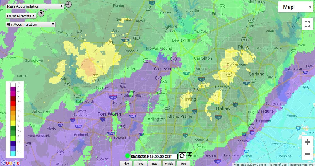
Ntxw wrote:2.15" of rain today at DFW which is a record for the date. Over 7" for the month now


Ntxw wrote:Due to timing issues, I-35 corridor in N and C Texas Mon night-Tuesday morning will (as of now) likely be another MCS passage.
For those in the Panhandle and Oklahoma it could be a strong moderate or high risk tornado day.


Return to “USA & Caribbean Weather”
Users browsing this forum: No registered users and 131 guests